• We have updated our Community Code of Conduct. Please read through the new rules for the forum that are an integral part of Paradox Interactive’s User Agreement.
Status
Not open for further replies.

EU4 - Development Diary - 9th of October 2018

Welcome all to today’s dev diary, where I’ll be covering the long-awaited Iberian and North African map update coming in the 1.28 ‘Spain’ update.

iberia_map.png


Nations released for the sake of example


As things currently stand, though as always things are subject to change before release, Iberia consists of 571 development over 63 provinces. This includes the Macaronesia area but now excludes Labourd, which has been returned to the French region.

In Aragon, the distinction between the Kingdom of Aragon, the Kingdom of Valencia, and the Principality of Catalonia has become more pronounced. Tarragona is now rightly in the Catalonia area, and the province of Valencia has been split so that Castello and Xativa have become separate provinces. Valencia itself has the potential to be a very rich city indeed, as the player’s actions can lead to it becoming a major producer of silk. The three major Balearic Islands have become provinces in and of themselves, linked together by a strait and comprising their own Area.

Likewise, Galicia has seen itself grow from 1 province to 4, and now has an Area all to itself.

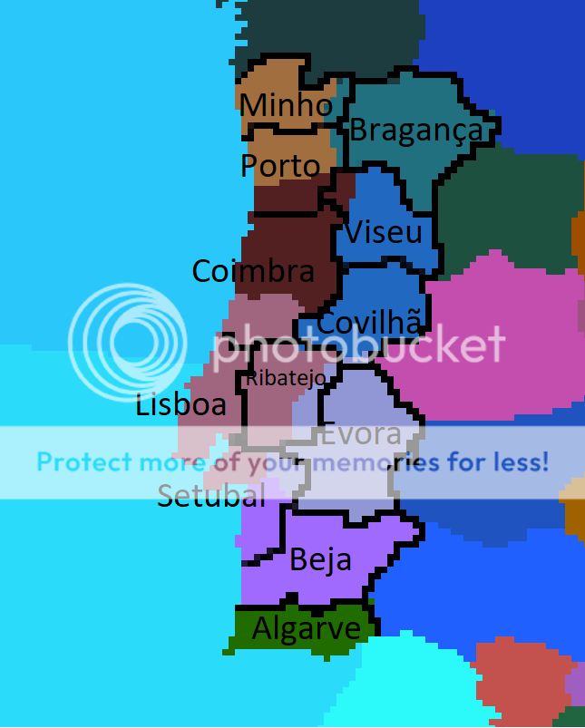
Portugal and Granada have been gifted one additional province each: Aveiro and Malaga respectively.

Last but not least, many citizens of Navarra are looking a little confused as they wonder where their coastline has gone. Wedged between major powers and with no immediate means of escape over the ocean, Navarra will be a very challenging nation in 1.28.

New releasable nations:

Valencia: The Kingdom of Valencia was a major constituent part of the Crown of Aragon in 1444. In 1.28 the former kingdom of El Cid will be a releasable nation.

Asturias: The Kingdom of Asturias ceased to exist long before our start date, but it nicely fills the absence of releasable nations in the region.

morocco_map.png


I’ve also taken another look at North Africa. Here we can see several new provinces along the coast, including those belonging to new nations that can emerge during the game.

The province of Demnate allows a route through the Atlas mountains; a convenient shortcut and potentially a deadly choke-point.

The Canary Islands have been split between Gran Canaria and Tenerife to represent the somewhat incomplete Castilian conquest and colonization of the islands.

For the masochists among you who play as Granada, they now have a core on the province on Ceuta.

New releasable nations:

Salé and Tétouan: Home to some of the most infamous Barbary Pirates, these nations will be releasable in 1444, and may emerge dynamically in the course of the game in the style of Habsan.

fezzan_map.png


Finally, I’ve made some minor changes to the eastern Maghreb. The province of Kairwan has been added for Tunis, and the addition of Sabha has allowed a more aesthetic redrawing of Fezzan’s borders.

That’s all for today. Next week, @Groogy will reveal some of the new features coming in the as yet unnamed Immersion pack to be released alongside 1.28.
 
Last edited:
  • 1
  • 1
Reactions:
I don't like how non-granular central Castile is, there are still too many inorganic-looking rectangular provinces there. I understand that central Spain has always been very sparsely populated compared to her coastline, but I think that is better represented through the Iberian coast being more development-intensive compared to the center, (barring Madrid/Toledo) whilst maintaining the consistent province density paramount for a Western European major like Castile.

Aragon is already significantly over-powered compared to her neighbouring sister Kingdom, too. Bearing in mind Castilian territory had over quintupal the population of the Aragonese lands, I'd consider nerfing Aragon's development slightly as well as the addition of my previously-stipulated extra provinces in central Castile. Adding the Kingdom of Majorca as a releasable tag would be great too.

Finally, Portugal desperately needs another province or two, certainly some development bare minimum, to increase her base economy to help her sustain her colonial efforts, a competitive naval force and power projection capacity.
 
Last edited:
Thanks for this! Great work!!!
I'm from A Coruña and I'm pleased to finally see my province in EU4, and you made my day with Galicia growing like that, my only concern is that Lugo should be the biggest province there, it looks a little weird as it is right now. Lugo should border the other three galician provinces. Maybe with a shape like this Pontevedra fits better as province name instead of Vigo

View attachment 409627 View attachment 409712
Also I support the idea that Portugal deserves something more than one province in an Iberian update...
Anyway, good job, it's nice to see that you are listening to us.
Modern Spanish provinces were first drawn on a map with the shape they have today in 1822. Today's exact division of Galicia into these four provinces wasn't a thing until the reforms of the 19th century. The ones drawn by paradox here are fine as territories more or less centred around a city.
 
Thanks again for the iberian patch and for listening and taking in consideraiton the aid and rants of everyone.

We still don't know what your work on Navarras and Portugals ideas, missions and/or events are so there may lie the reasons for the lack of changes some people are demmanding on those nations provinces and cores. As there's no way to please everyone just keep trying to make the game stay in better shape it ever was.

And as for the asturian tag I can't miss sharing an asturian joke that says "Asturias is Spain, and the rest is reconquered land".
 
Last edited:
It doesnt really make sense that Galicia gets 3 provinces and Portugal only gets 1.


Because Galicia with 30,000 km2 had 1 province and Portugal with 92,000 km2 had 10 provinces.

That is, either we put Portugal with 3 provinces or we put Galicia with 4.

Not to mention that in 1800, Galicia had almost half the population of Portugal (see wikipedia)

Maybe, for all this put a +3 in Galicia and a +1 in Portugal.

And eye, it could be a + 2 in Portugal.
 
I don't like how non-granular central Castile is, there are still too many inorganic-looking rectangular provinces there. I understand that central Spain has always been very sparsely populated compared to her coastline, but I think that is better represented through the Iberian coast being more development-intensive compared to the center, (barring Madrid/Toledo) whilst maintaining the consistent province density paramount for a Western European major like Castile.

Aragon is already significantly over-powered compared to her neighbouring sister Kingdom, too. Bearing in mind Castilian territory had over quintupal the population of the Aragonese lands, I'd consider nerfing Aragon's development slightly as well as the addition of my previously-stipulated extra provinces in central Castile. Adding the Kingdom of Majorca as a releasable tag would be great too.

Finally, Portugal desperately needs another province or two, certainly some development bare minimum, to increase her base economy to help her sustain her colonial efforts, a competitive naval force and power projection capacity.


On the contrary, between 1450-1600 the center was more inhabited than the coast. Castilla with 4 times the size of Aragon, had 6 times its population

Now it's the other way around, but we're in 2018.

In those days life on the coast was worse.

I advise you my thread:

https://forum.paradoxplaza.com/foru...stilla-spain-with-data-and-documents.1091877/

And this document, from page 400


https://castellavetula.files.wordpress.com/2012/07/1829-libro-de-los-millones.pdf
 
Because Galicia with 30,000 km2 had 1 province and Portugal with 92,000 km2 had 10 provinces.

That is, either we put Portugal with 3 provinces or we put Galicia with 4.

Not to mention that in 1800, Galicia had almost half the population of Portugal (see wikipedia)

Maybe, for all this put a +3 in Galicia and a +1 in Portugal.

And eye, it could be a + 2 in Portugal.

1- that's very, very unlikely that Galicia ever had half the population of Portugal. Not even sure it surpassed Lisbon's area in 1800. Not sure either of the reliability of pop census by the time. Nowadays Portugal is 4x more populated even being the european country with the biggest proportion of its population in foreign countries (more portuguese people in Europe and North America than in Portugal, so yes, even without counting ex colonies).

2- Province numbers are not only a matter of size. That being said, now do the comparison with Aragon or Ireland instead of Castile, which lacks provinces too anyway.
 
Because Galicia with 30,000 km2 had 1 province and Portugal with 92,000 km2 had 10 provinces.

That is, either we put Portugal with 3 provinces or we put Galicia with 4.

Not to mention that in 1800, Galicia had almost half the population of Portugal (see wikipedia)

Maybe, for all this put a +3 in Galicia and a +1 in Portugal.

And eye, it could be a + 2 in Portugal.
I already told you, in wikipedia the source of the portuguese census were only to adult males.

You do not give up, but nowadays there are over 50 millions portuguese in the world, while spaniards are around 70millions...
 
Regarding other Iberian nations, which suggestions would you give us to improve map changes?

In the current map, the Asturias region is flat (grasslands, might it be?). Actually, it might be easily one of the most mountainous regions in Spain. The mountains there are not going to be Swiss level mountains nor Pyrinees level mountains, but I'd say that "grasslands" is plainly wrong.

Some info: https://en.wikipedia.org/wiki/Asturias#Geography_and_climate (this is the english version, the spanish version, https://es.wikipedia.org/wiki/Geografía_de_Asturias, says that the regions is mountainous). There is also a list of mountains and peaks in https://es.wikipedia.org/wiki/Anexo:Montañas_de_Asturias. I would say that 170 mountains, each one having a height around 2000 meters shouldn't qualify as "grassland". :p

The thing with Asturias is that it is a line of mountains in the south of the region, bordering with Leon, then a hilly landscape until you get to the coast. Development there should be low, especially in the Trade section (I guess trade would be the best value representing things like roads and the like), because building roads in Asturias has always been expensive and complex.

It's a minor thing, but it would be more correct. Also, once the industrial revolution kicked in, Asturias began to be famous by its coal. The coal was actually of a lower quality than that of England or Germany, but it might be a source of coal in the game. Maybe having a low production figure could do it.
 
A positive update, I especially like the change to Galicia! But I am disappointed with the change in Portugal, the new province doesn't make much sense and it still fails to give Portugal any sort of strategic depth. The map changes seem to make Portugal even more lacklustre in comparison to its Iberian neighbours (in both historic and game terms), particularly in regards to Aragon. Central Spain also looks still a bit underwhelming. But I guess that the dev changes and especially mechanical changes will a much bigger impact, so I'm looking forward to see what's in store.

akjefkegafae_zpsdnwd58c3.png


I hope the devs can give some attention to this.
These are all the plausible provinces that Portugal may have! (All of them would be great but I understand we have to compromise)
Minho - capital Braga
Porto - Douro estuary and trade center
Bragança (the region is called Trás os Montes)
Coimbra - Place of University of Coimbra, one of the oldest in Europe. (The region is Called Beira Litoral; Littoral Beira)
Viseu (The region is called Beira Alta; upper Beira)
Covilhã - a big industrious center in late 1700 and 1800 mainly in textiles (The region is called Beira Baixa; Lower Beira)
Lisboa - Estuary and trade center
Ribatejo - capital Santarém. A lot of agriculture and cattle production here!
Evora - Forts and defensiveness! (The region is called Alto Alentejo; upperAlentejo)
Beja - Grains and agriculture (The region is called Baixo Alentejo; Lower Alentejo)
Setubal - Sado estuary, big salt production. (Also part of the Alentejo region) The province can be called Vale do Sado (Sado's valley)
Algarve - (Guadiana Estuary, shared with Huelva (Castille))

Or you can just follow this official map of the Portuguese Regions.
Zona+Norte.jpg
Good suggestion, I like that Lisboa is two provinces away from the border so that its defense can actually have some strategy, and that Porto would also be possible to defend, but I think asking for 12 provinces in the Portuguese mainland is too much, that's almost as much as Ireland! :p Maybe split Ribatejo between Coimbra and Setubal?
Hello there.
First thing i'd like to say: I like the map changes but i don't think they are enough. Second thing, i really appreciate that change in the canaries islands, this way Portugal can make a run for them like it happened and I like to see something that I suggested in the map

I was preparing a bigger post regarding Portugal in 1444, and i will post it later in the suggestion forum, but right now i fell that I have to say something just regarding the map. I will write from a portuguese point of view. In my opinion Right now Portuguese armies can't hide from a spanish atack. In the north there isnt a single fort and the defensive lines arent represented (Linha do Tejo and Linha do Mondego). ate least 5 cities should be represented: Braga, spliting Porto and getting something from Bragança; Viseu and Guarda, Viseu getting something from new Aveiro and some from old Beira. Guarda, getting nort part of Beira Province. Castelo Branco, getting south part of Beira province; Santarem getting north part of Lisboa province. One more province that I think it deserve to be represented is Elvas. It is the biggest fortress in Europe and like Coquetin province in Normandy it would give a advantage deepth necessary to Portugal. (Olivença should be part of this province)
These provinces should be poor. They werent heavily populated in 1444.
Now, regarding Spanish side, Badajoz split between bradoz and Merida. If you conquer Badajoz you are not at Toledo doors.
Extremadura split between Caceres and Plasencia. Talavera province should be added to west side of Toledo and Castilla la Mancha.
And that's it regarding the map. Other considerations regarding Portugal in 1444 i will made them in the suggestions forum
Great post. I agree that the choice of provinces should reflect at least in some sense the "military geography", EU4 is mostly about war after all. As it stands, an invasion of Portugal from the Spanish side is embarrassingly straightforward, while in reality it was certainly not the case as French and Spanish found out repeatedly.

Historically speaking Castille and Portugal were good allies
Huh? Is this is what happens when you learn history from playing EU4? ;)
 
Last edited:
Good thing the game starts 28 years before that, eh?

Here's an idea; at the start of the game, both Aragon and Portugal have historical friend with Castille. If you as Castille can get through the age without triggering the Castillian Civil War then it's sunshine and rainbows between the iberian nations (with perhaps new opportunities to get PU events for both) but if you don't, you have to pick one, and the disaster will end with you losing the Historical Friend with the loser and get an Iberian Wedding with the winner.

I really like this idea. I think there should also be a way for a Portugual player to become the senior partner of the union much like an Aragon player in the current version of the Wedding. The AI should be weighted to choose Aragon nearly every time.
 
I've always been a personal fan of Victoria 2's Portugal and Southern Spain set-up. Some obvious things that seem off (2 province Galicia) but still a really nice looking map.


bfNVZMc.png
 
Nice! I like a lot this 4 provinces Galicia.

Personally I would preferred to use those 2 new provinces in mainland Iberia instead of brake off Baleares.:p

But after all these criticism in the thread I must praise the quick replay of devs, theirs explanations and their will to listen and revise thier work based in some of those observations. This is one of the reasons I like Paradox, you listen to the fans. :)
 
We need multithreding more than anything. This game is so incredible, but after all those new provinces added it kills my 4th generation i7. I mean it kills only one core because this is the issue im talking about. Starting to be a little unplayable at a certain point. Hope it will change soon.


Good idea.

Paradox please stop development of the game so IMAGY’s old processor won’t lag his PC while playing.
 
OK last time I bother you about Olivenza devs (maybe ;))
index.php

New Iberia map lacking olivenza
250px-Oliven%C3%A7a_location.PNG

Olivenza in modern day Spain

"Olivenza had its origins in the conquest of Badajoz by Alfonso IX, King of Leon, in 1230. Some years later, the Knights Templar seized Olivenza and built a citadel there. In 1297, Olivenza was ceded by Ferdinand IV, King of Castile and Leon, to King Dinis of Portugal in the Treaty of Alcañices. The King of Portugal raised Olivenza to the status of a royal borough and fortified it in view of its strategic importance at the border between the two kingdoms. After experiencing a Golden Age in the 16th century, Olivenza was caught up in the Portuguese revolt of 1640 and was captured by Spain in 1657 but restored to Portugal by the Peace of Lisbon in 1668. The town remained Portuguese for almost one and a half centuries before falling to the Spanish troops who invaded Portugal in the War of the Oranges (1801). Article III of the Treaty of Badajoz, concluded that same year between Spain and Portugal on the one hand and between Portugal and France on the other, confirmed Spanish sovereignty over Olivenza. Portugal did not recognize that annexation, and soon afterwards Prince Joao, the Prince Regent, denounced the Franco-Portuguese treaty. In accordance with the preamble to that treaty, his action also rendered the treaty with Spain null and void. Thereafter, the Treaty of Fontainebleau, by which Spain and France agreed to partition Portugal, effectively annulled the Treaty of Badajoz. Following the defeat of Napoleon, Article 105 of the Final Act of the Congress of Vienna (1815) laid down that the victorious European powers would act as intermediaries between Spain and Portugal with a view to the restitution of Olivenza to Portugal. The negotiations were never begun, and even today Portugal considers Olivenza to be a Portuguese territory de jure".

Seeing as it was owned by Portugal almost all of the time line plus more than 150 years before, I don't see any reason to not have it owned by Portugal on the map maybe even make it a separate three development province, preferably with a fort.

source: https://www.uoc.edu/euromosaic/web/document/portugues/an/i1/i1.html
 
Status
Not open for further replies.