• We have updated our Community Code of Conduct. Please read through the new rules for the forum that are an integral part of Paradox Interactive’s User Agreement.

Tinto Maps #1 - 10th of May 2024 - Low Countries

Hello everybody, and welcome to the first post of Tinto Maps! This is a new weekly series that we will be running about the top-secret game Project Caesar.

Let me introduce myself before I continue, as some of you may get to know me from the development of the latest EUIV DLCs, but I might not be as well-known to everyone as Johan. I’m Pavía, the Content Design Lead at Paradox Tinto, which I joined in 2021. Before becoming a videogame developer, my background was as a Historian, which led me to work on a PhD. in Medieval History (fool me!), which I finished in 2020. Besides that, I’ve spent several thousands of hours of my life playing Paradox GSGs since I discovered and started playing Europa Universalis 20 years ago, in 2004.

What this new series will be about is quite straightforward: each week I will be sharing with you maps of a new different region, so you have an outlook of them and we are able to receive early feedback (because as you may already know from Johan’s Tinto Talks, there is still a lot of WIP stuff ongoing).

About this feedback, we’d like you to take into account a couple of things. The first is that we’ve worked really hard to gather the best sources of information available to craft the best possible map; we used GIS tools with several layers of historical map sources from academic works, geographical data, administrative data, etc., to help us ensure the desired quality. So we would appreciate getting specific suggestions backed by these types of sources, as others (let’s say, a Wikipedia map or YouTube video with no references) may not be reliable enough. The second thing to comment on is that sometimes a certain decision we made was an interpretation over an unclear source, while sometimes we have just plainly made some errors when crafting the map (which on a 30,000 location map is a normal thing, I guess). I’ll let you know when any of these happen, and I’m also going to ask for your understanding when an error or bug is found and confirmed as such.

With those forewords said, let’s start with today’s region: the Low Countries! This is what the political map looks like:

Countries.png

The regional situation in 1337. The counties of Hainaut, Holland, and Zeeland are ruled by William of Avesnes, who is married to Joanna, daughter of Duke John III of Brabant. Another John, the Duke of Luxembourg, might be the strongest power, as he is also the King of Bohemia. The County of Flanders is the wealthiest country in the region, controlling such important cities as Brugge and Ghent. Up in the north, we have other interesting countries, such as the Bishopric of Utrecht or the Republic of Frisia (you might notice that we're using a dynamic custom country name for them, 'Frisian Freedom').

And here we have the locations:

Locations.png

We had a fun bug for some time - Antwerpen didn’t have any pixels connected to the sea, which we found because we couldn’t build any type of port building there. There’s a happy ending, as the bug has already been corrected, and Antwerpen can finally have a proper port!

Provinces:

Provinces.jpg


Terrain (Climate, Topography, and Vegetation):

Climate.jpg

Topography.jpg

Vegetation.jpg

We are aware that the Netherlands looked differently in the 14th century, as several land reclamations took place during the Late Medieval and Early Modern periods, but we are using a 20th-century version of the map for the sake of consistency. Most of the regions throughout the world would look quite different from nowadays, and documenting those changes (especially the coastline shapes) would be a non-trivial problem to resolve. As a side note, we already removed Flevoland from it, and have already identified some other modern ones that slipped through and we'll eventually remove them, as well.

Cultures:

Cultures.png

The stripes mean that there are pops of different culture inhabiting in those location. Also, the German and French cultures are WIP, we’ll show you a proper version on later Tinto Maps.

Religions:

Religions.png

Not many religions here yet, although there will be interesting religious stuff happening eventually…

Raw Goods:

Goods.png

Goods get regularly swapped around here and there to have a balance between geographical and historical accuracy, and gameplay purposes. So take this as the far-from-final current version of them.

And an additional map for this week:

Markets.png

We reinstated a Low Countries market centered on Antwerpen, after doing some balance tweaks that made it more viable.

And these are the maps for today! I hope that you have a nice weekend, and next Friday, we will travel down south, to Iberia!
 

Attachments

  • Climate.jpg
    Climate.jpg
    357,1 KB · Views: 0
  • Topography.jpg
    Topography.jpg
    402,8 KB · Views: 0
  • Vegetation.jpg
    Vegetation.jpg
    414,6 KB · Views: 0
Last edited:
  • 340Love
  • 133Like
  • 6
  • 3
  • 1Haha
  • 1
Reactions:
wonder what are the implications of this? will the different branches of oğuz also be present in anatolia, mashrık, azerbaycan or is this privilege only afforded to europoors as lindy said once
Since, Anatolia is way more divided.
For me, it makes sense to split Turkish culture into Turks, Yorouks and Turkomans
 
  • 1
  • 1Like
Reactions:
Not ATM, quoting Johan on this:
Dynamic terrain would be amazing, its one feature thats always been missing from PDX games despite being important in history

Also, cant wait to nitpick the hell out of the nordics
 
Last edited:
  • 1Like
Reactions:
  • 26
  • 5Like
Reactions:
Suppose you are Hesse, any way to prevent Hesse acquiring single locations in a snake line to reach the ocean? The geopolitics themselves should make such a thing improbable but not impossible. Since EU4 has a smaller map scale, you probably only need 4-6 provinces to make it to the ocean. Here you probably need closer to 15+ locations.

Its just inefficient to control
 
  • 18
  • 10Like
Reactions:
As someone who is quite bothered with all the wrong stuff in CK3 that has not been changed even so many years after release despite the many feedbacks, I really appreciate that this time around devs actually care about it and ask for feedback even before release.
 
  • 5
  • 1Like
Reactions:
Hopefully this is a question that isn't [REDACTED] to answer at this point, but how big is the entire world map on a pixel scale? For example, the EUIV map is 5632 x 1048 and the province map for the Netherlands looks like this:

Base data is 16384x8192
 
  • 38Like
  • 26Love
  • 9
Reactions:
As someone who is quite bothered with all the wrong stuff in CK3 that has not been changed even so many years after release despite the many feedbacks, I really appreciate that this time around devs actually care about it and ask for feedback even before release.
Fingers crossed the minimum one FTE needed for this amount of feedback is budgeted.

And next time all of Iberia? Good luck :)
 
To add to the previous comment about inconsistent names:

- In Brabant, most locations use the Dutch names, but Brussels is English (Dutch would be Brussel) and Wavre is French (Waver in Dutch).
- In Flanders, most locations have Dutch names, but Bruges (Brugge) Cassel (Kassel), Ypres (Ieper) and Dunkirk (Duinkerke) use French or English names instead of Dutch. Ostende would be Oostende in Dutch, but currently has its Flemish name.
- Hertogenbosch is incorrect and should either be 's-Hertogenbosch (with the apostrophe and the lowercase s) or just Den Bosch. Den Bosch is the older name of the two, and also matches Den Haag (which is sometimes also called 's-Gravenhage).
In the Flemish accent we often call it Wavre as well but with a Flemish/Dutch pronunciation.
 
  • 2Like
Reactions:
Small issue with the naming of a province I recognised because I know the area.
The province of Olpe should probabl be named either Bilstein or Attendorn. Bilstein was the seat of the local administration for much of the area and the main seat of the noble family von Fürstenberg that controlled the area from the 16th century. Attendorn was the most important and populous city (even a member of the Hansa, though a fairly low ranking one being represented by Soest) of the area until relatively late in what would be the games time span, only being surpassed by Olpe in the early 19th century.


Map of the area in 1725. You can clearly see the big red dot representing Attendorn. Bilstein and Waldenburg were often ruled together and you can also see Olpe being a part of the Amt Waldenburg.
1725_Gericht_Attendorn%2C_%C3%84mter_Bilstein_und_Waldenburg.jpg
 
Last edited:
  • 2Like
Reactions:
Antwerpen is quite convenient gameplay-wise as a center, as it's in between Köln and London market centers. But testing Brugge instead of Antwerpen is something that we've internally discussed, and that we may do soon.
The Brugge/Sluys to Antwerpen switch is probably worth investigating in game play, agreed. For a good reference concerning the shifts in the trade networks in this period (worldwide, not just European) I can recommend "Before European Hegemony" by Janet L Abu-Lughod, as it covers this and many other features of the period from the point of view of trade and naval dominance.
 
  • 1Like
Reactions:
Before becoming a videogame developer, my background was as a Historian, which led me to work on a PhD. in Medieval History (fool me!), which I finished in 2020.


The first is that we’ve worked really hard to gather the best sources of information available to craft the best possible map; we used GIS tools with several layers of historical map sources from academic works, geographical data, administrative data, etc., to help us ensure the desired quality. So we would appreciate getting specific suggestions backed by these types of sources, as others (let’s say, a Wikipedia map or YouTube video with no references) may not be reliable enough.

As an academic who uses GIS and old maps extensively in my research, this warms the cockles of my heart.
 
  • 1Love
Reactions:
yes of course you can acquire single locations
How do you avoid cluttering the war goal screen with every single enemy location? Of course, for all I know PC might not even use a war goal screen, but I assume that it uses some kind of similar system to let the player customise their peace deals.
 
Hello everybody, and welcome to the first post of Tinto Maps! This is a new weekly series that we will be running about the top-secret game Project Caesar.

Let me introduce myself before I continue, as some of you may get to know me from the development of the latest EUIV DLCs, but I might not be as well-known to everyone as Johan. I’m Pavía, the Content Design Lead at Paradox Tinto, which I joined in 2021. Before becoming a videogame developer, my background was as a Historian, which led me to work on a PhD. in Medieval History (fool me!), which I finished in 2020. Besides that, I’ve spent several thousands of hours of my life playing Paradox GSGs since I discovered and started playing Europa Universalis 20 years ago, in 2004.

What this new series will be about is quite straightforward: each week I will be sharing with you maps of a new different region, so you have an outlook of them and we are able to receive early feedback (because as you may already know from Johan’s Tinto Talks, there is still a lot of WIP stuff ongoing).

About this feedback, we’d like you to take into account a couple of things. The first is that we’ve worked really hard to gather the best sources of information available to craft the best possible map; we used GIS tools with several layers of historical map sources from academic works, geographical data, administrative data, etc., to help us ensure the desired quality. So we would appreciate getting specific suggestions backed by these types of sources, as others (let’s say, a Wikipedia map or YouTube video with no references) may not be reliable enough. The second thing to comment on is that sometimes a certain decision we made was an interpretation over an unclear source, while sometimes we have just plainly made some errors when crafting the map (which on a 30,000 location map is a normal thing, I guess). I’ll let you know when any of these happen, and I’m also going to ask for your understanding when an error or bug is found and confirmed as such.

With those forewords said, let’s start with today’s region: the Low Countries! This is what the political map looks like:

View attachment 1130588
The regional situation in 1337. The counties of Hainaut, Holland, and Zeeland are ruled by William of Avesnes, who is married to Joanna, daughter of Duke John III of Brabant. Another John, the Duke of Luxembourg, might be the strongest power, as he is also the King of Bohemia. The County of Flanders is the wealthiest country in the region, controlling such important cities as Brugge and Ghent. Up in the north, we have other interesting countries, such as the Bishopric of Utrecht or the Republic of Frisia (you might notice that we're using a dynamic custom country name for them, 'Frisian Freedom').

And here we have the locations:

View attachment 1130589
We had a fun bug for some time - Antwerpen didn’t have any pixels connected to the sea, which we found because we couldn’t build any type of port building there. There’s a happy ending, as the bug has already been corrected, and Antwerpen can finally have a proper port!

Provinces:

View attachment 1130889

Terrain (Climate, Topography, and Vegetation):

View attachment 1130626
View attachment 1130627
View attachment 1130628
We are aware that the Netherlands looked differently in the 14th century, as several land reclamations took place during the Late Medieval and Early Modern periods, but we are using a 20th-century version of the map for the sake of consistency. Most of the regions throughout the world would look quite different from nowadays, and documenting those changes (especially the coastline shapes) would be a non-trivial problem to resolve. As a side note, we already removed Flevoland from it, and have already identified some other modern ones that slipped through and we'll eventually remove them, as well.

Cultures:

View attachment 1130590
The stripes mean that there are pops of different culture inhabiting in those location. Also, the German and French cultures are WIP, we’ll show you a proper version on later Tinto Maps.

Religions:

View attachment 1130591
Not many religions here yet, although there will be interesting religious stuff happening eventually…

Raw Goods:

View attachment 1130592
Goods get regularly swapped around here and there to have a balance between geographical and historical accuracy, and gameplay purposes. So take this as the far-from-final current version of them.

And an additional map for this week:

View attachment 1130593
We reinstated a Low Countries market centered on Antwerpen, after doing some balance tweaks that made it more viable.

And these are the maps for today! I hope that you have a nice weekend, and next Friday, we will travel down south, to Iberia!
I am weeping from the beauty but shouldn't the eastern portion of the Netherlands south of Frisian Freedom be low German culture? Also, weren't the coastlines in this period different?
 
  • 1Like
Reactions:
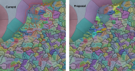
Hi! I've been religiously following the updates so far and I just have to put my own two cents in here. Also building off of the suggestions by Pbhuh here.
Included is a few maps for reference points.

A main point for everything: I see there is inconsistency in naming, especially when it comes to language. Two parts: cardinal directions and names. For cardinal directions, either stick with English or keep to local names. For instance, North Holland is typed as Noord Holland in Dutch but North Brabant is in English.
For names, it is of course of to the team whether they want the local or English name, for flavor I prefer local of course. I will try to give recommendations in this text.

Halfway through writing I realized you use town names for locations, not region names oops, I fixed this.

1. "West Friesland" as province might confuse this province with the West Friesland in North Holland. Alternatives would be just "Friesland", "Middle Friesland", or (topic about languages and names later) "Fryslân". West Frisia is not an unheard of option for this province.
Fryslân (the name I'll stick with for now) was traditionally split in three; I think this is better than the current 4. (See proposal and b./c.)

1a. Vlieland (the island in blue) was part of the gewest of Texel in this time period, even though in modern times it is part of Fryslân. I think keeping it part of Hoorn makes sense, so this is good.
1b. Leeuwarden in not in this location. As per proposal, this location would correlate with the Frisian quarter of Zevenwouden/Sânwâlden. The biggest town here would probably be Sloten (frisian: Sleat), although De Lemmer looks close (this would be in Zwolle tho).
1c. Makkum is not a big city in this time period and would be overshadowed by Stavoren and Sneek, I think (maybe preference) Sneek (Frisian: Snits) is the better pick.
1d. This region would now be Leeuwarden (Frisian: Ljouwert/Leewarden). Also, the eastern most island here is Schiermonnikoog. I'm not sure if it's part of the Groningen location here, but it should be in the Dokkum (now Ljouwert) location, due to its Frisian history and modern place in Frisia.

2. The modern province of Groningen was called Stad en Ommelanden during this time, Ommelanden fits well. There is a stark difference between the city of Groningen and around it.
In my proposal, there's 4 locations, slightly different. Groningen (local/saxonish: Grunn) was east dutch/saxon in culture, so whatever is decided for the culture, it should not be Frisian, but either Dutch, or Lower Saxon if that get added for this region. It was also part of the bisphoric of Utrecht politically, Pbhuh also said it might be independent due to its autonomy. The others locations are Hunsingo in the North headed by the town Winsum (could not find a frisian name, but maybe Winzum), Appingedam within Fivelingoa (Frisian: Appingedaam), and in the east the location of Wedde, which I don't think needs changing.

3. Other people already pointed out that Drenthe is not very noteworthy, and might not need 3 locations. I think two would be fine. In any case, Coevorden's location here on the map is definitely wrong. I made a proposal splitting it in 2 (Assen and Koervern, the latter as per dutch Saxon name), but would like to add as other people said that Bentheim right over the border should probably have its own location!

4. I agree with Pbhuh here, but nothing too much of note

5. Mostly agree with Pbhuh here as well, although I would like to see Harderwijk (Dutch Saxon: Harderwiek) remain for 3 reasons: it was a city with rights, it's awkward for Arnhem to have a port and Harderwijk on the coast makes more sense, and aesthetic reasons :p Tiel should definitely have its own location to break up the length of Nijmegen and to compensate for the removal of Apeldoorn.

6. North-Holland I think deserves 4 locations as well. Every location added might pose the question if it is warranted, but the Netherlands and Flanders were pretty much the densest populated part of Europe outside of the Po Valley. I suggest adding Haarlem as a region. Hoorn is good as a Frisian culture location, and the name in west-frisian (note: not frisian but the local dialect) is the same. If you want, in Frisian Frisian it is Hoarn.

7. Utrecht should really also be split in two, considering the density of the area. (plus it kinda sticks out, a lot).

8. Zuid-Holland is a bit of a mess to be honest, the rivers are very hard to understand here, and thus also the locations of the cities. There is too much land here in the first place, and an island called Goeree-Overvlakkee here is not even an island. See my proposal for where the cities are located and how I imagine the locations, rivers, and coast.

9. Zeeland really needs to be looked at as well, the coastlines are not correct with this era. Because of my changes to 8, I propose having three locations here, Breda, Bergen op zoom, and Geertruidenberg (which I'm pretty sure was part of Holland in this time as per the political map)

10. Roermond is very much misplaced. This should be Heinsberg. It was it's own lordship at the time, though I'm not sure if they're independent enough for the game ;)

11. These place names are not consistent with the language naming. If Dutch/Flemish these should be (left to right) Duinkerke, Kassel, Ieper, and I'm not sure why the team decided for a y in Kortrijk (typo?).

12. The border between modern Netherlands and Belgium is slightly different here, you may have a reason for this exact shape but if not, I propose following the border of nowadays.

13. This isn't something we can see now, but the water in the middle of the country nowadays is called the IJsselmeer, just to check because before the Afsluitdijk was built in the 20th century, this body of water was called the Zuiderzee (Southern sea). Hopefully that name is correct in the name of the water tile.

I also think in general the coast should be reconisidered, going for the coastline as it was in the 16th-17th century might be a better balance for the time period of the game.

Those were my thoughts and inputs for the map. In my opinion I think it's worthwhile to really consider adding Low/Dutch Saxon into the game. I'm not sure about the split in Flemish when it comes to Brabant. Kleve and other border areas in this time were more aligned (from what I know in my History studies) to be Dutch in culture, and I hope you guys research the exact delimitation you're going with. Thank you for reading :D
 

Attachments

  • Proposal low countries proj Caesar.png
    Proposal low countries proj Caesar.png
    1,6 MB · Views: 0
  • 15Like
  • 3
  • 2
Reactions:
I like this a lot!

I remember Imperator's dev diaries about cartography, they didn't show as many different versions of the map but we got a short presentation of every tag in the region... I don't think it would be reasonable here considering the number and density of tags is likely far higher, but a list of local formables (and maybe releasables) would be appreciated.
 
We had 3 options for the cultures:
1. Just go with Dutch, based on the language.
2. Portray the 4 regional variants/dialects of Middle Dutch (Flemish, Brabantic, Hollandic, Limburgic), plus Dutch Low Saxon.
3. Opting for an intermediate level, grouping Flemish, Brabantic, and Limburgic under Flemish, and Hollandic and Dutch Low Saxon groups under Dutch (as they also had a really close relationship). This is the one we decided to go to, for the moment.

We also discussed internally Overijssel and the Dutch Low Saxon region; as we have to review a bit the German cultures, it may change depending on that. And, in any case, we make this new series precisely to gather feedback, so we'll be reading opinions on this topic in the next few days. :)
Would unifying Dutch and Flemish, while making the east of the Netherlands Low Saxon (with maybe Limburg being Rhenish? Or still Dutch, idk much about Limburg) be a good solution? That way Dutch would make more sense as a culture, while the Netherlands is quite split up.

I also feel like it could be nice to have Flemish and Dutch start to split as separate cultures depending on how the Protestant Reformation goes, seeing as that is when the Low Countries really started diverging culturally.
 
  • 8Like
Reactions: