

Hi, fellows. I've been interested in doing some map modding lately.
So, one thing that took my attention some time ago, when I was playing vanilla, was this little weird special province, Guantanamo Bay:
Notice the little map zoom thing. We have a micro-province rendered in a way that makes it look bigger. Fascinating. I notice we can even click on the land surrounding it.
I have several questions:
1. What is this?
2. How I do this?
3. Can I use this to have an area of multiple micro-provinces "zoomed out"? Say, what if I do this to NYC and create like ten or twenty micro-provinces which I zoom out together? Can I do this?
4. Is there a way to make this work out with in-land provinces? Seems like it only works with coastal ones for obvious reasons.
Thank you for your help!
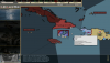
.png "Screenshot (1417).png")
