Thanks for the elaborate reply; unfortunately I lack the time to devote as much study to my own response. Instead let me just give you a few examples of where I would be more cautious:
- You start from the assumption that the sagas describe a place that's not L'Anse Aux Meadows. I don't see exactly which discrepancies lead you to that assumption. Bear in mind here that sagas are rarely precise in every detail.
Thanks for replying, Barsoom. Actually I don't start from the assumption that the sagas don't describe L'Anse aux Meadows. Personally, I would actually have a starting bias that the Sagas do describe L'Anse aux Meadows, because we know as a fact that L'Anse Meadows was a real Viking site south of Labrador. Instead, my approach was to take the Sagas at face value, list their directions, map them, and only afterwards compare their coordinatees with real world places like L'Anse aux Meadows.
In fact, I'm open to the idea that the Sagas at some point do mention an area that includes L'Anse Meadows, such as the Sagas' Cape "Kjalarnes." However, I share a common opinion that the Sagas describe the Vikings settling at a place that is not L'anse aux Meadows, and there a line of good reasons with this, starting with
(A) the Vikings describe their settlements as being a noticeable distance from the northern Cape Kjalarnes, whereas L'Anse aux Meadows is at the north end of the Great Northern Peninsula; and
(B) the two northernmost settlements south of Labrador mentioned as such are Leif's camp where there are grapes, west of Cape Kjalarnes, and the camp at Straumsfjord, which is south of the Wonder-strand shores where the Vikings also find grapes. In contrast, L'Anse aux Meadows is typically considered to be much north of the northern line for grapes in eastern Canada, even for that time. Writing on the topic typically goes that Grapes were found in New Brunswick, with there being different assertions that grapes were found in south Newfoundland as welll due to there being a warmer climate at the time.
(C) The west camp is described as being by a lake, whereas the Straumsfjord camp is by a fjord, neither description matching the area at L'Anse Aux Meadows
(D) The Sagas say it took 2 days to get from Labrador south to Kjalarnes (~66 to 250 miles if consistent with other sailing times in the Sagas), whereas the northern Peninsula that L'Anse Aux Meadows is on is only 10.8-20 miles from Labrador. (You could canoe down a river that distance in 1/2 to 1 days or less.)
There are a host of other ways that L'Anse Aux Meadows doesn't match any of the other such settlements specified.
- One of the data points is the description of the land as not covered by snow in winter but this may be from another source than the sailing distances. It may be from the scribe's imagination, it may be advertisement for settlers (like the name Greenland), or it may be a trope for describing a good land.
- I did see that you are yourself somewhat skeptical on this point, no frost at all would put them at the Carolinas which isn't credible. So how much weight do you want to put on it? If L'Anse is too cold, how far south before it's too warm?
- According to Wikipedia it was debated whether Eric's Saga copied part of the Greenlander Saga; the consensus now is that it didn't but that doesn't rule out one or both of them using tropes common to sagas in general. I would like to know a bit more about how often this snowless thing crops up in descriptions of good lands - is it rare or unique, or is it quite common?
- I do credit something as specific as the time of sunset, just the level of detail makes it seem authentic. The snowless winter is quite generic, though.
In Eric the Red's Saga, the Vikings sail south to Cape Kjalarnes, then go south to Straumfjord and settle with Leif's camp. Then they keep sailing south past another cape, and it's a total of a long time until they get to another land that they name "Hop" (Tidal Pool Estuary). They settle at a lake where it doesn't snow that winter whatsoever. The area has Halibut in the water by the Ocean (It doesn't mention salmon like the Sagas say are farther north around the Vinland). It's reasonable to think that this would be somewhere between the Carolinas and NYC. Halibut today just go as far south as the deep waters at Virginia. Then they sail back up the coast later after the Amerindians attack them, and the Vikings camp on the cape that I mentioned that is between Hop and Straumsfjord.
I laid out the description of the journey described in Eric the Red's Saga in another thread:
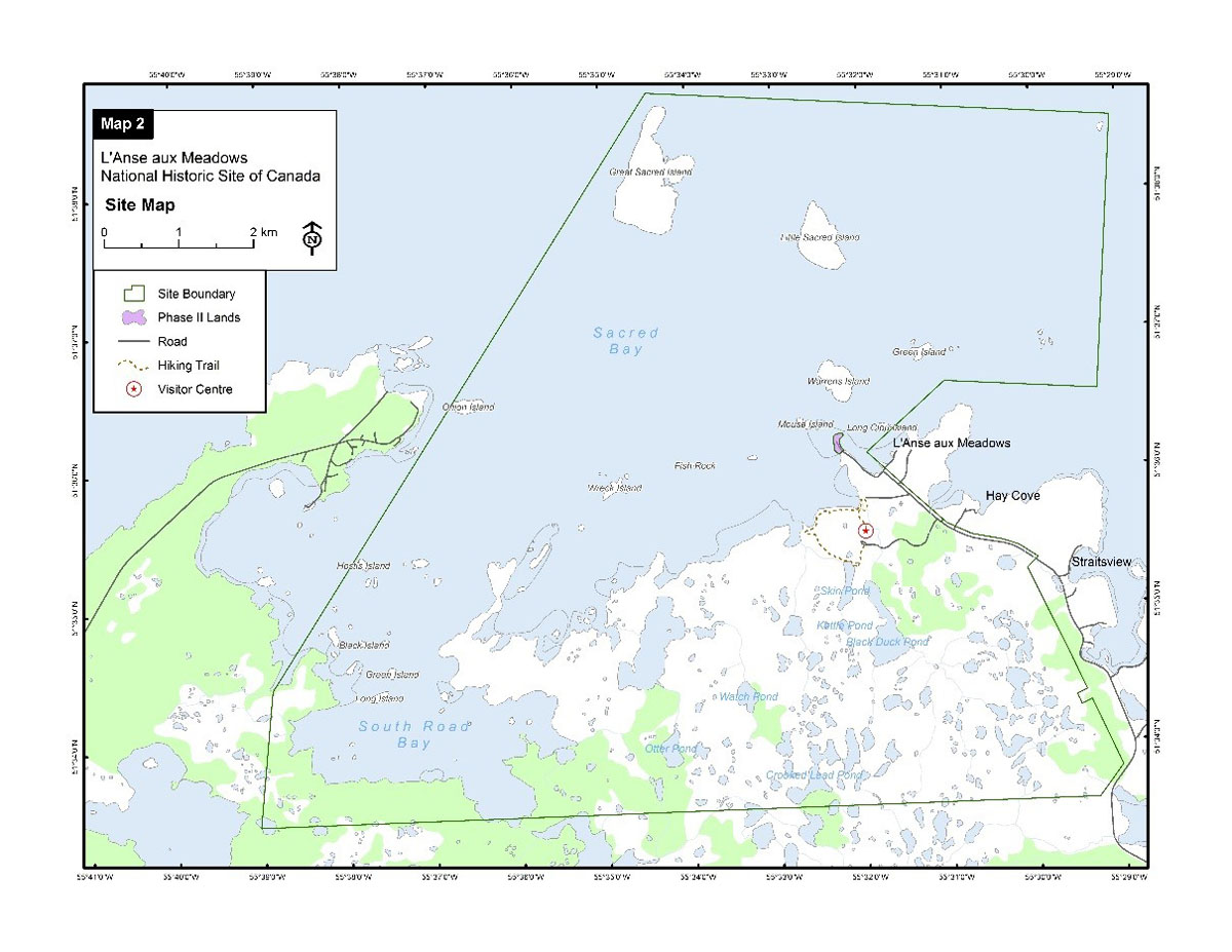
Archaeologists found a Viking settlement's remains in L'Anse aux Meadows, at the northern end of Newfoundland's northernmost peninsula. The Viking site had butternuts, which only grow about as far
www.cruisersforum.com
So in Eric the Red's Saga, the Vikings actually camp in three places on the American/Canadian east coast. We can tell that those places would be on the east coast (like from L'Anse Aux Meadows down the ocean coast to the Carolinas) because they are south and on the east coastline from Cape Kjalarnes, and one time a Viking group got blown west from Cape Kjalarnes back to Ireland.
In the Greenlanders' Saga on the other hand, it only describes the Vikings making a single camp, which is placed to the west of Cape Kjalarnes. It's given a sunshine time and winter description that don't fit each other, and for a couple other reasons the winter description doesn't work:
(A) In the Greenlanders' Saga at Leif's camp, the sunset time for the winter solstice (shortest day in December) is counted at being after 3:30 PM, or maybe after 3:00-4:30 PM. More specifically, the sun is said to be still visible at that time, which actually means that the literal sunset time by current astronomer notation was probably even later. In any case, it points to a location in Newfoundland or any location farther south, but with decreasing likelihood as one goes farther south. This is because if the Viking camp of the Greenlanders' Saga was very farther south like in the Carolinas, the narrator would likely have given a much later sunset time.
(B) The Greenlanders' Saga says that at this camp there was no frost that winter, ie. in real life current terms this would literally be at the Carolinas.
(C) This Saga also claims that there were salmon there at this camp, IIRC. That works for eastern Canada and the NE USA, but not the Carolinas.
(D) Today with the benefit of current mapping, we can see that any promontory that the Vikings would have met on a straight sail south from Labrador, ie. a possible Cape Kjalarnes would not have allowed the Vikings to sail west from that same cape and then south to any place that is snowless in the whole winter, like the US east coast. This is because to the west of any such spot (like the Newfoundland great northern peninsula or Cape Breton or the Gaspe Peninsula), a sailor is blocked by the coasts of New Brunswick, Nova Scotia, and Quebec from going farther south in a westerly direction.
(E) Eric's Saga says that the winter at Leif's Camp at Straumsfjord was harsh, whereas at Hop, the camp (I don't recall if Leif was there) was snowless. Alot of readers imagine that Leif's Straumsfjord camp is the same as Leif's camp in the Greenlanders' Saga. However, at face value, there are two different camps, one by the lake to the west side of Kjalarnes and another on its east side (Straumsfjord).
In any case, the description about the snowless winter in the Greenlanders' Saga is the one that doesn't work as a matter of real world geography as the Viking world would have known it. That is, the latitude with the given sunset time fits at the latitude around the St Lawrence Bay, but doesn't work well with the snowless description however someone living in the Viking period would imagine the Vinland coast to look, and vice verse.
One solution is that the writers of the Greenlanders' Saga was conflating the Viking's northern camp at the >3:30 PM sunset latitude with the southernmost, snowless one.
Another solution could be that the witer was euphemizing / puffing up the snowlessness of the region. But a problem with this solution is that generally the writer doesn't do this kind of boasting. For instance, when he talks about Greenland, the writer notes that Greenland was Eric's name for the land because Eric thought people would rather want to settle there more if it has a "good name." The author is being candid about Greenland's name being puffery. And then later in the Saga, Bjarni says that the forest land in Eastern Canada must not be Greenland because Greenland has many glaciers.
Either way, it doesn't look like Leif's camp down the west coast from Kjalarnes was actually snowless in the winter for the reasons given in A to E above.
To answer your last question: In descriptions of Helluland, Greenland, and Iceland in the two Sagas, I don't find descriptions of them being snowless in the winter. In the Vikings' history about finding Iceland, they say that they winter there, and it's super snowy, and they even call it Snowland at first, but then when one Viking spends the summer there from the winter time, he is amazed to find how Iceland changes so that it gets lush summer forests.
There are a couple times when the two Sagas about Vinland seem fanciful, like when Eric the Red's Saga describes a one footer Native attacking them, and the one footer flees. The fanciful element is the idea of a "one footer" who attacks and flees. I guess the attacker could have been a real person who ran away on crutches or something like that, and the Vikings thought it was remarkable or entertaining enough that they included the event. There is also a ghost story in one of the two Sagas that takes place in Greenland. But overall the fanciful elements don't seem to nullify the realistic-sounding aspect of the coordinates for Vinland in the narrative. Europeans writing real life documents in the era like Adam of Bremen in the 11th century take Vinland to be a real place, and the Pope appointed a bishop for Vinland.
- Norse settlement of Greenland and Vinland took place during the Medieval Warm Period, which raised temperatures everywhere but seems to have had a bigger effect in that region. This would of course affect frost and snow, but also have indirect effects on flora and fauna. Nuts and fruits, as well as fish, may have been found in more northerly habitats than today.
- Or, well, considering global warming in our age, flora and fauna may be migrating north again but I'm not sure whether that's been taken into account. Something to check, I guess.
Right. From what I found with some cursory research was that the difference was only about 2 degrees in temperature. The Vikings were visiting in around 1000 AD, and the climate was actually in transition and the Warm Period was still in its starting and growing phase, so it wasn't making as big an impact as some people might think. Plus, we are today in a warm phase, so our current warm climate actually gives us a better idea of the climate then comapred to if you and I were writing in the 1960s when the Viking site in Canada was found.
The big climate and environmental issues of that time were: 1) The Vikings chopped out the forests of Iceland and Greenland (although they left some in place), and this was a big deal because the Vikings used wood to make boats and buildings. 2) The Little Ice Age of ~1300-1400, which basically was the number 1 reason for the Greenland region getting depopulated of Vikings, although the Eskimos stayed.
- When the sagas describe the sailing distances, it's given as so many days from there to Labrador, then so many days south from Labrador. Your maps start at the southeastern cape of Labrador but I think the text can also be read as starting from where they happen to reach the coast of Labrador. IMO that's more likely as otherwise the saga would skip the part of the journey where they traveled south along the Labrador coast.
- If I'm right about this, then part of the puzzle is figuring out where they hit that coast. It doesn't seem likely to me that it would be exactly at the southeastern tip but if it's close, then your picture is still reasonable. If it's further north, then that distance needs to be distracted from the journey southwards after they got to the tip.
Maybe I wasn't clear enough. The Vikings sail that they sail from Greenland west to Baffin Island and then south to Labrador. They go down the Labrador coast. At the south east end of Labrador there is an island with dew. The Vikings keep sailing more, for two days and get to Cape Kjalarnes.
If you read the two Sagas where they talk about their journey from Greenland to Baffin Island to Labrador to the northern cape on Vinland's north side, this part of the geography issue that you are getting into is partly simple (The simple part is that they sailed 2 days south from Labrador; the unclear part is what part of Labrador was their departure spot). One reason that it's simple is because we have real world maps of those first three lands and scholars have a common opinion identifying those three (Greenland to Baffin Island to Labrador). Second, the two Sagas have three tellings of journeys between these lands, the first journey being Bjarni's.
In Chapter 3 of the Greenland Saga, Bjarni sails southwest from Iceland and accidentally runs into a new land that is apparently Vinland (Nova Scotia or Newfoundland) while trying to get to Greenland. Bjarni told his fellow sailors,
‘My advice is that we sail close to the land.’ They did so, and soon saw that the land was level, and covered with woods, and that it had small hills. They left the land portside, and let the sheet turn toward the land. They sailed for two days before they saw another land. They asked whether Biarni thought this was Greenland yet. He replied that he did not think this any more like Greenland than the former, ‘because in Greenland there are said to be many large glaciers.’ They soon approached this land, and saw that it was flat and wooded.
In this telling, Bjarni gets to the land, and sails away with the land on their left hand side, ie. they were sailing north up the land's east coast when trying to get up north to Greenland, or else they were sailing west, with the land on their left side. Sailing either north or west away from Vinland would put the land behind them on their lefthand side. Then as mentioned in the quote above, two days after leaving Vinland behind them, they got to Labrador, the flat and wooded land without glaciers.
If you sail up northward up the east coast of Newfoundland, you would get to the north end of the island and sail northwest to look for Greenland as a fresh explorer, but it would only take half a day or less to get to Labrador.
On the other hand, if you sailed up northward up the east coast of Nova Scotia, you would get to Cape Breton at its north end. Then if you sailed north, you would hit Labrador in two days' time without hitting Newfoundland. Then you could sail up Northeastward along the Labrador coast still without hitting Newfoundland, all the way up to Baffin Island. This would help explain how the Vikings could theoretically hit Nova Scotia from Europe and go north to Labrador, and vice verse, without hitting Newfoundland.
However, looking at a real world map, Newfoundland is the most obvious spot one would land sailing from Iceland south of Labrador. So the whole Nova Scotia vs. Newfoundland thing is one of the little puzzles about Vinland, and scholars are alittle bit divided on the topic.
Sveinn Traustason in his "Visit Vinland" Thesis paper has made the following chart below of where various scholars have put potential locations for some of Vinland's particular sites in the Greenlanders' Saga, like the
<> diamond for the dew island; the
O Green dotted circle for Cape Kjalarnes, etc.

(Click to expand)