• We have updated our Community Code of Conduct. Please read through the new rules for the forum that are an integral part of Paradox Interactive’s User Agreement.

Tinto Maps #28 - 29th of November 2024 - North America

Hello everybody, and welcome one more Friday to Tinto Maps, the place to be for map lovers! Today we will be looking at North America, which is very handy, as we can deliver some Thanksgiving turkey maps to our friends from the USA (and Canada)!

But before I get started, let me have a word on some (shameless) promotion. You may know that we in Paradox Tinto have also been in charge of Europa Universalis IV in the past few years. Well, I just want to let you know that there’s currently an ongoing sale on the game, with several discounts on diverse packages, of which outstands the hefty Ultimate Bundle, which includes all the DLCs developed and released by Tinto in the past 3 years (Leviathan, Origins, Lions of the North, Domination, King of Kings, and Winds of Change), and a whole bunch of the older ones. I’m saying this as you may want to support the ongoing development of Project Caesar this way! Here you may find more detailed information, and all the relevant links: https://forum.paradoxplaza.com/foru...toria-bundle-up-for-this-autumn-sale.1718042/

And now, let’s move from the Black Friday sales to proper Tinto Maps Friday!

Countries & Societies of Pops:
Countries.png

SoPs.png

SoPs2.png

SoPs3.png

SoPs4.png

SoPs5.png
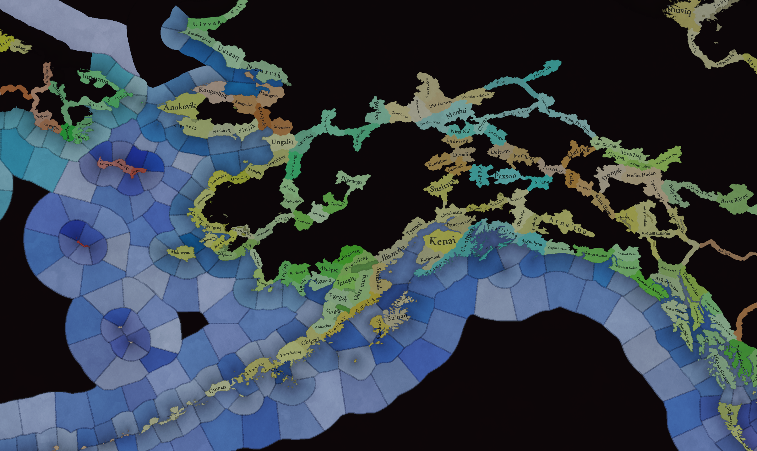
For today’s Tinto Maps, we thought it would be a good idea to show both the land-owning countries and the SoPs. As I commented last week, we’re trying to follow consistent criteria to categorize countries and societies. This is our current proposal for North America, with Cahokia and some Pueblo people being the only regular countries in 1337, surrounded by numerous SoPs. I’m not bothering to share the Dynasty mapmode, as we don’t have any clue about them, and they’re auto-generated.

However, we have been reading and considering the feedback we received last week, in the Tinto Maps for Oceania, so we want to let you know that this is our current design proposal and that we want to hear from you what are your expectations regarding the countries that you would consider landed in 1337*, and also which countries you’d like to play with in this region, either as landed, or as a SoP.

As you may already know, our commitment is to make Project Caesar a great, fun game with your help, and we greatly appreciate the feedback we receive from you in that regard.

* This is already quite tricky, as most of our information only comes from post-1500s accounts when the native societies were already looking very different from two centuries ago. Eg.: The first reports made by Hernando de Soto about the Coosa Chiefom around 1540 points it out to be organized in a way that we’d consider it a Tribal land-owning tag, as confirmed by archaeology. However, that polity was not organized at that level of complexity in 1337, as there isn’t any contemporary data comparable to that of Cahokia. And some decades after the encounter with de Soto and some other European explorers, the mix of diseases had made the Chiefdom collapse, being more akin to what a SoP would be. This type of complex historical dynamism is what makes it so difficult to make the right call for the situation in 1337, and also for us to develop with our current game systems the proper mechanics that would be needed for SoPs to be fully playable (and not just barely half-baked).


Locations:
Locations.png

Locations2.png

Locations3.png

Locations4.png

Locations5.png

Locations6.png

Locations7.png

Locations8.png

Locations9.png

Locations10.png
Plenty of locations, at the end of the day, are a big sub-continent… You may notice that we’ve tried to use as many native names as possible, although sometimes, we’ve failed to achieve that. Any suggestions regarding equivalences of Native and Post-Colonial will be very much appreciated, as this is a huge task to do properly!

Provinces:
Provinces.png

Provinces2.png

Provinces3.png


Areas:
Areas.png

Areas2.png

Areas… And with them, an interesting question that we’d like you to answer: Which design and style do you prefer, that of the East Coast, more based on the Colonial and Post-Colonial borders? Or the one for the Midwest and the Pacific Coast, more based on geography, and less related to attached to modern states? Just let us know!

Terrain:
Climate.png

Topography.png

Topography2.png

Vegetation.png

Some comments:
  • Most climates are portrayed in NA, from Arctic to Arid.
  • The Rocky Mountains are rocky!
  • Regarding vegetation, we wanted to portray the forest cover in 1337, which is tricky, and that’s why some areas may look too homogeneous. Any suggestions are welcome!

Development:
Development.png

Not a very well-developed region in 1337…

Natural Harbors:
Harbors EC.png

Harbors WC.png

Harbors3.png


Cultures:
Cultures.png

Cultures1.png

Cultures2.png

Cultures3.png

Lots of cultural diversity in NA!

Languages:
Languages.png

And the languages of those cultures!

Religions:
Religions.png

Religions2.png

We have a mixed bag here: On the one hand, Eastern and Northern religions look more like the design we’re aiming to achieve, while on the other, to the south, you can find the splitter animist religions based on cultures that we now want to group into bigger religions, more akin to the northern areas.

Raw Materials:
Raw Materials.png

Raw Materials 2.png

Raw Materials3.png

Wild Game, Fish, and Fur are king in this region! But we are also portraying the ‘three sisters’ (maize, beans, squash), the agricultural base for many of the native American societies, using Maize, Legumes (beans), and Fruit (squash). Cotton is also present in the south, as it was also native to the region (although the modern variant comes from a crossing with the ‘Old World’ one), and there are also mineral resources present here and there.

Markets:
Markets.png

Two markets are present in 1337, one in Cahokia, and another in the Pueblo land.

Population:
Broken map! But as this is an interesting topic to discuss, these are the current numbers we’ve got in the region:
  • Continent:
    • 20.487M in America (continent)
  • Sub-continents:
    • 10.265M in North and Central America (we have a pending task to divide them into two different sub-continents)
    • 10.222M in South America
  • Regions (roughly 1.5M):
    • 162K in Canada
    • 1.135M in the East Coast
    • 142K in Louisiana
    • 154K in the West Coast
    • 43,260 in Alaska

And that’s all for today! There won't be a Tinto Maps next week, as it's a bank holiday in Spain (as I was kindly reminded in a feedback post, you're great, people!), so the next one will be Central America on December 13th. But, before that, we will post the Tinto Maps Feedback review for Russia on Monday, December 9th. Cheers!
 
  • 184Like
  • 49Love
  • 20
  • 7
  • 7
Reactions:
Resident Masshole here with a few minor suggestions:

Locations3.png

The Poctumtuck Range is not particularly imposing, aside from a few prominent - and isolated - peaks near the Connecticut River, and certainly isn't impassible. It is represented adequately by the overall 'hills' topography of the area.

Harbors EC.png

The natural harbors are my biggest area of objection. Cape Cod should not be a good harbor. Though it may look like a good protected area like the Long Island Sound, the inner shore is far too beachy and shallow for docks, while the outer shore has only minor inlets for coastal traffic. The only significant harbor on it is Provincetown (in blue), which is too remote to be significantly developed. More significant, and unrepresented, natural harbors are circled in red. From east to west, they are Plymouth, New Bedford, and Providence.

Plymouth is nice and protected, though very shallow. It was, however, potent enough to form the first colony in the area.

New Bedford developed into a major whailing town in the later parts of the game's timeframe, and remained one of the whaling capitals of the world through the mid 1800s.

Providence is a very good, well-protected harbor. Historically, it never reached its full potential due to its proximity to the already established Boston Harbor, though, in an alternate history, it could've realistically outperformed Boston.
# -25 - Cliffs - South of Chile
# 0 - Flat Coast - Barcelona
# 25 - Bay - Palma de Mallorca
# 50 - River Port - Sevilla
# 75 - Deep Bay - San Sebastián
#100 - Closed Very Defensible Estuary - Ferrol
By these standards, if Boston Harbor is a 100, I'd suggest for Cape Cod - 0, Plymouth - 25, New Bedford - 50, and Providence - 100.

Topography2.png
Untitled.png

If you're looking for a bit more variety in topography, much of the southeastern part of the state, is quite marshy, and pockmarked with small ponds and wetlands which were historically converted into cranberry bogs. This region covers the southern portions of the Patuxet and Assonet locations, and so neither if 'fully' wetlands, both could be converted to wetlands, though I would recommend just Patuxet be.

oxkebar6shac1.jpeg

In terms of vegetation, we can see that basically the whole of New England, is covered in closed-tree forests, aside from a few patchy areas in southeastern Massachusetts, and what is now a significant agricultural area in western Vermont. Essentially, the whole of New England should be classified as forest, aside from perhaps Patuxet, if variety is desired.

Lastly, though it is true that the local natives relied heavily on the New World staple crops, this was only sufficient to sustain their smaller population. New England has very poor quality soil, so large scale commercial farming was not possible. The major raw materials produced by the colonies were lumber, game, furs, and fish/whales. The whole southern coastline producing maize is not accurate. I would recommend Patuxet, Assonet, Nauset, and Nantucket be converted to fish. Lumber is pretty underrepresented, so the remaining maize could be converted to lumber, as well as a few of the wild game and fur locations.
 
Last edited:
  • 15Like
  • 3
  • 2
Reactions:
Some ideas regarding the Pacific Northwest:

Terrain: As many others have said, the whole region should be far more mountainous. The North Cascades are anything but flatlands!

Climate: The eastern shores of Puget Sound/the Salish Sea in real life have a warm-summer Mediterranean climate by the Koppen classification, which I believe in some previous Tinto Maps has been lumped in with Oceanic. Oceanic would definitely be more appropriate than Continental, since the area is famous for having a relatively mild and damp climate.

Locations: Overall, I am impressed with the pretty high density of locations. I might make some more detailed feedback later, but for now here are a few thoughts:
- Renaming the location currently called "Puyallup" to "Duwamish" would probably make more sense. The Puyallup certainly are from the southern part of the location, but most of it lines up with areas inhabited by the Duwamish, and the location includes the modern-day city of Seattle, which is, of course, the biggest city in the region and is named for a Duwamish chief.
-Alternatively, Puyallup could be split in two with the northern piece being named "Duwamish," and the southern piece keeping the Puyallup name and including current-day Tacoma and the Puyallup River basin.
- For satisfying borders' sake, I would suggest using the Columbia River as a boundary between locations and reworking locations with land on both sides of the river, like Clatsop and Multnomah.
- The location including the San Juan Islands and a sliver of mainland between Bellingham Bay and Boundary Bay looks very strange to me, seeing as the location is like half island but still is connected by land to other locations. Though I admit it would be very small, perhaps splitting off the San Juan Islands as their own location would be better. Some of the Gulf Islands (which are essentially just the part of the San Juans that extend past the Haro Strait into Canada) could be included in this new insular location to make it a bit less tiny.

Societies of Pops: Also as other commenters have pointed out, there is a good argument to be made that the coastal peoples of the Northwest would meet the requirements for being included as Societies of Pops.
 
  • 4Like
  • 2
Reactions:
I don't think my thoughts on this will come as a surprise to anyone that has followed my activity in the forums!

ive-been-looking-forward-to-this-dooku.gif


Firstly, good job on all the work on the map, especially for the locations. I found out how hard it can be to find native names for some areas so even this much is fairly good, much better than my recent attempts!

Current Settled Countries:

Puebloans:

I like that we got at least a few Puebloan tags! For those who don't know:

- Acoma Pueblo = Áakʼu
- Teypana is the same
- Pueblo of Isleta = Shiewhibak
- Zia Pueblo = Tsi'ya
- Sandia Pueblo = Tuf Shur Tia
- Pueblo Galisteo = Than-u-ge
- Ohkwee Ówîngeh is the same and was formerly known as San Juan Pueblo
- Taos Pueblo = Iałopháybo

For the area immediately around the north New Mexican Pueblos, I feel like you could add locations for some of the other local Pueblos like Cicuye, Kawaika, Kua-Kaa, Puye, etc.


Cahokia:

Of course I'm glad that we got Cahokia, the poster child for North America at this time! As an interesting tidbit that may be worth knowing, according to recent research, after its abandonment around 1350-1400, Cahokia did get a population rebound by 1500 until declining again around 1700. Another cool thing to know about Cahokia is that, before their decline they used to have colonies/missions further afield in places such as Aztalan, Trempealeau, etc.!

As hard as it might be for some to believe for a struggling country, I'd actually make Cahokia a little bit bigger here. Firstly, with the American Bottom being the core area of Cahokia, owning the nearby Pulcher site and Emerald Mounds, and possibly owning the Ware Mounds for the valuable chert close by, I'd at least include the Kaskaskia, Kaskankaham, Chepoussa, and Ochechiton locations to Cahokia.

cahokia emerald.jpg


Another area I'd add to Cahokia is the Missouri river up to where modern Kansas City and St. Joseph are. This would add the locations Nudarcha, Wimihsoorita, and Nodaway. In this area is where the Steed-Kisker culture is. According to the Wikipedia page:

"Initially, numerous Cahokia-style projectile points were found here, and a trading link was theorized. But more recently, other evidence, such as "wall trench house construction, quantification of non-local trade materials", and evidence of two temple mound communities on the lower Missouri River (which were destroyed, used for fill in railroad development in the 19th century) have indicated more direct relations and early settlement by people from Cahokia.[2]"

One last area I'd add to Cahokia is the Illinois River up to the Fendel Site. Its near the Peoria, Illinois so we'd include the Peoria location.


cirv cahokia.jpg


Settled Countries that I'd add:

As I'm sure you're aware of by now, most of us in these forums think that more Settled Countries should be added to North America.

Southwest:

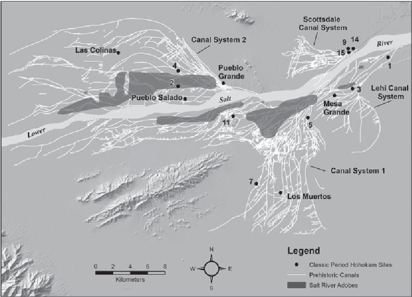
The biggest contender that I'd want for this region would be the massive Hohokam community that farmed along the Salt and Gila river valleys. As I mentioned in a thread about the Southwest, the Hohokam in this area built massive multistory settlements to house thousands of people, had their own ballcourts, and constructed numerous irrigation canals to feed their large population which is estimated at 50,000 to 60,000 in each close river valley. Under one polity, that's a population of around 120,000! As others have said, you may want to adjust that "154K in the West Coast" number. Some of the largest sites in this area are Pueblo Grande (S’edav Va’aki) in Phoenix, Pueblo Los Muertos in Tempe, and Casa Grande (Siwañ Waʼa Ki) at the Gila River. In my maps, I put Pueblo Grande as the capital of the 2 river valleys but you're welcome to take a look and make that determination yourself. Also, in Akimel O'odham oral traditions, it is mentioned that "before the appearance of the Coyote People appeared, this massive structure was built by an important chieftain called Sial Teu-utak Sivan, (turqoise Leader) or "Chief Turquoise". In the ancient hohokam language, the great house and the associated prehistoric ruins found north of Coolidge were collectively referred to as Sivan Vah'Ki, literally meaning the "Abandoned House", or "Village of the king/chieftain", respectively. As Frank Russell recorded in the early 20th century, several O'odham oral traditions note that Sial Teu-utak was an important leader of the Casa Grande community, before the overthrow of the Suwu'Ki O'odham, or "Vulture People"."

It sounds settled to me!

pueblo grande.png

phoenix canals.png

hohokam area.png

hohokam sites.png


This post is getting...a bit long so I'll submit this one and put in a part 2 momentarily!
 
Last edited:
  • 13Like
  • 6
  • 5
  • 2Love
Reactions:
Should provide sources, and also bear in mind that not everyone agrees with every population estimate

Yeah. Considering that the Spanish only really colonized California in 1790ish, and by 1860 there were basically no natives left in the state, it’s hard to believe it could be quite so populated.

This all goes to the central difficulty with modelling native populations, irl or in game. We really have no idea of numbers outside of Virginia. Everything is at best a guesstimate, and generally infused with a heavy dose of politics
 
  • 3
Reactions:
For today’s Tinto Maps, we thought it would be a good idea to show both the land-owning countries and the SoPs. As I commented last week, we’re trying to follow consistent criteria to categorize countries and societies. This is our current proposal for North America, with Cahokia and some Pueblo people being the only regular countries in 1337, surrounded by numerous SoPs. I’m not bothering to share the Dynasty mapmode, as we don’t have any clue about them, and they’re auto-generated.

However, we have been reading and considering the feedback we received last week, in the Tinto Maps for Oceania, so we want to let you know that this is our current design proposal and that we want to hear from you what are your expectations regarding the countries that you would consider landed in 1337*, and also which countries you’d like to play with in this region, either as landed, or as a SoP.

Arizonan here, I'm going to give a bit of feedback about the O'odham (and I know from a previous SW thread there may be more from others).

First off, I would absolutely love to play as the O'odham, though I don't know that they were any more 'settled' than other regional SOPs, particularly in the 14th century. However we can make that happen I'm into and willing to help out. And North America should definitely follow geographic boundaries over colonial ones. So feedback:

SoPs SW.png
Can we get a zoom here? Or a list of the names? I can't read the smaller ones other than Akimel and Tohono. It looks like the grey may represent the Cocopah (Xawiƚƚ kwñchawaay) but their territory should NOT extend East from the Colorado River, rather it should be culturally and politically O'odham, though few people lived there at all.

SPELLING
There is a lot of inconsistency here (including Wikipedia) so I'll try to recommend a standard orthography for things

Locations SW.png
I understand why you named the locations after groups, but I have some potential alternatives for the O'odham ones. My source is O'odham Place Names by Harry Winters, as well as A Tohono O'odham Grammar and Tohono O'odham to English Dictionary by Ofelia Zepeda). If the location density ever increases I can provide a lot more specific suggestions.
  • North Hia-Ceḍ O'odham->
    • If unchanged should be spelled "Hiach'eḍ O'odham"
      • "C" in this context is pronounced as the English "ch", and "ḍ is a retroflex
    • "Kaav 'Onga"
      • after an O'odham camp near the Gulf of California, literally "Badger's Salt"
      • This camp was small but extremely valuable as pilgrimages to gather salt were and are spiritually/materially important to the O'odham
    • "Hiach'eḍ Wahwia"
      • after a small town in the region, literally "Town in the Dunes"
  • South Hia-Ceḍ O'odham->
    • There is honestly not much going on here
    • Vi'ishañik
      • literally "shallow gully"
      • Village about 20 miles west of modern-day Caborca, Sonora
      • Attested to in 1694 by Father Kino's expedition
    • Ge Kaachk Baasho
      • Coast of the Gulf of California, literally "Breast of The Great Expanse"
  • Hu:huhla->
    • If unchanged should be spelled "Huhhu'ula"
      • this is to maintain consistency with "O'odham", where the apostrophe signifies a glottal stop
    • Chuchk Dodo'ag
      • literally "Black Mountains" after all the basalt mountain ranges along this territory
    • Ali Jeg
      • after a strategic town close to the modern US/Mexico border
      • literally "Small Pass/Opening" in between two mountain ranges,
  • Koklolodi->
    • Waw Giwulk
      • this is the absolute center of O'odham history and spirituality, where the ancestor-god The I'itoi led the O'odham people out from the underworld and into their homeland
      • this part of the modern day reservation is still named after the mountain, in Spanish/English "Baboquivari"
  • Akimel O'odham->
    • Akimeḍ (a variant of "Akimel", both meaning river but Akimeḍ may distinguish it from the people)
  • Totokwañ->
    • Chuk Ṣon
      • modern-day Tucson, Arizona
      • literally "at the base of the black mountain"
      • even then a population center, relatively speaking
      • will have the most continuity with later centuries
    • Ge Aji Do'ag
      • literally "Big Peak Mountain"
      • Ceremonially important to the northern Tohono O'odham
  • Tohono O'odham->
    • This name as-is is pretty unacceptable, the various O'odham of the region are collectively "Tohono O'odham" so this makes no sense
    • Hugidag
      • literally "boundary"
      • potentially called such because it was in-between the lands of the Sobaipuri (Sobas to the Spanish) and other unnamed Piman peoples
      • somewhat unclear origin, but reconstructed from a town the Spanish called "Uquitoa"
  • Himuris
    • Probably fine given they gave their name to modern-day Imuris, Sonora
    • Wegi Vav
      • modern-day Magdalena, Sonora
      • literally "Red Outcropping"
      • Attested to by Father Kino in 1694
  • Sobaipuri
    • This region is probably too far North and East, but given the lack of records it's probably fine
    • No place names I can find for this region :(
Cultures SW.png
As I said earlier it makes no sense that the Cocopah extend East across the northern Gulf of California, and should instead be culturally O'odham.

Speaking of O'odham, the name "Othama" is literally just a dialect/spelling variation on O'odham (along with "Aatam") and for consistency's sake should just be "O'odham". Alternatively "Pima" or "Piman" is acceptable, as there were many subgroups (including the exclave of Pimans in-between the Seri and Opata shown here)

Areas SW.png
It's a bit strange to call Arizona/western New Mexico Shiewhibak, as that only seems to ever have referred to a small Pueblo town. Instead you might use "Ali Shon" or "Ali Shonak" meaning "Little Spring" from which we get the name Arizona.

It is likewise a little strange to see a small island (Tahejoc) be used as a replacement for all of Sonora, but I don't have great suggestions. As I suggested for locations you might try "Ge Kaachk Baasho", meaning "Coast of the Gulf of California", literally "Breast of The Great Expanse" in O'odham.

Languages SW.png
I actually really like "Yutonahau" as a pre-Columbian name for Uto-Aztecan. Looking forward to seeing dialects.

That's all my feedback for now, please let me know if I can help more/whether this helped at all!
 
Last edited:
  • 9Like
  • 3
  • 1Love
Reactions:
I cannot see Canada on the population map - so maybe it's only missing from the nation map but make sure the mi'kmaq peoples are present in the maritimes in Canada :)
 
  • 1
Reactions:
Here is some post-contact estimates of First Nations and Inuit populations in Canada (and parts of the United States) from the 18th and 19th centuries. Note that these are period sources so they do not use modern names or terminologies. Given that these numbers come after a century or two of disease and colonization, the numbers pre-contact were significantly higher.


Given the Canadian government estimated 102 000 First Nations and Inuit in 1871, the number of 162 000 in 1377 is likely too low, especially if the number for Canada includes the Canadian West Coast.
 
  • 5Like
  • 1
  • 1
  • 1
Reactions:
For vegetation in what is now British Columbia, these maps should be quite useful:

Biogeoclimatic Zones of British Columbia

Landcover Classification of British Columbia

Note that the landcover map is contemporary so it shows the effects of settlement and climate change. I spotted one issue with the landcover map - there is a decent sized area south of the Peace River near Dawson Creek that is marked as 'herbland' or 'exposed land' but shows up as 'urban/agricultural' in the land cover insert in the Biogeoclimatic Zones map and as farmland in satellite imaging.
 
  • 4Like
  • 1
Reactions:
I've been to northern Minnesota. Northwest Minnesota is more of a flatland with sparse trees. This could be just due to the fact that settlers deforested but I'm not sure if a forest existed there in the past. And central north Minnesota is practically a wetland. Yeah there are forests and it's pretty hilly in some areas, but there's a lot of wetlands. Also, the Minnesota-Wisconsin border is really hilly especially the further south you go along the border.

I heard a saying that before Europeans arrived, a squirrel could go from the Atlantic coast to the Mississippi river without ever touching the ground.
 
  • 2Like
Reactions:
I can see that the locations, provinces and areas are not limited by contemporary borders, neither colonial administration. So I am not sure if we can start talking about the mexican border areas like Baja California, anyway here we go with some points:
- The use of terms like Aridoamerica is an odd choice when Baja California is the historical complementary name with Alta California (California).
- It is preferable to use native names whenever they are available, the same for provinces but once we reach the area scale historical colonial would be more suitable. Personally my ideal would be to use actual native place names for locations, while provinces could use nation (common identity), of course these are not always available.
- Now here I have a suggestion for the Baja California region.
Baja California 01.png
Baja CaliforniaGuaycuraAnuitiAnuitíSan José del Cabo Anuití
AirapiAirapíNuestra Señora del Pilar de la Paz Airapí
ChiriyaquiChiriyaquíSan Luis Gonzaga de Chiriyaquí
ChillaChilláNuestra Señora de los Dolores del Sur Chillá
CochimiMalibatMalibatNuestra Señora de Loreto Conchó , Misión San Juan Bautista Malibat y Ligüí
ComonduComondúSan José de Comondú
CadegomoCadegomóLa Purísima Concepción de Cadegomó
MulegeMulegéSanta Rosalía de Mulegé
CadacamanCadacamánSan Ignacio Cadacamán
CalmalliCalmallíSanta Gertrudis La Magna
AdacÁdacSan Francisco Borja de Ádac
CalamajueCalamajuéSanta María de los Ángeles
ViñadacoViñadacoNuestra Señora del Santísimo Rosario de Viñadoco , San Fernando Rey de España de Velicatá
KumiaiKiliwaKiliwa
ÑakipaÑakipaSanto Domingo de la Frontera , San Pedro Mártir de Verona
PaipaiPaipaiSan Vicente Ferrer
TipaiTipaiSanto Tomás de Aquino
KamiaKamiaSan Miguel la Nueva El Descanso
CucapasCucapá
IipaiIipaiSan Diego de Alcalá
 
  • 3Like
Reactions:
Hello everybody, and welcome one more Friday to Tinto Maps, the place to be for map lovers! Today we will be looking at North America, which is very handy, as we can deliver some Thanksgiving turkey maps to our friends from the USA (and Canada)!

But before I get started, let me have a word on some (shameless) promotion. You may know that we in Paradox Tinto have also been in charge of Europa Universalis IV in the past few years. Well, I just want to let you know that there’s currently an ongoing sale on the game, with several discounts on diverse packages, of which outstands the hefty Ultimate Bundle, which includes all the DLCs developed and released by Tinto in the past 3 years (Leviathan, Origins, Lions of the North, Domination, King of Kings, and Winds of Change), and a whole bunch of the older ones. I’m saying this as you may want to support the ongoing development of Project Caesar this way! Here you may find more detailed information, and all the relevant links: https://forum.paradoxplaza.com/foru...toria-bundle-up-for-this-autumn-sale.1718042/

And now, let’s move from the Black Friday sales to proper Tinto Maps Friday!

Countries & Societies of Pops:
View attachment 1223538
View attachment 1223539
For today’s Tinto Maps, we thought it would be a good idea to show both the land-owning countries and the SoPs. As I commented last week, we’re trying to follow consistent criteria to categorize countries and societies. This is our current proposal for North America, with Cahokia and some Pueblo people being the only regular countries in 1337, surrounded by numerous SoPs. I’m not bothering to share the Dynasty mapmode, as we don’t have any clue about them, and they’re auto-generated.

However, we have been reading and considering the feedback we received last week, in the Tinto Maps for Oceania, so we want to let you know that this is our current design proposal and that we want to hear from you what are your expectations regarding the countries that you would consider landed in 1337*, and also which countries you’d like to play with in this region, either as landed, or as a SoP.

As you may already know, our commitment is to make Project Caesar a great, fun game with your help, and we greatly appreciate the feedback we receive from you in that regard.

* This is already quite tricky, as most of our information only comes from post-1500s accounts when the native societies were already looking very different from two centuries ago. Eg.: The first reports made by Hernando de Soto about the Coosa Chiefom around 1540 points it out to be organized in a way that we’d consider it a Tribal land-owning tag, as confirmed by archaeology. However, that polity was not organized at that level of complexity in 1337, as there isn’t any contemporary data comparable to that of Cahokia. And some decades after the encounter with de Soto and some other European explorers, the mix of diseases had made the Chiefdom collapse, being more akin to what a SoP would be. This type of complex historical dynamism is what makes it so difficult to make the right call for the situation in 1337, and also for us to develop with our current game systems the proper mechanics that would be needed for SoPs to be fully playable (and not just barely half-baked).


Locations:
View attachment 1223545
Plenty of locations, at the end of the day, are a big sub-continent… You may notice that we’ve tried to use as many native names as possible, although sometimes, we’ve failed to achieve that. Any suggestions regarding equivalences of Native and Post-Colonial will be very much appreciated, as this is a huge task to do properly!

Provinces:
View attachment 1223555
View attachment 1223556
View attachment 1223557

Areas:
View attachment 1223558
View attachment 1223559
Areas… And with them, an interesting question that we’d like you to answer: Which design and style do you prefer, that of the East Coast, more based on the Colonial and Post-Colonial borders? Or the one for the Midwest and the Pacific Coast, more based on geography, and less related to attached to modern states? Just let us know!

Terrain:
View attachment 1223560
View attachment 1223561
View attachment 1223562
View attachment 1223563
Some comments:
  • Most climates are portrayed in NA, from Arctic to Arid.
  • The Rocky Mountains are rocky!
  • Regarding vegetation, we wanted to portray the forest cover in 1337, which is tricky, and that’s why some areas may look too homogeneous. Any suggestions are welcome!

Development:
View attachment 1223565
Not a very well-developed region in 1337…

Natural Harbors:
View attachment 1223566
View attachment 1223567
View attachment 1223568

Cultures:
View attachment 1223569
View attachment 1223570
View attachment 1223571
View attachment 1223572
Lots of cultural diversity in NA!

Languages:
View attachment 1223573
And the languages of those cultures!

Religions:
View attachment 1223574
View attachment 1223575
We have a mixed bag here: On the one hand, Eastern and Northern religions look more like the design we’re aiming to achieve, while on the other, to the south, you can find the splitter animist religions based on cultures that we now want to group into bigger religions, more akin to the northern areas.

Raw Materials:
View attachment 1223576
View attachment 1223577
View attachment 1223578
Wild Game, Fish, and Fur are king in this region! But we are also portraying the ‘three sisters’ (maize, beans, squash), the agricultural base for many of the native American societies, using Maize, Legumes (beans), and Fruit (squash). Cotton is also present in the south, as it was also native to the region (although the modern variant comes from a crossing with the ‘Old World’ one), and there are also mineral resources present here and there.

Markets:
View attachment 1223579
Two markets are present in 1337, one in Cahokia, and another in the Pueblo land.

Population:
Broken map! But as this is an interesting topic to discuss, these are the current numbers we’ve got in the region:
  • Continent:
    • 20.487M in America (continent)
  • Sub-continents:
    • 10.265M in North and Central America (we have a pending task to divide them into two different sub-continents)
    • 10.222M in South America
  • Regions (roughly 1.5M):
    • 162K in Canada
    • 1.135M in the East Coast
    • 142K in Louisiana
    • 154K in the West Coast
    • 43,260 in Alaska

And that’s all for today! There won't be a Tinto Maps next week, as it's a bank holiday in Spain (as I was kindly reminded in a feedback post, you're great, people!), so the next one will be Central America on December 13th. But, before that, we will post the Tinto Maps Feedback review for Russia on Monday, December 9th. Cheers!
So... what happened to all of the tribes of the Pacific Northwest? There are many with large and settled populations with archaeological evidence going back ten thousand years.

I can provide a little help there. Quuiich is the autonym of one of the tribes of the Southern Oregon Coast (who lived slightly to the east); it is not a geographical term. That location should be called "Kuukus", and was inhabited by the Hanis people (which should be a SoP). Kuukus should have a very good harbor-- the Port of Coos Bay is the largest and deepest port between San Francisco and Seattle, and was for fifty years the largest lumber-exporting port in the world (outside of PC's timeframe, but that should give you a sense of the harbor's potential). A little to the north, the location Yaquina should be inhabited by the Siuslaw people (as another SoP), and should possess a substantially better harbor than it does, as it has the Oregon Coast's other deepwater harbor (though not as good as the Kuukus harbor; the modern-day town of Newport's harbor is significantly smaller and shallower than Coos Bay's).

Some sources:

Edit: "Coos" should also be changed to "Hanis" in the culture map. "Coos" just means "south" in the local language.

All of that aside, please ditch the colonial boundaries and stick with the ones that emerge naturally from geography. The colonial ones are way too based on historical contingency, and will feel painfully out of place in the vast majority of games. While you're at it, the Pomo area is way too large (and why is it called Pomo?). It should at least be divided by the Cascade Range, with different areas on either side of the mountains.
 
Last edited:
  • 3
  • 1Like
Reactions:
Yes! And we'd also welcome suggestions regarding this!
Quuiich should be Kuukus to begin with, but it should be renamed Coos Bay when colonized, and Yaquina should be renamed Newport when colonized.
 
  • 1Like
Reactions:
Penobscot Bay should definitely be a natural harbor. It did not develop in this timeline because it was close to the borders of England and France.
Penobscot Bay.png


Castine was an early English colony owing to its convenient location and proximity to plenty of lumber. Oh and the location should change its trade good to lumber.

Penobscot Bay Larger.png
 
  • 3Like
  • 1
Reactions:
These are our current (Spanish-centric) standards, which we're trying to make as viable as possible in the rest of the world:
Ah, good to know. Then Quuiich (which should be Kuukus) has a Closed Very Defensible Estuary (at Coos Bay, with additional river ports at Bandon and Winchester Bay), as does (to a slightly lesser extent) Yaquina (at Newport, with river ports at Florence and Waldport). Tillamook has a Deep Bay (at Tillamook), and Clatsop has a positively massive River Port (at Astoria, the oldest American settlement west of the Rocky Mountains). Tututni has a significant River Port (at Gold Beach, with a smaller one at Sixes), and Chidkhu has two (at Brookings and at Smith River).

So Quuiich (that is, Kuukus) and Yaquina should have 100, Tillamook should have 75, and Clatsop, Tututni, and Chidkhu should have 50.
 
  • 3Like
  • 1
Reactions:
I definitely prefer borders based on geography in the New World! Post-colonial area borders look intensely ugly. Btw, please include the bits and pieces of oceanic climate in the east coast of the US. They should add strategy to the game.
 
  • 6Like
  • 1
Reactions: