• We have updated our Community Code of Conduct. Please read through the new rules for the forum that are an integral part of Paradox Interactive’s User Agreement.

Tinto Maps #28 - 29th of November 2024 - North America

Hello everybody, and welcome one more Friday to Tinto Maps, the place to be for map lovers! Today we will be looking at North America, which is very handy, as we can deliver some Thanksgiving turkey maps to our friends from the USA (and Canada)!

But before I get started, let me have a word on some (shameless) promotion. You may know that we in Paradox Tinto have also been in charge of Europa Universalis IV in the past few years. Well, I just want to let you know that there’s currently an ongoing sale on the game, with several discounts on diverse packages, of which outstands the hefty Ultimate Bundle, which includes all the DLCs developed and released by Tinto in the past 3 years (Leviathan, Origins, Lions of the North, Domination, King of Kings, and Winds of Change), and a whole bunch of the older ones. I’m saying this as you may want to support the ongoing development of Project Caesar this way! Here you may find more detailed information, and all the relevant links: https://forum.paradoxplaza.com/foru...toria-bundle-up-for-this-autumn-sale.1718042/

And now, let’s move from the Black Friday sales to proper Tinto Maps Friday!

Countries & Societies of Pops:
Countries.png

SoPs.png

SoPs2.png

SoPs3.png

SoPs4.png

SoPs5.png
For today’s Tinto Maps, we thought it would be a good idea to show both the land-owning countries and the SoPs. As I commented last week, we’re trying to follow consistent criteria to categorize countries and societies. This is our current proposal for North America, with Cahokia and some Pueblo people being the only regular countries in 1337, surrounded by numerous SoPs. I’m not bothering to share the Dynasty mapmode, as we don’t have any clue about them, and they’re auto-generated.

However, we have been reading and considering the feedback we received last week, in the Tinto Maps for Oceania, so we want to let you know that this is our current design proposal and that we want to hear from you what are your expectations regarding the countries that you would consider landed in 1337*, and also which countries you’d like to play with in this region, either as landed, or as a SoP.

As you may already know, our commitment is to make Project Caesar a great, fun game with your help, and we greatly appreciate the feedback we receive from you in that regard.

* This is already quite tricky, as most of our information only comes from post-1500s accounts when the native societies were already looking very different from two centuries ago. Eg.: The first reports made by Hernando de Soto about the Coosa Chiefom around 1540 points it out to be organized in a way that we’d consider it a Tribal land-owning tag, as confirmed by archaeology. However, that polity was not organized at that level of complexity in 1337, as there isn’t any contemporary data comparable to that of Cahokia. And some decades after the encounter with de Soto and some other European explorers, the mix of diseases had made the Chiefdom collapse, being more akin to what a SoP would be. This type of complex historical dynamism is what makes it so difficult to make the right call for the situation in 1337, and also for us to develop with our current game systems the proper mechanics that would be needed for SoPs to be fully playable (and not just barely half-baked).


Locations:
Locations.png

Locations2.png

Locations3.png

Locations4.png

Locations5.png

Locations6.png

Locations7.png

Locations8.png

Locations9.png

Locations10.png
Plenty of locations, at the end of the day, are a big sub-continent… You may notice that we’ve tried to use as many native names as possible, although sometimes, we’ve failed to achieve that. Any suggestions regarding equivalences of Native and Post-Colonial will be very much appreciated, as this is a huge task to do properly!

Provinces:
Provinces.png

Provinces2.png

Provinces3.png


Areas:
Areas.png

Areas2.png

Areas… And with them, an interesting question that we’d like you to answer: Which design and style do you prefer, that of the East Coast, more based on the Colonial and Post-Colonial borders? Or the one for the Midwest and the Pacific Coast, more based on geography, and less related to attached to modern states? Just let us know!

Terrain:
Climate.png

Topography.png

Topography2.png

Vegetation.png

Some comments:
  • Most climates are portrayed in NA, from Arctic to Arid.
  • The Rocky Mountains are rocky!
  • Regarding vegetation, we wanted to portray the forest cover in 1337, which is tricky, and that’s why some areas may look too homogeneous. Any suggestions are welcome!

Development:
Development.png

Not a very well-developed region in 1337…

Natural Harbors:
Harbors EC.png

Harbors WC.png

Harbors3.png


Cultures:
Cultures.png

Cultures1.png

Cultures2.png

Cultures3.png

Lots of cultural diversity in NA!

Languages:
Languages.png

And the languages of those cultures!

Religions:
Religions.png

Religions2.png

We have a mixed bag here: On the one hand, Eastern and Northern religions look more like the design we’re aiming to achieve, while on the other, to the south, you can find the splitter animist religions based on cultures that we now want to group into bigger religions, more akin to the northern areas.

Raw Materials:
Raw Materials.png

Raw Materials 2.png

Raw Materials3.png

Wild Game, Fish, and Fur are king in this region! But we are also portraying the ‘three sisters’ (maize, beans, squash), the agricultural base for many of the native American societies, using Maize, Legumes (beans), and Fruit (squash). Cotton is also present in the south, as it was also native to the region (although the modern variant comes from a crossing with the ‘Old World’ one), and there are also mineral resources present here and there.

Markets:
Markets.png

Two markets are present in 1337, one in Cahokia, and another in the Pueblo land.

Population:
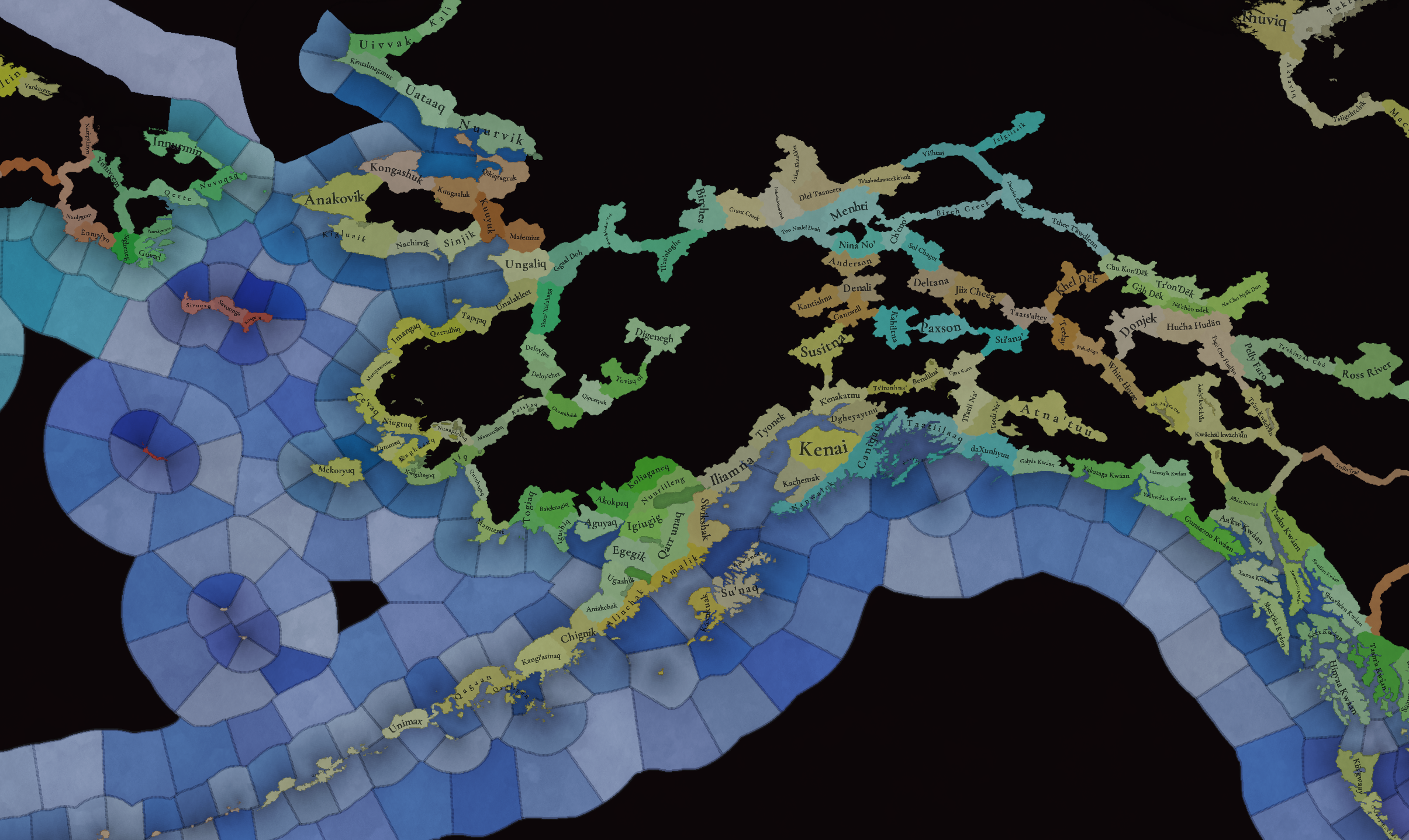
Broken map! But as this is an interesting topic to discuss, these are the current numbers we’ve got in the region:
  • Continent:
    • 20.487M in America (continent)
  • Sub-continents:
    • 10.265M in North and Central America (we have a pending task to divide them into two different sub-continents)
    • 10.222M in South America
  • Regions (roughly 1.5M):
    • 162K in Canada
    • 1.135M in the East Coast
    • 142K in Louisiana
    • 154K in the West Coast
    • 43,260 in Alaska

And that’s all for today! There won't be a Tinto Maps next week, as it's a bank holiday in Spain (as I was kindly reminded in a feedback post, you're great, people!), so the next one will be Central America on December 13th. But, before that, we will post the Tinto Maps Feedback review for Russia on Monday, December 9th. Cheers!
 
  • 184Like
  • 49Love
  • 20
  • 7
  • 7
Reactions:
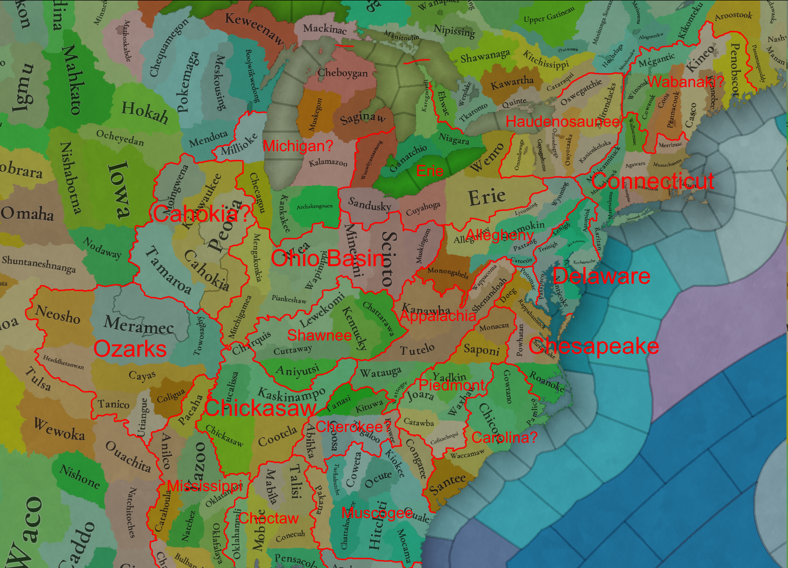
Since there seems to be a strong majority in favor of geographic areas, I decided to draft what that could look like since I haven't seen anyone else put forward any proposals.
Please keep in mind I only followed the province map and some provincial adjustments might be desirable. (Except Kentucky Bend cause that sucks)
I tried to broadly follow geographic regions, then split that up further by cultural regions (Both native and modern american)
Ozarks in particular should not be any different from this, if geographic boundaries are whats being designed for.
1733039741123.png
 
  • 22Like
  • 5
  • 4
  • 1Love
Reactions:
How is it european logic when those were the state borders of an american state, the USA?

I'm pretty convinced now that the only reason why there is so much hate against the historical state borders in the east is just straight-up anti-american bias.
One person here even admitted in a comment that they don't want to see those borders because it reminds them of american exceptionalism and manifest destiny.

This thread is also a perfect case example for how people who post in these map threads don't necessarily represent the player base. This thread makes it sound like everyone loves to play as native americans, wants as many settled states at the start here as possible and hates anything related to colonialism.

But I guarantee you that among the millions of people who will actually play the finished game, the representation of history such as the first settlements on the east coast, the american frontier, the relationship of colonies to the motherland, the american revolution, the louisiana purchase, the expansion into former buffer territory, and yes, recreating historical borders, will garner way more interest than actually playing as native americans in 1337.

I have been farming dislikes in this thread since it came out, but maintain that there is nothing wrong with the state borders and that they should be represented in the game.
The border between France and Belgium was drawn arbitrarily, even though there are many nearby rivers that could have been used as border. It also ignores the historical borders of Flanders. Nobody complained in the relevant thread that this border is "unnatural" and should be changed in the game.
The same can be said about the border between the Netherlands and Germany. I mean, why doesn't it just follow the Ems? Wouldn't that be an obvious natural border? Should the game remedy this historical mistake?
The border could have been drawn a million different ways throughout hundreds of years of history, so should the game not represent how it actually ended up?

The fact that people are arguing for historical borders not to be represented in the game because they don't like how they look is completely absurd. Nobody made comments like this in other map threads. And that's why I have come to the conclusion that there is a lot of bias involved.

I mean, this is a bit of a silly comment. The USA was a creation of Europeans and European states that declared independence towards the end of this game's timeframe. Yes, within the context of this timeframe the behaviour of Americans during this time relative to the American continent could be described broadly as European. Americans prior to the Revolution would have considered themselves British, and would have been keenly aware of that connection after it.

It also isn't anti-American bias, for which there is no evidence of anyone having. The primary factors are the anachronistic nature of the borders, and the lack of consistency with other areas of the world. The straight lines are particularly bad in terms of anachronism as they don't just not reflect how areas would have been at the earlier part of the timeframe, they don't reflect the logic of how areas were defined. Things like the European borders you mentioned may have anachronisms in the first sense, but at least behave in the way these things were defined. I think if the southern border of Germany was defined by the 48th parallel north in game you would find some similar displeasure.

You mention people how 'hate anything related to colonialism' - I disagree with this. My preferred approach would be to have more 'natural' borders pre-European contact, but the in-game process of colonisation re-defines borders, imposing a new logic upon the areas colonised. This is what actually happened, and was a part of what colonisation actually was. I would love to see this in game, and would allow for the US to be re-created if desired. But it would also allow for France or Spain or the Netherlands or someone else to colonise it differently. Obviously this would take development resources and may not be feasible in the near future, but it is what actually happened.

You say 'people are arguing for historical borders not to be represented in the game because they don't like how they look is completely absurd', but the history covered here is 500 years, for which these 'historical' borders only exist for the last part - some for only the last few years. Why are the borders of 1837 more important than 1337 here? Because we have a map of the time? Why not in Australia then, or other areas being colonised in 1837 (Africa, India)? Nobody raised these issues in those threads because the issues aren't present - they only appear here in the North America map.
 
  • 18
  • 4
  • 3Like
Reactions:
More of central arkansas should probably be hills. There's a narrow strip of land where the land is relatively flat, (That's where Little Rock and Fort Smith lay), but if northwest Louisiana is hills then this area also should be.
1733040596101.png
 
  • 4Like
  • 1
Reactions:
Why are the borders of 1837 more important than 1337 here?
Because we don't know what borders looked like in 1337, if there even were any?
It would be different if the borders from late in the period weren't the only borders we know of. But since they are, these borders are the ones that should be used.
The USA is European, arguing otherwise is just silly
I mean, this is a bit of a silly comment. The USA was a creation of Europeans and European states that declared independence towards the end of this game's timeframe. Yes, within the context of this timeframe the behaviour of Americans during this time relative to the American continent could be described broadly as European. Americans prior to the Revolution would have considered themselves British, and would have been keenly aware of that connection after it.
The USA, Mexico, Gran Colombia, Brazil, etc. are all American states, not European states. It doesn't matter if they were culturally mostly European. Once they're independent, their borders are American borders.
Someone born in America is American, whether their ancestors came there 12000 years ago or 100 years ago.

I am curious if it has been decided yet or if I missed the discussion, but can we change resources? I say this because I do not see the need to colonize North America for fish, fruit, and clay if that is all I will get out of it. I have seen similar issues in other resource maps where you would think they would be available in resources but only have fish or clay.
According to colonial statistics the most valuable exports (sorted by value in pounds sterling) of the British Continental Colonies in 1770 were:
906638Tobacco
504553Bread and flour
397945Fish
340693Rice
131552Indigo
131467Wheat
128244Lumber
104134Whale Products
91486Furs
67250Iron
66035Beef and pork
64661Potash/Pearlash
60228Horses
57750Deer skins
43376Maize
35299Flax/Hemp
27888Pitch/Tar
26589Naval Supplies
24926Candles
21836Rum
16572Legumes
16503Barrels
14328Cattle

All of these are either already present in large amounts, like fish, lumber or fur, or they were introduced by colonists, such as tobacco, indigo, wheat, rice or livestock, which is something that players will be able to do in the game.
 
  • 8
  • 7Like
  • 1
Reactions:
I have been farming dislikes in this thread since it came out, but maintain that there is nothing wrong with the state borders and that they should be represented in the game.
The border between France and Belgium was drawn arbitrarily, even though there are many nearby rivers that could have been used as border. It also ignores the historical borders of Flanders. Nobody complained in the relevant thread that this border is "unnatural" and should be changed in the game.
The same can be said about the border between the Netherlands and Germany. I mean, why doesn't it just follow the Ems? Wouldn't that be an obvious natural border? Should the game remedy this historical mistake?
The border could have been drawn a million different ways throughout hundreds of years of history, so should the game not represent how it actually ended up?

I find this a compelling argument. If state borders were used in Europe and throughout the rest of the world, then they should be used in colonial nations. If state borders are not used in colonial nations, then state borders should be revised around the rest of the world to focus on geographical features.

Consistency is logical.

I'm pretty convinced now that the only reason why there is so much hate against the historical state borders in the east is just straight-up anti-american bias.
One person here even admitted in a comment that they don't want to see those borders because it reminds them of american exceptionalism and manifest destiny.

Really? Wow, that is childish. I have been skimming this thread, but I am glad that I missed that comment.
 
  • 7
  • 2
  • 1Like
Reactions:
Really? Wow, that is childish. I have been skimming this thread, but I am glad that I missed that comment.
It's this one:
Honestly, I can’t stand those straight-line borders for so many reasons. I only see american exceptionalism and manifest destiny when looking at it.

Would hate to play as natives on this map, or for that matter doing any ahistorical or non railroaded run. Too rigid!!
6 likes and 1 loves.
 
  • 4
  • 3Like
Reactions:
Because we don't know what borders looked like in 1337, if there even were any?
Not only do we know of dozens of native polities, and the area the occupied, but geographical features still exist. They haven't gone away.

Even if you argue for colonial borders, you should dislike the current setup, as it fails to show how the colonies looked in both practice and claims for most of the time period. Since they did followed natural features for the most part.

It doesn't matter if they were culturally mostly European
It does, trying to say otherwise is just being wilfully ignorant.
 
  • 11
  • 4Like
  • 2
Reactions:
Why don't we take a breather folks? We don't need to start pointing fingers at what we suspect other users motives are. Let's try to be respectful and mature please.
 
  • 9Like
  • 2
Reactions:
Not only do we know of dozens of native polities, and the area the occupied, but geographical features still exist. They haven't gone away.
We certainly don't know their borders.
Even if you argue for colonial borders, you should dislike the current setup, as it fails to show how the colonies looked in both practice and claims for most of the time period. Since they did followed natural features for the most part.
Sure, the exact borders of areas can be debated, I personally like borders as late in the time period as possible as this is the "end result", but if some borders were used for the majority of the time period, e.g. Ming borders in China, then it makes sense to use those.
It does, trying to say otherwise is just being wilfully ignorant.
How does culture matter for borders? US borders are American borders because they are determined by an American state. It has nothing to do with the culture of the people living there. Europeans don't determine the borders of the USA.
Why don't we take a breather folks? We don't need to start pointing fingers at what we suspect other users motives are. Let's try to be respectful and mature please.
There is no suspicion needed when the motives are just stated plainly.
 
  • 13
Reactions:
We certainly don't know their borders.
We know enough for the scale project caesar operates. And once again, geographical features are still present as they were. Unless you for some reason believes the US just blew up every single mountain bettween the Delaware and the mississippi.

Sure, the exact borders of areas can be debated, I personally like borders as late in the time period as possible as this is the "end result", but if some borders were used for the majority of the time period, e.g. Ming borders in China, then it makes sense to use those.
This logic of "end result" isnt being used anywhere else on the map, so why should we use it here. I havent seen you complain of "Anti-Australian Bias" in the previous tinto.

And if we were to employ the borders used during the majority of the game, then they should be based on geographical areas, as they were the mainly used borders for both natives and european colonists.
How does culture matter for borders? US borders are American borders because they are determined by an American state. It has nothing to do with the culture of the people living there
The entire state ideology of the US durinf the 18th and 19th century was based on being an European State, they never claimed to be anything other than European.
Europeans don't determine the borders of the USA.
Basically every single state border East of the mississippi was created due to the claims of European colonies. At this point i am sure you are just being disingeneous.
 
  • 11
  • 4
  • 3Like
Reactions:
It's this one:

6 likes and 1 loves.

Ah. Yeah, I just kind of skimmed a lot of those posts that seemed repetitive. I didn't read that one carefully. As an American, it does get my hackles up when anti-American sentiment appears on the forums (as it does at times). Complaining about American exceptionalism and Manifest Destiny certainly sounds anti-American to me (Edit: To clarify, it comes across as this person not wanting to see the United States of America on the map, which is anti-American). I don't think that such posts are appropriate. I will report it. If moderators do remove it, please remove this section of my comment.

The problem is that the game either uses historical state borders or it doesn't. A player can either recreate the 13 colonies/American borders or they can't. When the same choice was confronted elsewhere, it was determined to go with state borders over geographical features. The reason was so that players could create historical states. I don't see why the colonies would be different. I can see the argument for going with geographical features everywhere and throwing historical borders out, but once Paradox started down the path of historical state borders, I think they have to stick with it. Otherwise, you can't create the historical borders in the Americas, which doesn't seem fair to those who want to do so (whether modern Americans or otherwise).
 
Last edited:
  • 14
  • 1Like
Reactions:
I have been farming dislikes in this thread since it came out, but maintain that there is nothing wrong with the state borders and that they should be represented in the game.
The border between France and Belgium was drawn arbitrarily, even though there are many nearby rivers that could have been used as border. It also ignores the historical borders of Flanders. Nobody complained in the relevant thread that this border is "unnatural" and should be changed in the game.
The same can be said about the border between the Netherlands and Germany. I mean, why doesn't it just follow the Ems? Wouldn't that be an obvious natural border? Should the game remedy this historical mistake?
The border could have been drawn a million different ways throughout hundreds of years of history, so should the game not represent how it actually ended up?

The fact that people are arguing for historical borders not to be represented in the game because they don't like how they look is completely absurd. Nobody made comments like this in other map threads. And that's why I have come to the conclusion that there is a lot of bias involved.

I find this a compelling argument. If state borders were used in Europe and throughout the rest of the world, then they should be used in colonial nations. If state borders are not used in colonial nations, then state borders should be revised around the rest of the world to focus on geographical features.

Consistency is logical.
A major difference between the borders in Europe and the rest of the old world often not following geographical boundaries and the American colonial borders is that the European non-geographical borders are already historical in 1337. These distinctions already existed then and hence are not out of place.
On the other hand, the colonial borders depend on arbitrary decisions that would not be taken for 200 or more years.

I would be fine with hiding modern-ish (not straight lines, but closer to them) borders on the location-level, cutting through provinces. That way, the borders that came about in our history can be reconstructed, if one so wishes. But the proper provinces should follow geographical features or the borders of tribal lands (which would be the equivalent of the Ems not being the German-Dutch border). Similarly, some modern borders can be hidden in location borders in Europe, rather than strictly following province boundaries.
 
Last edited:
  • 17
  • 4Like
Reactions:
A quick couple of questions first:
1. On one pic, could we get a closer look at all the locations under Cahokia?
2. Could we also get a closer look at the SoPs in Northern Mexico? Some are a bit hard to make out.
3. Could we get the population numbers for Cahokia and the 8 Puebloan countries?
4. For anyone who's more familiar with the Kachina religion, would it make sense for it to be split up as it is currently between the Hopi, Zuni, Keres, and Tanoan?


Since there's a lot I'd like to share about which Settled Countries I think should be added in, I'm looking to do so in a more organized way so the posts won't get too large and will be more presentable.

Regardless, I'd still like to make a strong case to include Paquime as a Settled Country. It's a very important polity in 1337 that served as an important trade link between Mesoamerica and the rest of North America and at the game start it was about to get larger. Around 1340, it was burned in a fire but it was rebuilt with many of its small buildings being rebuilt as multistory apartment buildings! It also had ballcourts, a market area, a room for raising macaws imported from Mesoamerica, an intricate water management system, and a sewage system! A population of 2,000 to 10,000 people may have lived there in the city at one time and it may have possibly had control of territories and sites dozens of miles away.

paquime.png

Paquime-Location-of-room-21-and-burial-23-8-at-Paquime-a-Paquime-site-map-produced-by-S-Ure.png

paquime interior.png

paquime sites.png


A really important thing that I should point out is that Paquime, along with the northern New Mexico Pueblos and the Hohokam polity in the Salt and Gila River valleys, had one of the highest population densities in the American Southwest in the 1300s.

https://www.archaeologysouthwest.org/pdf/arch-sw-v22-no4.pdf

Another interesting bit of info I'd like to share about this area is the high number of ballcourts that have been discovered, especially in the Phoenix and Tucson areas.

1000008614.png
 

Attachments

  • 1000008614.png
    1000008614.png
    452,9 KB · Views: 0
  • 6Like
  • 5
Reactions:
I tried to reflect on these feelings, and understand that many Americans may have a strong preference for the borders to be this way

I'm pretty convinced now that the only reason why there is so much hate against the historical state borders in the east is just straight-up anti-american bias.
I've seen at least three people in this thread say... "As an American I prefer geographical borders..." and let me add myself to that list. As an American I prefer geographical borders. I prefer sandbox games where I can make my own history not get railroaded into doing what England did.

Apart from this, I do also want to say that in regard to location boundaries, I'd appreciate as much as possible tinto considering roughly aligning them wherever reasonable with nonAmerican colonial boundaries as well, historical British divisions, Spanish, french, etc. So there are many possibilities rather than railroaded 1837+west virginia America. Avoid the straight lines though please, I said roughly.

1733056964628.png
1733057017347.png
1733057034675.png
1733057050756.png
1733057070258.png
1733057098912.png
1733057181662.png

Boundaries like these for example
 
Last edited:
  • 15Like
  • 3
  • 1
Reactions:
I've got a question. Can you use ships to traverse lets say from lake superior to lake Huron and then through lake Erie to lake Ontario? Or are all the lakes completely seperated from each other?
 
  • 6Like
  • 1
Reactions:
Since there seems to be a strong majority in favor of geographic areas, I decided to draft what that could look like since I haven't seen anyone else put forward any proposals.
Please keep in mind I only followed the province map and some provincial adjustments might be desirable. (Except Kentucky Bend cause that sucks)
I tried to broadly follow geographic regions, then split that up further by cultural regions (Both native and modern american)
Ozarks in particular should not be any different from this, if geographic boundaries are whats being designed for.
View attachment 1224761
This would come into play if the colonies, when they became federations, could be IOs and thus form their own states, which would not be tied to areas. But it's true that it would be very difficult to repeat the situation in the game as it happened in our timeline, unless the player wants to achieve that.
 
  • 1Like
Reactions:
Could there be a game rule for having endonyms vs exonyms for native americans? I understand the desire to represent them properly but the more recognized names would be good too.
 
  • 8Like
  • 1
Reactions:
I find this a compelling argument. If state borders were used in Europe and throughout the rest of the world, then they should be used in colonial nations. If state borders are not used in colonial nations, then state borders should be revised around the rest of the world to focus on geographical features.
I think the issue is that the US borders aren't particularly "natural". The European borders usually go along rivers or other natural obstacles. So what I think many people agree with is something like this:
1. If the borders look natural enough, use historical province/state borders.
2. If they're too straight and out of place, make up or use alternative borders which abide more to the natural barriers.
 
  • 10
  • 2
  • 1Like
Reactions:
Could there be a game rule for having endonyms vs exonyms for native americans? I understand the desire to represent them properly but the more recognized names would be good too.
I think this has been mentioned before as a game rule that they will have in one of the Tinto Talks... but someone do correct me if I am wrong.
 
  • 2Like
Reactions: