• We have updated our Community Code of Conduct. Please read through the new rules for the forum that are an integral part of Paradox Interactive’s User Agreement.

Tinto Maps #28 - 29th of November 2024 - North America

Hello everybody, and welcome one more Friday to Tinto Maps, the place to be for map lovers! Today we will be looking at North America, which is very handy, as we can deliver some Thanksgiving turkey maps to our friends from the USA (and Canada)!

But before I get started, let me have a word on some (shameless) promotion. You may know that we in Paradox Tinto have also been in charge of Europa Universalis IV in the past few years. Well, I just want to let you know that there’s currently an ongoing sale on the game, with several discounts on diverse packages, of which outstands the hefty Ultimate Bundle, which includes all the DLCs developed and released by Tinto in the past 3 years (Leviathan, Origins, Lions of the North, Domination, King of Kings, and Winds of Change), and a whole bunch of the older ones. I’m saying this as you may want to support the ongoing development of Project Caesar this way! Here you may find more detailed information, and all the relevant links: https://forum.paradoxplaza.com/foru...toria-bundle-up-for-this-autumn-sale.1718042/

And now, let’s move from the Black Friday sales to proper Tinto Maps Friday!

Countries & Societies of Pops:
Countries.png

SoPs.png

SoPs2.png

SoPs3.png

SoPs4.png

SoPs5.png
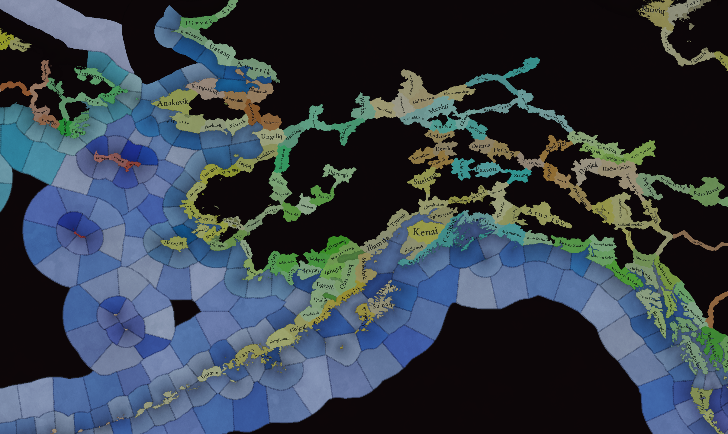
For today’s Tinto Maps, we thought it would be a good idea to show both the land-owning countries and the SoPs. As I commented last week, we’re trying to follow consistent criteria to categorize countries and societies. This is our current proposal for North America, with Cahokia and some Pueblo people being the only regular countries in 1337, surrounded by numerous SoPs. I’m not bothering to share the Dynasty mapmode, as we don’t have any clue about them, and they’re auto-generated.

However, we have been reading and considering the feedback we received last week, in the Tinto Maps for Oceania, so we want to let you know that this is our current design proposal and that we want to hear from you what are your expectations regarding the countries that you would consider landed in 1337*, and also which countries you’d like to play with in this region, either as landed, or as a SoP.

As you may already know, our commitment is to make Project Caesar a great, fun game with your help, and we greatly appreciate the feedback we receive from you in that regard.

* This is already quite tricky, as most of our information only comes from post-1500s accounts when the native societies were already looking very different from two centuries ago. Eg.: The first reports made by Hernando de Soto about the Coosa Chiefom around 1540 points it out to be organized in a way that we’d consider it a Tribal land-owning tag, as confirmed by archaeology. However, that polity was not organized at that level of complexity in 1337, as there isn’t any contemporary data comparable to that of Cahokia. And some decades after the encounter with de Soto and some other European explorers, the mix of diseases had made the Chiefdom collapse, being more akin to what a SoP would be. This type of complex historical dynamism is what makes it so difficult to make the right call for the situation in 1337, and also for us to develop with our current game systems the proper mechanics that would be needed for SoPs to be fully playable (and not just barely half-baked).


Locations:
Locations.png

Locations2.png

Locations3.png

Locations4.png

Locations5.png

Locations6.png

Locations7.png

Locations8.png

Locations9.png

Locations10.png
Plenty of locations, at the end of the day, are a big sub-continent… You may notice that we’ve tried to use as many native names as possible, although sometimes, we’ve failed to achieve that. Any suggestions regarding equivalences of Native and Post-Colonial will be very much appreciated, as this is a huge task to do properly!

Provinces:
Provinces.png

Provinces2.png

Provinces3.png


Areas:
Areas.png

Areas2.png

Areas… And with them, an interesting question that we’d like you to answer: Which design and style do you prefer, that of the East Coast, more based on the Colonial and Post-Colonial borders? Or the one for the Midwest and the Pacific Coast, more based on geography, and less related to attached to modern states? Just let us know!

Terrain:
Climate.png

Topography.png

Topography2.png

Vegetation.png

Some comments:
  • Most climates are portrayed in NA, from Arctic to Arid.
  • The Rocky Mountains are rocky!
  • Regarding vegetation, we wanted to portray the forest cover in 1337, which is tricky, and that’s why some areas may look too homogeneous. Any suggestions are welcome!

Development:
Development.png

Not a very well-developed region in 1337…

Natural Harbors:
Harbors EC.png

Harbors WC.png

Harbors3.png


Cultures:
Cultures.png

Cultures1.png

Cultures2.png

Cultures3.png

Lots of cultural diversity in NA!

Languages:
Languages.png

And the languages of those cultures!

Religions:
Religions.png

Religions2.png

We have a mixed bag here: On the one hand, Eastern and Northern religions look more like the design we’re aiming to achieve, while on the other, to the south, you can find the splitter animist religions based on cultures that we now want to group into bigger religions, more akin to the northern areas.

Raw Materials:
Raw Materials.png

Raw Materials 2.png

Raw Materials3.png

Wild Game, Fish, and Fur are king in this region! But we are also portraying the ‘three sisters’ (maize, beans, squash), the agricultural base for many of the native American societies, using Maize, Legumes (beans), and Fruit (squash). Cotton is also present in the south, as it was also native to the region (although the modern variant comes from a crossing with the ‘Old World’ one), and there are also mineral resources present here and there.

Markets:
Markets.png

Two markets are present in 1337, one in Cahokia, and another in the Pueblo land.

Population:
Broken map! But as this is an interesting topic to discuss, these are the current numbers we’ve got in the region:
  • Continent:
    • 20.487M in America (continent)
  • Sub-continents:
    • 10.265M in North and Central America (we have a pending task to divide them into two different sub-continents)
    • 10.222M in South America
  • Regions (roughly 1.5M):
    • 162K in Canada
    • 1.135M in the East Coast
    • 142K in Louisiana
    • 154K in the West Coast
    • 43,260 in Alaska

And that’s all for today! There won't be a Tinto Maps next week, as it's a bank holiday in Spain (as I was kindly reminded in a feedback post, you're great, people!), so the next one will be Central America on December 13th. But, before that, we will post the Tinto Maps Feedback review for Russia on Monday, December 9th. Cheers!
 
  • 184Like
  • 49Love
  • 20
  • 7
  • 7
Reactions:
As a native Kentuckian, it's weird to see no tobacco in the state, even though it was grown there in pre-colonial times and is still one of the biggest cash crops in the state.

I would also suggest you have further Mississippian states outside of Cahokia. as the mound-building cultures included areas much further south along the Mississippi River, and into the lower Ohio and Tennessee River valleys, and were as complex, though not quite as big, as the Cahokia polity. Moundville in Alabama should absolutely be its own polity, as it's second only to Cahokia in size. Ocmulgee and Etowah in Georgia should be as well. The Kincaid set of Kincaid Mounds (on the Ohio across from the mouth of the Tennessee), Wickliffe Mounds (at the junction of the Ohio and Misssissippi, and Angel Mounds (near where the Green River meets the Ohio) should either be one or three states.
 
  • 3
  • 2Like
Reactions:
Probably a stupid question, but what are those two large impassable areas, 150km west of the Appalachians in both Kentucky en Tennessee?

View attachment 1223608

That's a very good question! That area of south-central Kentucky is just rolling hills, with nothing impassable about them whatsoever. I'm less familiar with that area of Tennessee, but I believe it's similar terrain.

(The big impassible blob in southeastern Kentucky and southern West Virginia is just fine though; that area is just a tangle of mountains and convoluted valleys, and remains much less accessible to outside areas even today, although Kentucky at least is valiantly constructing highways through the mountains to better open it up)
 
  • 1Like
Reactions:
As for the colonial boundaries, keep 'em in. There's not much that can be done about it now, and creating alternate ones will be tough and harder to have a historical basis.
 
  • 4
Reactions:
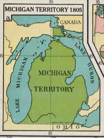
Michigan's UP was the result of inter-state rivalries, but Florida's panhandle is nothing of the sort. That's from Spanish colonial times, when the colony went from Pensacola in the west to St Augustine in the east. The oddity that was added on to Florida later is actually central and southern Florida.
Technically, it's also incorrect to say that Michigan including land above the Straits of Mackinac is a result of interstate rivalries. The land on the north side of the Straits was already part of Michigan before that time, and in fact has never been separated from Michigan at any point since it originated as a territorial entity in 1805. The land that was transferred to it when it gained statehood was actually the western two-thirds of the UP. I would personally argue that this is not random, it is because the Straits of Mackinac were and are a major transport nexus in the Great Lakes.

Regardless, there is a limit to the productivity of noodling endlessly about border changes at the end of the game timeframe.

1733100050613.png


1733099984084.png


1733099956716.png

https://collections.lib.uwm.edu/digital/collection/agdm/id/26397/
 
  • 2Like
Reactions:
1. St John's should have a low level of natural harbour. It's small but quite well protected
2. The Bay d'Espoir feels like it should be an excellent natural harbour, but I don't have the tide or depth measurements
3. Sydney should be a good natural harbour
4. Pictou should be a natural harbour
5. Digby should be a natural harbour
6. Charlottetown should be a natural harbour
7. Quebec city should be an excellent natural harbour (upgrade it)
 

Attachments

  • harbours.png
    harbours.png
    346,1 KB · Views: 0
  • 2Like
  • 1
  • 1
Reactions:
You missed the Cascade Mountain range, the second-highest mountain range in the US! It's mostly flatlands on the map, including Mount Baker, which is over 10,000 feet tall (2,000 feet higher than the Carpathians, for comparison). There should be impassable locations, a lot more mountains, and hills a few locations east of the Puget Sound. Vancouver Island should feature hills/mountains as well, since it's sort of an extension of the Cascades, and is 7,200 feet tall at its highest elevation. The Cascade foothills meet the sea starting north of the Skagit location. There's also a cluster of mountains on the Olympic Peninsula. Even today there are no roads that go directly across it, the roads go the entire length of the coastline to avoid the mountains.

Edit: Here's Google Maps' relief map of the area:
View attachment 1223629

Also, this is a small thing, but I see there's a stretch of Continental climate instead of Oceanic in Washington bordering the Puget Sound around the Snohomish location. The climate is more or less the same the whole coast of the Puget Sound--not-too-hot summers, not-too-cold winters, lots of light rainfall, less than a foot of snow a year typically. The climate only becomes Continental in Washington east of the Cascades, because the mountains prevent the moisture from the Puget Sound from moderating the temperature. I checked the Koppen Climate Classification map on Wikipedia as well and they have it listed as Csb, which I think is Oceanic in PC terms anyways.

Super pumped the Great Lakes are navigable, can't wait to build the Spanish Armada in Lake Erie

They didn't miss them, but they're unnecessarily truncated. I was in North Cascades National Park just a few months ago, and there's nothing flat about that area whatsoever! They're not compared to the Swiss Alps for nothing! And your point about the Olympic peninsula is spot on as well. We were planning to go to the Hoh Rainforest in the western part of the park, but it was just too long of a drive since the roads skirt around the huge mountain complex in the middle.
 
Not only do we know of dozens of native polities, and the area the occupied, but geographical features still exist. They haven't gone away.
We know enough for the scale project caesar operates. And once again, geographical features are still present as they were. Unless you for some reason believes the US just blew up every single mountain bettween the Delaware and the mississippi.
The assumption that native polities strictly followed geographical features is doing a lot of heavy lifting here. There is no guarantee that they would regard topography the same way that modern people do, and we certainly don't know what most of their "borders" (if you could even call them that in 1337) looked like. We're making assumptions based on local geography in lieu of historical records.

Most of the US's straight-line borders are in areas where there are not mountains or rivers available to determine a solid regional border. How do you geographically divide a flat plain with no large rivers into distinct areas? Or a series of low hills with small rivers snaking through them? Is a river a border or the central focus of an area? Choosing one small river to serve as an area border because natives might have established the border there would just be an arbitrary decision with no historical basis, unlike the straight-line borders.

Also, from what I can see, the world-wide map is pulling geographic information from throughout the game's timespan (1337-1837). Using the US's straight-line borders (despite being relatively late in the game's timeframe) is much more logical than fabricating some borders where the natives might have established borders.

I'm convinced that the majority of pro-geography people just want the new world to be a blank slate for their own enjoyment, history be damned. I really cannot see any reason to not use the period-appropriate straight-line borders. They're the most certain, most familiar, and most consistent way to divide up the eastern US.
 
  • 11
  • 5Like
  • 1
Reactions:
Why is Virginia split into two areas? West Virginia only separated after the American Civil War, way out of the scope of the game. I'm sure most people during the colonial era would consider it to be a single region (or "area"). The same applies to Pennsylvania, which has never been split like that.

People in western Virginia very much disliked those from the eastern part of the state since well before the ACW, as they were quite different cultures (mountain folk economically closer to the Ohio River and the states to its west compared to the plantation economy and economic focus on the Atlantic) . That's why they split off so quickly when other similarly divided states (like Tennessee) stayed intact. The Federal government simply promoted that discontent. And 1863 isn't way out of the scope of the game - it's less than 30 years after the game's end!
 
  • 3
  • 1Like
Reactions:
I am not sure I would go as far as saying Quebec City is an excellent harbour - while it likely could use a boost I would not say it is a top tier harbour. It is just a river protected from the open ocean.
 
I am not sure I would go as far as saying Quebec City is an excellent harbour - while it likely could use a boost I would not say it is a top tier harbour. It is just a river protected from the open ocean.
That's most harbours though. Like, NY and Boston are just rivers protected from an open ocean, and they seem to be top-tier. QC is large, well protected, and easily navigable in and out.
 
  • 1
Reactions:
People in western Virginia very much disliked those from the eastern part of the state since well before the ACW, as they were quite different cultures (mountain folk economically closer to the Ohio River and the states to its west compared to the plantation economy and economic focus on the Atlantic) . That's why they split off so quickly when other similarly divided states (like Tennessee) stayed intact. The Federal government simply promoted that discontent. And 1863 isn't way out of the scope of the game - it's less than 30 years after the game's end!
Not to mention, the unified Virginia is rather large for an Eastern state, with very different geography on the West and East, so I think it just makes sense go keep it separate.
 
  • 1
  • 1Like
Reactions:
The Cumberland Mountains.
I'm not so sure about the Tennessee area, but the impassible section in south-central Kentucky (between Pennyrile and Eskippakaithiki) should definitely not be considered impassable. It's simply rolling hills like the neighboring areas, with nothing rough or hard to traverse at all.

Source: Me, someone who lived in Kentucky for the first 30+ years of his life.

Edit. Looking at the location maps a bit more closely, the eastern section of the south-central Kentucky impassable location could actually be OK as being impassable (it's in a rougher section around where the Cumberland and Rockcastle Rivers meet), but the western two-thirds should be a regular passable location.
 
Last edited:
  • 3Like
Reactions:
Also, not a fact-based feedback, but I feel like corn should be a different colour. It's very similar to salt, gems, and silver. Maybe a dark yellowish colour would be more distinct, and feel more "correct" if that makes sense.
Edit: see image. 4 different goods with very similar colours
 

Attachments

  • Screenshot 2024-12-01 202253.png
    Screenshot 2024-12-01 202253.png
    70,5 KB · Views: 0
  • 5Like
Reactions:
I'm not personally an expert on the topic, but I think the main issue with carpeting the central and southern US with centralised tags is that pretty much all of them vanished about two centuries after the start date, with many of them barely leaving remnants behind. In order to represent this process properly for the entire civilisation, you would need really well-fleshed out mechanics for centralised tags to transform into SOPs and vice versa, and represent the spectrum of reasons that caused this to happen in real life. In what I presume to be the current state of the game, the only way you'd be able to do this is by kind of just giving them all events that make them explode, which would kind of render everything pointless for either people playing as them or people playing as the colonisers.

So I think it would be helpful for people to give suggestions on exactly how they think Mississippian gameplay should work and how the collapse should be represented and what the path could be to surviving it.

But unless that kind of mechanic is implemented, the only states with an ironclad case for their inclusion on the map would be, in my opinion, those states which survived into the late game. These would be, in my opinion, the Natchez/Emerald Mound polity, the Calusa kingdom and other polities in southern Florida such as the Ais and maybe others, and possibly the Iroquois (although I'm not sure if they should really be considered a state since from what little I know they are consistent with the kind of political structure that SOPs are supposed to portray). These all survived into the 18th century and the South Florida polities in particular had a long history of coexistence with the Spanish.

Other than these, I think there's a strong argument for showing the Coosa polity, the Moundville polity, the Winterville polity, the Angel Mounds polity, and the Spiro Mounds polity, just because these were the largest and most influential states, according to this post, and showing Cahokia but not them would be inappropriate.
I really hope their criteria for putting things on the map is "what did this look like in 1337, as best we can know" and not "how can we set up 1337 to make 1537 as accurate as possible."

Pretending some state didn't exist in 1337 when it did is far sillier than having that state not collapse as it did historically after the game has been running for 200+ years.
 
  • 11
  • 2Like
  • 1
Reactions:
2. What’s with the random lake west of Fresno (about midway between LA and San Francisco)? This region of California is typically way too dry to support natural lakes, so I think this might be a reservoir you’re accidentally including.

Tulare Lake:

https://en.wikipedia.org/wiki/Tulare_Lake

The Central Valley was, before European settlement, a pretty swampy area. Tulare Lake was just the biggest of the lakes there, but it was later drained. And, after all the rain of the last couple of years, it reappeared in 2023.
 
  • 4Like
  • 1Love
Reactions:
but why the british colonly lines / american? what about new sweden lines, or New Netherlands lines? Let alone colonial powers that appear during the game play such Brittany, Ireland, Belgium, Italy, Norway, Poland, etc.

The New Sweden/New Netherlands lines were basically the same as today, as the British just inherited them and maintained them for the most part (other than splitting New Netherlands into New York and New Jersey).
 
  • 2
Reactions:
I know, no navigable rivers, but maybe at least add navigability between lakes up to Niagara

View attachment 1223705

Lake Superior is not navigable from the other lakes - the Soo Locks had to be built on the St Marys River between Huron and Superior to make that possible.
 
  • 5Like
Reactions:
Totally agree, the Hohokam should be settled. Would be cool to see the mogollon too, there were more people living in the mimbres valley (where a lot of their villages were) in the 13th century than there are today .

Even though I live in Phoenix now, I totally didn't think of the Hohokam. After all Phoenix gets its name due to the settlers using the old Hohokam canal systems and thus being new farmland arising from the remnants of the old.
 
  • 3Like
Reactions:
I'm not personally an expert on the topic, but I think the main issue with carpeting the central and southern US with centralised tags is that pretty much all of them vanished about two centuries after the start date, with many of them barely leaving remnants behind. In order to represent this process properly for the entire civilisation, you would need really well-fleshed out mechanics for centralised tags to transform into SOPs and vice versa, and represent the spectrum of reasons that caused this to happen in real life. In what I presume to be the current state of the game, the only way you'd be able to do this is by kind of just giving them all events that make them explode, which would kind of render everything pointless for either people playing as them or people playing as the colonisers.

So I think it would be helpful for people to give suggestions on exactly how they think Mississippian gameplay should work and how the collapse should be represented and what the path could be to surviving it.

But unless that kind of mechanic is implemented, the only states with an ironclad case for their inclusion on the map would be, in my opinion, those states which survived into the late game. These would be, in my opinion, the Natchez/Emerald Mound polity, the Calusa kingdom and other polities in southern Florida such as the Ais and maybe others, and possibly the Iroquois (although I'm not sure if they should really be considered a state since from what little I know they are consistent with the kind of political structure that SOPs are supposed to portray). These all survived into the 18th century and the South Florida polities in particular had a long history of coexistence with the Spanish.

Other than these, I think there's a strong argument for showing the Coosa polity, the Moundville polity, the Winterville polity, the Angel Mounds polity, and the Spiro Mounds polity, just because these were the largest and most influential states, according to this post, and showing Cahokia but not them would be inappropriate.
To add onto this post on other Mississippian polities, I believe that the Winterville and Emerald Mound polity shouldn't be the only representatives of the Plaquemine Mississippians, as the type site was Medora and not including it would be a disservice to the area and the various Plaquemine Mississippians.
 
  • 2Like
Reactions:
That's most harbours though. Like, NY and Boston are just rivers protected from an open ocean, and they seem to be top-tier. QC is large, well protected, and easily navigable in and out.
After going back and looking at the Spanish harbours Pavía gave as examples of the different natural harbour tiers I am willing to give Quebec City a higher score. I have to admit when I think of an excellent natural harbour, I think of Sydney Harbour (the Australian one) but that is likely one of the best in the world.
 
  • 4Like
Reactions: