• We have updated our Community Code of Conduct. Please read through the new rules for the forum that are an integral part of Paradox Interactive’s User Agreement.

Vilochka

First Lieutenant
23 Badges
Apr 24, 2019
275
168
  • Hearts of Iron 4: Arms Against Tyranny
  • Europa Universalis IV
  • Hearts of Iron IV: No Step Back
  • Hearts of Iron IV: By Blood Alone
  • Battle for Bosporus
  • Victoria 2
  • Hearts of Iron IV: La Resistance
  • Hearts of Iron IV: Expansion Pass
  • Hearts of Iron IV: Expansion Pass
  • Hearts of Iron IV: Death or Dishonor
  • Hearts of Iron IV: Together for Victory
  • Hearts of Iron IV: Colonel
  • Hearts of Iron IV: Cadet
  • Victoria 2: Heart of Darkness
  • Victoria 2: A House Divided
  • Supreme Ruler: Cold War
  • Semper Fi
  • Victoria: Revolutions
  • Hearts of Iron III: Their Finest Hour
  • Hearts of Iron III
  • For the Motherland
  • Darkest Hour
  • Arsenal of Democracy
As an experiment, I started modding the DHmap. All that remains is to make a relief map. This is a long job, perhaps with the help of the ASTER. The original used high-resolution photos, which I can’t find, and the ASTER - I think the whole planet will be under 240 GB. The font chosen is probably not the best, it is thinner than the original one.
Update:
All layers are done. But still, I think I got a little experience making maps for HoI2. The map is ready. I hope there are no path or distance errors.
Use programs: MapUtility 1.2.5b, CorelDraw 22, Corel PhotoPaint 22, ArcGIS 10.8.2.
Use fonts: Century Modern TT (18)
Use satellite pic: https://upload.wikimedia.org/wikipedia/commons/1/12/Large_World_Topo_Map_2.png
MapUtility 1.2.5b: https://drive.google.com/file/d/160JbgSodR7Gdys6KLiCgEBZ0dVg_R1pA/view?usp=sharing
Usefull links for HOI2
https://forum.paradoxplaza.com/forum/threads/noobs-guide-to-map-modifications.366310/
https://forum.paradoxplaza.com/forum/threads/tutorial-to-map-modding.819186/
for Darkest Hour:
https://forum.paradoxplaza.com/foru...apeditting-tutorial-discussion-thread.529566/
for E3 map:
Руководство по MapUtility (update 29.04.2025)
Tutorial on MapUtility (update 14.07.2025)
Screenshots:
2.jpg
1.jpg

3.jpg
4.jpg


Installation:
- Make backup copies of the game. And copy the contents to Darkest Hour A HOI Game\map\Map_1
Update 26.04.2025
DOWNLOAD
 

Attachments

  • Руководство MapUtility 1.2.5b.pdf
    5,7 MB · Views: 0
  • Tutorial MapUtility 1.2.5b.pdf
    7,9 MB · Views: 0
  • DHMapRus.rar
    35,6 MB · Views: 0
  • RusMap ETOPO60 map.rar
    48,6 MB · Views: 0
Last edited:
  • 5Like
  • 1Love
Reactions:
Ok, using some software helped me to link the earth map to the DH map, through spline raster transformation, I'm going to add even more points for precise snapping.
48.jpg

I took the map of the earth from Wikipedia.

This is what a linked raster looks like
49.jpg
 
  • 3Like
  • 1
Reactions:
And so, everything is quite simple:
1) creating a merged colorscales mosaic from MapUtility 1.2.5b (I used the latest version of CorelDraw). My settings for DH:
54.jpg

It is important to note that old software will not work for these operations. Requires x64 programs. Because as a result of this you will receive pictures weighing from 700 MB to 1.6 GB
2) open the combined mosaic in ArcGIS (10.8.2 - but not necessarily this one, 10.6 will also work. Version 9 - I don’t know) and upload a satellite image of the earth there. I could not find the correct projection and therefore this step is needed to match the image to colorscales. We use the spline method; polynomials will not work. Next we carry out the transformation (it takes about 20 minutes on the HDD)
51.jpg

3) Next, we load the resulting image into the combined colorscales mosaic (step 1), and set the correct boundaries.

4) open in a graphics editor, Corel will not work, it is a vector editor. I used Corel PhotoPaint. Separating the sea from the land.
53.jpg

5) load the tethered sea into a combined mosaic - make a copy and cut it out from the image (I used North America and Australia).
52.jpg

6) then open the original colorscales in MapUtility and load the sea layer (or land, or your photo). It's important to use or not use transparency here. Without transparency, the photo will block your borders, and this is the lightmap 4 layer.
With 50 percent transparency, the topographic map is not clear. This means that you will have to manually draw the boundaries of ocean territories for lightmap2 and provinces for lightmap3
7) Use MapMaker - I previously made lightmap1 in Russian, now I copied only lightmap2, 3 and 4 with the topographic map.
In game:
50.jpg
 
  • 2Like
  • 2
  • 1Love
Reactions:
I did it - lightmap1, 3 and 4. Fixed some text errors. It is noticeable that the game rivers and the rivers on the topographic map do not match. You can see the png mosaic in the oceans and the black stripe :) I'm getting ready to make the sea. Link update!

56.jpg
57.jpg
58.jpg
59.jpg
60.jpg
 
Last edited:
  • 2Like
  • 1Love
  • 1
Reactions:
61.jpg
The map is finished, all layers are ready. In the screenshot, lightmap2 is not quite as I would like. I've updated the link. That's all!
 
  • 2Like
  • 1Love
Reactions:
But... But... BUT THIS IS AMAZING !!! Love your work ! Really nice to see work on DH map, I'm really not into graphic stuff so what you do seems like magic to me :p
 
But... But... BUT THIS IS AMAZING !!! Love your work ! Really nice to see work on DH map, I'm really not into graphic stuff so what you do seems like magic to me :p
Thank you! I am very happy! It's actually not that complicated. I spent a week translating 64 frames. According to topography - also a week. I chose the software right away, since I work in these programs at my main job. There are still some issues on the map. As a result, I have good sources and a little experience and understanding of map editing.
 
Last edited:
Thank you! I am very happy! It's actually not that complicated. I spent a week translating 64 frames. According to topography - also a week. I chose the software right away, since I work in these programs at my main job. There are still some issues on the map. As a result, I have good sources and a little experience and understanding of map editing.
I have little questions for you :
- have you got another tool to extract .tbl files ? (I m try to modify DEC, which btw can work with your mod, but DH tool has issues with colorscale 1 and 2)
- How can you chance the name position of province, is it in colorscale 1 and 2 ?
- last but not least, what's your green color code for russia, i love it ! :)
 
No, there is only one map tool - Jamies Map Utility. Version 1.2.5b is more stable. I highly recommend it (sorry for my English).
When working with this utility, you work with only one layer - Lightmap1. Next, when you create map (use MapMaker), you get Lightmap1, Lightmap2, Lightmap3 and 4. They are all the same.
64.jpg

To create another layer (lightmap2) - I simply copied the source files and changed them - for example, I added topographic maps or you can add labels to the oceans, as in HOI2, removed the names of the provinces. I created four folders for lightmaps each layer - modified them and compiled them through MapUtility. Then I just collected the lightmaps in a separate folder
65.jpg

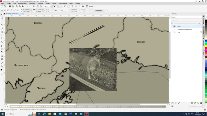
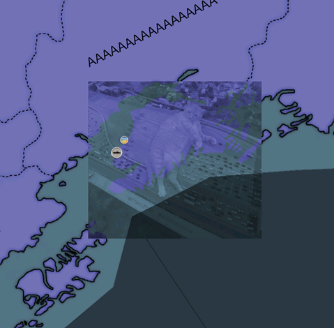
And yes, all the work is done in Colorscales - these files are responsible only for what the player sees - you can paint everything over with a black square or add a cat, the game doesn’t care. ProvID is responsible for the provinces that the game engine sees, as far as I understand.
1707975943680.png
1707975958497.png

Russia's color is her default color in Darkest Hour. True, now I have removed DH and therefore I cannot see the RGB code. I will add useful links to the topic that helped me understand the Jamies Map Utility. As a Russian speaker, I really regret that I don’t know English, but I understood what was talking about, if you are a native speaker, it will be easier for you.
 
Last edited:
  • 1
  • 1Like
Reactions:
No, there is only one map tool - Jamies Map Utility. Version 1.2.5b is more stable. I highly recommend it (sorry for my English).
When working with this utility, you work with only one layer - Lightmap1. Next, when you create map (use MapMaker), you get Lightmap1, Lightmap2, Lightmap3 and 4. They are all the same.
View attachment 1083635
To create another layer (lightmap2) - I simply copied the source files and changed them - for example, I added topographic maps or you can add labels to the oceans, as in HOI2, removed the names of the provinces. I created four folders for lightmaps each layer - modified them and compiled them through MapUtility. Then I just collected the lightmaps in a separate folder
View attachment 1083636
And yes, all the work is done in Colorscales - these files are responsible only for what the player sees - you can paint everything over with a black square or add a cat, the game doesn’t care. ProvID is responsible for the provinces that the game engine sees, as far as I understand.
View attachment 1083637View attachment 1083638
Russia's color is her default color in Darkest Hour. True, now I have removed DH and therefore I cannot see the RGB code. I will add useful links to the topic that helped me understand the Jamies Map Utility. As a Russian speaker, I really regret that I don’t know English, but I understood what was talking about, if you are a native speaker, it will be easier for you.
Thanks your helpful answer, I'm slowly getting into graphical stuff and map editing (my heart balanced to study geography and map making in university but I took another path), made me laugh with the cat ^^
 
123.jpg

It's interesting to change the projection and see it all in the game. Maybe I'll get there someday. The main difficulty is maintaining the original ProvID
 
  • 1Like
Reactions:
But what is the final goal of your work? Just I couldn't figure it out.
Do you want to create a DH mod with improved map visualization that other mods could use this improved map?
Or something another goal?

I would really happy if there would be found a genius map-master who can:

- divide Shanghai province into two Chinese and Japanese zones

- relocate the Japanese islands Iwo-Jima and Chichi-Jima to their correct place.

- reduce (or separate) the Kharkov province to the size of a city (like Stalingrad/Moscow/Berlin provinces)

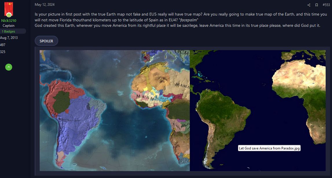
- ideally, it would be good to move both Americas about 8 defgree/900 kilometers down, because all paradox maps move Florida to the latitude of Spain, because by unknoun reasons, their religion forbids them to have a free maritime space under Africa.

Let God save America from Paradox2.jpg
 
Last edited:
But what is the final goal of your work? Just I couldn't figure it out.
Do you want to create a DH mod with improved map visualization that other mods could use this improved map?
Or something another goal?

I would really happy if there would be found a genius map-master who can:

- divide Shanghai province into two Chinese and Japanese zones

- relocate the Japanese islands Iwo-Jima and Chichi-Jima to their correct place.

- reduce (or separate) the Kharkov province to the size of a city (like Stalingrad/Moscow/Berlin provinces)

- ideally, it would be good to move both Americas about 8 defgree/900 kilometers down, because all paradox maps move Florida to the latitude of Spain, because by unknoun reasons, their religion forbids them to have a free maritime space under Africa.
The goal of this map is simply so that anyone can use it for their own purposes. You can use it as you please. Is this the final work? After translating the E3 map, I now see some issues of the map: the borders in the third layer are the blot in Italy, it is very clearly visible. What you indicated is very simple to do and generally does not require special skills. But this will not be a vanilla map, file distances will be recalculated, changes will be made to the scenarios and revolt files. I don’t think it’s necessary to move America - it’s a difficult task, you need to expand and contract provinces, work with three types of files at once, and there are 72 of them, but technically it’s possible.
 
  • 1
Reactions:
I can't help but be impressed with the 1000s of hours work put in to Darkest hour. The vast majority is completely free-of-charge. I wonder where this level of dedication ranks among Paradox games.
 
I can't help but be impressed with the 1000s of hours work put in to Darkest hour. The vast majority is completely free-of-charge. I wonder where this level of dedication ranks among Paradox games.
I myself don’t remember how I started doing this. Jamie Map Utility got me very interested and posts on the forum when someone added an island or something else inspired me. I started looking for anything that would help me figure out how to unpack the card. Next, I made a test blot in Alaska and wrote nonsense in the Pacific Ocean and compiled the map back - and it worked. Having understood the principle of operation, I began to translate all the names into Russian, according to the Province_names file. By the way, the English name of one Chinese province does not match the Province file, somewhere in the southeast of China, I don’t remember. I also worked out the moment when the name is on two different pictures. At first I couldn’t figure out how to connect them and moved them pixel by pixel manuallyo_O. Eh Providence, you have shaken my nerves. And when I translated everything and compiled the map, I was very happy that everything worked out.
But the joy did not last long. Something was wrong. I suddenly realized that the original map has four unique layers, unlike the original HOI2 map, where there are two. I was confused. I saw that the topography of the land and the seabed were missing. After reading the map creation guide again, I understood everything. Where can I get them? It is impossible to forgive the developers; I think that it is for a commercial product that work materials cannot be distributed. I ended up making one myself from a satellite image, but I wasn’t sure it would work. I was afraid that shades of gray would distort the picture very much. In the end, everything worked out. With its disadvantages - we see light stripes on the borders of the images in the game and black stripes from the strong transformation of the satellite image. Well, then E3, adding provinces, etc. I always wonder what tool the game developers had, what they used, if there is a connection with the files scenarios, ai, event.
P.S. I believe that if America were further south, it would add useless seas in the Indian Ocean. It is specifically aligned with Eurasia and Africa, I would do that too.
 
  • 1Like
Reactions:
P.S. I believe that if America were further south, it would add useless seas in the Indian Ocean. It is specifically aligned with Eurasia and Africa, I would do that too.
Сaptains of German raiders don't think so. :)
Exactly in the "useless" farthest southern parts of the ocean, far from trade routes, they met with tankers to replenish fuel and other supplies.

So rude moving America 1,000 kilometers up creates problems when setting correct distances between maritime provinces.

By the way, the creators of EU5 finally realized that this is wrong and America now is in its true place in the future EU5 map they published.
 
Last edited:
Added a link to the source files in topic. Archived with the strongest compression. After opening, the file weight will increase to 15 Gb. The programs used are listed in the first post
 
I still support this world map. Some revision was made. And so there was one error with missing name in province and since release it has not been fixed. The second point was that the borders in lightmap 2 and 3 were not clear. And reassembled these layers and now it seems to be more clear.
1.jpg
2.jpg

Also in the second layer I cleaned up all the reservoirs and lakes that were on the surface - this was especially clearly visible in Canada and Brazil. Now in lightmap 2 there are only oceans and those lakes that are in the game.
I also added a detailed guide in Russian on MapUtility, the link is attached above, in the first message. I tried to analyze in detail all the unclear things.
 
  • 1Like
Reactions: