Hello all,
In last week's dev diary many map changes were announced, including to the Low Countries, overjoying me and many others. This greatly improved the historical accuracy of the region, but I believe this can be further improved without creating provinces that are too small.

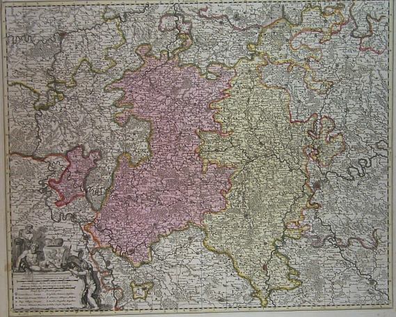
Take a moment to enjoy this colourful, home-edited map. While this map predates the EU4 start by ~44 years, the only differences are the existence of some small counties/lordships that were later absorbed into bigger ones, making the map reasonably suitable as a reference for this thread.
The changes announced last week amount to the following:
Adding Groningen improved the historical accuracy of Frisia, which is equally nice. However, a flaw consists of Groningen being controlled by the Friesland tag. This is historically inaccurate, for the following reasons:
The replacement of Limburg too is a good change in my opinion, as Upper Guelders has a bigger area than Limburg and does justice to Gelre, which was a major regional power during the first quarter of the game's time period and has an interesting history, including for example the Guelders Wars, in which it managed to hold its own against Charles of Habsburg for a remarkably long time.
However, while I prefer the current over the previous situation, I think it is still suboptimal. Limburg not existing has a negative effect on the historical accuracy of the region, as it was an important duchy, containing the important fortress city of Maastricht, in which many battles were fought. Additionally, the lack of Limburg means that Liège is not encircled by the historical Seventeen Provinces, which has implications for gameplay.
A graphical reason for adding Limburg is that the province of Liège currently has a bit of an awkward and angular shape. By carving a Limburg province out of the eastern part of Liège, this province is reduced to a size more similar to other provinces in the area. The newly created Limburg province would be big enough for the game. It would be owned by Brabant.

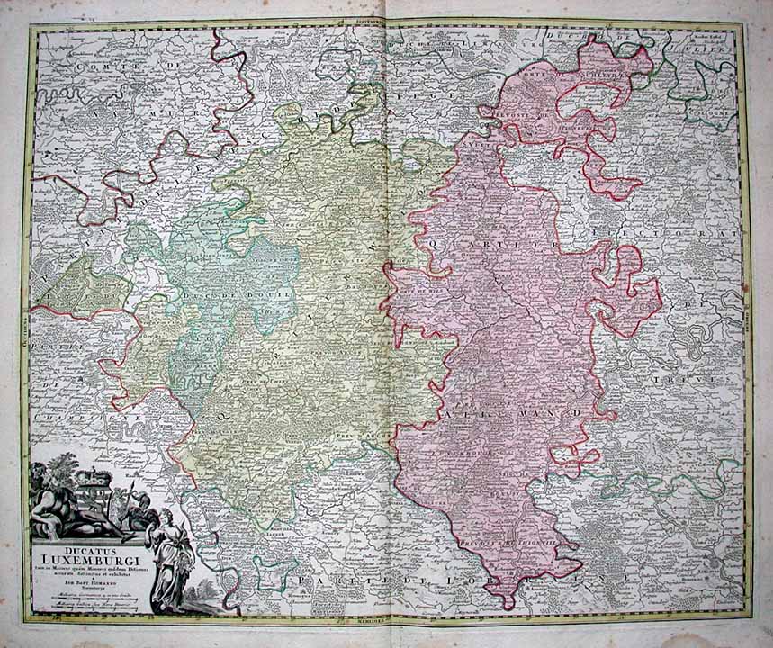
The top picture shows how the game map would look with the addition of a historically accurate Limburg province. The bottom pictures are maps of the same region in the mid-15th century, for comparing purposes. It can be seen that my proposed Limburg is bigger than Utrecht and about equal in size to Loon and Calais, three other provinces displayed in the picture.
The last opportunity I see for improving the current depiction of this region of the map concerns the non-existence of the duchy of Jülich. As has been explained before in different threads, Jülich was a significant regional power, at its height enjoying personal unions with Cleves, Berg and Gelre.
I think Jülich should be added as an independent province, in one of the following ways:

The top picture shows again the game map, this time with both the addition of Limburg and the split of Aachen into Aachen and Jülich. The alternative, replacing Aachen with Jülich would not affect any borders, hence why I didn't make a map for that.
I think that if these changes are implemented, the map of the Low Countries will be nearly completely accurate and more or less perfect for game purposes, as the only missing provinces (e.g. Tournaisis) would be undoubtedly too small to implement. It would greatly improve my experience and probably that of others who value historical accuracy of the map.
Thanks for reading.
TL;DR: To even further improve the historical accuracy of the Low Countries region within the limits of the game map I propose the creation of a Groningen tag and the addition of a Limburg province, which will not be too small. Additionally, a Jülich province could be added, which is however a wee bit more arguable in terms of size.
EDIT: For an improved version of my suggestion, see the first threadmark.
In last week's dev diary many map changes were announced, including to the Low Countries, overjoying me and many others. This greatly improved the historical accuracy of the region, but I believe this can be further improved without creating provinces that are too small.
Take a moment to enjoy this colourful, home-edited map. While this map predates the EU4 start by ~44 years, the only differences are the existence of some small counties/lordships that were later absorbed into bigger ones, making the map reasonably suitable as a reference for this thread.
The changes announced last week amount to the following:
- Holland has been divided into a northern and a southern province.
- The province of Oversticht was added, representing the holdings of Utrecht on the other side of Gelre.
- Friesland has been split in two, giving rise to the province of Groningen
- The province of Limburg has been removed in favour of a province called Upper Guelders (the southern exclave of Geldern on the map), with slightly different borders.
Adding Groningen improved the historical accuracy of Frisia, which is equally nice. However, a flaw consists of Groningen being controlled by the Friesland tag. This is historically inaccurate, for the following reasons:
- Groningen operated as an independent city-state. This is elaborated upon in this thread.
- According to Wikipedia, Friesland in this era was "ruled" by a mayor, chosen from one of thirty municipalities. None of these municipalities were located in the province of Groningen, implying they were not the same nation.
- The Groningen province also includes Drenthe, which was never under Frisian rule.
The replacement of Limburg too is a good change in my opinion, as Upper Guelders has a bigger area than Limburg and does justice to Gelre, which was a major regional power during the first quarter of the game's time period and has an interesting history, including for example the Guelders Wars, in which it managed to hold its own against Charles of Habsburg for a remarkably long time.
However, while I prefer the current over the previous situation, I think it is still suboptimal. Limburg not existing has a negative effect on the historical accuracy of the region, as it was an important duchy, containing the important fortress city of Maastricht, in which many battles were fought. Additionally, the lack of Limburg means that Liège is not encircled by the historical Seventeen Provinces, which has implications for gameplay.
A graphical reason for adding Limburg is that the province of Liège currently has a bit of an awkward and angular shape. By carving a Limburg province out of the eastern part of Liège, this province is reduced to a size more similar to other provinces in the area. The newly created Limburg province would be big enough for the game. It would be owned by Brabant.
The top picture shows how the game map would look with the addition of a historically accurate Limburg province. The bottom pictures are maps of the same region in the mid-15th century, for comparing purposes. It can be seen that my proposed Limburg is bigger than Utrecht and about equal in size to Loon and Calais, three other provinces displayed in the picture.
The last opportunity I see for improving the current depiction of this region of the map concerns the non-existence of the duchy of Jülich. As has been explained before in different threads, Jülich was a significant regional power, at its height enjoying personal unions with Cleves, Berg and Gelre.
I think Jülich should be added as an independent province, in one of the following ways:
- Replacing Aachen by Jülich. An advantage of this solution is that it wouldn't affect province clickability. As shown in the map on the bottom-left below, the free imperial city of Aachen only owned a fraction of the province, the vast majority consisting of Jülich. Aachen was politically far less relevant than Jülich. There are multiple examples were Paradox already decided not to place a free city on the map in favour of a bigger and more significant neighbour, such as Cologne, which is owned by the archbishopric rather than the city. A downside is the fact that the removal of a free city could be bad for the HRE. However, the addition of Groningen brings with it an extra potential free city.
- Breaking Aachen in two. As shown below, splitting a Jülich province off Aachen is viable, although bringing the size of Aachen down close to that of Utrecht and Frankfurt is suboptimal. Optionally, the provinces could be expanded slightly into Trier, to make them more sizeable.
The top picture shows again the game map, this time with both the addition of Limburg and the split of Aachen into Aachen and Jülich. The alternative, replacing Aachen with Jülich would not affect any borders, hence why I didn't make a map for that.
I think that if these changes are implemented, the map of the Low Countries will be nearly completely accurate and more or less perfect for game purposes, as the only missing provinces (e.g. Tournaisis) would be undoubtedly too small to implement. It would greatly improve my experience and probably that of others who value historical accuracy of the map.
Thanks for reading.
TL;DR: To even further improve the historical accuracy of the Low Countries region within the limits of the game map I propose the creation of a Groningen tag and the addition of a Limburg province, which will not be too small. Additionally, a Jülich province could be added, which is however a wee bit more arguable in terms of size.
EDIT: For an improved version of my suggestion, see the first threadmark.
Last edited:
- 1

Upvote
0