• We have updated our Community Code of Conduct. Please read through the new rules for the forum that are an integral part of Paradox Interactive’s User Agreement.
Status
Not open for further replies.

EU4 - Development Diary - 9th of October 2018

Welcome all to today’s dev diary, where I’ll be covering the long-awaited Iberian and North African map update coming in the 1.28 ‘Spain’ update.

iberia_map.png


Nations released for the sake of example


As things currently stand, though as always things are subject to change before release, Iberia consists of 571 development over 63 provinces. This includes the Macaronesia area but now excludes Labourd, which has been returned to the French region.

In Aragon, the distinction between the Kingdom of Aragon, the Kingdom of Valencia, and the Principality of Catalonia has become more pronounced. Tarragona is now rightly in the Catalonia area, and the province of Valencia has been split so that Castello and Xativa have become separate provinces. Valencia itself has the potential to be a very rich city indeed, as the player’s actions can lead to it becoming a major producer of silk. The three major Balearic Islands have become provinces in and of themselves, linked together by a strait and comprising their own Area.

Likewise, Galicia has seen itself grow from 1 province to 4, and now has an Area all to itself.

Portugal and Granada have been gifted one additional province each: Aveiro and Malaga respectively.

Last but not least, many citizens of Navarra are looking a little confused as they wonder where their coastline has gone. Wedged between major powers and with no immediate means of escape over the ocean, Navarra will be a very challenging nation in 1.28.

New releasable nations:

Valencia: The Kingdom of Valencia was a major constituent part of the Crown of Aragon in 1444. In 1.28 the former kingdom of El Cid will be a releasable nation.

Asturias: The Kingdom of Asturias ceased to exist long before our start date, but it nicely fills the absence of releasable nations in the region.

morocco_map.png


I’ve also taken another look at North Africa. Here we can see several new provinces along the coast, including those belonging to new nations that can emerge during the game.

The province of Demnate allows a route through the Atlas mountains; a convenient shortcut and potentially a deadly choke-point.

The Canary Islands have been split between Gran Canaria and Tenerife to represent the somewhat incomplete Castilian conquest and colonization of the islands.

For the masochists among you who play as Granada, they now have a core on the province on Ceuta.

New releasable nations:

Salé and Tétouan: Home to some of the most infamous Barbary Pirates, these nations will be releasable in 1444, and may emerge dynamically in the course of the game in the style of Habsan.

fezzan_map.png


Finally, I’ve made some minor changes to the eastern Maghreb. The province of Kairwan has been added for Tunis, and the addition of Sabha has allowed a more aesthetic redrawing of Fezzan’s borders.

That’s all for today. Next week, @Groogy will reveal some of the new features coming in the as yet unnamed Immersion pack to be released alongside 1.28.
 
Last edited:
  • 1
  • 1
Reactions:
Just to make it easier for devs, here goes a quick, dirty and simplified map of mountains and big valleys in Spain, which should make it easier to decide on provinces and terrain. Limits of provinces today might seem random, but mostly they aren't and there are some pretty good "physical" reasons for them being that they are. Again, keep in mind that this is extremely simplified.

View attachment 409924

So, the red lines: mountains. Pyrenees and the ones close to the northern coast, mostly over 2k metres and as such quite impassable. Same goes for the red line down south: it's not a coincidence that the frontier line for Granada was what it was: that´s where the mountains more or less started.

As for the brown line: Sierra Morena. Funny one: if you look at it from the south (Andalucia), it looks quite impressive. Highest summit being between 1.300 and 1.400, while Seville and Cordoba are 7 and 106 metres respectively. But if you look at it from the north, from Ciudad Real, it's barely a bunch of rolling hills: Ciudad Real is in the "meseta" and 628 metres high. It would´ve been a problem to attack from the south, but merely a nuisance to attack from the north (and it did not stop at all the reconquering efforts of the christians merely 200 years prior to the start of the game (it took less than 50 years for Castille to make it from Calatrava, in what today is Ciudad Real province, to Seville, for example).

As for the blue lines: main rivers (from north to south: Ebro, Duero, Tajo, Guadiana, Guadalquivir), which are the flat areas through which movement should be wuick and without any problem.

This map explains why so many people are complaining about the shape of Madrid: a flat province near Valladolid, which should be another flat province, would fail to take into account that Madrid was indeed protected by mountains if attached from the north or the east.

There are other smaller ranges of mountains not reflected (between Salamanca and Cáceres, also within Barcelona and Tarragona, between the Tajo and the Guadiana) but, again, this was supposed to be a simplified map and you would need probably double the number of current provinces to reflect it all.

I help you post it here:
https://forum.paradoxplaza.com/foru...ck-province-names-and-city-locations.1123146/

And, I´d really like to see the Segura river represented. A VERY VERY important for Jaen and Murcia at the time. Due to droughts and desertification it´s not a big river now but that hasn´t always been the case
 
Last edited:
From the late middle ages until the 19th century most European countries saw the language of the administration become the language of the educated people across its territory. This wasn't by active suppression and punishment of those that didn't speak it, but because dealing with the administration or with having any high education required the use of that language.

Education in Galicia since 1981 makes Galician compulsory for at least half of the subjects. And yes. The Spanish Constitution says every Spanish citizen must be able to speak Spanish, which is already the case for everyone who grows up in Spain. I don't see what's wrong with making sure everyone in Galicia is able to speak both Galician and Spanish. I can't see the nationalism in teaching the two majority languages of Galician society.
Quick reminder, the goal of the development diary is to share information with the fans and gather feedback from the community. Let's not delve into regional politics and semantics. As long as it is constructive, civil and aimed at the development diary, no problem. Keep this discussion out of the forums.

To summarize, please use Galician placenames using whatever criteria you have fixed for it. But don't mix Galician and Spanish placenames like you do in the map you've shown.
 
As a river it's quite irrelevant. It's relevance comes from the fact that it made big parts of Murcia and Alicante estremely fertile.

I wouldn´t say it´s quite irrelevant however it´s true it´s not as big as other rivers. Fair enough.
How about adding the Murcia kingdom as a cristian releasable nation? (Murcia+Albacete+Alicante).

I think dividing Extremadura in 3 provinces is ideal, as shown on the first post.

[...]

And if we are going to get exquisite with releasable nations we should also get the kingdom of Murcia (maybe Albacete + Murcia + Alicante). That would be an interesting kingdom to release to feed North Africa to.
Wikipedia (sorry no english)
https://es.wikipedia.org/wiki/Reino_de_Murcia_(Corona_de_Castilla)

There was the castle in Lorca (near Murcia) and the shipyard/port in Cartagena. Also, it had relevance in the commerce with Venice and Genova so it was a cultural hub during the rennaissance and afterwards during the barroco period

[...]

PS.: Yeah I´m from Murcia :D:D
 
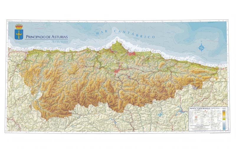
Wouldn't the mountain be an issue when trying to pass troops in Asturias? I'll talk to the team about that (and also about the coal element following industrial revolution, but that might be out of the scope of the game, right?)

I am Cantabrian and I think that Asturias and Cantabria are well represented as meadows, since the Cantabrian coast is the greenest region of Spain, and has meadows, and although it has mountains and hills, they forget the numerous green valleys of this region.

dd7622dd-7545-e37e-7c23-e8bf46c9733b


What I think happens is that there are people who confuse the Cantabrian mountain range with the Cantabrian coast. The north, like much of Spain is a very mountainous region, I think that Spain is the second most mountainous country in the European Union after Switzerland. If the north were mountain, half Spain should be too.

mapa-f%C3%ADsic-dEspanya-1024x636.jpg


I defend that the terrain type of the peninsula is well represented.
 
I wouldn´t say it´s quite irrelevant however it´s true it´s not as big as other rivers. Fair enough.

On a global scale? :p Absolutely irrelevant. We're talking only about the Iberian peninsula here, but the game represents the whole world.
 
I am Cantabrian and I think that Asturias and Cantabria are well represented as meadows, since the Cantabrian coast is the greenest region of Spain, and has meadows, and although it has mountains and hills, they forget the numerous green valleys of this region.

dd7622dd-7545-e37e-7c23-e8bf46c9733b


What I think happens is that there are people who confuse the Cantabrian mountain range with the Cantabrian coast. The north, like much of Spain is a very mountainous region, I think that Spain is the second most mountainous country in the European Union after Switzerland. If the north were mountain, half Spain should be too.

mapa-f%C3%ADsic-dEspanya-1024x636.jpg


I defend that the terrain type of the peninsula is well represented.

No. More than half of the north is absolutely and perfectly flat. A flat plateu more than 600m above sea, but flat nonetheless. Asturias and Cantabria are very green, true, but full of mountains. Maybe you think mountains cannot be productive, but that is not the case.
 
so...
Valencia, in fact, is where they have put Xativa, and Castello is where they have put Valencia. They should put in Xativa Valencia, in Valencia Castello and in Castello Peñiscola (for example)
and Lleida... I better not speak...
Please, look at a map of Spain...
 
I am Cantabrian and I think that Asturias and Cantabria are well represented as meadows, since the Cantabrian coast is the greenest region of Spain, and has meadows, and although it has mountains and hills, they forget the numerous green valleys of this region.

dd7622dd-7545-e37e-7c23-e8bf46c9733b


What I think happens is that there are people who confuse the Cantabrian mountain range with the Cantabrian coast. The north, like much of Spain is a very mountainous region, I think that Spain is the second most mountainous country in the European Union after Switzerland. If the north were mountain, half Spain should be too.

mapa-f%C3%ADsic-dEspanya-1024x636.jpg


I defend that the terrain type of the peninsula is well represented.

Mmm, I don't agree at all. I can assure you that Asturias has a big amount of mountains, and even the strip of land between the mountains and the sea is usually hilly. But a big chunk of the mountains range are inside the actual province, covering actually all the aproaches from the south with mountains up to 2000m in altitude (when measured to sea leavel) or around 1400-1500 meters when measured to the central plateau height. The simplified map that Tommassi has uploaded is a good simplification, because it's taking into account those mountain ranges and the height difference with surrounding areas, not absolute heights when measured from sea level.

And again, there are abundant historical examples that qualify those mountains as favorable terrain to any defender in Asturias (romans, moor invasion), so they were a real problem.

The fact that there is a good portion of Asturias or Cantabria that are flat or just hilly doesn't nullify the fact that there are very difficult mountains in the provinces constituting a natural defense / wall. It depends in the criteria of the developers, actually. I bet that all the provinces categorized as mountainous in the game have a smaller or bigger portion that is perfectly flat, but for the sake of simplicity, it's more correct to categorize them as mountainous, because for battle modifiers, and unit movement and economical development purposes, we should consider them mountainous.

The thing with Cantabria/Santander is that the Cantabrian mountains range doesn't cover all the south border of the cantabrian province, and there, it could be reasonably assumed that it might be hilly rather than mountainous, but I agree with him that Cantabria should be mountainous as Asturias for the sake of simplicity.
 
@RodDel

What about adding the Kingdom of Toledo as a releasable for Castille instead of Asturias? It was never independent and it always belonged to the crown of Castille but it could be a nice releasable tag that would actually be somewhat historical and since it didn't have much defined border you could actually have some liberty to add a few provinces.
738px-Corona_de_Castilla_1400_es.svg.png


https://en.wikipedia.org/wiki/Castilian_Kingdom_of_Toledo
A releasable kingdom of Toledo would make way more sense than the proposed kingdom of Asturias, for two big reasons:
- The kingdom of Leon IS the kingdom of Asturias.
- The lands given to the proposed kingdom of Asturias are the actual core of Castile, which started being a county in the area of Santander, at the very north of Castile.

The kingdom of Toledo was one of the "internal kingdoms" of the Castilian crown that resulted from conquering the small taifa Moorish kingdoms. So releasing Toledo or the southern kingdoms as separate states would make more sense than turning the core of Castile into an anachronistic misplaced kingdom.
 
I've taken a look at city positioning as well as a few other matters. First though I'd like to quote this post by @Trin Tragula which explains some of the reasoning behind such things:

To some extent things like province names are governed by design philosophy as much as anything.
...
The nudging of cities to be as close to the names capital of a province is also generally not adhered to. The wish has often been in the past to make sure they don’t obscure province names and other things more than anything (personally I do like when they are close to the province capital, but since this can change depending on start date or actions in game it’s not always possible).
Shapes can also at times be distorted for clarity of adjacency (connections need to be clear and more than one or two pixels) or size. London has had to eat some of it surroundings for instance, distorting the region a bit.

Now that said provinces should absolutely always contain the city they are named for, and it’s fine to argue that they should be named after another constituent city than they currently are.
Adding more trade centers is always a question of balance but moving around existing ones can always be considered (and so can adding new ones but the argument needs to be made specifically for why an additional one is needed).

The short version is that city positioning and province shapes aren't entirely a matter of historical geography. With that said, here's how Iberia is looking on my personal build right now. Once again, nations are released for the sake of example.

iberia_update.png
 
The thing with Cantabria/Santander is that the Cantabrian mountains range doesn't cover all the south border of the cantabrian province, and there, it could be reasonably assumed that it might be hilly rather than mountainous, but I agree with him that Cantabria should be mountainous as Asturias for the sake of simplicity.

The only reason for this is that those very same mountains continue in the northern part of the province of Burgos. Not that there is an easier path from the south. But Burgos is almost entirely flat, so no point in making it different. Should be more than well represented with the basque province being hilly and Cantabria being mountains.
 

This is illustrative. And the greener areas that according to the legend are "0 meters", are usually hilly / not flat.

I am going to give another hint: this https://es.wikipedia.org/wiki/Aeródromo_de_La_Morgal is one of the first airports in Asturias. It was built in the only naturally flat surface that they were able to find near the capital, Oviedo. In 1968, it was decided to move the airport to another place near Avilés, in the coast. Why? Because La Morgal "airport" was built in one of the only naturally flat surfaces in Asturias... but it was prone to have a lot of fog. They couldn't find a naturally flat surface not having some kind of other problems so they built the only airport in the region in a place where fog is there more than 50% of the year.
t0029607.jpg
 
I've taken a look at city positioning as well as a few other matters. First though I'd like to quote this post by @Trin Tragula which explains some of the reasoning behind such things:


The short version is that city positioning and province shapes aren't entirely a matter of historical geography. With that said, here's how Iberia is looking on my personal build right now. Once again, nations are released for the sake of example.

View attachment 409932
Extremely happy with the setup now, one final suggestion:
- name Urgell after its most important city; Lleida.
- I hope the capital of the Algarve is indeed Lagos.
- I hope the capital of Beira is correct.

Now on towards fact-checking the Maghreb. ;)
 
I've taken a look at city positioning as well as a few other matters. First though I'd like to quote this post by @Trin Tragula which explains some of the reasoning behind such things:


The short version is that city positioning and province shapes aren't entirely a matter of historical geography. With that said, here's how Iberia is looking on my personal build right now. Once again, nations are released for the sake of example.

View attachment 409932
If the idea is to have a releasable chunk of Castile, anything from Toledo south (Toledo included) had been independent states conquered by Castile in the previous couple of centuries. Releasing Castile's core territory as Asturias is kind of like releasing Wessex as England or Neustria as France.
 

Quick comments:

* Biscay was never part of Asturias.

* The shapes and positioning of Madrid and Avila still look weird to me. If you could find a way of including a province between Valladolid and Madrid that would be at least highlands (Segovia), white at the same time keeping the same number of provinces for Castille (perfect candidate for oblivion, Palencia), that would be ideal.

* You shouldn´t be able to move from Huesca directly into Tarragona. But you should be able to move from Zaragoza (flat) directly to Navarre and to Urgell (which I guess represents also Lérida).

* If you want to include a fourth province in the Valencia region, instead of breaking up Valencia in two, I would probably break up Alicante. The southernmost part of it (including Alicante) was part of Castille for a short while in the 13th century and both kingdoms fought for it for a long while in the century after that.
 
I've taken a look at city positioning as well as a few other matters. First though I'd like to quote this post by @Trin Tragula which explains some of the reasoning behind such things:


The short version is that city positioning and province shapes aren't entirely a matter of historical geography. With that said, here's how Iberia is looking on my personal build right now. Once again, nations are released for the sake of example.

View attachment 409932
Thanks, I can definitely see the improvement! Have you considered what others have mentioned about the new province of Aveiro? It's not a reasonable addition from an historical perspective and its shape looks weird (and would require changing the capital in Beira from Viseu, since now that looks to be part of the Aveiro province). Have you tested changing Porto+Aveiro to Braga+Porto, reshaping the borders of the provinces a bit but otherwise occupying the same area?
 
Status
Not open for further replies.