Hello everyone, and welcome once again to another Tinto Maps! Today we will be taking a look at India! Yup, a whole subcontinent… Exciting!
Let me say a foreword before I start sharing with you some beautiful maps. Some of you may wonder why we decided to make the entire Indian subcontinent in just one DD, instead of spreading it a bit. There are two reasons for that. The first is the political situation: the Sultanate of Delhi is at its zenith, under Muhammad bin Tughlaq. You will soon see that it rules over more than half of the region, approximately; so splitting that polity into several DDs would have felt weird.
The other is that we felt that a more cohesive approach made sense in this region, as it’s sooo diverse compared to others, that the way we approached it, both for its setup and content, was from the generic to the particular; therefore, we think that it will also help us more when we tackle the review of the region. Speaking of that, don’t worry much about the time available to prepare suggestions; you may already know that we have a backlog of several regions, and therefore weeks, before we hit the Indian review, so you will have plenty of time to research and prepare them. In any case, as it’s a massive task (we know it firsthand), we’ll let you know a bit in advance when we plan to start the in-depth review of it, so you have time to wrap it up.
As a final say, I just want to mention that an old acquaintance of the community, @Trin Tragula , now Design Lead in CK3, helped us to map a big chunk of it. Thanks, mate! And now, maps!
Countries:


As I just mentioned, the Sultanate of Delhi is at its zenith, under Muhammad bin Tughlaq, extending through the Indo-Gangetic Plain, including Bengal, and to the south, throughout the Deccan. There we have its toughest contender, Vijayanagar, a county that is a bulwark of Hinduism. Other important countries around it are Orissa and Sindh, but much smaller countries generally surround Delhi. You might wonder how it would be possible to stop Delhi from completely controlling the region, then. For this, two things are affecting its capability to achieve it. The first is the base game mechanics: ruling over so many different cultures and religions with low control will be hard. The second is a Situation that involves the Fall of the Sultanate; if Delhi wants to succeed, it will have to fight back against rebellions, which involves the potential independence of the Bengalese countries or newborn ones such as the Bahmanis, and the multiple Indian states around it, which are ready to take over it.
Dynasties:

Locations:


 Yes, we are making some adjustments to the coloring of the mapmodes!
Provinces:


Areas:

The bug is still there, yes… The area that is to the southwest is Malabar.
Terrain:


Here we have a new type of topography: Atolls. We added it some months ago, as we worked on finishing the map of the Pacific Ocean, and it will be the last one added to the game.
Development:

A new map mode is born! Here you have the development of India. The most developed place is Delhi, which is part of the fertile Gangetic Plain.
Harbors:

Cultures:


 Not an entirely new map, but a glorious one. We chose it to be the one to present how the different cultures could be present in the game for a reason.
Religions:


 India is the birthplace of numerous religions, and that needs to be reflected in the religious map. The main religion is Hinduism, but don’t be deceived by its homogeneous look, as it will be quite deep feature-wise. We also have Buddhism, which is at a low point, after some centuries of prosecutions. Mahayana is a majority in Sindh, although that's not completely exact, as an earlier form of Buddhism was practiced there; we’re also not 100% convinced about it being a majority, as some sources and accounts set the Islamization of the region to be completed under the Ghaznavids, in the 11th and 12th century, while others delay it until the 14th century - we followed the later approach, but we're very open to feedback in this specific matter. Another form of Buddhism is Theravada, which is the most practiced religion in Sailan. Some interesting minorities present in the region are Jains (yellow stripes), Nestorians (the pink stripe in Malabar, which portrays the ‘Saint Thomas Christians’), Jews (which have their own separate culture, ‘Kochini’), and several Animist confessions, of which we’ve already split Satsana Phi, the traditional religion of Tai people, and Sanamahism, the religion of Meitei people. Oh, although it’s not strictly part of the region, the light blue stripes to the north is Bön religion.
Raw Materials:


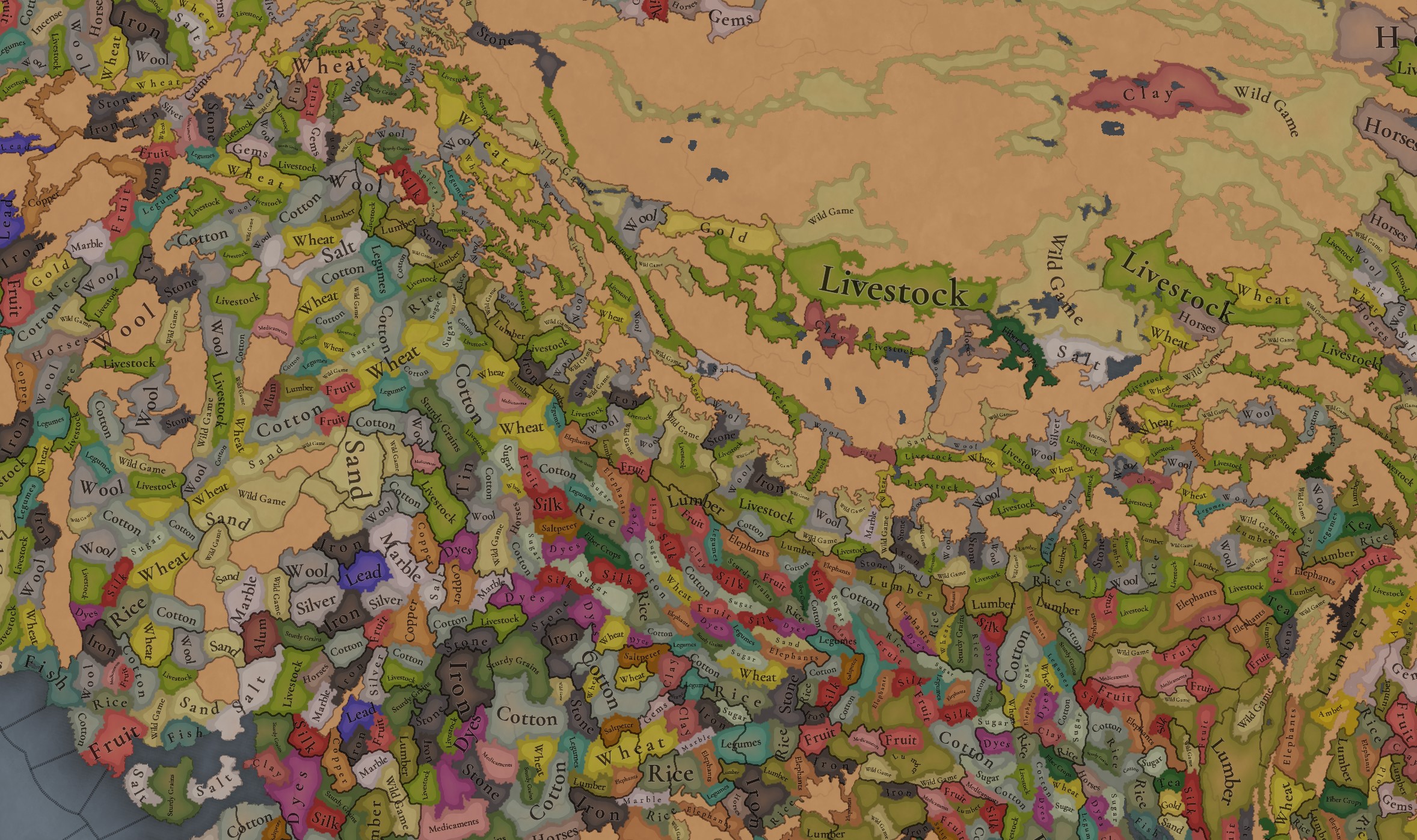
 India was for some time in the period the wealthiest region of the world, one of the main reasons being that it’s incredibly rich in very different types of resources, including some of the expensive ones. That will make for a very interesting economic gameplay.
Markets:

There are several market centers in India that we think portray well the situation in 1337: Kabul (yes, it’s in Afghanistan, but it’s one for the area of Kashmir), Delhi, Khambat, Calicut, Pulicat, Varanasi, and Chittagong.
Population:


India has a big population. To be precise, around 95M pops. Delhi is the second largest country in the world in population, with 41M pops, which makes it a behemoth, with very serious governance challenges. I’m also showing this week the progress we’re making with the coloring of the population mapmode; the stripes on several locations mark that they’re overpopulated, as they have more pops living on them than the pop capacity available (something that may be reviewed, as balancing very densely populated regions such as India or China is really challenging).
And that’s all for today! We hope you enjoyed this massive Tinto Maps. Next week we will be taking a look at the Steppe. Which one, you might wonder? Well, the one ruled by the Golden Horde, from Ukraine in the west to Mongolia in the east. Cheers!
Let me say a foreword before I start sharing with you some beautiful maps. Some of you may wonder why we decided to make the entire Indian subcontinent in just one DD, instead of spreading it a bit. There are two reasons for that. The first is the political situation: the Sultanate of Delhi is at its zenith, under Muhammad bin Tughlaq. You will soon see that it rules over more than half of the region, approximately; so splitting that polity into several DDs would have felt weird.
The other is that we felt that a more cohesive approach made sense in this region, as it’s sooo diverse compared to others, that the way we approached it, both for its setup and content, was from the generic to the particular; therefore, we think that it will also help us more when we tackle the review of the region. Speaking of that, don’t worry much about the time available to prepare suggestions; you may already know that we have a backlog of several regions, and therefore weeks, before we hit the Indian review, so you will have plenty of time to research and prepare them. In any case, as it’s a massive task (we know it firsthand), we’ll let you know a bit in advance when we plan to start the in-depth review of it, so you have time to wrap it up.
As a final say, I just want to mention that an old acquaintance of the community, @Trin Tragula , now Design Lead in CK3, helped us to map a big chunk of it. Thanks, mate! And now, maps!
Countries:


As I just mentioned, the Sultanate of Delhi is at its zenith, under Muhammad bin Tughlaq, extending through the Indo-Gangetic Plain, including Bengal, and to the south, throughout the Deccan. There we have its toughest contender, Vijayanagar, a county that is a bulwark of Hinduism. Other important countries around it are Orissa and Sindh, but much smaller countries generally surround Delhi. You might wonder how it would be possible to stop Delhi from completely controlling the region, then. For this, two things are affecting its capability to achieve it. The first is the base game mechanics: ruling over so many different cultures and religions with low control will be hard. The second is a Situation that involves the Fall of the Sultanate; if Delhi wants to succeed, it will have to fight back against rebellions, which involves the potential independence of the Bengalese countries or newborn ones such as the Bahmanis, and the multiple Indian states around it, which are ready to take over it.
Dynasties:

Locations:


Provinces:


Areas:

The bug is still there, yes… The area that is to the southwest is Malabar.
Terrain:


Here we have a new type of topography: Atolls. We added it some months ago, as we worked on finishing the map of the Pacific Ocean, and it will be the last one added to the game.
Development:

A new map mode is born! Here you have the development of India. The most developed place is Delhi, which is part of the fertile Gangetic Plain.
Harbors:

Cultures:


Religions:


Raw Materials:


Markets:

There are several market centers in India that we think portray well the situation in 1337: Kabul (yes, it’s in Afghanistan, but it’s one for the area of Kashmir), Delhi, Khambat, Calicut, Pulicat, Varanasi, and Chittagong.
Population:


India has a big population. To be precise, around 95M pops. Delhi is the second largest country in the world in population, with 41M pops, which makes it a behemoth, with very serious governance challenges. I’m also showing this week the progress we’re making with the coloring of the population mapmode; the stripes on several locations mark that they’re overpopulated, as they have more pops living on them than the pop capacity available (something that may be reviewed, as balancing very densely populated regions such as India or China is really challenging).
And that’s all for today! We hope you enjoyed this massive Tinto Maps. Next week we will be taking a look at the Steppe. Which one, you might wonder? Well, the one ruled by the Golden Horde, from Ukraine in the west to Mongolia in the east. Cheers!


