• We have updated our Community Code of Conduct. Please read through the new rules for the forum that are an integral part of Paradox Interactive’s User Agreement.

Tinto Maps #19 - 20th of September 2024 - India

Hello everyone, and welcome once again to another Tinto Maps! Today we will be taking a look at India! Yup, a whole subcontinent… Exciting!

Let me say a foreword before I start sharing with you some beautiful maps. Some of you may wonder why we decided to make the entire Indian subcontinent in just one DD, instead of spreading it a bit. There are two reasons for that. The first is the political situation: the Sultanate of Delhi is at its zenith, under Muhammad bin Tughlaq. You will soon see that it rules over more than half of the region, approximately; so splitting that polity into several DDs would have felt weird.

The other is that we felt that a more cohesive approach made sense in this region, as it’s sooo diverse compared to others, that the way we approached it, both for its setup and content, was from the generic to the particular; therefore, we think that it will also help us more when we tackle the review of the region. Speaking of that, don’t worry much about the time available to prepare suggestions; you may already know that we have a backlog of several regions, and therefore weeks, before we hit the Indian review, so you will have plenty of time to research and prepare them. In any case, as it’s a massive task (we know it firsthand), we’ll let you know a bit in advance when we plan to start the in-depth review of it, so you have time to wrap it up.

As a final say, I just want to mention that an old acquaintance of the community, @Trin Tragula , now Design Lead in CK3, helped us to map a big chunk of it. Thanks, mate! And now, maps!

Countries:
Countries.jpg

Colored Wastelands.png

As I just mentioned, the Sultanate of Delhi is at its zenith, under Muhammad bin Tughlaq, extending through the Indo-Gangetic Plain, including Bengal, and to the south, throughout the Deccan. There we have its toughest contender, Vijayanagar, a county that is a bulwark of Hinduism. Other important countries around it are Orissa and Sindh, but much smaller countries generally surround Delhi. You might wonder how it would be possible to stop Delhi from completely controlling the region, then. For this, two things are affecting its capability to achieve it. The first is the base game mechanics: ruling over so many different cultures and religions with low control will be hard. The second is a Situation that involves the Fall of the Sultanate; if Delhi wants to succeed, it will have to fight back against rebellions, which involves the potential independence of the Bengalese countries or newborn ones such as the Bahmanis, and the multiple Indian states around it, which are ready to take over it.

Dynasties:
Dynasties.jpg


Locations:
Locations.jpg

Locations 2.jpg

Locations 3.jpg

Locations 4.jpg
Yes, we are making some adjustments to the coloring of the mapmodes!

Provinces:
Provinces.jpg

Provinces 2.jpg

Provinces 3.jpg

Provinces 4.jpg

Areas:
Areas.jpg

The bug is still there, yes… The area that is to the southwest is Malabar.

Terrain:
Climate.jpg

Topography.jpg

Vegetation.jpg

Here we have a new type of topography: Atolls. We added it some months ago, as we worked on finishing the map of the Pacific Ocean, and it will be the last one added to the game.

Development:
Development.jpg

A new map mode is born! Here you have the development of India. The most developed place is Delhi, which is part of the fertile Gangetic Plain.

Harbors:
Harbors.jpg


Cultures:
Cultures.jpg

Cultures 2.jpg

Cultures 3.jpg
Not an entirely new map, but a glorious one. We chose it to be the one to present how the different cultures could be present in the game for a reason.

Religions:
Religions.jpg

Religions 2.jpg

Religions 3.jpg
India is the birthplace of numerous religions, and that needs to be reflected in the religious map. The main religion is Hinduism, but don’t be deceived by its homogeneous look, as it will be quite deep feature-wise. We also have Buddhism, which is at a low point, after some centuries of prosecutions. Mahayana is a majority in Sindh, although that's not completely exact, as an earlier form of Buddhism was practiced there; we’re also not 100% convinced about it being a majority, as some sources and accounts set the Islamization of the region to be completed under the Ghaznavids, in the 11th and 12th century, while others delay it until the 14th century - we followed the later approach, but we're very open to feedback in this specific matter. Another form of Buddhism is Theravada, which is the most practiced religion in Sailan. Some interesting minorities present in the region are Jains (yellow stripes), Nestorians (the pink stripe in Malabar, which portrays the ‘Saint Thomas Christians’), Jews (which have their own separate culture, ‘Kochini’), and several Animist confessions, of which we’ve already split Satsana Phi, the traditional religion of Tai people, and Sanamahism, the religion of Meitei people. Oh, although it’s not strictly part of the region, the light blue stripes to the north is Bön religion.

Raw Materials:
Raw Materials.jpg

Raw Materials 2.jpg

Raw Materials 3.jpg

Raw Materials 4.jpg
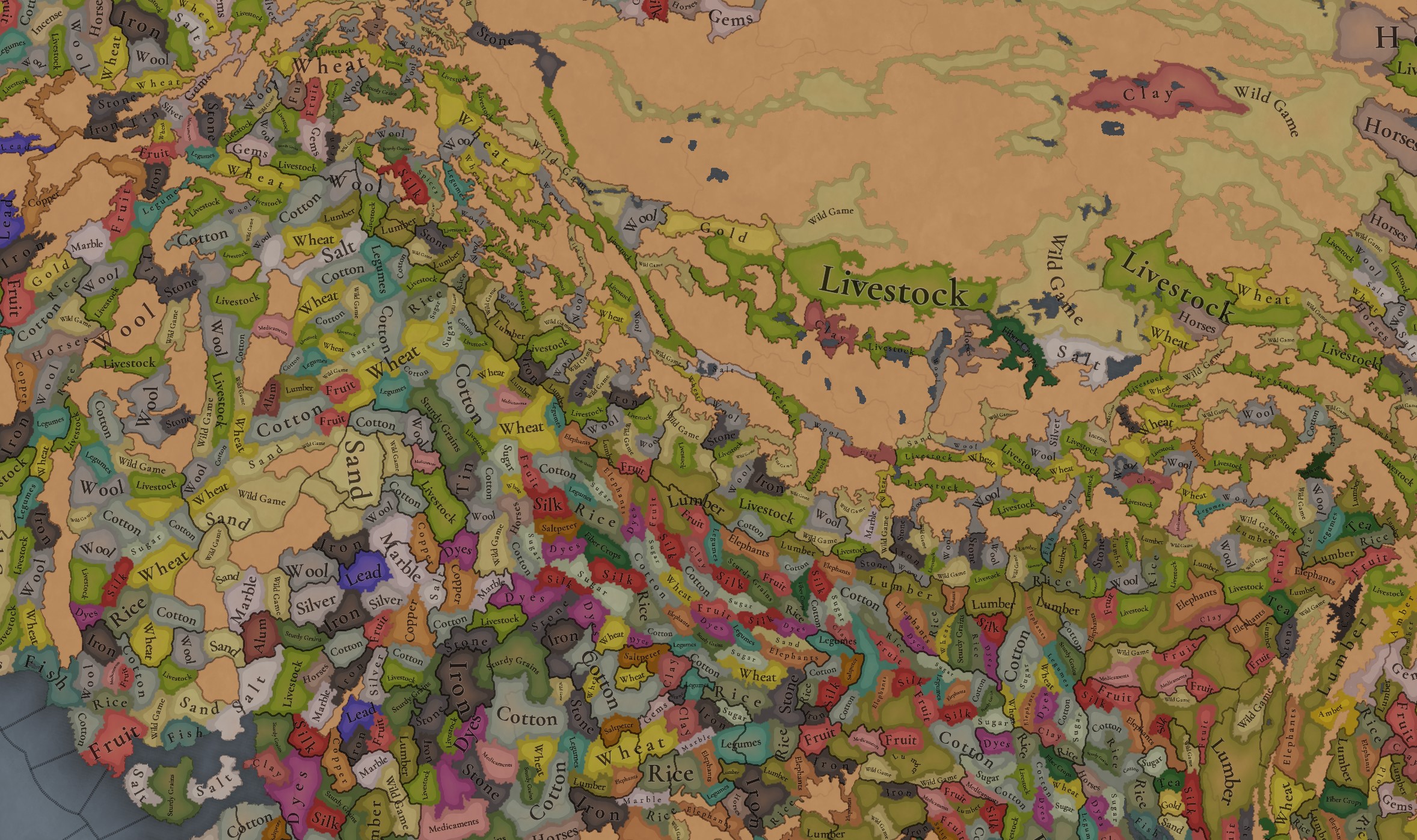
India was for some time in the period the wealthiest region of the world, one of the main reasons being that it’s incredibly rich in very different types of resources, including some of the expensive ones. That will make for a very interesting economic gameplay.

Markets:
Markets India.png

There are several market centers in India that we think portray well the situation in 1337: Kabul (yes, it’s in Afghanistan, but it’s one for the area of Kashmir), Delhi, Khambat, Calicut, Pulicat, Varanasi, and Chittagong.

Population:
Population.jpg

Population 2.jpg

Population 3.jpg

Population 4.jpg

Population 5.jpg

Population 10.jpg

Population 9.jpg

Population 6.jpg

Population 7.jpg

Population 8.jpg

India has a big population. To be precise, around 95M pops. Delhi is the second largest country in the world in population, with 41M pops, which makes it a behemoth, with very serious governance challenges. I’m also showing this week the progress we’re making with the coloring of the population mapmode; the stripes on several locations mark that they’re overpopulated, as they have more pops living on them than the pop capacity available (something that may be reviewed, as balancing very densely populated regions such as India or China is really challenging).

And that’s all for today! We hope you enjoyed this massive Tinto Maps. Next week we will be taking a look at the Steppe. Which one, you might wonder? Well, the one ruled by the Golden Horde, from Ukraine in the west to Mongolia in the east. Cheers!
 
  • 120Like
  • 98Love
  • 3
  • 3
  • 1
Reactions:
There needs to be some way to represent semi-autonomous governors of large empires, and the Delhi Sultanate and the later Mughal Empire are perfect examples of what I think needs to be represented. Both empires had governors that, after central authority weakened, declared independence, sometimes peacefully. For some examples, Jaunpur, Malwa, Bahmanis, and Gujarat for Delhi, and Bengal, Awadh, Hyderabad, and Carnatic for the Mughals.

I feel that a good way to do this is to have a building based country located in each of the capitals of these future states (if the governorship existed in 1337 of course, so no governor in Daulatabad), called a governor's mansion or something, and this building could project control around it, and any location that receives more control from this governor's mansion compared to the capital and is above a certain threshold would be considered a part of the governor's domain. This building should only be able to be built in a city location. All taxes from locations within their domain would go to the governor, and then the central government, depending on how loyal the governor is, or some other system, would get a cut of that. The governor should also be able to create their own armies, buildings and such. If a governor becomes disloyal, they stop paying taxes to their overlord, and if they see an opportunity, they will become declare independence and take their capital along with their domain, and their overlord could declare war in which case it would become like a rebellion, so all occupied locations will immediately flip to the overlord, and vice versa. If either side manages to capture the others' capital, the war immediately ends and the loser is full annexed. Proximity to overlord's capital should play a big role in determining how loyal a governor is.

If the governor becomes independent, the building should be destroyed, and when reconquered by their former overlord, they should have to rebuild the building, possibly in a different place as happened after the Lodis conquered Jaunpur, the new governor was located in Sasaram (the governor of which was Sher Shah Suri, who revolted during the Mughal conquest of Delhi, and founded the Sur empire). I say all this to show the historical precedent for a building/system like this existing.

The overlord should be able to choose the successor of the governor when they die. However, a disloyal governor should be able to choose their own successor. Only nobles/generals should be able to be appointed (or maybe even only generals, though pretty much all high ranking nobles in the Delhi Sultanate were also (not the best) generals). The governor building needs to be quite strong otherwise it would never be a good play to build it.

For the start of the game, I think that Delhi should have these buildings in Ahmedabad or Patan for Gujarat, Jaunpur for Jaunpur, Dhar for Malwa, and Sirhind or Lahore (I forget which was the seat of the governor of Punjab at the time).

I think this is a good compromise over having client states, which would look funky on the map, and not show a full empire. It is also better than predefined regions, because that detracts from the alt history. The Delhi governors, from what I can gather are going to have scripted independences, and that is fine, however, from the systems I've seen so far there does not appear to be any way model the system of governors that many of the Muslim empires in India after Delhi (and technically even the Hindu Marathas, though with their confederation after 1760s I think it would make sense to use client states instead because they were not appointed positions, but before that definitely).

I want to close this by saying that this is not something that is meant to be applicable to the whole world, and that a place like China that had complex bureaucracy and a high degree of centralization should not use this system. The reason it works for Indian empires is that many of them reached their height in a spree of quick conquests, and severely overextended their resources, requiring a large degree of delegation to govern their territories.

If there already exists a yet to be revealed system that models something similar, my praise to Paradox Tinto.
I think a system like this would work well and probably actually be necessary in China during periods of division when the state is weak, but not most of the time and not at game start. During the early Qing dynasty for example, seven provincial governors rebelled against the dynasty (3 in 1647, 1 in 1672, 2 in 1674, and 1 in 1676).

In the Chinese cases, the area around the Governor's office controlled by the governor would just be the Area it belongs to, and I think this system would work better for India as well, if I'm not wrong?
 
  • 1Like
Reactions:
I have a few critiques of the Areas map mode.
The size difference between the areas is massive, even ones that are right next to each other, and the shapes they take are really strange from a geographical perspective. I don't know what areas affect gameplay wise, but from other Tinto Maps they are somewhat supposed to be administrative/geographic/cultural regions (hopefully not administrative, because most Indian empires did not have similar administrative divisions (I had a proposal for this earlier in this thread), but that's besides the point). So going with geographic/cultural regions, I feel the map is still quite strange. Why does Chhota Nagpur even exist, it's only one province? Gondwana is so strangely shaped. Many such issues. (South India is good though)

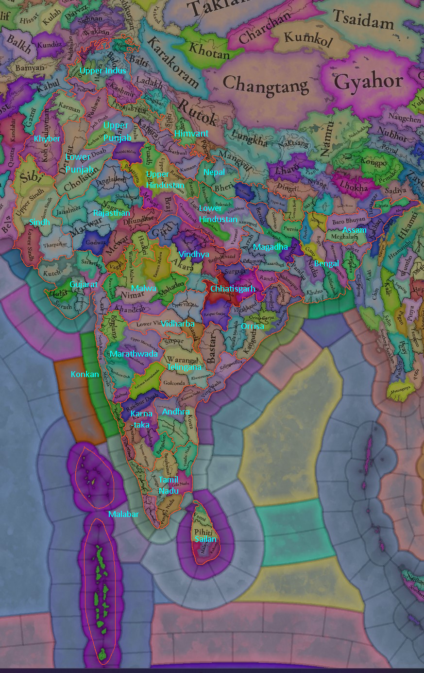
This is what I have come up with as a suggestion following the provinces (names are probably not what should end up in the final though:

Edit: Removed the old image, and replaced it with one that has a few more changes.
1740099736446.png
 

Attachments

  • 1736901124324.png
    1736901124324.png
    1,9 MB · Views: 0
Last edited:
  • 4Like
  • 3Love
  • 2
  • 1
Reactions:
Jaffna did not by any means have direct control over the forested Vanni region, with loyal chiefs instead doing all the day-to-day administration in the region. Sri Lanka should look less like it does now, and more like this instead:
1737162549371.png

I understand these exact borders may be difficult to portray, so Paradox should feel free to merge some of the smaller Vanni chiefdoms together and to make adjustments to the exact borders (which were often in flux anyways) if needed. I'll make a political map based on new suggestions for locations later if I end up having the time (alongside a more comprehensive review of Sri Lanka as a whole).

Here are the various states in Sri Lanka labeled (the dashed out region indicates areas the Sinhalese monarchy exerted no real control over, though the exact extent of Sinhalese royal control is uncertain, we know that they controlled much of the Eastern part of the island in name only. I believe much of this territory lacked the level of organization that the Vanni chiefs provided further to the North, so ideally low control in the East could be represented simply through a few modifiers)
1737162775330.png

1: Jaffna
2: Mannar (Vassal of Jaffna)
3: Rajavanni (Vassal of Jaffna)
4: Marikarpattu (Vassal of Jaffna)
5: Kumaravanni (Vassal of Jaffna)
6: Anevilundan (Vassal of Jaffna)
7: Muneswaram (Vassal of Jaffna)
8: Sinhalese Kingdom
9: Colombo (Pirate state under Wazir Jalasti, the so called 'Lord of the Sea') [Should ideally be represented as a navy based country]
10: Batticaloa (Tributary of Jaffna)
11: Trincomalee (Tributary of Jaffna)
12: Kattukolompattu (Vassal of Jaffna)
13: Tennamaravadi (Vassal of Jaffna)
14: Karrikattumalai (Vassal of Jaffna)
15: Mulliyavalai (Vassal of Jaffna)
16: Melpattu (Vassal of Jaffna)
17: Vavuniya (Vassal of Jaffna)
18: Panankamam (Vassal of Jaffna)
19: Karunavalpattu (Vassal of Jaffna)
 
Last edited:
  • 9Like
  • 2
Reactions:
I have a few critiques of the Areas map mode.
The size difference between the areas is massive, even ones that are right next to each other, and the shapes they take are really strange from a geographical perspective. I don't know what areas affect gameplay wise, but from other Tinto Maps they are somewhat supposed to be administrative/geographic/cultural regions (hopefully not administrative, because most Indian empires did not have similar administrative divisions (I had a proposal for this earlier in this thread), but that's besides the point). So going with geographic/cultural regions, I feel the map is still quite strange. Why does Chhota Nagpur even exist, it's only one province? Gondwana is so strangely shaped. Many such issues. (South India is good though)

Edit: Punjab should probably be split up into Lower Punjab and Upper Punjab. Lower should have Cholistan, Derajat, and Bari Doab. Punjab Hills could go to Upper Indus and Kangra could go to Nepal. The rest should go to upper. Also Bastar could go to Chhatisgarh.

This is what I have come up with as a suggestion following the provinces (names are probably not what should end up in the final though:
View attachment 1243592

Most of these changes seem quite good to me, although I would suggest Punjab Hills, Kangra, Garhwal, Kumaon and Doti to form a seperate area as in EU4, could be named as Himalayan Hills or Himvant.
 
  • 1
  • 1
Reactions:
The climates seem to not quite line up with the Koppen climate map for 1901-1930.
This is the map:
1737503558921.png

Specifically, there is too much tropical in northern India, most of Bengal should be subtropical. Parts of inland Orissa should also have subtropical. Also one or two locations on the border between Rajasthan and Gujarat should be subtropical as well.
This is a PNV (potential natural vegetation) map of India (source: Harvard):
Edit: Ignore all the random dots of green/other colors in the middle of large chunks of other colors. That was a mistake I made when generating the map.
1737503949822.png

According to this there should not be any jungles except west of the Western Ghats, small pockets in Orissa, Sri Lanka, East of Bengal, Nepal, and coastal Tamil Nadu. Although, I do not know what criteria is being used to determine jungles (is it type of vegetation, or density?). In my opinion, though all jungles outside the areas I mentioned should probably be turned into forests, or at least greatly reduced in number.
 
  • 2Like
  • 1
  • 1
Reactions:
Finally finished my Maharashtra rework. I used the Bombay, Hyderabad, and Central Provinces maps from the Imperial Gazetteer of India as sources (I put them in a previous post). Some of the locations might be in the wrong place due to projection issues though.
I tried to match the density of the regions of India with the most princely states in the places I could find the data for. I figured most of India should have a similar density, and the locations should be able to represent most of the princely states, so using the density of the parts of India with most dense princely states made sense.
1737525910005.png

For reference this is the princely state density in Gujarat:
1737526436720.png

This is obviously insane levels of detail, so I went with the size of the more normal sized states. (Don't want the entire HRE in just Gujarat)
 
  • 10Like
  • 3Love
  • 1
  • 1
Reactions:
Mewar was Independent under the rule of Rana Hammir Singh by 1337 after a successful campaign against the Tughlaqs in 1336, leading to a major defeat of the sultanate forces at the Battle of Singoli.
 
  • 2Like
Reactions:
Hey everybody; hey @vab9000 amazing work you've done!

I'd like to make a small suggestion regarding the Goa location (total area 3700 km2).
While liking the 3 location setup you've suggested, I'd change their layout a little bit, taking in account mainly the geography of the territory, as well as its historical evolution.

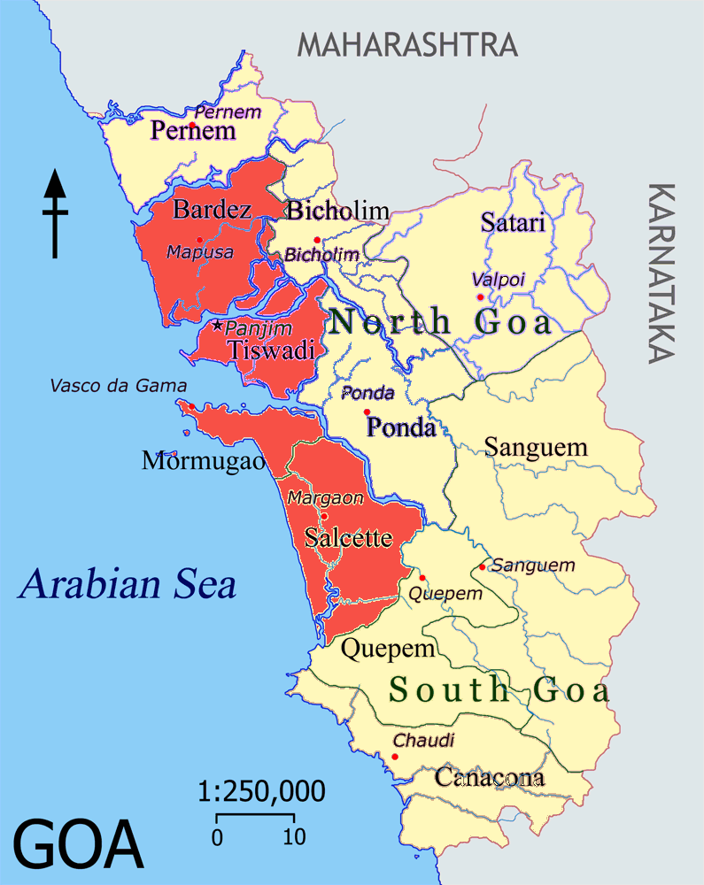
As you are probably aware of, Portugal took possession of the city of Goa (taluka of Tiswadi/Ilhas de Goa)in 1510-1512 and, by 1543, had secured control over most of the coastal plains that constitute around 2/3rds of the modern State of Goa coastline.

GoaConquistas.png


The Talukas in red made up the core of Portuguese territory, acquired over the course of ~30 years (1510-1543), and would become known as Velhas Conquistas (Old Conquests in Portuguese).
This territory's combined area is 865 km2 and its topography, disregarding Mormugão taluka and northern Bardez taluka with a more rugged orography, consists of plains heavily permeated by the Mandovi and Zuari rivers, their tribuataries (special note for the Cumbarjua Canal that separates Tiswadi from the mainland - therefore creating the Island of Goa), and their estuaries that surround Tiswadi/Ilha de Goa from the North (Mandovi) and South (Zuari).

anos.png

This image shows the year in which each taluka came under Portuguese sovereignty, and strongly correlates with the next one:

goarelevo.jpg

The topography of the territory.

Besides the plains of the Old Conquests, the rest of the territory is quite hilly, in relation with the Western Ghats.

Therefore I propose a division along these lines:
sketch1.jpg


Joining Pernem taluka and most of Bicholim and Pondá to the Old Conquests, I'd leave out Sattari and northern Sanguem to make up a hilly, jungle location, producing either iron or spices; and the remainder (Canacona, Quepem, and southern Sanguem) as another hilly jungle/woods loc, probably producing spices.
Goa loc, would remain as is (grasslands, plains).

In game it'd look something like this:
sketch2.jpg

1 - Goa
2 - Sattari
3 - Canancona

For natural harbor rating, Goa should be quite high (80%-100%), while Canacona should be almost irrelevant.

Cheers everyone!
 
  • 11Like
  • 3
Reactions:
Great overall representation of the region!!!
I just have some suggestions regarding the maps:
- support for persian/indic diacritics would help immersion in the game and modding: ṭ, ḍ, ṇ, ṣ, ṛ, ś, ḥ, ṃ, ḷ, ṅ, ā, ī, ū, ō, ē, ḻ, ḳ, ġ
-Assamese shouldn’t be in north bengal, it should be further east near where bodo is currently. The area currently occupied by in should be koch/kamati probably.
- couple of name corrections for the culture map: Balochi, Marathi, Bangali, Odiya, Sinhala
- the markets seem way too large: Lahore not being a market doesn’t make much sense for the amount of trading it controlled from delhi to kabul; consider breaking khambhat into 2 with a marathi port (like Chaul etc), north bengal and orissa should be with the rest of the bengal market and saptagram was a bigger centre of trade than chittagong; pulicat node would be better called nagapattinam as it was a more important port; calicut node should be called Muchiri/Muziris/Mahodayapuram as it was a bigger port; Deccan node centred around Bidar/Gulbarga would be useful
- some important medieval harbours seem to be missing: Saptagram, Nagapattinam, Khambhat, Chittagong,
- raw goods: central/west bengal (especially near the major ports) would have been big exporters of silk/cloth, dhaka would be an important exporter of silk/cloth, gujrati ports would also be exporting silk
 
  • 5Like
Reactions:
the markets seem way too large: Lahore not being a market doesn’t make much sense for the amount of trading it controlled from delhi to kabul; consider breaking khambhat into 2 with a marathi port (like Chaul etc), north bengal and orissa should be with the rest of the bengal market and saptagram was a bigger centre of trade than chittagong; pulicat node would be better called nagapattinam as it was a more important port; calicut node should be called Muchiri/Muziris/Mahodayapuram as it was a bigger port; Deccan node centred around Bidar/Gulbarga would be useful
Mostly agree. Didn’t think about it much earlier, but it definitely seems strange to have a market that crosses the Western Ghats, when there were cities that could be centers of trade to the east of them. However, Daulatabad would make more sense than Bidar, since it wasn’t developed much until the Bahmanis became independent, though Gulbarga could make sense.
 
  • 3Like
Reactions:
Another important discrepancy that I've noticed is the location of the Laur and Jaintia kingdoms. The Meghalaya area, consisting of the Garo, Khasi and Jaintia hills was entirely under the (nominal) rule of the Jaintia kingdom - but in this map it seems to be split between Laur to the West and Jaintia to the east.

This is however inaccurate. The Laur Kingdom was located in western Sylhet. To the north was the Jaintia Kingdom which cut off the Laur Kingdom from the Kamrup region. As the result the entire Meghalaya hills area should be under the Jaintia kingdom. It should have more impassable terrain in that area, and SOPs for Garos and Khasis.

The Laur Kingdom should be in the western part of Sylhet, which is occupied by the Taraf Kingdom on the map. The Taraf kingdom (Tungachal) should be restricted to the Eastern part, as they have only annexed the erstwhile Gour Kingdom around the start date, which was located in the eastern-southern plains of Sylhet.

Refer to the illustration below for a better idea. Excuse the horrible quality, graphic design is indeed my passion.

1739854157688.png
 
  • 6
  • 1Like
Reactions:
As for Sindh, not even gonna address the questionable religious depiction as many others have done already, but why is one country called "Sindh" - alluding to the region, and the other is called Samma, after the ruling dynasty? Either name them Upper Sindh and Lower Sindh or Samma and Soomra.

The Sammas usurped the Soomras and took the title of Jam, which is their version of 'Sultan' and ruled in the north of Sindh, which was established in 1336 and then eventually the whole of Sindh after 1351. The previous Soomra dynasty lost the title, but three rulers (using the title of Sardar) continued to rule Lower Sindh between 1336 and 1351 before eventually succumbing to the Sammas from the north. Calling one of them Sindh and the other just their dynastic name is very odd...

As for the dynastic map mode, why is the dynasty of lower Sindh "Muhammad Tur" and not Soomra or Soomro? Muhammad Tur was the name of a Soomra ruler who died... in 1256 lol. So yeah change that.

For more context, check out this book (specifically Chapter 3). https://sanipanhwar.com/uploads/books/2024-08-28_15-29-04_5a1c0e5564fd22d2cb1efcb5414447d5.pdf
And for the timeline of the Samma and Soomra dynasties ruling Sindh in a split fashion between 1336 - 1351 until Samma victory, check the trusty old wikipedia link which shows the overlap of the two dynasties perfectly: https://en.wikipedia.org/wiki/List_of_monarchs_of_Sindh

That being said, the dynasties of most of the subcontinent is a mess. I've brought up the dynastic inconsistencies of Bengal before, while citing sources but now that I have the free time to cross-reference other parts of the subcontinent, I'm finding more and more errors. As an extension of that, I think kingdoms like Oiniwar and Mallabhum as presented in Project Caesar also doesn't make sense over naming them Mithila/Tirhut and Bishnupur respectively. These were settled kingdoms, restricted to the region it occupied and doesn't really require dynastic naming like the vastly militaristic Islamic empires and sultanates. Matter of fact, when dynasties changed in these smaller hindu kingdoms, administration didn't change much either- for example the Oiniwar dynasty of Tirhut being succeeded by the Khandwala Dynasty of Darbhanga which were basically the same country different fonts - Mithila.
 
  • 6Like
  • 2
Reactions:
After creating the country map, I have created the locations map too for Garhwal.

View attachment 1193506

Some notable raw materials -

actual_location(location_in_game)

1. Copper - Dhanpur (Dugadda in our case), Bagodi (Tehri).
Only names are known and as their are many places with the same name, it is difficult to ascertain, which area had the resource, so I have made an educated guess. For example, we know that Uppu Garh was last to fall to Ajay Pal, so I have given the copper mine to the Bagodi which falls in Tehri.

2. Iron - Dasholi(Karnaprayag), Kujni(Kasmoli), Kuili(Badiyar), Bharpur(Devprayag)

3. Glass - Gitthi Patti(Purola)

4.Gold - Gold was filtered out of river along the bank of Alaknanda river by the people of Dhoni caste. There is also a gold mine in Suki village of Taknor (Barhat)


Dynasties ruling these independent kingdoms-
1. Chandpur Garh - Anat Pal II of Panwar Jati
2. Lohab Garh - ruled by Negi jati/caste
3. Dasholi Garh - This Garh was made famous by someone with the name Manavar
4. Nagpur Garh - Last king was Bhajan Singh.
5. Kuili Garh - Ruled by Sajwan jati
6. Kujni Garh - Ruled by Sultan Singh of Sajwan jati
7. Mungra Garh - Belonged to Rawat jati
8. Raika Garh - Ruled by Ramola jati
9. Molya Garh - Ramola jati. The famous Bhads (brave warriors and generals), Madho Singh Bhandari and Rikhola Lodi were of Ramola jati.
10. Uppu Garh - Ruled by Kaffu Singh Chauhan of Chauhan jati. It is a very interesting, albeit a little long for this post, tale how Kaffu was defeated by Ajay Pal.
11. Sankri Garh - Rana jati
12. Rami Garh - Rawat jati
13. Kandara Garh - Ruled by Narveer Singh of Kandari jati
14. Idia Garh - Idia jati
15. Garhtang Garh - Fort of Jadh people. They were responsible for security against Tibetans and the Bushahr kingdom.
16. Ajmir Garh - Payal jati
17. Sangela Garh - Bisht jati


I think I have covered most of the things related to Garhwal, if anybody has any suggestions please do tell. Also, what do you guys think, density of locations is not too much right? Because as compared to the european parts, it is still well under limit.

Also, I do have a book on Kumaoni history but it is too large for me to finish it in time. So if anybody else could review it, it would be awesome!


Provinces map for Garhwal region. Also, Maletha should be Khal in the locations map!


The green region consisting of Niti, Mana, etc should be Painkhanda/Penkhanda
 

Attachments

  • provinces.png
    provinces.png
    7,9 MB · Views: 0
  • 2Like
Reactions:
Hey everybody; hey @vab9000 amazing work you've done!

I'd like to make a small suggestion regarding the Goa location (total area 3700 km2).
While liking the 3 location setup you've suggested, I'd change their layout a little bit, taking in account mainly the geography of the territory, as well as its historical evolution.
Definitely agree with your change. I am not very familiar with Goa so I just went with the three biggest settlements in Goa during the time period without considering geography. I was hesitant to even put Goa in my map, but it is a part of the Konkan region so I figured it would go well together.
 
  • 1Like
Reactions:
Definitely agree with your change. I am not very familiar with Goa so I just went with the three biggest settlements in Goa during the time period without considering geography. I was hesitant to even put Goa in my map, but it is a part of the Konkan region so I figured it would go well together.
Thank you very much.

Really appreciate the work you've done and the effort you've put into all this.
Sadly, I lack enough in-depth knowledge of more regions of the Subcontinent (other than some scattered cities in the Western Coast), otherwise I'd have been more than happy to lend a hand (or just give an opinion or two).

Best regards.
 
Hello everyone, and welcome once again to another Tinto Maps! Today we will be taking a look at India! Yup, a whole subcontinent… Exciting!

Let me say a foreword before I start sharing with you some beautiful maps. Some of you may wonder why we decided to make the entire Indian subcontinent in just one DD, instead of spreading it a bit. There are two reasons for that. The first is the political situation: the Sultanate of Delhi is at its zenith, under Muhammad bin Tughlaq. You will soon see that it rules over more than half of the region, approximately; so splitting that polity into several DDs would have felt weird.

The other is that we felt that a more cohesive approach made sense in this region, as it’s sooo diverse compared to others, that the way we approached it, both for its setup and content, was from the generic to the particular; therefore, we think that it will also help us more when we tackle the review of the region. Speaking of that, don’t worry much about the time available to prepare suggestions; you may already know that we have a backlog of several regions, and therefore weeks, before we hit the Indian review, so you will have plenty of time to research and prepare them. In any case, as it’s a massive task (we know it firsthand), we’ll let you know a bit in advance when we plan to start the in-depth review of it, so you have time to wrap it up.

As a final say, I just want to mention that an old acquaintance of the community, @Trin Tragula , now Design Lead in CK3, helped us to map a big chunk of it. Thanks, mate! And now, maps!

Countries:
View attachment 1189937
View attachment 1190039
As I just mentioned, the Sultanate of Delhi is at its zenith, under Muhammad bin Tughlaq, extending through the Indo-Gangetic Plain, including Bengal, and to the south, throughout the Deccan. There we have its toughest contender, Vijayanagar, a county that is a bulwark of Hinduism. Other important countries around it are Orissa and Sindh, but much smaller countries generally surround Delhi. You might wonder how it would be possible to stop Delhi from completely controlling the region, then. For this, two things are affecting its capability to achieve it. The first is the base game mechanics: ruling over so many different cultures and religions with low control will be hard. The second is a Situation that involves the Fall of the Sultanate; if Delhi wants to succeed, it will have to fight back against rebellions, which involves the potential independence of the Bengalese countries or newborn ones such as the Bahmanis, and the multiple Indian states around it, which are ready to take over it.

Dynasties:
View attachment 1189938

Locations:
View attachment 1189939
Yes, we are making some adjustments to the coloring of the mapmodes!

Provinces:
View attachment 1189943

Areas:
View attachment 1189947
The bug is still there, yes… The area that is to the southwest is Malabar.

Terrain:
View attachment 1189948
View attachment 1189949
View attachment 1189950
Here we have a new type of topography: Atolls. We added it some months ago, as we worked on finishing the map of the Pacific Ocean, and it will be the last one added to the game.

Development:
View attachment 1189951
A new map mode is born! Here you have the development of India. The most developed place is Delhi, which is part of the fertile Gangetic Plain.

Harbors:
View attachment 1189952

Cultures:
View attachment 1189954
Not an entirely new map, but a glorious one. We chose it to be the one to present how the different cultures could be present in the game for a reason.

Religions:
View attachment 1189956
India is the birthplace of numerous religions, and that needs to be reflected in the religious map. The main religion is Hinduism, but don’t be deceived by its homogeneous look, as it will be quite deep feature-wise. We also have Buddhism, which is at a low point, after some centuries of prosecutions. Mahayana is a majority in Sindh, although that's not completely exact, as an earlier form of Buddhism was practiced there; we’re also not 100% convinced about it being a majority, as some sources and accounts set the Islamization of the region to be completed under the Ghaznavids, in the 11th and 12th century, while others delay it until the 14th century - we followed the later approach, but we're very open to feedback in this specific matter. Another form of Buddhism is Theravada, which is the most practiced religion in Sailan. Some interesting minorities present in the region are Jains (yellow stripes), Nestorians (the pink stripe in Malabar, which portrays the ‘Saint Thomas Christians’), Jews (which have their own separate culture, ‘Kochini’), and several Animist confessions, of which we’ve already split Satsana Phi, the traditional religion of Tai people, and Sanamahism, the religion of Meitei people. Oh, although it’s not strictly part of the region, the light blue stripes to the north is Bön religion.

Raw Materials:
View attachment 1189959
India was for some time in the period the wealthiest region of the world, one of the main reasons being that it’s incredibly rich in very different types of resources, including some of the expensive ones. That will make for a very interesting economic gameplay.

Markets:
View attachment 1190014
There are several market centers in India that we think portray well the situation in 1337: Kabul (yes, it’s in Afghanistan, but it’s one for the area of Kashmir), Delhi, Khambat, Calicut, Pulicat, Varanasi, and Chittagong.

Population:
View attachment 1189963

India has a big population. To be precise, around 95M pops. Delhi is the second largest country in the world in population, with 41M pops, which makes it a behemoth, with very serious governance challenges. I’m also showing this week the progress we’re making with the coloring of the population mapmode; the stripes on several locations mark that they’re overpopulated, as they have more pops living on them than the pop capacity available (something that may be reviewed, as balancing very densely populated regions such as India or China is really challenging).

And that’s all for today! We hope you enjoyed this massive Tinto Maps. Next week we will be taking a look at the Steppe. Which one, you might wonder? Well, the one ruled by the Golden Horde, from Ukraine in the west to Mongolia in the east. Cheers!
Pakistani Punjab population was still Hindu Buddhist during this period. It is late during British Start that they became Muslim. There are many sources like Hindus a dying race book and other British records. This means that Afghanistan and Baluchistan would also have significant Hindu Minorities. Kafiristan in Afghanistan also had people following some different religion till British era. Also one of the reasons India was Invaded so easily and the Invaders collapsed so easily is that 1. Hindus are not easy to convert. 2. Hordes use to invade India and had an advantage of horse when conquering but when they settled they lost the horse advantage.
 
  • 1
Reactions:
The original language of Peshawar is apparently Hindko (closely related to Punjabi). In 1881 "Punjabic" speakers were measured as 18.9% of the population of the Peshawar district. Pashtun tribes apparently settled in the area in the late 15th and 16th centuries, but I don't know if they were present before that. If anybody has more details/sources about this, that would be helpful.

So probably Peshawar should be Punjabi culture instead of Afghan?
 
  • 3
Reactions:
I'm wondering what people would think of merging the Ahom culture with their neighbouring Tai cultures, in this case Shan. The Ahom chronicles claim that they had only migrated into Assam (from Mong Mao, or nearby) ~100 years before 1337, and they still maintained close contacts with the Shan states until the 1500s (and further), which to me suggests that divergence was unlikely at this point.

Even in modern studies on the languages, northern Shan dialects are shown to be more similar to Ahom than they are to southern Shan dialects ("Phonological relationship between Ahom and Tai Nua" by Ranee Lertluemsai), and Shan is currently represented as a single culture.

There might be a bit of an issue with naming though, "Shan" might seem odd for people to see in Assam, and a simple "Tai" (which is the only name Ahom and Shan people used for themselves at this point) is already taken by the broader language group
 
  • 1Like
Reactions: