• We have updated our Community Code of Conduct. Please read through the new rules for the forum that are an integral part of Paradox Interactive’s User Agreement.

Tinto Maps #20 - 27th of September 2024 - The Steppes

Hello, and welcome one more week to the weekly encounter for map lovers! This week it’s also directed at horse lovers because we will be looking at the Eurasian Steppes, plus the Urals! So let’s start with the maps without further ado.

Countries:
Countries.jpg

Colored Wastelands.jpg

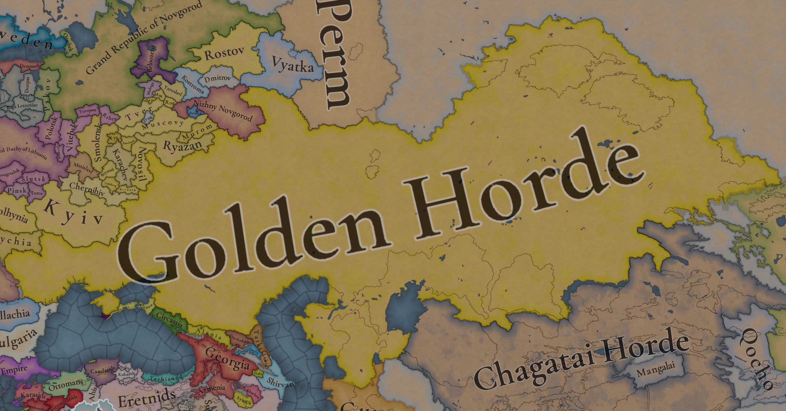
A glorious, Golden Horde! It is at its power peak, under the reign of Uzbeg Khan, so it's a much more menacing presence for its neighbors. However, it has its some internal issues that need to be managed, as you’ll notice in some of the maps, and in the future when we talk about the content for Hordes. The Golden Horde also heads its own IO, the Tatar Yoke, as shown in a previous Tinto Maps:

Tatar Yoke.jpg

We have already corrected the Ruthenian countries that are under the Horde’s Yoke, although we still have to correct the Russian principalities, which will be done in the corresponding Tinto Maps review. We’re also aware that we need to improve a bit the coloring of the IO, to mark not only the Golden Horde as the overlord of these countries, but also that Muscovy holds the title of the Grand Principality of Vladimir, which makes it the ‘enforcer’ of the Yoke. These fixes are also planned to be done in a few weeks.

Societies of Pops:
Societies of Pops.jpg

Societies of Pops 2.jpg .jpg

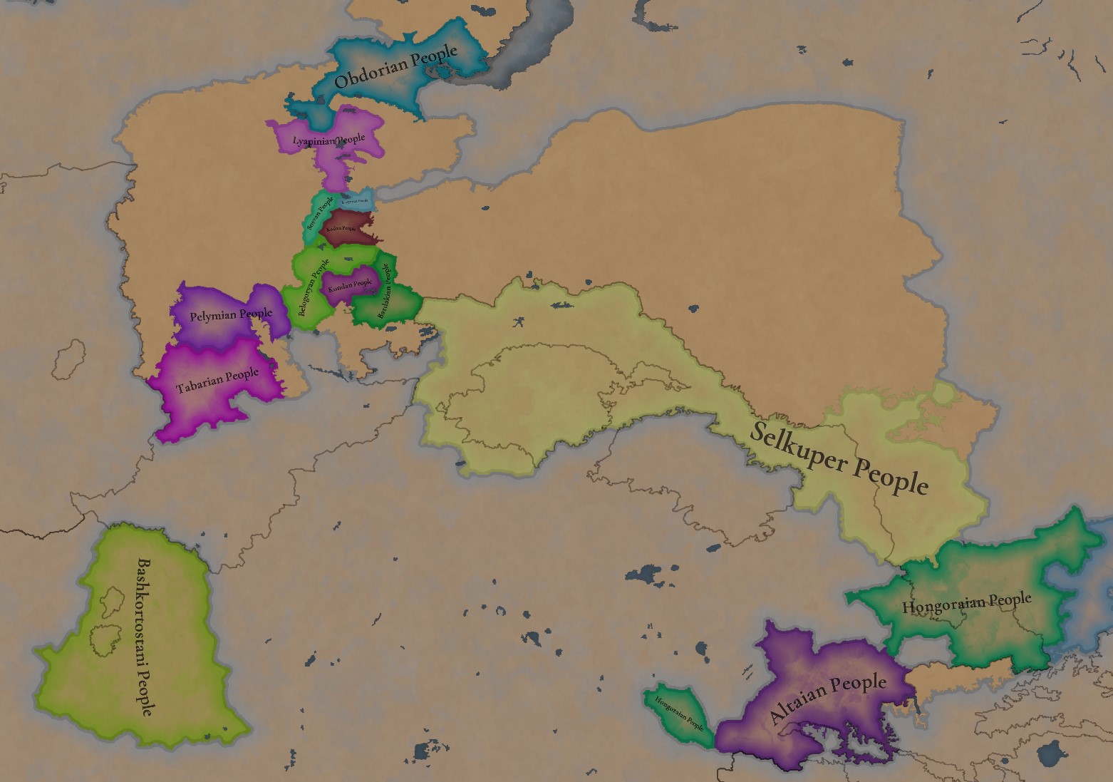
A bit up to the north, we have some Societies of Pops! This means that the territory of Western Siberia won’t be empty land, but will be populated by these people, which can be interacted with.

BTW, I’m not showing this week a dynasty map because, well, only the Borgijin dynasty rules over the lands of the Golden Horde, of course!


Locations:
Locations.jpg

Locations Western Siberia.jpg

Locations 3.jpg

Locations 4.jpg

Locations 5.jpg

Tons of locations today… You might notice that the density location is in a progression from west to east, from the most densely settled areas to the less settled ones. You may also notice that we’ve followed a design of ‘settler corridors’ in Western Siberia, setting those parts of the land that were habitable, usually on river valleys.

Provinces:
Provinces.jpg

Provinces 2.jpg


Areas:
Areas.jpg


Terrain:
Climate.jpg

Topography.jpg

Vegetation.jpg

The terrain is interesting here, as there are two main ecological areas. The first is the Steppes, Flatlands with Sparse and Grasslands vegetation, with either Cold Arid or Continental climates. And then we have the Siberian Arctics Forests, which are completely different, of course. On a note, the Urals were set as Hills, as they’re a quite settleable area, but we’ll probably make a review with your feedback, and add some mountains there.

Development:
Development.jpg

The whole region is not very developed, you might notice the difference with India, from last week’s Tinto Maps.

Harbors:
Harbors.jpg

There are some harbors in the Steppe region… In the Black Sea and Caspian Sea, of course! As usual, we’re open to feedback on this matter.

Cultures:
Cultures.jpg

Plenty of cultures! One note: Although we planned to work on the religious and cultural minorities of the region during the summer, we ended up not having enough time to add them. So what we’ll be doing today is showing the rough outline of ‘cultural spheres’, and then we’ll add the minorities during the review of the region. In that sense, feedback is very well received.

With that said the only note that needs to be made in terms of the cultural design is that we divided the Tatar cultural group into some differentiated regional cultures, being Crimean, Mishary, Kazani, and Astrakhani. We’re also aware that some of the cultures, as Mari and Chuvash, might be a bit displaced, as noted in the Russian Tinto Maps, so we’ll review and correct that with your feedback.


Religions:
Religions.jpg

Regarding Religions, the matter is a bit worse, as the big Sunni blob is just because the main religion of the Golden Horde is Islam, after the conversion of Uzbeg Khan, but that’s obviously incorrect. Also, as we have been able to forecast development time on how Pagan divisions will be during this autumn, we will make a comprehensive review of the region as well, to get a good distribution of ‘Shamanist’ Paganism, Tengrism, and Sunni Islam.

Raw Materials:
Raw Materials.jpg

Raw Materials 2.jpg

Raw Materials 3.jpg

Regarding the raw materials, the Steppes have plenty of Livestock and Horses, quite logically, although there are regions with some other goods. And up to the north, the main materials are Lumber and Fur. Apart from that, I want to mention the mineral hub in the Ural Mountains, with plenty of Copper, Iron, Gold, Lead, and Coal. That makes it a very mid and late-game interesting spot, and playing as Muscovy/Russia, I’ll tell you that you definitely want to expand into that region, as it will fulfill some of your material needs by that time.

Markets:
Markets.jpg

Markets! Big region, with lots of markets, although you may noticed that we changed the coloring of the locations that have 0% market access, which is the case in several areas. In any case, the market centers are Kaffa, Astrakhan, Saray-Jük, Kunya Urgench, Samarkand, Almaty, and Chimgi Tura. BTW, these names are much easier to notice in the game’s UI, as they’re beside the market centers:

Markets 2.jpg


Population:
Population.jpg

This week we’re showing only the country population mapmode, as there are some location numbers here and there which are failing, due to the already known issue with our pop editor (and which are on the way to be fixed). In any case, the whole population of the region is around 6.5-7M, of which around 6.3M are part of the Golden Horde. As I said, it’s a menacing country…

And that’s all for today! This is going to be my last Tinto Maps in a while, as I’ll be on vacation for 3 weeks during October (you might have noticed that I didn’t have any during summer), so one of the Content Designers in the team, @Roger Corominas , will step in and be in charge of the next 4 Tinto Maps. It’s in good hands, as Roger is an Experienced CD, who has been working and focused on Project Caesar for more than 3 years, at this point (this is why you might not know him from EU4, as other CDs in our team). In any case, he will be starting with the regions of Xinjiang, mostly ruled by the Chagatai Khanate, and Tibet.

I’ll keep reading and answering you during next week, and then I’ll be back in a month from now. See you!
 
  • 145Like
  • 48Love
  • 4
  • 3
  • 1Haha
Reactions:
Hello, and welcome one more week to the weekly encounter for map lovers! This week it’s also directed at horse lovers because we will be looking at the Eurasian Steppes, plus the Urals! So let’s start with the maps without further ado.

Countries:
View attachment 1193513
View attachment 1194073
A glorious, Golden Horde! It is at its power peak, under the reign of Uzbeg Khan, so it's a much more menacing presence for its neighbors. However, it has its some internal issues that need to be managed, as you’ll notice in some of the maps, and in the future when we talk about the content for Hordes. The Golden Horde also heads its own IO, the Tatar Yoke, as shown in a previous Tinto Maps:

View attachment 1194074
We have already corrected the Ruthenian countries that are under the Horde’s Yoke, although we still have to correct the Russian principalities, which will be done in the corresponding Tinto Maps review. We’re also aware that we need to improve a bit the coloring of the IO, to mark not only the Golden Horde as the overlord of these countries, but also that Muscovy holds the title of the Grand Principality of Vladimir, which makes it the ‘enforcer’ of the Yoke. These fixes are also planned to be done in a few weeks.

Societies of Pops:
View attachment 1193514
View attachment 1194158
A bit up to the north, we have some Societies of Pops! This means that the territory of Western Siberia won’t be empty land, but will be populated by these people, which can be interacted with.

BTW, I’m not showing this week a dynasty map because, well, only the Borgijin dynasty rules over the lands of the Golden Horde, of course!


Locations:
View attachment 1194075
View attachment 1194076

Tons of locations today… You might notice that the density location is in a progression from west to east, from the most densely settled areas to the less settled ones. You may also notice that we’ve followed a design of ‘settler corridors’ in Western Siberia, setting those parts of the land that were habitable, usually on river valleys.

Provinces:
View attachment 1194081
View attachment 1194082

Areas:
View attachment 1194083

Terrain:
View attachment 1194084
View attachment 1194085
View attachment 1194086
The terrain is interesting here, as there are two main ecological areas. The first is the Steppes, Flatlands with Sparse and Grasslands vegetation, with either Cold Arid or Continental climates. And then we have the Siberian Arctics Forests, which are completely different, of course. On a note, the Urals were set as Hills, as they’re a quite settleable area, but we’ll probably make a review with your feedback, and add some mountains there.

Development:
View attachment 1194087
The whole region is not very developed, you might notice the difference with India, from last week’s Tinto Maps.

Harbors:
View attachment 1194088
There are some harbors in the Steppe region… In the Black Sea and Caspian Sea, of course! As usual, we’re open to feedback on this matter.

Cultures:
View attachment 1194089
Plenty of cultures! One note: Although we planned to work on the religious and cultural minorities of the region during the summer, we ended up not having enough time to add them. So what we’ll be doing today is showing the rough outline of ‘cultural spheres’, and then we’ll add the minorities during the review of the region. In that sense, feedback is very well received.

With that said the only note that needs to be made in terms of the cultural design is that we divided the Tatar cultural group into some differentiated regional cultures, being Crimean, Mishary, Kazani, and Astrakhani. We’re also aware that some of the cultures, as Mari and Chuvash, might be a bit displaced, as noted in the Russian Tinto Maps, so we’ll review and correct that with your feedback.


Religions:
View attachment 1194092
Regarding Religions, the matter is a bit worse, as the big Sunni blob is just because the main religion of the Golden Horde is Islam, after the conversion of Uzbeg Khan, but that’s obviously incorrect. Also, as we have been able to forecast development time on how Pagan divisions will be during this autumn, we will make a comprehensive review of the region as well, to get a good distribution of ‘Shamanist’ Paganism, Tengrism, and Sunni Islam.

Raw Materials:
View attachment 1194093
View attachment 1194094
View attachment 1194095
Regarding the raw materials, the Steppes have plenty of Livestock and Horses, quite logically, although there are regions with some other goods. And up to the north, the main materials are Lumber and Fur. Apart from that, I want to mention the mineral hub in the Ural Mountains, with plenty of Copper, Iron, Gold, Lead, and Coal. That makes it a very mid and late-game interesting spot, and playing as Muscovy/Russia, I’ll tell you that you definitely want to expand into that region, as it will fulfill some of your material needs by that time.

Markets:
View attachment 1194096
Markets! Big region, with lots of markets, although you may noticed that we changed the coloring of the locations that have 0% market access, which is the case in several areas. In any case, the market centers are Kaffa, Astrakhan, Saray-Jük, Kunya Urgench, Samarkand, Almaty, and Chimgi Tura. BTW, these names are much easier to notice in the game’s UI, as they’re beside the market centers:

View attachment 1194101

Population:
View attachment 1194103
This week we’re showing only the country population mapmode, as there are some location numbers here and there which are failing, due to the already known issue with our pop editor (and which are on the way to be fixed). In any case, the whole population of the region is around 6.5-7M, of which around 6.3M are part of the Golden Horde. As I said, it’s a menacing country…

And that’s all for today! This is going to be my last Tinto Maps in a while, as I’ll be on vacation for 3 weeks during October (you might have noticed that I didn’t have any during summer), so one of the Content Designers in the team, @Roger Corominas , will step in and be in charge of the next 4 Tinto Maps. It’s in good hands, as Roger is an Experienced CD, who has been working and focused on Project Caesar for more than 3 years, at this point (this is why you might not know him from EU4, as other CDs in our team). In any case, he will be starting with the regions of Xinjiang, mostly ruled by the Chagatai Khanate, and Tibet.

I’ll keep reading and answering you during next week, and then I’ll be back in a month from now. See you!
The additions I would like to suggest to the map

Chuvash: indicated by red dots
1728659418245.png


Lyskovo existed since XII century as a Bulgar(Chuvash) fortress named Sundovit. but in 1410, it was named Lyskovo, so it probably can have a Muscovite minority already.

Erzya:
1728659430193.png

Alatyr - was created in the place of Mordva (Erzya) people in the 13 century(debatable up to the 15th century). Named after Erzya hydronym Раторлей. Still has Erzya diaspora
Nizhnii Novgorod was built on Erzya village of Obran Osh
Kurmish uezd(contains Alikovo, Sechenovo(should be Tyoply Stan),) had both Erzya and Chuvash people (7%, 25%)
Shatki - in XVI century was Erzya settlements
Arzamas - legends that it was built on Erzya city, has remnants of Erzya hillfort
locations Ardatov and Ardatovo - named after a given name in Erzya.
Insar - Mordva hydronym, still has a lot of Mordva people living
Karsun - Karsunski uezd was 10% Erzya 85% Russian.


Bogdanovo MUST be renaimed Narovchat or Mokhshi! It was an important city in the Golden Horde. But it had and still has Moksha people there

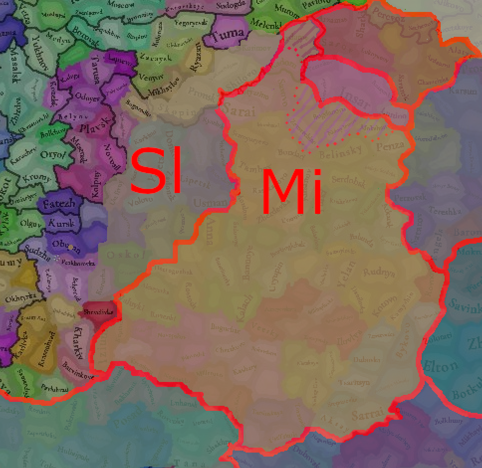
Mishary:
historically formed between rivers Tsna and Moksha (Shilovo, Tambov and Penza locations).

Kadom - was Mishary city! It was captured by conquests of Golden Horde
Ardatov - was a fortress used by the Golden Horde to collect yasak from Erzya people. That's why I think it should be majorly Mishary culture and have somewhat of a population.

Russians:
1728671032918.png

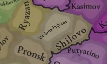
Vaskina Polyana MUST be renamed Isady. This city was founded in the 11th century, it should be present.
Pronsk - also was a Russian city. It was a center of Pronsk principality
Michurinsk should be named Kozlov
Usman - was a city built by settlers from Chernihiv in the 10th century
Kasimov - at that time was called Gorodets Meshersky (Meshera city) Was built before 1152 as a castle. In 1010, the region was converted to Christianity. Was never captured by the Golden Horde.


Final map:
Chuvash - white
Mishary - brown
Erzya - dark red
Moksha - pink

1728659467789.png
1728830714071.png
 
Last edited:
  • 5Like
Reactions:
The additions I would like to suggest to the map

Chuvash: indicated by red dots
View attachment 1200641

Erzya:
View attachment 1200642
Alatyr - was created in the place of Mordva (Erzya) people in the 13 century(debatable up to the 15th century). Named after Erzya hydronym Раторлей. Still has Erzya diaspora
Nizhnii Novgorod was built on Erzya village of Obran Osh
Kurmish uezd(contains Alikovo, Sechenovo(should be Tyoply Stan),) had both Erzya and Chuvash people (7%, 25%)
Shatki - in XVI century was Erzya settlements
Arzamas - legends that it was built on Erzya city, has remnants of Erzya hillfort
location Ardatov(should be named Sarov in Russian and Saryklych in Tatar, while location Ardatovo should be named Ardatov) - named after Erzya hydronym meaning marsh. Meshary Tatar Khans captured the city after the Golden Horde collapsed.

View attachment 1200643

Insar - Mordva hydronym, still has a lot of Mordva people living
Karsun - Karsunski uezd was 10% Erzya 85% Russian.


Bogdanovo MUST be renaimed Narovchat or Mokhshi! It was an important city in the Golden Horde. But it had and still has Moksha people there

Mishary:
historically formed between rivers Tsna and Moksha (Shilovo, Tambov and Penza locations). Moved south ONLY after the Russian conquest and colonisation. Other places that have Mishary culture currently should be changed.

View attachment 1200645View attachment 1200654
btw this is incorrect. Erzya people were moved there much later in time
1728660911034.png


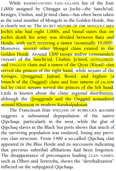
So while I initially thought that the Golden Horde had only a tiny minority of Mongols, it would appear they they had atleast 19,000 Mongol troops in the right wing (East), and 22,000 Mongol troops in the left wing (West).

This would translate to: (If we follow the equation that 1 troop = 5-6 family members)
95,000 / 114,000 Mongol pops in Eastern Golden Horde (The White Horde)
110,000 / 132,000 Mongol pops in Western Golden Horde (The Blue Horde)


"Encyclopedia of Mongolia and the Mongol Empire" (2004):

1728812953245.png


Last edited:
  • 2Like
  • 1
Reactions:
The additions I would like to suggest to the map

Chuvash: indicated by red dots
View attachment 1200641

Lyskovo existed since XII century as a Bulgar(Chuvash) fortress named Sundovit. but in 1410, it was named Lyskovo, so it probably can have a Muscovite minority already.

Erzya:
View attachment 1200642
Alatyr - was created in the place of Mordva (Erzya) people in the 13 century(debatable up to the 15th century). Named after Erzya hydronym Раторлей. Still has Erzya diaspora
Nizhnii Novgorod was built on Erzya village of Obran Osh
Kurmish uezd(contains Alikovo, Sechenovo(should be Tyoply Stan),) had both Erzya and Chuvash people (7%, 25%)
Shatki - in XVI century was Erzya settlements
Arzamas - legends that it was built on Erzya city, has remnants of Erzya hillfort
locations Ardatov and Ardatovo - named after a given name in Erzya.
Insar - Mordva hydronym, still has a lot of Mordva people living
Karsun - Karsunski uezd was 10% Erzya 85% Russian.


Bogdanovo MUST be renaimed Narovchat or Mokhshi! It was an important city in the Golden Horde. But it had and still has Moksha people there

Mishary:
historically formed between rivers Tsna and Moksha (Shilovo, Tambov and Penza locations).

Kadom - was Mishary city! It was captured by conquests of Golden Horde
Ardatov - was a fortress used by the Golden Horde to collect yasak from Erzya people. That's why I think it should be majorly Mishary culture and have somewhat of a population.

Russians:
1728671032918.png

Vaskina Polyana MUST be renamed Isady. This city was founded in the 11th century, it should be present.
Pronsk - also was a Russian city. It was a center of Pronsk principality
Michurinsk should be named Kozlov
Usman - was a city built by settlers from Chernihiv in the 10th century
Kasimov - at that time was called Gorodets Meshersky (Meshera city) Was built before 1152 as a castle. In 1010, the region was converted to Christianity. Was never captured by the Golden Horde.


Final map:
Chuvash - white
Mishary - brown
Erzya - dark red
Moksha - pink

View attachment 1200645View attachment 1201559
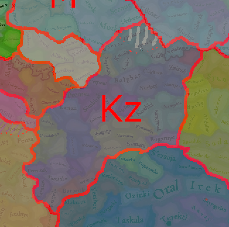
My proposal on correcting the lines between Tatar cultures. I based it majorly on the Khanates that broke from the Golden Horde as Tatars of that time associated more with the Khanate they were living in rather than something else. Only after the defeat of Khanates when they became settled, did their cultures start to drift apart
1728988505148.jpeg
1728988408496.jpeg


Kazan Tatars:
Primarily were settled around Kazan.
Yelabuga was built by the Bolgar people and was captured with the Bolgar by the Golden Horde. Should be part of the Golden Horde and have Kazan Tatar culture.
Vyatskiye Polyany - was controlled by Bolgars/Tatars until the 16th century. was populated by Udmurt and Tatar people
Döbyaz and Oli Baraza - built by Tatars in the 16th century.

AD_4nXchG3DdlqanDrn0QnAJ0zqw7ORRek6b73fnvaknVKv5Ig7bgTAoypAFOOScvp6HL3qBMPWwC-3TuaLSEjZD1K68qA08m3B7LCoPJfo1cEkXNHp-yrYJzl4r0pOwJ7IjuxNhRLSMoh9_n-ZeuBDpeM34BFNO
AD_4nXcv1WpnJYeAhfihgpKQ-u_Ex9AVuGJ4wxxXdapCRsjV3bkQyxG-KgvRmNtThx5WWkS-mTHuXi3m5kHPQTRAvUDFdq_MVG5hdfMvP-fW0QY0aHGJJVwCkWOZmAhMs278EEsO8frlGbBNHnALbkBcLV8fTdUt
1728988834985.png


South of the Volga River were populated by Nogay people.
The south-Eastern border is followed by the Bolshoy Kimel River as some middle ground between all proposals of borders of Kazan Khanate.
A lot of modern scientific research argues that Kazan Khanate did control the region until modern Samara.

My proposal:
1729670732256.png

Added Chuvash in Oli Baraza to represent people living in Arsk. The province should be remained to Arsk

Mishar Tatars:
The south border should follow around the borders of the Great Horde. Volga was populated along the river banks, but right after them was Nogay controlled steppes
As Saray al-Jadid remained part of the Great Horde I think it should be Mishar culture
My proposal:
1729670691532.png


Nogai Tatars:

Same idea with borders with other Tatars, Nogay people did not control up to the banks of the Volga River, but they were right beside it so I made a one location padding between the river and the Nogay people. But I agree with a border right near the Tobol and Yaik rivers as it will make this culture way too wide.
1729670761685.png


Bashkir:
It is important to remember that a lot of Tatar people migrated to their lands under the control of the Russian Empire as a way of colonisation by relocating armies. Thats why modern maps of Bashkir people are a bit skewed. For my map, I have mainly used a map of Bashkir Kantons in 1855, a map of Bashkir families with cities, and various maps of the indigenous people of Ural.
1728990169815.jpeg
1728993732134.png
1728993965976.png

Additional info: Bisert was built to defend against revolts of the Bashkir people. Yektul was under Bashkir family

My proposal:
1728993685060.png

Mari people on the top


Astrakhan Tatars:
I think Circassian people were underrepresented.
1728995054336.jpeg

The border with other Tatars follows the Volga, the Don, and minor rivers.
Rechnoye or Saray Batu (I believe it was somewhere there) was the old capital of the Great Horde

My proposal:
1729670623848.png


Crimea Tatars:
I think Budjak should have a Tatar culture but with a low population.
My proposal:
1728994933137.png


1729671808406.png
 
Last edited:
  • 6Like
  • 2
  • 1Love
  • 1
Reactions:
My proposal on correcting the lines between Tatar cultures. I based it majorly on the Khanates that broke from the Golden Horde as Tatars of that time associated more with the Khanate they were living in rather than something else. Only after the defeat of Khanates when they became settled, did their cultures start to drift apart
View attachment 1202359View attachment 1202358

Kazan Tatars:
Primarily were settled around Kazan.
Yelabuga was built by the Bolgar people and was captured with the Bolgar by the Golden Horde. Should be part of the Golden Horde and have Kazan Tatar culture.
Vyatskiye Polyany - was controlled by Bolgars/Tatars until the 16th century. was populated by Udmurt and Tatar people
Döbyaz and Oli Baraza - built by Tatars in the 16th century.

AD_4nXchG3DdlqanDrn0QnAJ0zqw7ORRek6b73fnvaknVKv5Ig7bgTAoypAFOOScvp6HL3qBMPWwC-3TuaLSEjZD1K68qA08m3B7LCoPJfo1cEkXNHp-yrYJzl4r0pOwJ7IjuxNhRLSMoh9_n-ZeuBDpeM34BFNO
AD_4nXcv1WpnJYeAhfihgpKQ-u_Ex9AVuGJ4wxxXdapCRsjV3bkQyxG-KgvRmNtThx5WWkS-mTHuXi3m5kHPQTRAvUDFdq_MVG5hdfMvP-fW0QY0aHGJJVwCkWOZmAhMs278EEsO8frlGbBNHnALbkBcLV8fTdUt
View attachment 1202361

South of the Volga River were populated by Nogay people.
The south-Eastern border is followed by the Bolshoy Kimel River as some middle ground between all proposals of borders of Kazan Khanate.
A lot of modern scientific research argues that Kazan Khanate did control the region until modern Samara.

My proposal:
View attachment 1202360
Added Chuvash in Oli Baraza to represent people living in Arsk. The province should be remained to Arsk

Mishar Tatars:
The south border should follow around the borders of the Great Horde. South of the Volga river were populated by Nogay people.
As Saray remained part of the Great Horde I think it should be Mishar culture
My proposal:
View attachment 1202362

Nogai Tatars:

Same idea with borders with other Tatars. But I agree with a border right near the Tobol and Yaik rivers as it will make this culture way to wide.
View attachment 1202363

Bashkir:
It is important to remember that a lot of Tatar people migrated to their lands under the control of the Russian Empire as a way of colonisation by relocating armies. Thats why modern maps of Bashkir people are a bit skewed. For my map, I have mainly used a map of Bashkir Kantons in 1855, a map of Bashkir families with cities, and various maps of the indigenous people of Ural.
View attachment 1202365View attachment 1202381View attachment 1202383
Additional info: Bisert was built to defend against revolts of the Bashkir people. Yektul was under Bashkir family

My proposal:
View attachment 1202380
Mari people on the top


Astrakhan Tatars:
I think Circassian people were underrepresented.
View attachment 1202390
The border with other Tatars follows Volga, Don, and minor rivers

My proposal:
View attachment 1202388

Crimea Tatars:
I think Budjak should have a Tatar culture but with a low population.
My proposal:
View attachment 1202389
About population density. I saw an awesome map of Kazan Khanate. It was untouched by Timur so it should resemble the current timeframe too.
1729012164083.jpeg

You can see here places which a colored fully even today contain a majority non-Russian population except Mokhshi and Sinbir.
 
  • 1Like
  • 1
Reactions:
Hello, and welcome one more week to the weekly encounter for map lovers! This week it’s also directed at horse lovers because we will be looking at the Eurasian Steppes, plus the Urals! So let’s start with the maps without further ado.

Countries:
View attachment 1193513
View attachment 1194073
A glorious, Golden Horde! It is at its power peak, under the reign of Uzbeg Khan, so it's a much more menacing presence for its neighbors. However, it has its some internal issues that need to be managed, as you’ll notice in some of the maps, and in the future when we talk about the content for Hordes. The Golden Horde also heads its own IO, the Tatar Yoke, as shown in a previous Tinto Maps:

View attachment 1194074
We have already corrected the Ruthenian countries that are under the Horde’s Yoke, although we still have to correct the Russian principalities, which will be done in the corresponding Tinto Maps review. We’re also aware that we need to improve a bit the coloring of the IO, to mark not only the Golden Horde as the overlord of these countries, but also that Muscovy holds the title of the Grand Principality of Vladimir, which makes it the ‘enforcer’ of the Yoke. These fixes are also planned to be done in a few weeks.

Societies of Pops:
View attachment 1193514
View attachment 1194158
A bit up to the north, we have some Societies of Pops! This means that the territory of Western Siberia won’t be empty land, but will be populated by these people, which can be interacted with.

BTW, I’m not showing this week a dynasty map because, well, only the Borgijin dynasty rules over the lands of the Golden Horde, of course!


Locations:
View attachment 1194075
View attachment 1194076

Tons of locations today… You might notice that the density location is in a progression from west to east, from the most densely settled areas to the less settled ones. You may also notice that we’ve followed a design of ‘settler corridors’ in Western Siberia, setting those parts of the land that were habitable, usually on river valleys.

Provinces:
View attachment 1194081
View attachment 1194082

Areas:
View attachment 1194083

Terrain:
View attachment 1194084
View attachment 1194085
View attachment 1194086
The terrain is interesting here, as there are two main ecological areas. The first is the Steppes, Flatlands with Sparse and Grasslands vegetation, with either Cold Arid or Continental climates. And then we have the Siberian Arctics Forests, which are completely different, of course. On a note, the Urals were set as Hills, as they’re a quite settleable area, but we’ll probably make a review with your feedback, and add some mountains there.

Development:
View attachment 1194087
The whole region is not very developed, you might notice the difference with India, from last week’s Tinto Maps.

Harbors:
View attachment 1194088
There are some harbors in the Steppe region… In the Black Sea and Caspian Sea, of course! As usual, we’re open to feedback on this matter.

Cultures:
View attachment 1194089
Plenty of cultures! One note: Although we planned to work on the religious and cultural minorities of the region during the summer, we ended up not having enough time to add them. So what we’ll be doing today is showing the rough outline of ‘cultural spheres’, and then we’ll add the minorities during the review of the region. In that sense, feedback is very well received.

With that said the only note that needs to be made in terms of the cultural design is that we divided the Tatar cultural group into some differentiated regional cultures, being Crimean, Mishary, Kazani, and Astrakhani. We’re also aware that some of the cultures, as Mari and Chuvash, might be a bit displaced, as noted in the Russian Tinto Maps, so we’ll review and correct that with your feedback.


Religions:
View attachment 1194092
Regarding Religions, the matter is a bit worse, as the big Sunni blob is just because the main religion of the Golden Horde is Islam, after the conversion of Uzbeg Khan, but that’s obviously incorrect. Also, as we have been able to forecast development time on how Pagan divisions will be during this autumn, we will make a comprehensive review of the region as well, to get a good distribution of ‘Shamanist’ Paganism, Tengrism, and Sunni Islam.

Raw Materials:
View attachment 1194093
View attachment 1194094
View attachment 1194095
Regarding the raw materials, the Steppes have plenty of Livestock and Horses, quite logically, although there are regions with some other goods. And up to the north, the main materials are Lumber and Fur. Apart from that, I want to mention the mineral hub in the Ural Mountains, with plenty of Copper, Iron, Gold, Lead, and Coal. That makes it a very mid and late-game interesting spot, and playing as Muscovy/Russia, I’ll tell you that you definitely want to expand into that region, as it will fulfill some of your material needs by that time.

Markets:
View attachment 1194096
Markets! Big region, with lots of markets, although you may noticed that we changed the coloring of the locations that have 0% market access, which is the case in several areas. In any case, the market centers are Kaffa, Astrakhan, Saray-Jük, Kunya Urgench, Samarkand, Almaty, and Chimgi Tura. BTW, these names are much easier to notice in the game’s UI, as they’re beside the market centers:

View attachment 1194101

Population:
View attachment 1194103
This week we’re showing only the country population mapmode, as there are some location numbers here and there which are failing, due to the already known issue with our pop editor (and which are on the way to be fixed). In any case, the whole population of the region is around 6.5-7M, of which around 6.3M are part of the Golden Horde. As I said, it’s a menacing country…

And that’s all for today! This is going to be my last Tinto Maps in a while, as I’ll be on vacation for 3 weeks during October (you might have noticed that I didn’t have any during summer), so one of the Content Designers in the team, @Roger Corominas , will step in and be in charge of the next 4 Tinto Maps. It’s in good hands, as Roger is an Experienced CD, who has been working and focused on Project Caesar for more than 3 years, at this point (this is why you might not know him from EU4, as other CDs in our team). In any case, he will be starting with the regions of Xinjiang, mostly ruled by the Chagatai Khanate, and Tibet.

I’ll keep reading and answering you during next week, and then I’ll be back in a month from now. See you!
1729012992934.jpeg

Here is the map of the Far East people in XVI. Can be of use for the region. Bear in mind a lot of the names are outdated like Kirgiz for Kazakhs, Ostyaki for Khanti and Ket. Voguly for Mansi
 
  • 4Like
Reactions:
Hello, and welcome one more week to the weekly encounter for map lovers! This week it’s also directed at horse lovers because we will be looking at the Eurasian Steppes, plus the Urals! So let’s start with the maps without further ado.

Countries:
View attachment 1193513
View attachment 1194073
A glorious, Golden Horde! It is at its power peak, under the reign of Uzbeg Khan, so it's a much more menacing presence for its neighbors. However, it has its some internal issues that need to be managed, as you’ll notice in some of the maps, and in the future when we talk about the content for Hordes. The Golden Horde also heads its own IO, the Tatar Yoke, as shown in a previous Tinto Maps:

View attachment 1194074
We have already corrected the Ruthenian countries that are under the Horde’s Yoke, although we still have to correct the Russian principalities, which will be done in the corresponding Tinto Maps review. We’re also aware that we need to improve a bit the coloring of the IO, to mark not only the Golden Horde as the overlord of these countries, but also that Muscovy holds the title of the Grand Principality of Vladimir, which makes it the ‘enforcer’ of the Yoke. These fixes are also planned to be done in a few weeks.

Societies of Pops:
View attachment 1193514
View attachment 1194158
A bit up to the north, we have some Societies of Pops! This means that the territory of Western Siberia won’t be empty land, but will be populated by these people, which can be interacted with.

BTW, I’m not showing this week a dynasty map because, well, only the Borgijin dynasty rules over the lands of the Golden Horde, of course!


Locations:
View attachment 1194075
View attachment 1194076

Tons of locations today… You might notice that the density location is in a progression from west to east, from the most densely settled areas to the less settled ones. You may also notice that we’ve followed a design of ‘settler corridors’ in Western Siberia, setting those parts of the land that were habitable, usually on river valleys.

Provinces:
View attachment 1194081
View attachment 1194082

Areas:
View attachment 1194083

Terrain:
View attachment 1194084
View attachment 1194085
View attachment 1194086
The terrain is interesting here, as there are two main ecological areas. The first is the Steppes, Flatlands with Sparse and Grasslands vegetation, with either Cold Arid or Continental climates. And then we have the Siberian Arctics Forests, which are completely different, of course. On a note, the Urals were set as Hills, as they’re a quite settleable area, but we’ll probably make a review with your feedback, and add some mountains there.

Development:
View attachment 1194087
The whole region is not very developed, you might notice the difference with India, from last week’s Tinto Maps.

Harbors:
View attachment 1194088
There are some harbors in the Steppe region… In the Black Sea and Caspian Sea, of course! As usual, we’re open to feedback on this matter.

Cultures:
View attachment 1194089
Plenty of cultures! One note: Although we planned to work on the religious and cultural minorities of the region during the summer, we ended up not having enough time to add them. So what we’ll be doing today is showing the rough outline of ‘cultural spheres’, and then we’ll add the minorities during the review of the region. In that sense, feedback is very well received.

With that said the only note that needs to be made in terms of the cultural design is that we divided the Tatar cultural group into some differentiated regional cultures, being Crimean, Mishary, Kazani, and Astrakhani. We’re also aware that some of the cultures, as Mari and Chuvash, might be a bit displaced, as noted in the Russian Tinto Maps, so we’ll review and correct that with your feedback.


Religions:
View attachment 1194092
Regarding Religions, the matter is a bit worse, as the big Sunni blob is just because the main religion of the Golden Horde is Islam, after the conversion of Uzbeg Khan, but that’s obviously incorrect. Also, as we have been able to forecast development time on how Pagan divisions will be during this autumn, we will make a comprehensive review of the region as well, to get a good distribution of ‘Shamanist’ Paganism, Tengrism, and Sunni Islam.

Raw Materials:
View attachment 1194093
View attachment 1194094
View attachment 1194095
Regarding the raw materials, the Steppes have plenty of Livestock and Horses, quite logically, although there are regions with some other goods. And up to the north, the main materials are Lumber and Fur. Apart from that, I want to mention the mineral hub in the Ural Mountains, with plenty of Copper, Iron, Gold, Lead, and Coal. That makes it a very mid and late-game interesting spot, and playing as Muscovy/Russia, I’ll tell you that you definitely want to expand into that region, as it will fulfill some of your material needs by that time.

Markets:
View attachment 1194096
Markets! Big region, with lots of markets, although you may noticed that we changed the coloring of the locations that have 0% market access, which is the case in several areas. In any case, the market centers are Kaffa, Astrakhan, Saray-Jük, Kunya Urgench, Samarkand, Almaty, and Chimgi Tura. BTW, these names are much easier to notice in the game’s UI, as they’re beside the market centers:

View attachment 1194101

Population:
View attachment 1194103
This week we’re showing only the country population mapmode, as there are some location numbers here and there which are failing, due to the already known issue with our pop editor (and which are on the way to be fixed). In any case, the whole population of the region is around 6.5-7M, of which around 6.3M are part of the Golden Horde. As I said, it’s a menacing country…

And that’s all for today! This is going to be my last Tinto Maps in a while, as I’ll be on vacation for 3 weeks during October (you might have noticed that I didn’t have any during summer), so one of the Content Designers in the team, @Roger Corominas , will step in and be in charge of the next 4 Tinto Maps. It’s in good hands, as Roger is an Experienced CD, who has been working and focused on Project Caesar for more than 3 years, at this point (this is why you might not know him from EU4, as other CDs in our team). In any case, he will be starting with the regions of Xinjiang, mostly ruled by the Chagatai Khanate, and Tibet.

I’ll keep reading and answering you during next week, and then I’ll be back in a month from now. See you!
Why are Bashkir people represented as SoP? Bashkir people took a major part in the formation of all Tatar cultures as they were integral parts of the army. Baskirs were at war with Tatars until 1237, when peace was created. Mujten-bij(Муйен-бий) was the first one to receive yarlyk from Khan Batu for ruling Baskir people(Tobol, Ishim, Agidel(Belaya) and upstream of Yaik with tributaries). They have taken the state system from the horde. Bashkirs were in a vassal relationship with the Golden Horde as Bashkir ulus had paid tribute at first to Batuids and then to Shaibanids

so maybe a vassal instead of SoP?
 
  • 1Like
Reactions:
1000080988.jpg

This is from Peter B. Golden's An Introduction to the History of Turkic Peoples. Almost none of the nomadic subjects of the Jochi Ulus should be Muslim yet. Same also goes for Chaghatai Ulus as can be seen elsewhere in the book
 
  • 9Like
  • 1
Reactions:
Mishar and Astrakhan culture are both lame terms, If there must be a culture that are offiicially used by the khan and the ruling class of the Golden Horde, why not just make it Kipchak or Cuman then? As they are the most widely spoken language across the Ulus and the mongols switched to this language rather quick. And both Mishar and Astrakhani represents a rather small portion of the city dwellers, certainly not representing the bulk of the population. And for the east part of the ulus, Uzbek is not a culture, it was the name of Uzbek khan and later used by the left wing to name their own ulus after the fall of the Golden horde. Still a long way to go before the modern concept of Uzbeks emerges. The culture of the blue horde should also be Kipchak or Cuman, but could be Kimark in case you want to make a difference.
 
  • 2
  • 1
Reactions:


So while I initially thought that the Golden Horde had only a tiny minority of Mongols, it would appear they they had atleast 19,000 Mongol troops in the right wing (East), and 22,000 Mongol troops in the left wing (West).

This would translate to: (If we follow the equation that 1 troop = 5-6 family members)
95,000 / 114,000 Mongol pops in Eastern Golden Horde
110,000 / 132,000 Mongol pops in Western Golden Horde


"Encyclopedia of Mongolia and the Mongol Empire" (2004):

View attachment 1201411


I'd say even more than that. One factor was the Mongols practiced polygamy and they captured large numbers of women of age along the way to the west. Some Mongols even took as many as 20 wives. Jochi had 22 sons by record, think about how fast their numbers increased at the early stage.
 
  • 2Like
  • 1
Reactions:
Population:
View attachment 1194103
This week we’re showing only the country population mapmode, as there are some location numbers here and there which are failing, due to the already known issue with our pop editor (and which are on the way to be fixed). In any case, the whole population of the region is around 6.5-7M, of which around 6.3M are part of the Golden Horde. As I said, it’s a menacing country…

And that’s all for today! This is going to be my last Tinto Maps in a while, as I’ll be on vacation for 3 weeks during October (you might have noticed that I didn’t have any during summer), so one of the Content Designers in the team, @Roger Corominas , will step in and be in charge of the next 4 Tinto Maps. It’s in good hands, as Roger is an Experienced CD, who has been working and focused on Project Caesar for more than 3 years, at this point (this is why you might not know him from EU4, as other CDs in our team). In any case, he will be starting with the regions of Xinjiang, mostly ruled by the Chagatai Khanate, and Tibet.

I’ll keep reading and answering you during next week, and then I’ll be back in a month from now. See you!
Population review of the Golden Horde, based on works of Iskander Izmaylov (tatar archaeologist)

The entire population of the Golden Horde was 3-5 million settled people and 1 million nomadic.

Here is the map, which shows regions where nomadic people were dominant (yellow) and settled people (orange)
1729594314803.jpeg

This shows how concentrated the Golden Horde was. The settled regions were around major cities and around the Volga River, with the addition of the Kazan-Bolgar region, where the Volga Bulgaria Kingdom existed.

The capital city of the Golden Horde had 75 thousand people.

A lot of archaeological finds around Astrakhan indicate a lot of settlements in the Volga River Delta. The same can be said about Beldjamen, Saray(both) had a population of around 50-70 thousand. Ukek was also one of the largest cities in the Golden Horde but it was more agricultural. From there, a lot of grains were transported downstream.

Bolgar was the centre of the most prosperous region in the Golden Horde. South of it was Karavan-Sray an unfinished castle. Also, the south part was much richer compared to the north

The modern city of Astrakhan can be renamed to Xacitarxan or Hajji Tarkhan because the name is a corruption of Hashtarkhan, itself a corruption of Haji Tarkhan but it is a corruption that Tatars made, so Astrakhan Tatars did call themselves astrakhan Əsterxan tatarları
 
Last edited:
  • 4Like
  • 3Love
  • 2
  • 1
Reactions:
Mishar and Astrakhan culture are both lame terms, If there must be a culture that are offiicially used by the khan and the ruling class of the Golden Horde, why not just make it Kipchak or Cuman then? As they are the most widely spoken language across the Ulus and the mongols switched to this language rather quick. And both Mishar and Astrakhani represents a rather small portion of the city dwellers, certainly not representing the bulk of the population. And for the east part of the ulus, Uzbek is not a culture, it was the name of Uzbek khan and later used by the left wing to name their own ulus after the fall of the Golden horde. Still a long way to go before the modern concept of Uzbeks emerges. The culture of the blue horde should also be Kipchak or Cuman, but could be Kimark in case you want to make a difference.
as I understand Kipchak is the Culture Group and a court language (there are proofs that language exists separately in the game).

And those names don't represent city dwellers, and it certainly is not a 'lame name' as you say, they represent future allegiance. Uzbeks went with Uzbek Khan, Astrakhan served Astrakhan Khanate, Kazani Tatars in Kazan Khanate.
 
Population review of the Golden Horde, based on works of Iskander Izmaylov (tatar archaeologist)

The entire population of the Golden Horde was 3-5 million settled people and 1 million nomadic.

Here is the map, which shows regions where nomadic people were dominant (yellow) and settled people (orange)
View attachment 1205336
This shows how concentrated the Golden Horde was.

The capital city of the Golden Horde had 75 thousand people.

A lot of archaeological finds around Astrakhan indicate a lot of settlements in the Volga River Delta. The same can be said about Beldjamen, Saray(both) had a population of around 50-70 thousand. Ukek was also one of the largest cities in the Golden Horde but it was more agricultural. From there, a lot of grains were transported downstream.

Bolgar was the centre of the most prosperous region in the Golden Horde. South of it was Karavan-Sray an unfinished castle. Also, the south part was much richer compared to the north

The modern city of Astrakhan can be renamed to Xacitarxan or Hajji Tarkhan because the name is a corruption of Hashtarkhan, itself a corruption of Haji Tarkhan but it is a corruption that Tatars made, so Astrakhan Tatars did call themselves astrakhan Əsterxan tatarları
Just my ideas here, but I believe the same can be said about Azov, Mokhshi, Crimea, Majar, Ugrench and others. They all were highly populated cities and were a core of the Golden Horde population. So the population and Development should be spread accordingly. Creating highly populated areas around cities and densely populated areas (I think only the Kazan-Bolgar area qualifies here) and making other locations highly depopulated will make the game follow the more OTL ending (where the Slavic population just migrated and settled the empty lands with the help of the Tsardom and Empire).
 
  • 2Like
Reactions:
About population density. I saw an awesome map of Kazan Khanate. It was untouched by Timur so it should resemble the current timeframe too.
View attachment 1202502
You can see here places which a colored fully even today contain a majority non-Russian population except Mokhshi and Sinbir.

Population review of the Golden Horde, based on works of Iskander Izmaylov (tatar archaeologist)

The entire population of the Golden Horde was 3-5 million settled people and 1 million nomadic.

Here is the map, which shows regions where nomadic people were dominant (yellow) and settled people (orange)
View attachment 1205336
This shows how concentrated the Golden Horde was. The settled regions were around major cities and around the Volga River, with the addition of the Kazan-Bolgar region, where the Volga Bulgaria Kingdom existed.

The capital city of the Golden Horde had 75 thousand people.

A lot of archaeological finds around Astrakhan indicate a lot of settlements in the Volga River Delta. The same can be said about Beldjamen, Saray(both) had a population of around 50-70 thousand. Ukek was also one of the largest cities in the Golden Horde but it was more agricultural. From there, a lot of grains were transported downstream.

Bolgar was the centre of the most prosperous region in the Golden Horde. South of it was Karavan-Sray an unfinished castle. Also, the south part was much richer compared to the north

The modern city of Astrakhan can be renamed to Xacitarxan or Hajji Tarkhan because the name is a corruption of Hashtarkhan, itself a corruption of Haji Tarkhan but it is a corruption that Tatars made, so Astrakhan Tatars did call themselves astrakhan Əsterxan tatarları
So based on those two I believe densities of the population should be organised like this.

1729670542606.png
1729670554933.png
 
Last edited:
  • 4Like
Reactions:
as I understand Kipchak is the Culture Group and a court language (there are proofs that language exists separately in the game).

And those names don't represent city dwellers, and it certainly is not a 'lame name' as you say, they represent future allegiance. Uzbeks went with Uzbek Khan, Astrakhan served Astrakhan Khanate, Kazani Tatars in Kazan Khanate.
I was hoping for what they got in the Anatolia thread, where they have the Turkish culture rep the sedentary people and Turcomen culture rep the nomads. However apparently the logic in the Pontic steppe was different, the cultures here were based on regions or cities not the lifestyle that probably matters more.
And as far as I know, the sedentary population of Golden Horde was much more heterogeneous than the Nomad part of it, that's why I called the Mishar and Astrakhan (and crimea and kazani too) cultures lame, because there should be more diversified cultures for city dwellers and more unified culture for the Nomads.
 
Population review of the Golden Horde, based on works of Iskander Izmaylov (tatar archaeologist)

The entire population of the Golden Horde was 3-5 million settled people and 1 million nomadic.

Here is the map, which shows regions where nomadic people were dominant (yellow) and settled people (orange)
View attachment 1205336
This shows how concentrated the Golden Horde was. The settled regions were around major cities and around the Volga River, with the addition of the Kazan-Bolgar region, where the Volga Bulgaria Kingdom existed.

The capital city of the Golden Horde had 75 thousand people.

A lot of archaeological finds around Astrakhan indicate a lot of settlements in the Volga River Delta. The same can be said about Beldjamen, Saray(both) had a population of around 50-70 thousand. Ukek was also one of the largest cities in the Golden Horde but it was more agricultural. From there, a lot of grains were transported downstream.

Bolgar was the centre of the most prosperous region in the Golden Horde. South of it was Karavan-Sray an unfinished castle. Also, the south part was much richer compared to the north

The modern city of Astrakhan can be renamed to Xacitarxan or Hajji Tarkhan because the name is a corruption of Hashtarkhan, itself a corruption of Haji Tarkhan but it is a corruption that Tatars made, so Astrakhan Tatars did call themselves astrakhan Əsterxan tatarları
for the Horde cities, the population issue is controversial - because there are different methods for assessing the density of urban population.
The same pre-Mongol Bilyar is estimated at 15-20 and 30 thousand people.
I would be very careful with large numbers.
 
  • 1Like
Reactions:
for the Horde cities, the population issue is controversial - because there are different methods for assessing the density of urban population.
The same pre-Mongol Bilyar is estimated at 15-20 and 30 thousand people.
I would be very careful with large numbers.
It is always true for any estimations but both up and down as there were no records. I provided the numbers I found in the research of experts and the devs in the end will make the judgement. The more important part is representing high concentration of population in the Golden Horde cities along the Volga river and its subsidiaries
 
Last edited:
And as far as I know, the sedentary population of Golden Horde was much more heterogeneous than the Nomad part of it,
And as far as I know all the cities had strong, Russian, Mongolian, Greek, Bashkir minorities in them. Also Mokhshi had Mordva people and Kazan was multiethnic.

I was hoping for what they got in the Anatolia thread, where they have the Turkish culture rep the sedentary people and Turcomen culture rep the nomads. However apparently the logic in the Pontic steppe was different, the cultures here were based on regions or cities not the lifestyle that probably matters more.
And as far as I know, the sedentary population of Golden Horde was much more heterogeneous than the Nomad part of it, that's why I called the Mishar and Astrakhan (and crimea and kazani too) cultures lame, because there should be more diversified cultures for city dwellers and more unified culture for the Nomads.
But to answer to all I think it is wrong to compare Turkish culture and Tatar. Even if the game will create Kipchak culture, where will it go? Currently nobody calls themselves Kipchak as to my knowledge. All Tatars are Crimean, Kazani, Astrakhani and etc. Yet for Turkish this didn’t happen. And it would be also wrong to say that nomads assimilated the settled people. So I believe all tatars associated themselves with the khanate they lived in. In Golden Horde everyone was Tatar. But when the Horde fractured people associated themselves with the new lords. Unfortunately there is no possibility for deeper cultural/linguistical research as not a lot of information survived to our days. This is why I believe it is better to do it this way as it will lead to more plausible futures.
 
  • 1Like
Reactions: