• We have updated our Community Code of Conduct. Please read through the new rules for the forum that are an integral part of Paradox Interactive’s User Agreement.

Tinto Maps #20 - 27th of September 2024 - The Steppes

Hello, and welcome one more week to the weekly encounter for map lovers! This week it’s also directed at horse lovers because we will be looking at the Eurasian Steppes, plus the Urals! So let’s start with the maps without further ado.

Countries:
Countries.jpg

Colored Wastelands.jpg

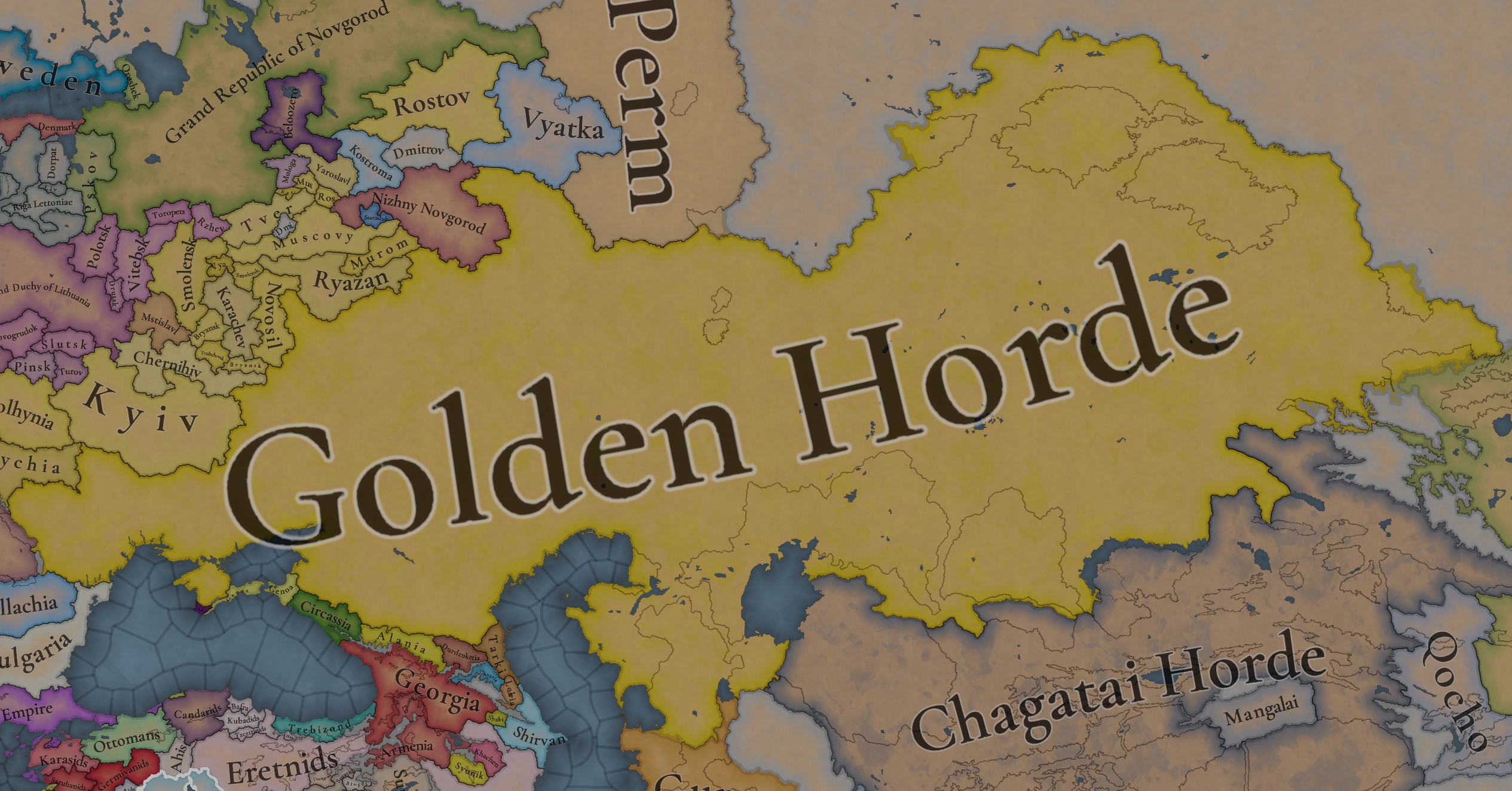
A glorious, Golden Horde! It is at its power peak, under the reign of Uzbeg Khan, so it's a much more menacing presence for its neighbors. However, it has its some internal issues that need to be managed, as you’ll notice in some of the maps, and in the future when we talk about the content for Hordes. The Golden Horde also heads its own IO, the Tatar Yoke, as shown in a previous Tinto Maps:

Tatar Yoke.jpg

We have already corrected the Ruthenian countries that are under the Horde’s Yoke, although we still have to correct the Russian principalities, which will be done in the corresponding Tinto Maps review. We’re also aware that we need to improve a bit the coloring of the IO, to mark not only the Golden Horde as the overlord of these countries, but also that Muscovy holds the title of the Grand Principality of Vladimir, which makes it the ‘enforcer’ of the Yoke. These fixes are also planned to be done in a few weeks.

Societies of Pops:
Societies of Pops.jpg

Societies of Pops 2.jpg .jpg

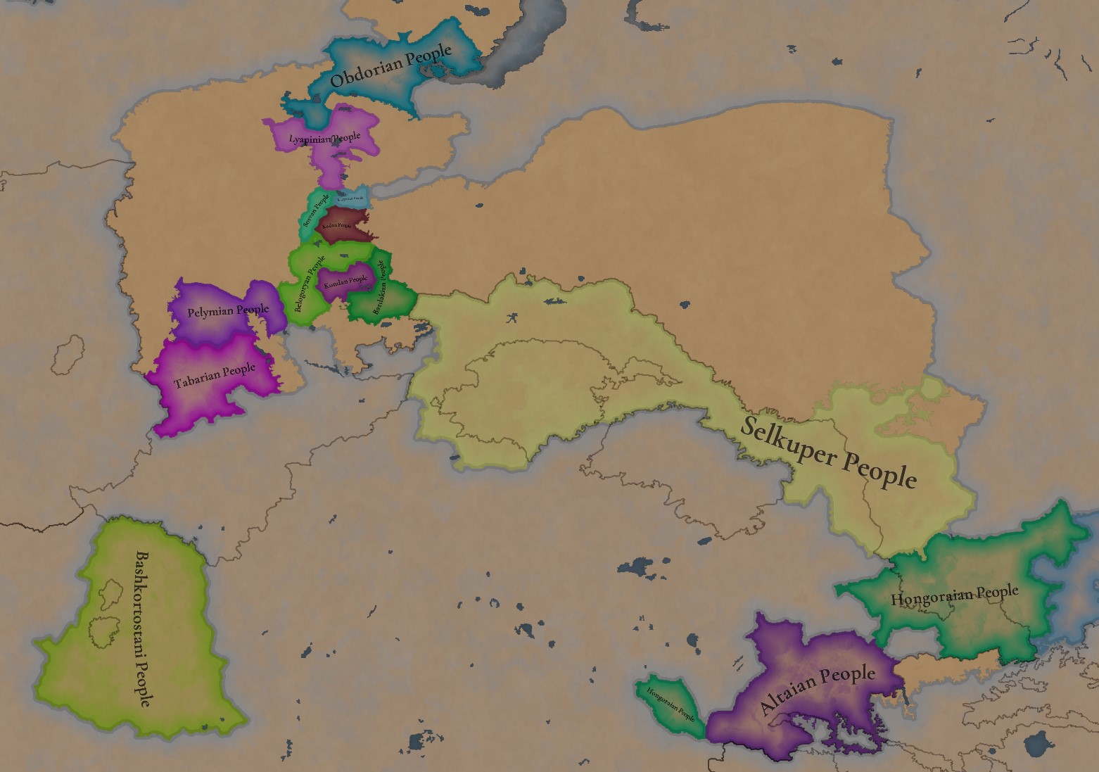
A bit up to the north, we have some Societies of Pops! This means that the territory of Western Siberia won’t be empty land, but will be populated by these people, which can be interacted with.

BTW, I’m not showing this week a dynasty map because, well, only the Borgijin dynasty rules over the lands of the Golden Horde, of course!


Locations:
Locations.jpg

Locations Western Siberia.jpg

Locations 3.jpg

Locations 4.jpg

Locations 5.jpg

Tons of locations today… You might notice that the density location is in a progression from west to east, from the most densely settled areas to the less settled ones. You may also notice that we’ve followed a design of ‘settler corridors’ in Western Siberia, setting those parts of the land that were habitable, usually on river valleys.

Provinces:
Provinces.jpg

Provinces 2.jpg


Areas:
Areas.jpg


Terrain:
Climate.jpg

Topography.jpg

Vegetation.jpg

The terrain is interesting here, as there are two main ecological areas. The first is the Steppes, Flatlands with Sparse and Grasslands vegetation, with either Cold Arid or Continental climates. And then we have the Siberian Arctics Forests, which are completely different, of course. On a note, the Urals were set as Hills, as they’re a quite settleable area, but we’ll probably make a review with your feedback, and add some mountains there.

Development:
Development.jpg

The whole region is not very developed, you might notice the difference with India, from last week’s Tinto Maps.

Harbors:
Harbors.jpg

There are some harbors in the Steppe region… In the Black Sea and Caspian Sea, of course! As usual, we’re open to feedback on this matter.

Cultures:
Cultures.jpg

Plenty of cultures! One note: Although we planned to work on the religious and cultural minorities of the region during the summer, we ended up not having enough time to add them. So what we’ll be doing today is showing the rough outline of ‘cultural spheres’, and then we’ll add the minorities during the review of the region. In that sense, feedback is very well received.

With that said the only note that needs to be made in terms of the cultural design is that we divided the Tatar cultural group into some differentiated regional cultures, being Crimean, Mishary, Kazani, and Astrakhani. We’re also aware that some of the cultures, as Mari and Chuvash, might be a bit displaced, as noted in the Russian Tinto Maps, so we’ll review and correct that with your feedback.


Religions:
Religions.jpg

Regarding Religions, the matter is a bit worse, as the big Sunni blob is just because the main religion of the Golden Horde is Islam, after the conversion of Uzbeg Khan, but that’s obviously incorrect. Also, as we have been able to forecast development time on how Pagan divisions will be during this autumn, we will make a comprehensive review of the region as well, to get a good distribution of ‘Shamanist’ Paganism, Tengrism, and Sunni Islam.

Raw Materials:
Raw Materials.jpg

Raw Materials 2.jpg

Raw Materials 3.jpg

Regarding the raw materials, the Steppes have plenty of Livestock and Horses, quite logically, although there are regions with some other goods. And up to the north, the main materials are Lumber and Fur. Apart from that, I want to mention the mineral hub in the Ural Mountains, with plenty of Copper, Iron, Gold, Lead, and Coal. That makes it a very mid and late-game interesting spot, and playing as Muscovy/Russia, I’ll tell you that you definitely want to expand into that region, as it will fulfill some of your material needs by that time.

Markets:
Markets.jpg

Markets! Big region, with lots of markets, although you may noticed that we changed the coloring of the locations that have 0% market access, which is the case in several areas. In any case, the market centers are Kaffa, Astrakhan, Saray-Jük, Kunya Urgench, Samarkand, Almaty, and Chimgi Tura. BTW, these names are much easier to notice in the game’s UI, as they’re beside the market centers:

Markets 2.jpg


Population:
Population.jpg

This week we’re showing only the country population mapmode, as there are some location numbers here and there which are failing, due to the already known issue with our pop editor (and which are on the way to be fixed). In any case, the whole population of the region is around 6.5-7M, of which around 6.3M are part of the Golden Horde. As I said, it’s a menacing country…

And that’s all for today! This is going to be my last Tinto Maps in a while, as I’ll be on vacation for 3 weeks during October (you might have noticed that I didn’t have any during summer), so one of the Content Designers in the team, @Roger Corominas , will step in and be in charge of the next 4 Tinto Maps. It’s in good hands, as Roger is an Experienced CD, who has been working and focused on Project Caesar for more than 3 years, at this point (this is why you might not know him from EU4, as other CDs in our team). In any case, he will be starting with the regions of Xinjiang, mostly ruled by the Chagatai Khanate, and Tibet.

I’ll keep reading and answering you during next week, and then I’ll be back in a month from now. See you!
 
  • 145Like
  • 48Love
  • 4
  • 3
  • 1Haha
Reactions:
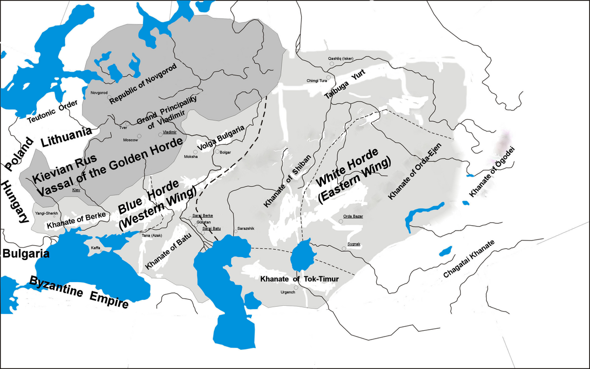
We had already gone through this yknow, that the Turkic cardinal directions which determine the "colours" of the hordes is hotly debated by historians, and you just have to pick your own interpretation, because there is no correct answer we know of.

I am only showing the territory which we know the owners of. I can't very well add nameless countries can I?
I'm just trying to understand what this map is supposed to show, It just places more doubt in me, by showing a completely different picture from the one you present.

Khanate of Bulgaria and not separate duchies
Completely different naming and borders, and I would say more big Hordes (White, Shiban, Blue, Orda and Turkmen also separated)
 
Like I said, we've gone through the naming conventions. My map is my interpretation from the Wiki and other maps. The map from "Armies of the Volga Bulgars & Khanate of Kazan" is the author's own intepretation. You should read up on the controversy about the naming conventions here:


You are placing too much emphasis on one single source. To get an idea of the narrative, you have to use multiple sources.
Again, I'm not even trying to disprove, just asking what this map means, because it contradicts the points you make.
I just trying to understand the narrative. Like okay, we have this map, what conclusions do we make from it? Look at my messages:
Not sure what you want to prove with it.
I'm just trying to understand what this map is supposed to show


I think adding some Volga Bulgar beyliks as vassals of the Batu Ulus (Blue Horde of my previous suggestion) could make sense and add a nice bit of flavour. The region is said to have been divided between vassal ulus beys (leaders of ulus') who governed the Bulgar Ulus for the Jochids. They are debated to have retained a degree of autonomy under the Mongols since the invasion, leaning more towards a recent surge in political power after regaining much of their former prosperity, with distinct principalities showing up in the first half of the 14th century.


View attachment 1217426View attachment 1217427
View attachment 1217423View attachment 1217424


View attachment 1217408
View attachment 1217410
View attachment 1217411
View attachment 1217414

Most of the information above is from the "Tatar Encyclopaedia" (2002)

View attachment 1217419

"Armies of the Volga Bulgars & Khanate of Kazan" (2013)


BTW I know one more duchy you can include: Ветлужское кугузство, capital: Шангское городище (Ветля-Шангон. Шанга-Ала), leaders: кугузы (Коджа-Яралтем, Кай, Бай-Борода)
It is a duchy of the Mari people
 
  • 1
Reactions:


I think adding some Volga Bulgar beyliks as vassals of the Batu Ulus (Blue Horde of my previous suggestion) could make sense and add a nice bit of flavour. The region is said to have been divided between vassal ulus beys (leaders of ulus') who governed the Bulgar Ulus for the Jochids. They are debated to have retained a degree of autonomy under the Mongols since the invasion, leaning more towards a recent surge in political power after regaining much of their former prosperity, with distinct principalities showing up in the first half of the 14th century.


View attachment 1217426View attachment 1217427
View attachment 1217423View attachment 1217424


View attachment 1217408
View attachment 1217410
View attachment 1217411
View attachment 1217414

Most of the information above is from the "Tatar Encyclopaedia" (2002)

View attachment 1217419

"Armies of the Volga Bulgars & Khanate of Kazan" (2013)


one more can be argued to be independent, It even has a wiki page
1731845529416.png
 
  • 2
  • 1Like
Reactions:
Do you know the Mari name for it in English? And if you have the source, would be great to look through for other states.
original text I found
Установление золотоордынского господства в Среднем Поволжье, тем не менее, не остановило процесс проникновения русских в марийские земли. Больше русских поселений появилось на Пижме и Средней Вятке, началось освоение Поветлужья, Окско-Сурского междуречья.В Верхнем Поветлужье между Галичским княжеством. Вятской Землей и Улусом Джучи, согласно «Ветлужскому летописцу», «Летописцу Солигаличского Воскресенского монастыря» и другим местным повествовательным произведениям летописного характера (все они позднего происхождения (XVII-XVIII вв.), в XII - начале XV вв. существовало Ветлужское кугузство (вождество) - союз местных марийских племен [Дементьев, 1892. С. 1-16; 1894. С 20-51; Нижегородские марийцы, 1994. С. 81-88]. Сведения указанных заволжских летописцев в целом не противоречат реальной исторической обстановке того времени [ПреобрВетлужские кугузы (вожди) (Коджа-Яралтем, Кай, Бай-Борода, Кельдибек) находились под сильным политическим влиянием соседних русских князей (галичских, костромских), руководителей Вятской земли, а также администрации Золотой Орды. Русские князья применяли традиционные методы взаимодействия с местной знатью - матримониальные союзы, подручничество, приглашение к себе марийских ополченцев для участия вмеждоусобных феодальных войнах, а также в совместных военных походах. У кугу зов была возможность лавирования между противостоявшими друг другу соседними государственными образованиями, что способствовало со¬хранению этого союза племен. Имеющиеся источники дают слабое представление о потестарной структуре Ветлужского кугузства. Однако из них становится ясно, что во главе ее был кугуз (мар. кугу оза, кугуза - «великий хозяин, старейшина»), живший в крепости (Шанга, Якшан, Юр, Булаксы). Его власть ограничивалась советом старейшин. Большим авторитетом среди местного населения пользовались языческие жрецы. По-видимому, титул кугуза не являлся наследственным. В названных источниках нет никаких намеков на то, что кугузы приходились друг другу род-ственниками, а Кельдибек, ставленник Тохтамыша и последний ветлужский князь, был избран старейшинами [Дементьев, 1892. С.1-16; 1894. С. 20-51; Летопись Солигаличского Воскресенского монастыря, 1913. С. 300-306; Нижегородские марийцы, 1904. С. 81-88].

so sources for it are «Ветлужский летописец», «Летописец Солигаличского Воскресенского монастыря» and [Дементьев, 1892. С. 1-16; 1894. С 20-51; Нижегородские марийцы, 1994. С. 81-88]
I doubt it is in English

For the first one, I found a video called Searching for him. In this video there are documents about it but as I understand nothing truly valuable survived.

last one is this: Дементьев Д.П. Краткие сведения о Кажировской пустыни, I cant find pdf of it

one more quote with mentions of Mari principality
В 1247 году великий князь Александр Невский заключил мир с марийцами и повелел производить торговлю и обмен товаров в Шанге. Татарский хан и русские князья признали Марийское княжество и вынуждены были с ним считаться.
В 1277 году Галичский князь Давид Константинович продолжил заниматься торговыми делами с марийцами. Однако уже в 1280 году, брат Давида, Василий Константинович начал наступление на марийское княжество. В одном из сражений марийский князь Кай Хлыновский был убит, а княжество обязали платить дань Галичу. Новый князь мари, оставаясь данником Галичских князей, возобновил города Шангу и Якшан, заново укрепил Булаксы и Юр (Булаксы — с. Одоевское Шарьинского района, Юр — поселение на р. Юрьевке близ г. Ветлуги).
В первой половине XIV века русские князья с марийцами активных боевых действий не вели, привлекали на свою сторону марийскую знать, активно способствовали распространению среди мари христианства, поощряли переход на марийские земли русских поселенцев.
В 1345 году Галичский князь Андрей Семенович (сын Симеона Гордого) женился на дочери марийского князя Никиты Ивановича Байбороды (марийское имя Ош Пандаш). Ош Пандаш принял православие, а выданная им за Андрея дочь, крещенна Марией. На свадьбе в Галиче была вторая жена Симеона Гордого – Евпраксия, на которую по легенде, марийский колдун из-за зависти навел порчу. Что, однако, обошлось марийцам, без каких либо последствий.
Ситуация меняется в 1351 году, Галичский князь (с 1346 года) Андрей Фёдорович направил свою дружину против марийского княжества. Байборода объединил разрозненные марийские племена и привлёк на свою сторону татар. Столкновения продолжались 19 лет. Дружина Андрея Фёдоровича, измотанная в междоусобных распрях русских князей, была сильно ослаблена, и в нескольких сражениях разбита марийцами. Андрей Фёдорович в 1372 году бежал в Переяславль — Залесский, марийское княжество становится независимым. А марийская знать всё сильнее ориентируется на татар.

but yeah, it is all based on not digitalised sources.

but I think this can be found somewhere
В 1345 году Галичский князь Андрей Семенович (сын Симеона Гордого) женился на дочери марийского князя Никиты Ивановича Байбороды (марийское имя Ош Пандаш). Ош Пандаш принял православие, а выданная им за Андрея дочь, крещенна Марией
 
Last edited:
  • 1
Reactions:


I think adding some Volga Bulgar beyliks as vassals of the Batu Ulus (Blue Horde of my previous suggestion) could make sense and add a nice bit of flavour. The region is said to have been divided between vassal ulus beys (leaders of ulus') who governed the Bulgar Ulus for the Jochids. They are debated to have retained a degree of autonomy under the Mongols since the invasion, leaning more towards a recent surge in political power after regaining much of their former prosperity, with distinct principalities showing up in the first half of the 14th century.


View attachment 1217426View attachment 1217427
View attachment 1217423View attachment 1217424


View attachment 1217408
View attachment 1217410
View attachment 1217411
View attachment 1217414

Most of the information above is from the "Tatar Encyclopaedia" (2002)

View attachment 1217419

"Armies of the Volga Bulgars & Khanate of Kazan" (2013)


The next one, the Crimean Ulus
Wiki page

translation:
The Crimean ulus was formed on the territory of the Crimean peninsula under Khan Batu. As in the rest of the Golden Horde, the few Mongol conquerors were assimilated by the local population within one generation[1][2][3]. In Crimea, this included both settled residents and residents of the steppe part of Crimea; the main language of the administration from the end of the 13th century was one of the Turkic languages - the Polovtsian language, which would form the basis of the Crimean Tatar language[4]. Eski-Saray Mosque in Crimea, 14th century The Turkification of Crimea began during the Khazar Khaganate, although the first Turks appeared in Crimea in the 6th century, during the conquest of Crimea by the Turkic Khaganate[5]. Before the arrival of the Mongols, the Polovtsian language became not only the lingua franca on the peninsula, but also the language of the plebs in some cities (note: the city of Kyryk-Or and others). During the Golden Horde era, the process of Turkification intensified[6]. Most of the southern coast of Crimea was occupied by the Genoese, and then by the Venetians, who received a label for the right to use the territory (see concession). The Genoese began building trading fortresses through which they carried out trade (including slaves)[1]. On the southern slopes of the Crimean Mountains was the principality of Theodoro, formed during the secession of Byzantium's trading colonies in Crimea. Khan Uzbek Mosque in Crimea Around the second half of the 13th century, active Tatar urban development began in the Crimean ulus. The main style of the cities became the Asia Minor style, characteristic of the Golden Horde Tatar architecture[1].
Отправить отзыв
 
original text I found


so sources for it are «Ветлужский летописец», «Летописец Солигаличского Воскресенского монастыря» and [Дементьев, 1892. С. 1-16; 1894. С 20-51; Нижегородские марийцы, 1994. С. 81-88]
I doubt it is in English

For the first one, I found a video called Searching for him. In this video there are documents about it but as I understand nothing truly valuable survived.

last one is this: Дементьев Д.П. Краткие сведения о Кажировской пустыни, I cant find pdf of it

one more quote with mentions of Mari principality


but yeah, it is all based on not digitalised sources.

but I think this can be found somewhere

Found some pretty good info here:
 
I think development in the region needs changes. Maybe also give them mechanics of declining cities after collaps of Silk Road (rise of Ming and development of sea trade) and Timurs campains?
Map of Golden Horde cities:
1732266878199.png
 
  • 3
  • 2Like
Reactions:


I think adding some Volga Bulgar beyliks as vassals of the Batu Ulus (Blue Horde of my previous suggestion) could make sense and add a nice bit of flavour. The region is said to have been divided between vassal ulus beys (leaders of ulus') who governed the Bulgar Ulus for the Jochids. They are debated to have retained a degree of autonomy under the Mongols since the invasion, leaning more towards a recent surge in political power after regaining much of their former prosperity, with distinct principalities showing up in the first half of the 14th century.


View attachment 1217426View attachment 1217427
View attachment 1217423View attachment 1217424


View attachment 1217408
View attachment 1217410
View attachment 1217411
View attachment 1217414

Most of the information above is from the "Tatar Encyclopaedia" (2002)

View attachment 1217419

"Armies of the Volga Bulgars & Khanate of Kazan" (2013)


About Qashan Duchy. It says it was once a Bolgar duchy. I managed to find info about the Bolgar duchy on Russian Wikipedia

There is A LOT of information there. I don't know how useful for you it will be, but still a great read
 
  • 1
  • 1
Reactions:
Tons of locations today… You might notice that the density location is in a progression from west to east, from the most densely settled areas to the less settled ones. You may also notice that we’ve followed a design of ‘settler corridors’ in Western Siberia, setting those parts of the land that were habitable, usually on river valleys.

Provinces:
View attachment 1194081
View attachment 1194082

Areas:
View attachment 1194083
Hello, thank you for your efforts. I would like to say that I am very annoyed by the Russian names of settlements and regions even before these names appeared in the Russian language and before these lands were captured by the Russians.

For example, the historical and local name of Kuznetsk (Novokuznetsk) is Aba-Tura (this is what local peoples call it: Altai, Shor, Khakas people, and so on).
Also, the historical name of Omsk is Ombı, and Tomsk is Tom-Tura, and Tobolsk is simply Tobol. (In general, there is a big hint - if the name of a city or region ends with -sk, then it came from Russian after the capture of these lands. The Russian suffix -sk is an abbreviation of the ending -skiy (-skaya, -skoye), which corresponds to -ian in English, eg. Novorossiyskoye - Novorossian).
Also, the real name of the Dudinka region is Tutin (nenets name), and the real name of Zmeinogosk is Jilan (Jelian).
Also, the correct name of the region Bashkiria is the word Bashgurd (by the way, I am from this region). The variant Bashkiria is Russian and appeared after the Russians captured this area.

1733390393368.png

1733388703409.png

Cultures:
View attachment 1194089
With that said the only note that needs to be made in terms of the cultural design is that we divided the Tatar cultural group into some differentiated regional cultures, being Crimean, Mishary, Kazani, and Astrakhani. We’re also aware that some of the cultures, as Mari and Chuvash, might be a bit displaced, as noted in the Russian Tinto Maps, so we’ll review and correct that with your feedback.
Also, I want to say there is not nation and culture named Yerle Qalıq (which means "Local People" in Bashkir, compare with Turkish "Yerli Halk"). The name of this Culture is Siberian.
 
  • 1
Reactions:
Hello, thank you for your efforts. I would like to say that I am very annoyed by the Russian names of settlements and regions even before these names appeared in the Russian language and before these lands were captured by the Russians.

For example, the historical and local name of Kuznetsk (Novokuznetsk) is Aba-Tura (this is what local peoples call it: Altai, Shor, Khakas people, and so on).
Also, the historical name of Omsk is Ombı, and Tomsk is Tom-Tura, and Tobolsk is simply Tobol. (In general, there is a big hint - if the name of a city or region ends with -sk, then it came from Russian after the capture of these lands. The Russian suffix -sk is an abbreviation of the ending -skiy (-skaya, -skoye), which corresponds to -ian in English, eg. Novorossiyskoye - Novorossian).
Also, the real name of the Dudinka region is Tutin (nenets name), and the real name of Zmeinogosk is Jilan (Jelian).
Also, the correct name of the region Bashkiria is the word Bashgurd (by the way, I am from this region). The variant Bashkiria is Russian and appeared after the Russians captured this area.

View attachment 1226438
View attachment 1226427

Also, I want to say there is not nation and culture named Yerle Qalıq (which means "Local People" in Bashkir, compare with Turkish "Yerli Halk"). The name of this Culture is Siberian.
I think they dislike general area names. Siberian can also be a Slavic Siberian

but how about Seber? It is a Tatar variation of "Siberian"
 
  • 1Like
Reactions:
So if say that correct then we need to change Alaskan culture becouse there is Slavic of Alaska. And Also we have in this game Crimean culture (for Crimean Tatars), i think it is possible also Siberian culture (for Siberian Tatars)
 
I think they dislike general area names. Siberian can also be a Slavic Siberian

but how about Seber? It is a Tatar variation of "Siberian"
Siberian Tatars call Siberia territory (and themselves) Seber, Sibir and Sıbır (Sybyr) depending on dialect, so i think the word Sibir is most common
 
so i think the word Sibir is most common
I disagree here. I can not find common usage of Sibir. However Себер or "Seber" I can find in Wikipedia about people (Siberian Tatars, Себер татарлар, Seber Tatarlar) or about language: "Себертатарца". In the Swadesh table, it is also written as Seber Tatar Tele.

I also found this article on the Tatar language where Seber is used as a transcription

So if say that correct then we need to change Alaskan culture becouse there is Slavic of Alaska. And Also we have in this game Crimean culture (for Crimean Tatars), i think it is possible also Siberian culture (for Siberian Tatars)
Alaskan Creoles (Russian: Креолы Аляски) are known as Russian Creoles (Russian: Креолы, romanized: Kreoly).
I do not see them called just Alaskan. Still, I do not see a problem with not using the term when there is a different word that can be used
 
I disagree here. I can not find common usage of Sibir. However Себер or "Seber" I can find in Wikipedia about people (Siberian Tatars, Себер татарлар, Seber Tatarlar) or about language: "Себертатарца". In the Swadesh table, it is also written as Seber Tatar Tele.

I also found this article on the Tatar language where Seber is used as a transcription
You are right, sir, but still, it depends on dialect, for example, the most popular Siberian Tatar youth organization says:
1733410726726.png


The self-designation of our people is Sıbırlar (or Sybyrlar, depending on alphabet) - Siberians, in the scientific community the ethnonym Siberian Tatars is used. Sybyrs are Asians, they are the aboriginal inhabitants of Siberia.

Also, the most popular Siberian Tatar website is sybyrlar.narod ru
 
  • 2
Reactions:
As I was doing some further research for the relationship between Georgia and the Latin merchants of Italy in my old post, I came across this wonderful PhD Thesis by Evgeny Khvalkov called "The Colonies of Genoa in the Black Sea Region: Evolution and Transformation".

I highly recommend reading the thesis. Just by skimming through the text, I was shocked by the amount of information it contained.

I feel like you guys are going to find the document more useful than I am, as the information written here mostly concerns Crimea and the Ukraine, hence this post here.


  • 1
  • 1Love
Reactions:
View attachment 1229278
Proposal for Mordvins with the new locations from TM8 feedback.
Kadom, Temnikov, Shatsk, Enkai, and other beyliks joined Kasimov for the Kasimov Khanate (or were annexed) in the XV century. Moscow principality gave this territory to Kasim, the son of Tatar Khan. All those cities have had a sizable Tatar population even in 19th century (). I find it hard to believe those lands were inhabited by a Slavic population. I think Tatars lived there before this land was transferred.

On a side note, Yelatma(near Kadom) was bought by Moscow principlaity in 1381 from Mishary Tatars
 
  • 2Like
Reactions:
Kadom, Temnikov, Shatsk, Enkai, and other beyliks joined Kasimov for the Kasimov Khanate (or were annexed) in the XV century. Moscow principality gave this territory to Kasim, the son of Tatar Khan. All those cities have had a sizable Tatar population even in 19th century (). I find it hard to believe those lands were inhabited by a Slavic population. I think Tatars lived there before this land was transferred.

On a side note, Yelatma(near Kadom) was bought by Moscow principlaity in 1381 from Mishary Tatars
Most of those settlement such as Shatsk didn't exist yet. Gorodets Meshchersky was recently taken from Ryazan principality and granted to the Meshchera princes, so I doubt Tatars would have constituted a significant majority yet at this time. Temnikov nor Kadom were significant seats of Tatar power in the area yet, Narovchat served that role.
 
Most of those settlement such as Shatsk didn't exist yet. Gorodets Meshchersky was recently taken from Ryazan principality and granted to the Meshchera princes, so I doubt Tatars would have constituted a significant majority yet at this time. Temnikov nor Kadom were significant seats of Tatar power in the area yet, Narovchat served that role.
Still, none of that proves that the lands were inhabited by Slavic people rather than at least Erzya and Moksha.