• We have updated our Community Code of Conduct. Please read through the new rules for the forum that are an integral part of Paradox Interactive’s User Agreement.

Tinto Maps #20 - 27th of September 2024 - The Steppes

Hello, and welcome one more week to the weekly encounter for map lovers! This week it’s also directed at horse lovers because we will be looking at the Eurasian Steppes, plus the Urals! So let’s start with the maps without further ado.

Countries:
Countries.jpg

Colored Wastelands.jpg

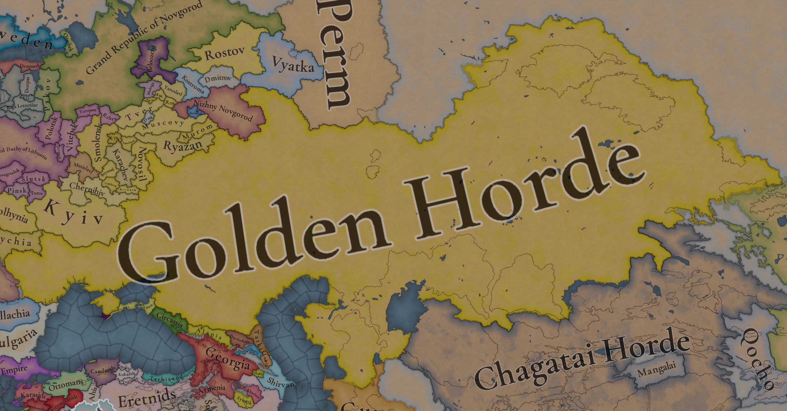
A glorious, Golden Horde! It is at its power peak, under the reign of Uzbeg Khan, so it's a much more menacing presence for its neighbors. However, it has its some internal issues that need to be managed, as you’ll notice in some of the maps, and in the future when we talk about the content for Hordes. The Golden Horde also heads its own IO, the Tatar Yoke, as shown in a previous Tinto Maps:

Tatar Yoke.jpg

We have already corrected the Ruthenian countries that are under the Horde’s Yoke, although we still have to correct the Russian principalities, which will be done in the corresponding Tinto Maps review. We’re also aware that we need to improve a bit the coloring of the IO, to mark not only the Golden Horde as the overlord of these countries, but also that Muscovy holds the title of the Grand Principality of Vladimir, which makes it the ‘enforcer’ of the Yoke. These fixes are also planned to be done in a few weeks.

Societies of Pops:
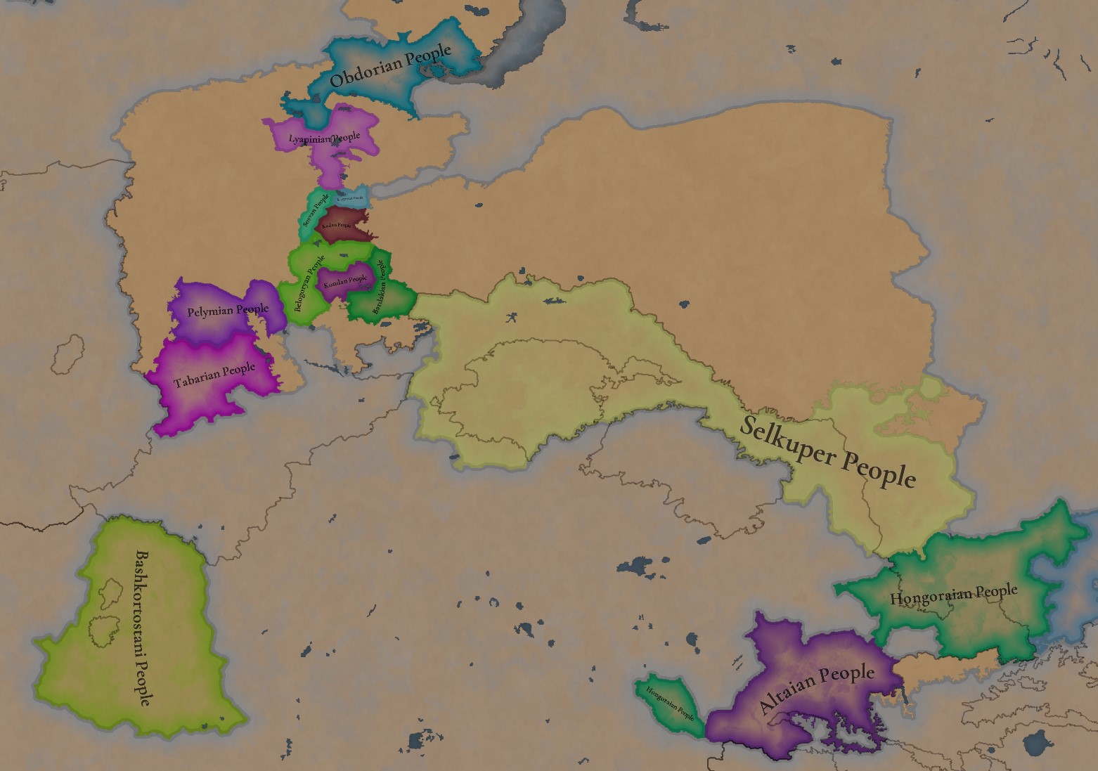
Societies of Pops.jpg

Societies of Pops 2.jpg .jpg

A bit up to the north, we have some Societies of Pops! This means that the territory of Western Siberia won’t be empty land, but will be populated by these people, which can be interacted with.

BTW, I’m not showing this week a dynasty map because, well, only the Borgijin dynasty rules over the lands of the Golden Horde, of course!


Locations:
Locations.jpg

Locations Western Siberia.jpg

Locations 3.jpg

Locations 4.jpg

Locations 5.jpg

Tons of locations today… You might notice that the density location is in a progression from west to east, from the most densely settled areas to the less settled ones. You may also notice that we’ve followed a design of ‘settler corridors’ in Western Siberia, setting those parts of the land that were habitable, usually on river valleys.

Provinces:
Provinces.jpg

Provinces 2.jpg


Areas:
Areas.jpg


Terrain:
Climate.jpg

Topography.jpg

Vegetation.jpg

The terrain is interesting here, as there are two main ecological areas. The first is the Steppes, Flatlands with Sparse and Grasslands vegetation, with either Cold Arid or Continental climates. And then we have the Siberian Arctics Forests, which are completely different, of course. On a note, the Urals were set as Hills, as they’re a quite settleable area, but we’ll probably make a review with your feedback, and add some mountains there.

Development:
Development.jpg

The whole region is not very developed, you might notice the difference with India, from last week’s Tinto Maps.

Harbors:
Harbors.jpg

There are some harbors in the Steppe region… In the Black Sea and Caspian Sea, of course! As usual, we’re open to feedback on this matter.

Cultures:
Cultures.jpg

Plenty of cultures! One note: Although we planned to work on the religious and cultural minorities of the region during the summer, we ended up not having enough time to add them. So what we’ll be doing today is showing the rough outline of ‘cultural spheres’, and then we’ll add the minorities during the review of the region. In that sense, feedback is very well received.

With that said the only note that needs to be made in terms of the cultural design is that we divided the Tatar cultural group into some differentiated regional cultures, being Crimean, Mishary, Kazani, and Astrakhani. We’re also aware that some of the cultures, as Mari and Chuvash, might be a bit displaced, as noted in the Russian Tinto Maps, so we’ll review and correct that with your feedback.


Religions:
Religions.jpg

Regarding Religions, the matter is a bit worse, as the big Sunni blob is just because the main religion of the Golden Horde is Islam, after the conversion of Uzbeg Khan, but that’s obviously incorrect. Also, as we have been able to forecast development time on how Pagan divisions will be during this autumn, we will make a comprehensive review of the region as well, to get a good distribution of ‘Shamanist’ Paganism, Tengrism, and Sunni Islam.

Raw Materials:
Raw Materials.jpg

Raw Materials 2.jpg

Raw Materials 3.jpg

Regarding the raw materials, the Steppes have plenty of Livestock and Horses, quite logically, although there are regions with some other goods. And up to the north, the main materials are Lumber and Fur. Apart from that, I want to mention the mineral hub in the Ural Mountains, with plenty of Copper, Iron, Gold, Lead, and Coal. That makes it a very mid and late-game interesting spot, and playing as Muscovy/Russia, I’ll tell you that you definitely want to expand into that region, as it will fulfill some of your material needs by that time.

Markets:
Markets.jpg

Markets! Big region, with lots of markets, although you may noticed that we changed the coloring of the locations that have 0% market access, which is the case in several areas. In any case, the market centers are Kaffa, Astrakhan, Saray-Jük, Kunya Urgench, Samarkand, Almaty, and Chimgi Tura. BTW, these names are much easier to notice in the game’s UI, as they’re beside the market centers:

Markets 2.jpg


Population:
Population.jpg

This week we’re showing only the country population mapmode, as there are some location numbers here and there which are failing, due to the already known issue with our pop editor (and which are on the way to be fixed). In any case, the whole population of the region is around 6.5-7M, of which around 6.3M are part of the Golden Horde. As I said, it’s a menacing country…

And that’s all for today! This is going to be my last Tinto Maps in a while, as I’ll be on vacation for 3 weeks during October (you might have noticed that I didn’t have any during summer), so one of the Content Designers in the team, @Roger Corominas , will step in and be in charge of the next 4 Tinto Maps. It’s in good hands, as Roger is an Experienced CD, who has been working and focused on Project Caesar for more than 3 years, at this point (this is why you might not know him from EU4, as other CDs in our team). In any case, he will be starting with the regions of Xinjiang, mostly ruled by the Chagatai Khanate, and Tibet.

I’ll keep reading and answering you during next week, and then I’ll be back in a month from now. See you!
 
  • 147Like
  • 48Love
  • 5
  • 3
  • 1Haha
Reactions:
Certain locations in the region after the feedback still have obvious Slavic names.​
That really breaks immersion and flavour to quite a few people, so I tried to improve it a bit.
And also improved my own approach to this kind of suggestions.
Following up on the Northern Caucasus location naming suggestions, here are some improved ideas for the Don-Volga part of the Steppes.

Certain locations in the region after the feedback still have obvious Slavic names.
That really breaks immersion and flavour to quite a few people, so I tried to improve it a bit.
And also improved my own approach to this kind of suggestions.

THIS TIME I:
  • avoided pure hydronyms as much as possible,
  • used better maps (Google) to look for alternative settlements nearby with either Turkic/Circassian origin or at least not-so-obvious Slavic names,
  • used Circassian names and sources of those settlements or some information about previous settlements from Wiki,
  • and the most important – used historic maps of the region.

Special thanks to the forum for cooperation.

LEGEND
Known pre-1337 Horde cities
Settlements from the
XV – XVII century maps
Previous or local settlement names
Nearby settlements with Turkic origin or neutral name
Local (Turkic)
river names
1746976458020.png
1746975970586.png
1746976049215.png
1746976184132.png
1746977060185.png
For most of them locations are probable, mentions in the chronicles are matched with big archaeological sites.​
The second row with a question mark means my suggestion for better spelling adaptation.
Like Boletecoi Boletekoy.
Also used one modern map from multiple Circassian sources.​
Wikipedia and local historic sources​
Google Maps used​
Used when no better options were found​

MAP
LowerVolgaDon_Corr.png
LowerVolgaDon.png


I used standard transliteration from the Cyrillic alphabet, but maybe better to use Turkic-ish spelling: Şanjir, Bjedygu-Kal, Yaşalta etc.?
I hope the devs will handle it better.

The most important thing – of course we cannot locate the exact places from those old maps, so this is some approximation in any case, I am aware of it.
Further details in notes.
  • Bzhedygu-Kal – previous Circassian name of Yekaterinodar.
  • Vassanar, Codicoi, Cogia, Cremuch, Acua, Tzerkas, Zingis, Boletecoi, Azaraba, Besinda, Nabars, Achas, Azabar, Scosna, Tuia – chosen approximately based on main rivers, seas, mountains and general setting on multiple maps.
  • Pexo/Peso/Pesso – different variations on different maps through time. Or can be Azara.
  • Lysychansk -> Bayrak (previous early Cossack name was Lysychiy Bayrak, and 'bayrak' is a Turkic word, so get rid of the adjective and we have a good name).
  • Luhansk -> Verhunka (the earliest Cossack settlement there, Turkic root Verhun, so could be also Verhun).
  • Posad -> Kayaly/Kayala. It is a river known from the Rus chronicles in Azov Steppe and could be associated with the Kalmius river. Also Posad is just a generic term for a settlement. Obviously it represents modern-day Donetsk, but all of my Donetsk friend were surprised to see it because they did not know (neither Google) about any kind of 'posad' in the history of Donetsk.
  • Special funny note about Yebok Wiki page Ебок. For those, who do not understand, it was literally called a Fucking Settlement (in Russian) by the Don Cossacks.
  • Earlier maps were prioritised.
  • I did not use XVIII century maps a lot because the current settlements were mostly established around that time, so it is not a big difference from Google maps suggestions.
  • One 'modern' map of Circassia in 1450 is from multiple Circassian sources.
  • Those names I used were mentioned in multiple maps.

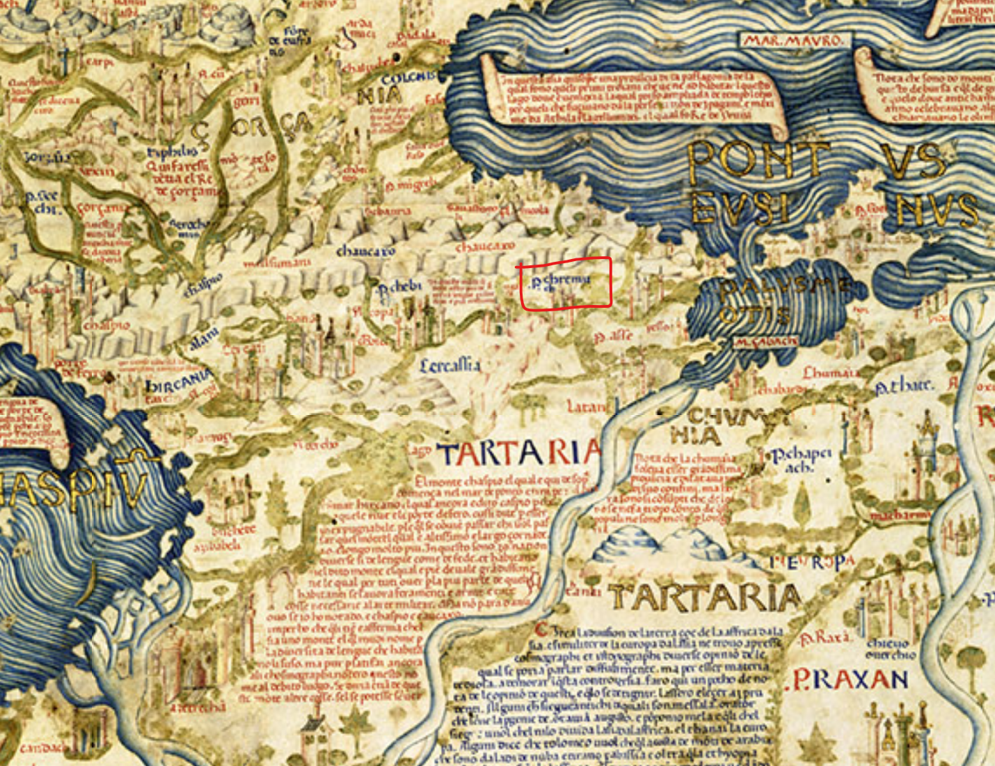
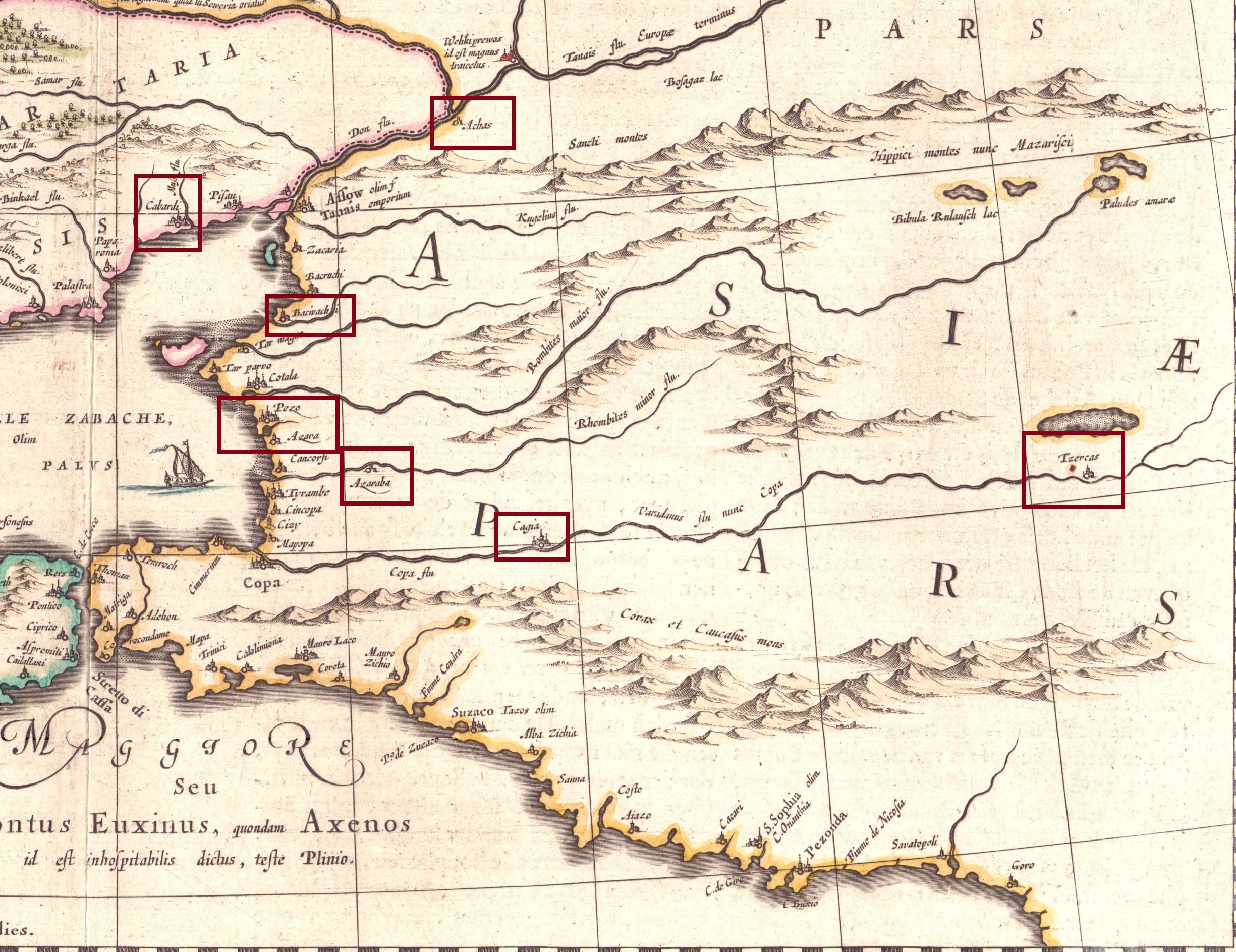
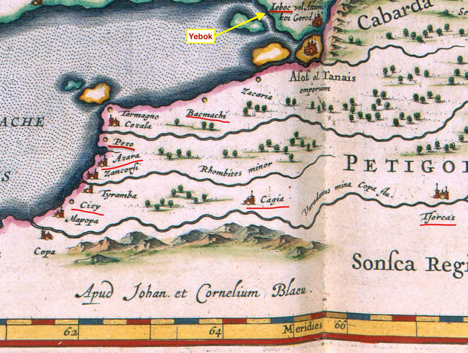
I highlighted the respective settlements on those maps.

Fra Mauro 1459
Vesconte 1318
Canepa 1489
1459_FraMauro.png
1318_Vesconte.jpg
1489_Canepa.png


Gastaldi 1548
De Jode 1579
Keller 1590
1548_Gastaldi.jpg
1579_DeJode.png
1590_Keller.png


Mercator Atlas 1590s
Mercator 1595
Mercator 1636
1595_MercatorAtlas_2.png
1595_Mercator.png
1636_Mercator.jpg


Hagen 1638
Cantelli 1684
Circassian source 1450
1638_HagenAtlas.png
1684_Cantelli.png
Circassia_1450.png


Similar rework of the Ukrainian Steppe is underway!
 
Last edited:
  • 4Love
  • 3Like
Reactions:
The Siberian Tatars, 'Yerle Qaliq' is their endonym: https://en.wikipedia.org/wiki/Siberian_Tatars
Yerle Qaluq means literally "Local People" it does not make any sense. It is a recent used name thanks to post-Stalin migrations to distinguish themselves from other Tatar-called-groups. These are Syberian Tatars.
Tatar naming is a historical nightmare itself. In Turkish history we named mongol invaders, but later Turkic migrants as well. Tatar can be Volga Tatar, Kazan Tatar, Idil Tatar, Crimean Tatar, Nogays (essentially Kipchaks), are all named Tatars as well as non-Mongol Turkic invaders who served Mongol khans.
This is a bit confusing topic, and I am not a Historic scientist myself, but Yerle Qaluq is not a proper name for these people, I can say that much wth confidence.
 
  • 3
  • 2Like
Reactions:
I think the question of Vetluga principality should be reassessed. From what I managed to glean from the sources I read is that there may have been some form of proto-state in the area nominally subordinate to the Golden Horde. At least the Vetluga Mari feuded with the Galich people a lot that much we know. However I am unsure of the accuracy of some of the sources.
 
  • 3Like
Reactions:
So I guess the full picture is: Golden hode transformed into the county of Durdzuketia and lost a war to Bulgaria, becoming its vassal. And only than it exploded, creating new nations one by one.

View attachment 1293415

It definitely outside of the possibility range.

So my question is, how did that conversion to a county happened?
I think some eu4 mod did what I suggested that during a GH collapse scripted tags would pop out, I think it was Ante Bellum if I'm not wrong
 
  • 1Like
Reactions:
Following up on the Northern Caucasus location naming suggestions, here are some improved ideas for the Don-Volga part of the Steppes.
Following up on the Volga-Don location naming suggestions, here are some improved ideas for the Wild Fields (Ukrainian Steppe) region.

Certain locations in the region have obvious Slavic names.
That really breaks immersion and flavour to quite a few people, so I tried to improve it a bit.
And also improved my own approach to this kind of suggestions.

THIS TIME I:
  • avoided hydronyms as much as possible,
  • used better maps (Google) to look for alternative settlements nearby with either Turkic/Circassian origin or at least not-so-obvious Slavic names,
  • used historical Crimean Tatar names and sources of those settlements or some information about previous settlements, rivers, their etymology,
  • and the most important – used historic maps of the region.

LEGEND
Golden Horde cities
Settlements from the XV – XVIII century maps
Location names in the Crimean Tatar language
Previous or local settlement names
Nearby settlements with Turkic or neutral name
Turkic
river names
Correct Ukrainian spelling
1747488927249.png
1747516597432.png
1747431625485.png
1747431210160.png
1747431249146.png
1747431294689.png
1747431747670.png
Locations are probable,
mentions in chronicles are matched with archaeological sites.​
Old maps used.
Spelling standartised (but Crimean spelling needs to be revised).​
Old maps and Crimean sources used.​
Local historic sources​
Google Maps used​
Used when no better options were found​
Both starting locations and for the dynamic naming​


MAPS
Ukraine_Corr.png
Ukraine_UA.png


This time I also used the Crimean Tatar alphabet to spell those locations for 1337 (my suggestions need to be revised especially k/q since I have no background with this):
1747385937169.png


IMPORTANT: since most of those maps were made by western Europeans via Polish perception of Tatar / Ukrainian spelling (or even also via Ruthenian between Tatar and Polish), you can find a lot of spelling inconsistency, so I use standard Ukrainian names for dynamic naming and historical/actual Crimean Tatar names where possible for 1337.

Tatar Naming suggestion in green / Ukrainian naming suggestion in yellow:
  • Buzhskyi, Drahushiv, Zavallia, Torhovytsia, Krasnyi Kut (please, correct Ukrainian spelling).
  • Also for 1337 Torhovytsia -> Yabu and Vasylivka (near Zaporizhzhia) -> Yedi Cami and Orhei -> Yangi-Şehr (big archaelogical sites of the Golden Horde cities of the XIV century, supposed to have had these names; note you have another Vasylivka in Donbas; note that that Vasylivka location includes two archaelogical sites of large Horde cities - Yedi Cami and Mamay-Saray – probable capital of the Mamay Horde).
  • Odessa -> Kocabey / Kochubiy (multiple mentions on old maps, the settlement appeared long before it was named Odesa; Kocabey is the correct Crimean Tatar spelling, Ukrainian can be Kochubiy/Kochubey/Kotsubiv; lastly, Odessa is Russian spelling with -ss-).
    Kocabey.png

  • Kominternivske -> Teligol / Kordon (Kominternivske is a communist name, so I have chosen a nearby town called Kordon for Ukrainian naming; and Teligol was on multiple old maps).
  • Voznesensk -> Keşeni / Syni Vody (multiple mentions of Chryzkeszeni and Szinouoda settlements on old maps in the area of Voznesensk-Pervomaisk; keşeni means 'field mosque' in Tatar and it is unknown what exactly that Chryz- meant, to it can be just Keşeni; Szinouoda is obviously Syni Vody, the place of the 1362 battle, currently called Syniukha).
  • Nova Odesa -> Çapçaqlı / Andriiv (multiple mentions on old maps in the very same place; also since Odesa is not very relevant for the game, Nova Odesa is even less relevant).
  • Nikolaev -> Vithold Hammami / Vynohradna Krynytsia (both mentions on old maps, former Vitautas castle and trading post, mentioned as Balneum Vitoldi in Latin; lastly, Nikolaev is Russian spelling).
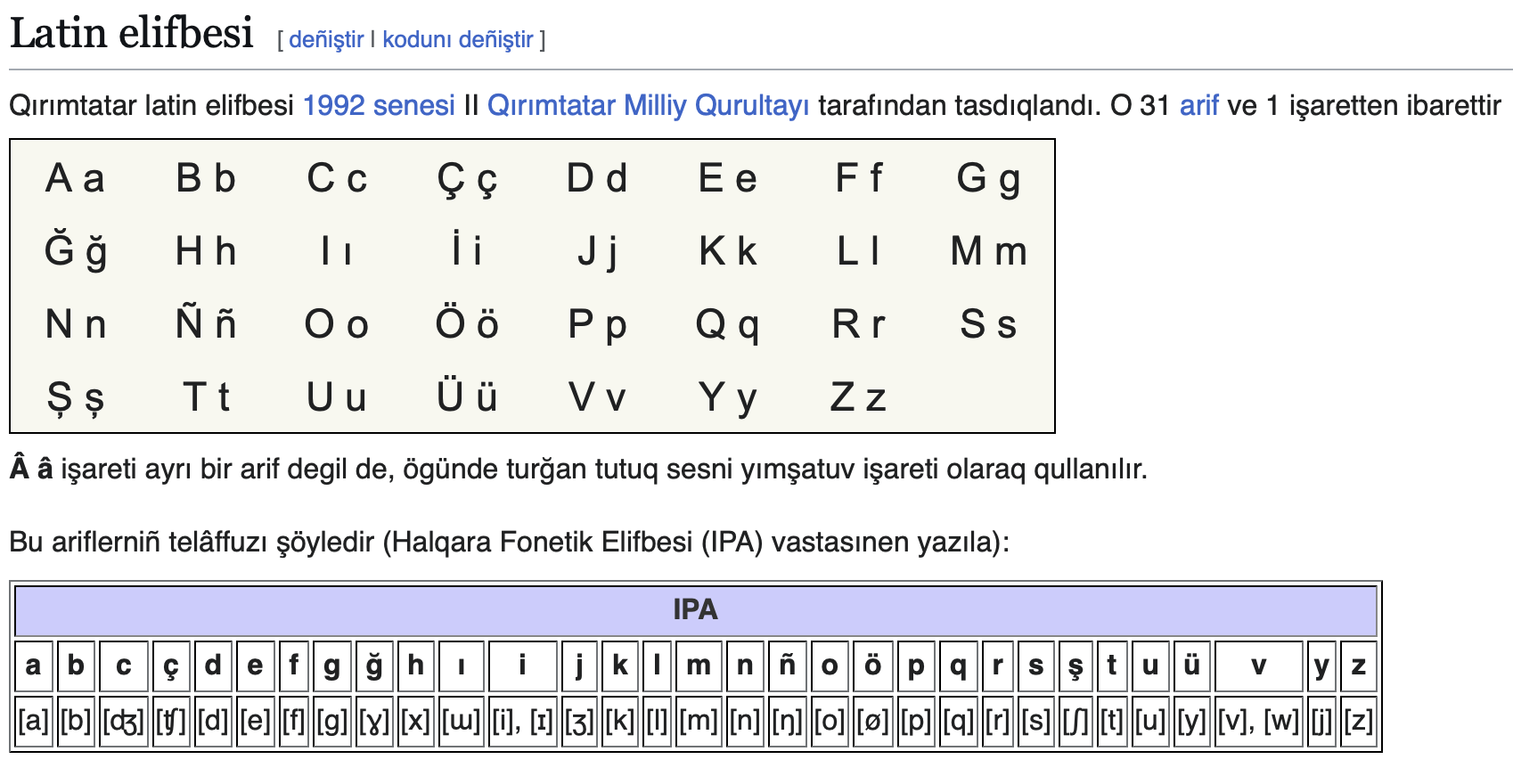
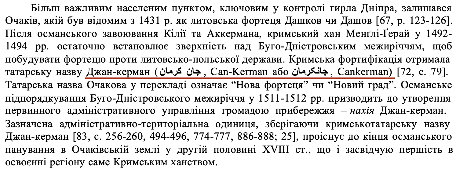
  • Ochakov -> Cankerman / Dashkiv/Ochakiv (multiple mentions on old maps; Dashkiv was the earliest name, mentioned in early Polish documents (source, p.124); sometimes maps showed both Dashiv and Ochakiv, that was an early maps error; Cankerman (Dzhan-Kerman) is correct initial Crimean Tatar name, reflected by Dziankermenda name in multiple old maps; lastly, Ochakov is Russian spelling).
1747423822181.png
1747423890197.png
  • Kherson -> Tehin / Tiahynka/Kherson (multiple mentions on old maps, Tehin is Turkicised, Tiahynka is Ukrainian name).
  • Kropyvnytskyi -> Ingul / Inhuletska Sloboda (Kropyvnytskyi is a recent name; the first Cossack settlements (one of them was Inhuletska Sloboda) were named after the major river Inhul even before it was named Yelysavet, mentioned on old maps (e.g. Inhul-horod); Ingul has also Turkic origin).
  • Numerous unreadable locations along the Dnipro -> İslam Kermen, Ğazı Kermen, Rohat Kermen, Tencay, / Oleshky, Beryslav, Kakhovka, Dudchany (Tatar towns documented on numerous old maps; Ukrainian names are much more relevant and short; e.g. Kakhovka was previously Islam-Kermen and Beryslav was Gazi-Kermen).
  • Velyka Bilozerka -> Aççı Su / Dniprovka (Aççı Su is the Crimean Tatar name for the Bilozerka river; and Dniprovka for Ukrainian is just shorter).
  • Lykhivka -> Saqsagan / Zhovti Vody (For Ukrainian name Zhovti Vody is far more relevant historically due to the famous 1648 battle, the place is also mentioned on old maps; also Saksahan is a local river with an obvious Tatar origin).
  • Ltava -> Oril / Oril (multiple mentions on old maps, also Ltava was ancient Poltava).
  • Kodaky -> Kudak / Kodak (Kodaky is a modern name, I suggest using the name mostly mentioned in old maps and the old Ukrainian name instead).
  • Zaporizhzhia -> Küçük As / Kichkas (Zaporizhzhia as a location name is quite anachronistic, that place was known for centuries as Kichkas, an important Dnipro crossing, multiple mentions on old maps of the Kichkas (Kaczkasow) river; Crimean Tatar name origin çük As).
  • Krasnohrad -> Parhom-Bayraq / Berestyn (Krasnohrad is a communist name, previous historic (and also current) name is Berestyn; but before that there were mentions about Cossack steppe winter settlements called Parkhomivski Bairaky, that is of the Tatar origin; alternatively, Berestyn can be used for both).
  • Barvinkove -> Balıqley / Balaklia (bigger, shorter name of the Tatar origin, probable balıq ley – 'fishy river').
  • Kharkiv -> Donets / Kharkiv (it was already confirmed to be renamed to Donetsk, but better use Donets, please; for Ukrainian maybe better leave Kharkiv).
  • Pokrovske -> Yalı / Hryshyne (Yaly is a local river with clear Tatar name; Hryshyne is the previous historic name of Pokrovsk, also Pokrovsk is a very popular generic town name, probably there may be a couple of others in Russia).
  • Oleksandrivka -> Boyuq / Dobropillia (Byk is a local river which name comes from the Crimean Tatar boyuq (big); Dobropillia is just better because Oleksandrivka is very popular and generic for the eastern Slavs, to avoid similarities).
  • Mariupol -> Adomah / Domakha (previous early Cossack settlement Domakha, that came from the Tatar Adomah).
  • Kupiansk -> Şarukan(?)/Oskil / Kupiansk (maybe we can use the legendary Kipchak town name here?)
  • Lysychansk -> Bayraq / Lysychiy Bairak (previous early Cossack name was Lysychiy Bairak, and 'bayrak' is a Turkic word for a specific Steppe terrain).
  • Luhansk -> Vergun / Verhunka (the earliest Cossack settlement Verhunka there, of Turkic root Vergun).
  • Posad -> Kayaly/Kayala / Makiivka (Kayala explained in the previous post on Volga-Don; Makiivka appeared as a Cossack settlement much earlier than Donetsk-Yuzivka, so it is better for Ukrainian name).
  • Vasylivka (near Taganrog) -> Sarabaş / Snizhne (there is already one Vasylivka on the Dnipro, so I suggest Sarabaş as a local Turkic location and Snizhne as Ukrainian; actually, Snizhne was previously also called Vasylivka, this is a very generic town name).
  • Rovenky (near Taganrog) -> Mius / Dovzhansk (there is already one Rovenki in Russia nearby, close to Belgorod and Valuyki, so for Ukrainian name it is better to choose Dovzhansk; and Mius has already been mentioned in the previous post).
  • Other names probably do not need special notes, you can find them on Google Maps or on the old maps attached.

OLD MAPS FROM TIME PERIOD
I highlighted the respective settlements I used on those maps and made some comments.

Bianco 1436
Munster 1550
Forlani 1568
1436_Bianco.png
1550_Munster.png
1568_Forlani.png


Keller 1590
Mercator 1595
Radziwill 1613
1590_Keller.png
1595_Mercator.png
1613_Radziwill.png


Blaeu 1645
De Beauplan 1648
De Beauplan 1648
1645_Blaeu.png
1648_deBeauplan_1.png
1648_deBeauplan_2.png


Visscher 1657
Sanson 1665
Ratelban 1747
1657_Visscher.png
1665_Sanson.png
1747_Ratelband.png


Bellinn 1772
Zannoni 1774
Zannoni 1774
1772_Bellinn.png
1774_Zannoni_1.png
1774_Zannoni_2.png


And a couple of other useful sources I used:
I hope this will be of help for this really challenging region!
 
Last edited:
  • 7Love
  • 3
  • 2Like
Reactions:
Following up on the Volga-Don location naming suggestions, here are some improved ideas for the Wild Fields (Ukrainian Steppe) region.

Certain locations in the region have obvious Slavic names.
That really breaks immersion and flavour to quite a few people, so I tried to improve it a bit.
And also improved my own approach to this kind of suggestions.

THIS TIME I:
  • avoided hydronyms as much as possible,
  • used better maps (Google) to look for alternative settlements nearby with either Turkic/Circassian origin or at least not-so-obvious Slavic names,
  • used historical Crimean Tatar names and sources of those settlements or some information about previous settlements, rivers, their etymology,
  • and the most important – used historic maps of the region.

LEGEND
Golden Horde cities
Settlements from the XV – XVIII century maps
Location names in Crimean Tatar language
Previous or local settlement names
Nearby settlements with Turkic or neutral name
Turkic
river names
Correct Ukrainian spelling
Locations are probable,
mentions in chronicles are matched with archaeological sites.​
Old maps used.
Spelling standartised.​
Old maps and Crimean sources used.​
Wikipedia and local historic sources​
Google Maps used​
Used when no better options were found​
Both starting locations and for the dynamic naming​


MAPS


This time I also used the Crimean Tatar alphabet to spell those locations for 1337:
View attachment 1300095


IMPORTANT: since most of those maps were made by western Europeans via Polish perception of Tatar / Ukrainian spelling (or even also via Ruthenian between Tatar and Polish), you can find a lot of spelling inconsistency, so I use standard Ukrainian names for dynamic naming and historical/actual Crimean Tatar names where possible for 1337.
  • Buzhskyi, Drahushiv, Zavallia, Torhovytsia, Krasnyi Kut (please, correct Ukrainian spelling).
  • Also for 1337 Torhovytsia -> Yabu and Vasylivka (near Zaporizhzhia) -> Yedi Kami (big archaelogical sites of the Golden Horde cities of the XIV century, supposed to have had these names).
  • Odessa -> Kocabey / Kochubiy (multiple mentions on old maps, the settlement appeared long before it was named Odesa; Kocabey is the correct Crimean Tatar spelling, Ukrainian can be Kochubiy/Kochubey/Kotsubiv).
    View attachment 1300433
  • Kominternivske -> Teligol / Kordon (Kominternivske is a communist name, so I have chosen a nearby town called Kordon for Ukrainian naming; and Teligol was on multiple old maps).
  • Voznesensk -> Keşeni / Syni Vody (multiple mentions of Chryzkeszeni and Szinouoda settlements on old maps in the area of Voznesensk-Pervomaisk; keşeni means 'field mosque' in Tatar and it is unknown what exactly that Chryz- meant, to it can be just Keşeni; Szinouoda is obviously Syni Vody, the place of the 1362 battle, currently called Syniukha).
  • Nova Odesa -> Çapçaklı / Andriiv (multiple mentions on old maps in the very same place; also since Odesa is not very relevant for the game, Nova Odesa is even less relevant).
  • Nikolaev -> Vithold Hammami / Vynohradna Krynytsia (both mentions on old maps, former Vitautas castle and trading post, mentioned as Balneum Vitoldi in Latin; lastly, Nikolaev is in Russian).
  • Ochakov -> Cankerman / Dashkiv/Ochakiv (multiple mentions on old maps (sometimes 2x on one maps, but that is an error); Dashkiv was the earliest name, mentioned in early Polish documents (source, p.124); sometimes maps showed both Dashiv and Ochakiv, that was an error; Cankerman (Dzhan-Kerman) is correct initial Crimean Tatar name, reflected by Dziankermenda name in multiple old maps; lastly, Ochakov is in Russian).
  • Kherson -> Tehin / Tiahynka/Kherson (multiple mentions on old maps, Tehin is Turcisised, Tiahynka is UKR name).
  • Kropyvnytskyi -> Ingul / Inhuletska Sloboda (Kropyvnytskyi is a recent name; the first Cossack settlements (one of them was Inhuletska Sloboda) were named after the major river Inhul even before it was named Yelysavet, mentioned on old maps (e.g. Inhul-horod); Ingul has also Turkic origin).
  • Numerous unreadable locations along the Dnipro -> İslam Kermen, Ğazı Kermen, Rohat Kermen, Tencay, / Oleshky, Beryslav, Kakhovka, Dudchany (Tatar towns documented on numerous old maps; Ukrainian names are much more relevant and short).
  • Velyka Bilozerka -> Aççı Su / Dniprovka (Aççı Su is the Crimean Tatar name for the Bilozerka river; Dniprovka is just shorter).
  • Lykhivka -> Saksağan / Zhovti Vody (For Ukrainian name Zhovti Vody is far more relevant historically due to the famous 1648 battle; also Saksahan is a local river with an obvious Tatar origin).
  • Ltava -> Oril / Oril (multiple mentions on old maps, also Ltava was most probably ancient Poltava).
  • Kodaky -> Kudak / Kodak (Kodaky is a modern name, I suggest using the name mostly mentioned in old naps and the old Ukrainian name instead).
  • Zaporizhzhia -> Küçük As / Kichkas (Zaporizhzhia as a location name is quite anachronistic, that area was known for centuries as Kichkas, an important Dnipro crossing, multiple mentions on old maps of the Kichkas (Kaczkasov) river; Crimean Tatar name origin çük As).
  • Krasnohrad -> Parhom-Bayrak / Berestyn (Krasnohrad is a communist name, previous historic (and also current) name is Berestyn; but before that there were mentions about Cossack steppe winter settlements called Parkhomivski Bairaky, that is of the Tatar origin).
  • Barvinkove -> Balıqley/Balakliya / Balaklia (bigger, shorter name of the Tatar origin, probable balıq ley – 'fishy river').
  • Kharkiv -> Donetsk / Kharkiv (?) (it was already confirmed to be renamed, but for Ukrainian maybe better leave Kharkiv?).
  • Pokrovske -> Yalı / Hryshyne (Yaly is a local river with clear Tatar name; Hryshyne is the previous historic name of Pokrovsk, also Pokrovsk is a very popular town name, probably there may be a couple of others in Russia).
  • Oleksandrivka -> Boyuq / Dobropillia (Byk is a local river which name comes fron the Crimean tatar boyuq (big); Dobropillia is just better because Oleksandrivka is very popular and generic, to avoid similarities).
  • Mariupol -> Adomah / Domakha (previous early Cossack settlement Domakha, that came from the Tatar Adomah).
  • Kupiansk -> Şarukan(?)/Oskil / Kupiansk (maybe we can use the legendary Kipchak town name here?)
  • Lysychansk -> Bayrak / Lysychiy Bairak (previous early Cossack name was Lysychiy Bairak, and 'bayrak' is a Turkic word, so get rid of the adjective).
  • Luhansk -> Verhun / Verhunka (the earliest Cossack settlement Verhunka there, of Turkic root Verhun).
  • Posad -> Kayaly/Kayala / Makiivka (Kayala explained in the previous post; Makiivka appeared as a Cossack settlement much earlier than Donetsk-Yuzivka, so it is better for UKR name).
  • Vasylivka (near Taganrog) -> Sarabaş / Snizhne (there is already one Vasylivka on the Dnipro, so I suggest Sarabaş as a local Turkic location and Snizhne as Ukrainian; actually, Snizhne was previously also called Vasylivka, this is a very generic town name).
  • Rovenky (near Taganrog) -> Mius / Dovzhansk (there is already one Rovenki in Russia nearby, close to Belgorod and Valuyki, so for Ukrainian name it is better to choose Dovzhansk; and Mius has already been mentioned in the previous post).
  • Other names probably do not need special notes, you can fing them on Google maps or on the old maps attached.

MAPS FROM TIME PERIOD
I highlighted the respective settlements I used on those maps and made some comments for clarification
Bianco 1436
Munster 1550
Forlani 1568


Keller 1590
Mercator 1595
Radziwill 1613
View attachment 1300882


Blaeu 1645
De Beauplan 1648
De Beauplan 1648
View attachment 1300891View attachment 1300892


Visscher 1657
Sanson 1665
Ratelban 1747


Bellinn 1772
Zannoni 1774
Zannoni 1774


And a couple of other useful sources I used:
I hope this will be of help for this really challenging region!
Can you check Q/K spelling? I believe it is a common Turkic rule of Q before back vowels like a or o and K before front ones like i. I would suggest automatic transliteration on internet.

And don’t forget Yangi-Shehr
 
  • 1Like
Reactions:
Can you check Q/K spelling? I believe it is a common Turkic rule of Q before back vowels like a or o and K before front ones like i. I would suggest automatic transliteration on internet.
Honestly, I have almost zero expertise, so probably I better won't touch this and leave it to the developers (I recall they have someone with fluent Turkish in the team).
I was trying to use authentic Crimean Tatar names where I came across them and for example Kocabey was taken from that scientific article where the author worked directly with Oyyoman and Crimean sources (I also googled it and it looks like a normal surname also with a K). So I am not so sure.

Anyway thanks because I noticed an obvious error – not Yedi Kami, but Yedi Cami.

And don’t forget Yangi-Shehr
Yes, thanks! I'll add it. Even though iirc it now belongs to a Moldovan minor.
 
Last edited:
  • 2Like
Reactions:
Following up on the Volga-Don location naming suggestions, here are some improved ideas for the Wild Fields (Ukrainian Steppe) region.

Certain locations in the region have obvious Slavic names.
That really breaks immersion and flavour to quite a few people, so I tried to improve it a bit.
And also improved my own approach to this kind of suggestions.

THIS TIME I:
  • avoided hydronyms as much as possible,
  • used better maps (Google) to look for alternative settlements nearby with either Turkic/Circassian origin or at least not-so-obvious Slavic names,
  • used historical Crimean Tatar names and sources of those settlements or some information about previous settlements, rivers, their etymology,
  • and the most important – used historic maps of the region.

LEGEND
Golden Horde cities
Settlements from the XV – XVIII century maps
Location names in Crimean Tatar language
Previous or local settlement names
Nearby settlements with Turkic or neutral name
Turkic
river names
Correct Ukrainian spelling
Locations are probable,
mentions in chronicles are matched with archaeological sites.​
Old maps used.
Spelling standartised.​
Old maps and Crimean sources used.​
Wikipedia and local historic sources​
Google Maps used​
Used when no better options were found​
Both starting locations and for the dynamic naming​


MAPS


This time I also used the Crimean Tatar alphabet to spell those locations for 1337:
View attachment 1300095


IMPORTANT: since most of those maps were made by western Europeans via Polish perception of Tatar / Ukrainian spelling (or even also via Ruthenian between Tatar and Polish), you can find a lot of spelling inconsistency, so I use standard Ukrainian names for dynamic naming and historical/actual Crimean Tatar names where possible for 1337.
  • Buzhskyi, Drahushiv, Zavallia, Torhovytsia, Krasnyi Kut (please, correct Ukrainian spelling).
  • Also for 1337 Torhovytsia -> Yabu and Vasylivka (near Zaporizhzhia) -> Yedi Kami (big archaelogical sites of the Golden Horde cities of the XIV century, supposed to have had these names).
  • Odessa -> Kocabey / Kochubiy (multiple mentions on old maps, the settlement appeared long before it was named Odesa; Kocabey is the correct Crimean Tatar spelling, Ukrainian can be Kochubiy/Kochubey/Kotsubiv).
    View attachment 1300433
  • Kominternivske -> Teligol / Kordon (Kominternivske is a communist name, so I have chosen a nearby town called Kordon for Ukrainian naming; and Teligol was on multiple old maps).
  • Voznesensk -> Keşeni / Syni Vody (multiple mentions of Chryzkeszeni and Szinouoda settlements on old maps in the area of Voznesensk-Pervomaisk; keşeni means 'field mosque' in Tatar and it is unknown what exactly that Chryz- meant, to it can be just Keşeni; Szinouoda is obviously Syni Vody, the place of the 1362 battle, currently called Syniukha).
  • Nova Odesa -> Çapçaklı / Andriiv (multiple mentions on old maps in the very same place; also since Odesa is not very relevant for the game, Nova Odesa is even less relevant).
  • Nikolaev -> Vithold Hammami / Vynohradna Krynytsia (both mentions on old maps, former Vitautas castle and trading post, mentioned as Balneum Vitoldi in Latin; lastly, Nikolaev is in Russian).
  • Ochakov -> Cankerman / Dashkiv/Ochakiv (multiple mentions on old maps (sometimes 2x on one maps, but that is an error); Dashkiv was the earliest name, mentioned in early Polish documents (source, p.124); sometimes maps showed both Dashiv and Ochakiv, that was an error; Cankerman (Dzhan-Kerman) is correct initial Crimean Tatar name, reflected by Dziankermenda name in multiple old maps; lastly, Ochakov is in Russian).
  • Kherson -> Tehin / Tiahynka/Kherson (multiple mentions on old maps, Tehin is Turcisised, Tiahynka is UKR name).
  • Kropyvnytskyi -> Ingul / Inhuletska Sloboda (Kropyvnytskyi is a recent name; the first Cossack settlements (one of them was Inhuletska Sloboda) were named after the major river Inhul even before it was named Yelysavet, mentioned on old maps (e.g. Inhul-horod); Ingul has also Turkic origin).
  • Numerous unreadable locations along the Dnipro -> İslam Kermen, Ğazı Kermen, Rohat Kermen, Tencay, / Oleshky, Beryslav, Kakhovka, Dudchany (Tatar towns documented on numerous old maps; Ukrainian names are much more relevant and short).
  • Velyka Bilozerka -> Aççı Su / Dniprovka (Aççı Su is the Crimean Tatar name for the Bilozerka river; Dniprovka is just shorter).
  • Lykhivka -> Saksağan / Zhovti Vody (For Ukrainian name Zhovti Vody is far more relevant historically due to the famous 1648 battle; also Saksahan is a local river with an obvious Tatar origin).
  • Ltava -> Oril / Oril (multiple mentions on old maps, also Ltava was most probably ancient Poltava).
  • Kodaky -> Kudak / Kodak (Kodaky is a modern name, I suggest using the name mostly mentioned in old naps and the old Ukrainian name instead).
  • Zaporizhzhia -> Küçük As / Kichkas (Zaporizhzhia as a location name is quite anachronistic, that area was known for centuries as Kichkas, an important Dnipro crossing, multiple mentions on old maps of the Kichkas (Kaczkasov) river; Crimean Tatar name origin çük As).
  • Krasnohrad -> Parhom-Bayrak / Berestyn (Krasnohrad is a communist name, previous historic (and also current) name is Berestyn; but before that there were mentions about Cossack steppe winter settlements called Parkhomivski Bairaky, that is of the Tatar origin).
  • Barvinkove -> Balıqley/Balakliya / Balaklia (bigger, shorter name of the Tatar origin, probable balıq ley – 'fishy river').
  • Kharkiv -> Donetsk / Kharkiv (?) (it was already confirmed to be renamed, but for Ukrainian maybe better leave Kharkiv?).
  • Pokrovske -> Yalı / Hryshyne (Yaly is a local river with clear Tatar name; Hryshyne is the previous historic name of Pokrovsk, also Pokrovsk is a very popular town name, probably there may be a couple of others in Russia).
  • Oleksandrivka -> Boyuq / Dobropillia (Byk is a local river which name comes fron the Crimean tatar boyuq (big); Dobropillia is just better because Oleksandrivka is very popular and generic, to avoid similarities).
  • Mariupol -> Adomah / Domakha (previous early Cossack settlement Domakha, that came from the Tatar Adomah).
  • Kupiansk -> Şarukan(?)/Oskil / Kupiansk (maybe we can use the legendary Kipchak town name here?)
  • Lysychansk -> Bayrak / Lysychiy Bairak (previous early Cossack name was Lysychiy Bairak, and 'bayrak' is a Turkic word, so get rid of the adjective).
  • Luhansk -> Verhun / Verhunka (the earliest Cossack settlement Verhunka there, of Turkic root Verhun).
  • Posad -> Kayaly/Kayala / Makiivka (Kayala explained in the previous post; Makiivka appeared as a Cossack settlement much earlier than Donetsk-Yuzivka, so it is better for UKR name).
  • Vasylivka (near Taganrog) -> Sarabaş / Snizhne (there is already one Vasylivka on the Dnipro, so I suggest Sarabaş as a local Turkic location and Snizhne as Ukrainian; actually, Snizhne was previously also called Vasylivka, this is a very generic town name).
  • Rovenky (near Taganrog) -> Mius / Dovzhansk (there is already one Rovenki in Russia nearby, close to Belgorod and Valuyki, so for Ukrainian name it is better to choose Dovzhansk; and Mius has already been mentioned in the previous post).
  • Other names probably do not need special notes, you can fing them on Google maps or on the old maps attached.

MAPS FROM TIME PERIOD
I highlighted the respective settlements I used on those maps and made some comments for clarification
Bianco 1436
Munster 1550
Forlani 1568


Keller 1590
Mercator 1595
Radziwill 1613
View attachment 1300882


Blaeu 1645
De Beauplan 1648
De Beauplan 1648
View attachment 1300891View attachment 1300892


Visscher 1657
Sanson 1665
Ratelban 1747


Bellinn 1772
Zannoni 1774
Zannoni 1774


And a couple of other useful sources I used:
I hope this will be of help for this really challenging region!
Kharkiv should be Donets not Donetsk
 
  • 1Like
  • 1
  • 1
Reactions:
OLD MAPS FROM TIME PERIOD
I highlighted the respective settlements I used on those maps and made some comments.
Updated a couple of notes on the old maps since I noticed a few places I did not highlight.
_____

Can you check Q/K spelling?
I found a good study on Crimean toponyms and it helped to correct Q/K in a few more locations:
Lexical composition of historical toponyms in Crimea (2003)
_____

Kharkiv should be Donets not Donetsk
I wrote so because Pavia has already shown it in a TM earlier and it was Donetsk.
But I agree, better it should be Donets. It is a good moment to correct it.
1747517635818.png
 
Last edited:
  • 4Like
Reactions:
Made some changes and added a bit more locations

I take back my claim to rename Morkvashi - it is a historically significant city and was already on the maps of the 17th century (not the worst case). So I think we should let it be a representation of the destroyed old Bulghar city. A lot of locations are named after rivers, as I have not found better variants
View attachment 1292841

Here is my proposal for areas
View attachment 1292842
Five important darugas that have survived.
Taw yagi - mountain side - a common name for this region, represents a 6th daruga with an unknown name
Morkvashi and Bögelma - parts of the historical Nogai daruga that were separated into other divisions by the Russian Empire

or even like this to separate Sinbir
View attachment 1292861
If the developers don't want a really big area in this place, perhaps this can be sufficient
1747659048949.png


First will be Kazan or Volga Bulgaria, and the second is Bashkiria (correctly located)

I have also added the smallest possible Bashkiria area, with division from there
1747658881869.jpeg
1747658899939.jpeg


Here are some links to check for alternative location names in Bashkir darugas:
Seber, Bashkir Nogay, Kazan, Osa(Usi)
 
Last edited:
  • 4Like
Reactions:
If not implemented yet, may I suggest putting fiber crops somewhere around the mouth of the Don river? The hemp that could be found there was of a particularly durable quality, so much so that Venetian shipowners gladly imported it to make cordage.
 
  • 3Like
  • 1
Reactions:
I haven't seen anyone bring up the Anglo-Saxon settlement in Novorossiysk who were actively supplying men to the Varangian Guard up through the 1400s. The existence of a New England on that port is fairly well attested to and I'm very disappointed to not see it represented here, small as it may be.
 
  • 1
Reactions:
THE GREAT MEADOW
I have realised that for better geographical and historical representation of the Dnipro Steppe the Great Meadow must be represented.
It shaped the whole warfare and borders in the region because it made a huge ~150 – 200 km section of the Dnieper uncrossable (between modern-day Zaporizhia and Kakhovka).

  • Maybe it can be represented as a thin uncrossable lake where the river flows?
  • It must block army and trade movement across the Dnieper river between the modern-day cities of Zaporizhia and Kakhovka.
  • It might also provide some extra food buff to the adjacent locations.
Meadow.png


HISTORY
The Great Meadow is a lowland area along the Dnieper and Konka rivers to the south of Khortytsia island that historically consisted of a system of rivers, swamps, reed beds, forests, flooded forests, and meadows.
Its width is 5 – 15 km and it was almost impossible to cross the Dnieper river in that whole ~150-200 km section even for individuals.

The detailed scheme
Pink dots are six Zaporizhian Siches
Satellite image
How it actually looks like
1748102441863.png
1748102814651.jpeg
1748102602801.jpeg

On the scheme above I marked six Zaporizhian Siches that existed there in the XVI - XVIII centuries (Tomakivska, Bazavlutska, Mykytynska, Chortomlytska, Kamianska and Nova). You can see that they were on the border with the Crimean Tatars, but actually the Great Meadow was a natural barrier and protection.

The Great Meadow was a major natural factor why Zaporizhian Siches and Cossacks existed.

There were numerous crossings between the estuary and Kakhovka (Islam-Kermen) and then only to the north of Zaporizhia. They are nicely marked on old maps.
But not a single one along 150 – 200 km of the Great Meadow.

de Beauplan (1648)
Sanson (1665)
1748105179352.png
1748105012068.png

In contrary to the dry Steppe, the Great Meadow also provided Cossacks with a ton of food. That's why it could give some food buffs.

But the main strategic thing was inability to cross the Dnieper, so the military campaigns and even borders were greatly affected during the whole time period. So it would be accurate to portray it somehow.
 
Last edited:
  • 6
  • 3Like
  • 2Love
Reactions:
1748613129334.png

Since we are getting a feedback thread soon I thought I'd post a pretty rough suggestion to the political setup.
Perm simply shouldn't cover all of that territory, and even now it's pretty big. But there's an argument that this Perm represents the Komi Permyaks/Rodanovo culture as a whole so it's fine I guess.

The Southern Udmurts seem to have been under the rule of the Golden Horde and even the Northern ones may have been. At the very least the Kazan Khanate eventually took over the area but it was through a weird appanage principality and Muscovy was involved too. Vyatka land should concentrate on the Vyatka, there was pretty much nothing in the area between Velikyi Ustyug and Orlov as far as I know.

Vetluga is a solution to the nature of the the Vetluga Mari. The Mari name is Vÿtlä and they feuded with Galich Mersky while also being under the suzerainity of the Golden Horde. I chose to make them their own tag because they were tributaries of Galich Mersky at one point as well.

I have given my suggestions regarding Gorodets and Nizhhny Novgorod earlier but they're there again. I also gave a lengthy suggestion regarding Vychegda Perm which I will probably have to look over once the feedback thread comes, there's no point to reiterating those suggestions here. But the main point is that Novgorod and Rostov shouldn't yet control areas of the lower Vychegda and Luza rivers.

Novgorod control over the Pinega is dubious but it extended at least to Verkola. Upper Pinega might also be arguable to having been part of the area.

Once the feedback thread comes I might give suggestions to Zyriane SoPs based on their tribal groupings on the time.
1748613088324.png

 
  • 5Like
Reactions:
View attachment 1309510
Since we are getting a feedback thread soon I thought I'd post a pretty rough suggestion to the political setup.
Perm simply shouldn't cover all of that territory, and even now it's pretty big. But there's an argument that this Perm represents the Komi Permyaks/Rodanovo culture as a whole so it's fine I guess.

The Southern Udmurts seem to have been under the rule of the Golden Horde and even the Northern ones may have been. At the very least the Kazan Khanate eventually took over the area but it was through a weird appanage principality and Muscovy was involved too. Vyatka land should concentrate on the Vyatka, there was pretty much nothing in the area between Velikyi Ustyug and Orlov as far as I know.

Vetluga is a solution to the nature of the the Vetluga Mari. The Mari name is Vÿtlä and they feuded with Galich Mersky while also being under the suzerainity of the Golden Horde. I chose to make them their own tag because they were tributaries of Galich Mersky at one point as well.

I have given my suggestions regarding Gorodets and Nizhhny Novgorod earlier but they're there again. I also gave a lengthy suggestion regarding Vychegda Perm which I will probably have to look over once the feedback thread comes, there's no point to reiterating those suggestions here. But the main point is that Novgorod and Rostov shouldn't yet control areas of the lower Vychegda and Luza rivers.

Novgorod control over the Pinega is dubious but it extended at least to Verkola. Upper Pinega might also be arguable to having been part of the area.

Once the feedback thread comes I might give suggestions to Zyriane SoPs based on their tribal groupings on the time.
View attachment 1309508

I am not sure where the borders should be there
IMG_6870.jpeg


But it Yelabuga and Izhevsk must be part of the Golden Horde!

And I hope at the feedback we will see at least culture and population changes how you have suggested.
 
Last edited:
  • 2Like
Reactions:
Why is the Golden Horde virtually completely islamic religiously? Sure, the elite classes converted a handful of decades prior, and to some degree certain classes and ethnic groups either along with them or prior... however, it's my understanding that the region was religiously diverse. I don't think it should look so monolithic during this period unless I'm mistaken.
 
  • 3
Reactions:
View attachment 1309510
Since we are getting a feedback thread soon I thought I'd post a pretty rough suggestion to the political setup.
Perm simply shouldn't cover all of that territory, and even now it's pretty big. But there's an argument that this Perm represents the Komi Permyaks/Rodanovo culture as a whole so it's fine I guess.

The Southern Udmurts seem to have been under the rule of the Golden Horde and even the Northern ones may have been. At the very least the Kazan Khanate eventually took over the area but it was through a weird appanage principality and Muscovy was involved too. Vyatka land should concentrate on the Vyatka, there was pretty much nothing in the area between Velikyi Ustyug and Orlov as far as I know.

Vetluga is a solution to the nature of the the Vetluga Mari. The Mari name is Vÿtlä and they feuded with Galich Mersky while also being under the suzerainity of the Golden Horde. I chose to make them their own tag because they were tributaries of Galich Mersky at one point as well.

I have given my suggestions regarding Gorodets and Nizhhny Novgorod earlier but they're there again. I also gave a lengthy suggestion regarding Vychegda Perm which I will probably have to look over once the feedback thread comes, there's no point to reiterating those suggestions here. But the main point is that Novgorod and Rostov shouldn't yet control areas of the lower Vychegda and Luza rivers.

Novgorod control over the Pinega is dubious but it extended at least to Verkola. Upper Pinega might also be arguable to having been part of the area.

Once the feedback thread comes I might give suggestions to Zyriane SoPs based on their tribal groupings on the time.
View attachment 1309508
Hmmm, so colonisation will not be available for states here for a long time. Maybe it is better to leave some semi-state between the Golden Horde, Vyatka and Perm, just so it will not look like a hole? Or give it to the Horde
 
1748718115639.png

Maybe something like this?
1748718131483.png

An interesting monument of provincial historical thought is in the manuscript collection of the UIIYaL UB RAS. This is a lengthy (40 pages of handwritten text) article by A.A. Stolbov (before the revolution - an assistant excise inspector, a full member of the VUAK. - L.M.) 'Northern Arskaya Land', the first version of which (August 1940) was reviewed by P.N. Luppov, and the second (April 1941) was left without any annotation. The latter, divided into 4 chapters, was, one must assume, the final version of the article34. The work of A.A. Stolbov is dedicated to the territory inhabited by the northern Udmurts, Besermyans and Tatars, and which he called the Northern Arskaya Land, also known as Nukratskaya (Naugorotskaya). The researcher believed that the name Nukrat ('silver') preceded the name 'Vyatka', brought here by the Udmurts, about the time of their appearance on the Vyatka the author found it difficult to speak definitely. The area of settlement of the Udmurts along the river Nukrat (Vyatka) was determined by him on the basis of folklore (folk legends), onomastics (geographical names), historical acts and, to some extent, archeology within the Middle Vyatka (from the mouth of the Moloma river to the village of Syryany and the lower tributaries of the Cheptsa). The western part of this territory (between the mouths of the Cheptsa and Moloma) was occupied after 1374 by the first Russian settlers (here Stolbov followed the developments of Vereshchagin, his followers and the later research of Luppov). He wrote: 'The Vyatka River above the Chepetsk mouth and the Cheptsa basin remained with the Udmurts even after the foundation of Vyatka. Consequently, after the emergence of the Russian colony next to it, some 18 km from Khlynov on the Vyatka River above the mouth of Cheptsa and on the Cheptsa River, the land of the northern Udmurts was formed - the Northern Arsk land.' This conclusion is based on the information in the chronicles for 1379 'about the campaign of the Vyatka ushkuiniks robbers... to the Arsk land, which ended in their death together with the voivode Ivan Ryazan'. At the same time, the author associated this campaign not with 'the Arsk land, located near Kazan, where the city of Arsk is, ... but with the land of the northern Udmurts and that it was this land that was called the Arsk land in the chronicles, ... i.e. 4 and a half years after the foundation of Vyatka, as we have suggested.'

Although the site mentions that the Cheptsa river basin was abandoned during this time, recent archaeological evidence indicates that it was not totally abandoned.

The Cheptsa area could be part of the Vyatka or the Golden horde if one wants to regard the Northern Udmurts as a SoP instead. I think Vyatka land makes more sense given the map. But it could be a tribal TAG too.
 
  • 2Like
Reactions: