• We have updated our Community Code of Conduct. Please read through the new rules for the forum that are an integral part of Paradox Interactive’s User Agreement.

Tinto Maps #26 - 15th of November 2024 - Indonesia

Hello, and welcome to another week’s edition of the maps of Project Caesar. I hope you have your boat prepared, because today we’ll be doing some island hopping looking at all the archipelago of Indonesia.

Countries
Countries.png
Colored Wastelands.png

Countries zoom 1.png
Countries zoom 2.png
A very wide area filled with many countries. Obviously, the most important emerging power is Mahajapit, Majahapit, Mapajahit, Mahapajit, Mapajahit… Majapahit, originating from Java and who are taking advantage of the vacuum created by the disappearance of the Srivijaya Empire to conquer or subjugate many of the Malay polities to establish a new thalassocratic empire. In the island of Borneo, the Kingdom of Brunei is extending its territory with the subjugation of many countries in the Philippines, where the Kingdom of Tondo establishes a certain hegemony but still with many other polities in the islands that could easily take its place. On the Celebes, the island is divided into multiple countries, with the Kingdom of Luwu (starting with L) establishing a firm presence. Further east, Tidore and Ternate are ready to also be very influential polities in the region, despite their humble origins in their small islands.

Societies of Pops
Societies of Pops.png

Not much in here, only the Orang Asli in the Malay peninsula and the Ilocos people in north Philippines.

Dynasties
Dynasties.png

Not much to say here, as much of the dynasties are generated due to the lack of data. Notable exceptions to that are, of course, the Rajasa dynasty of Majapahit and the Mauli dynasty of the Melayu kingdom.

Locations
Locations.png

Locations zoom 1.png
Locations zoom 2.png
Locations zoom 3.png
Locations zoom 4.png
Locations zoom 5.png
Locations zoom 6.png
Locations zoom 7.png
Locations zoom 8.png

Provinces
Provinces.png

Provinces zoom 1.png
Provinces zoom 2.png
Provinces zoom 3.png
Provinces zoom 4.png

Areas
Areas.png

The name of the sea is still encroaching on the land, but this will be solved eventually. Fortunately, the islands make it quite easy to define the areas in this region.

Terrain
Topography.png
Vegetation.png
Climate.png

Vegetation and climate is quite (almost) uniform with tropical jungle, while the topography makes it generally to be quite rugged, with flatlands being present almost only on the bigger islands.

Development
Development.png

As one would expect, these parts are not as developed as what we’ve been seeing recently.

Natural Harbors
Natural Harbors.png

I don’t think it’s to anyone’s surprise that Singapore or Manila turned out to be such good harbors.

Cultures
Cultures.png

Cultures zoom 1.png
Cultures zoom 2.png
Cultures zoom 3.png
Cultures zoom 4.png
Cultures zoom 5.png
I think this may be the most culturally diverse area we’ve presented until now. Keep in mind though that minorities have not been done here yet, so there will probably be more blending and variation in the end.

Religions
Religion.png

Religion zoom 1.png
Religion zoom 2.png
Religion zoom 3.png
Religion zoom 4.png
A foreword before presenting the religions of Indonesia. You might notice that the promise to break the Animist religion into smaller ones is now in full effect. However, this is not going to be the final step, but an intermediate one. We created a lot of different 'culture-based religions' where we knew that people had different believes and rites; now we want to group them into broader categories, that would make sense gameplay-wise, following similarities in beliefs, practices, or mythologies - take as an approximate example the Northern American religions shown in the Religious Overview Tinto Talks. In this regard, we will appreciate any feedback about how to better group these religions, as it will be much easier for us to do it with your help.

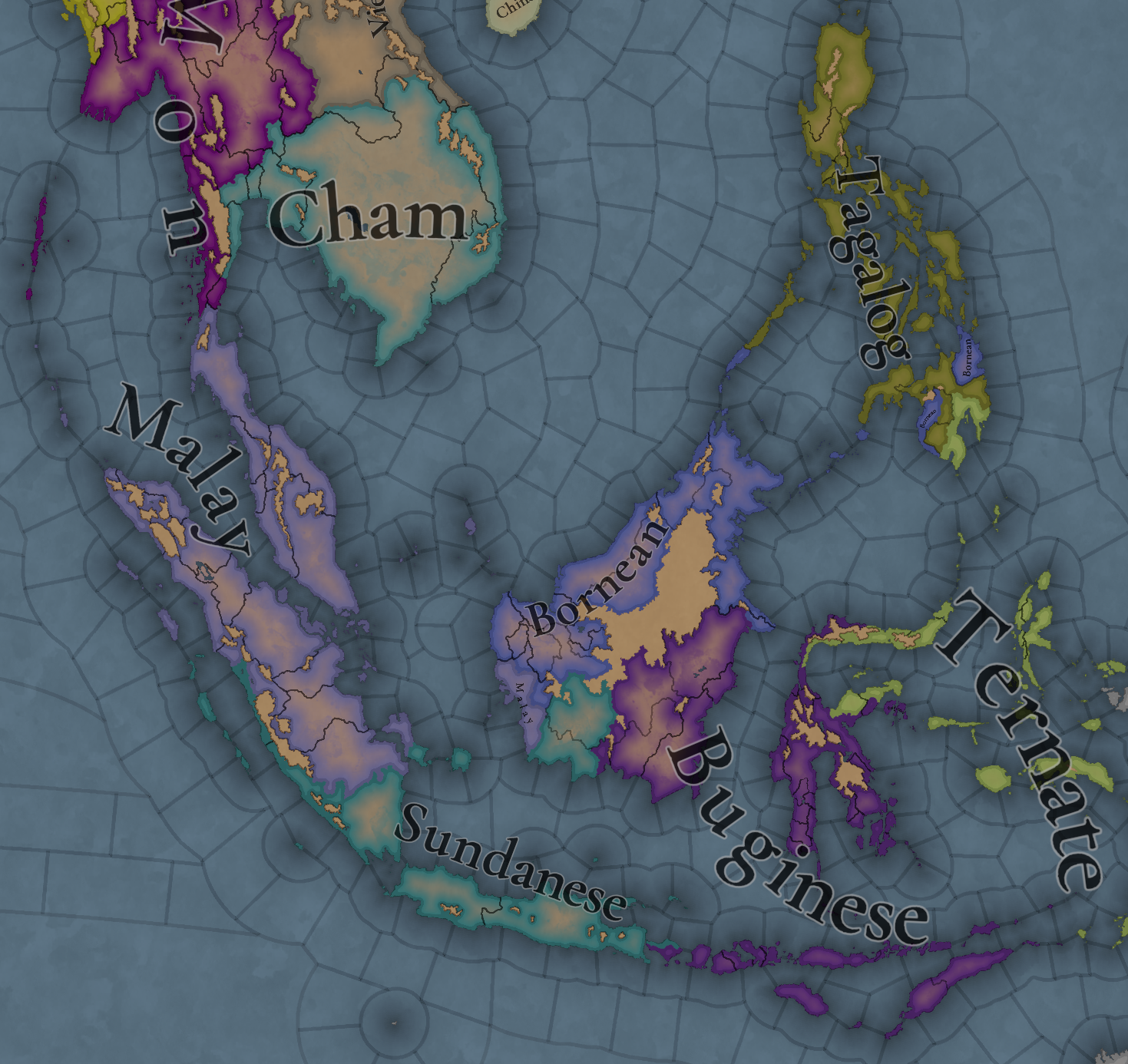
With that said, let's focus on Indonesia again. This region is also one of the most varied religion-wise. It is notable the presence of Hinduism and Mahayana, as the prominent countries in this area were Hindu-Buddhists before the arrival of Islam, which is currently just starting to make its entrance through the north of Sumatra.


Languages
Languages.png

One thing I want to say here regarding languages (as for example I saw someone getting surprised by the Mon language presence in the south of the Malay peninsula) is that we have had to make some grouping of languages in certain cases. Among many other issues, languages need to have sets of names for characters, so in cases that we couldn’t find a suitable big enough group of names for a language, we were forced to group it with another one close in their linguistic group (even if just temporarily). We are currently working on improving this, so that we can have the best possible representation without having to compromise gameplay, so it is quite possible that some of the languages that we have been forced to group into bigger groups get further splits in the future. Also, dialects were not a thing yet when we did this area, so nothing about that is implemented here yet.

Court Languages
Court Language.png

Not much difference with the normal languages map, except only in those cases where a country is ruling over another culture (which will be mitigated once minorities are done)

Raw Materials
Raw Materials.png

Raw Materials zoom 1.png
Raw Materials zoom 2.png
Raw Materials zoom 3.png
Raw Materials zoom 4.png
Mainly lumber due to so many jungle, but also some other interesting resources here. And obviously also quite a bit of spices in the Spice Islands.

Markets
Markets.png

Market Languages.png
Added here also the market languages, although keep in mind that it is just the language of the culture of the market center.

Population
Population.png

Population zoom 1.png
Population zoom 2.png
Population zoom 3.png
Population zoom 4.png
Population zoom 5.png
Population zoom 6.png
Population zoom 7.png
Population zoom 9.png
Population zoom 10.png
Majapahit is the most populated, which will help them become the regional hegemon they historically were.

That is all for this week. Don’t put away your boats yet though, as next week we will continue our seafaring adventures and take a look at Oceania. See you there.
 
  • 125Like
  • 44Love
  • 5
  • 3
Reactions:
For Java's resources map I see there is no coffee nor sugar. Coffee was only introduced around 1700 by the VOC, but sugar(cane) far earlier by Chinese people around ~1400 (in the lowlands of north-west Java). Can resources like these appear/be introduced?

Maybe some locations in Indonesia should already have some limited sugar production from palm sugar.

The VOC (Dutch India Company) changed strategy in the 18th century specifically because of these cash crops. At first they only held a few trading posts/fortresses and only small plantations for spices, but in the 18th century prices for spices dropped, so they switched to producing and selling cash crops which required a lot more land, which kickstarted the conquest of Java.

It would also be nice if an independent Java/Indonesia can acquire these for alt-histories.
 
  • 7Like
Reactions:
Topographical Analysis

Overview and summary
  • Sumatra needs a dramatical increase in wetlands
  • Overall some minor readjustments regarding hills-mountains-flatlands
  • Some smaller, but locally important mountain ranges are currently not present in S-Phillipines and S-Borneo

Topography - Current Tinto DesignTopography - Suggested DesignTopography - Suggestions 'changelog'
Topo_TintoCurrent.png
Topo_Suggested.png
Topo_Changelog.png


Non-wetland Topography

Terrain Ruggedness IndexDEM - exaggerated lower topographyDEM - linear color scale
DEM_TRI.png
DEM_Colorful.png
DEM_Viridis.png

Wetlands

The wetlands in modern Indonesia are heavily damaged by the extensive plantations that have been popping up everywhere since the 1970s. These plantations are riddled with canals and gullies to drain the wetlands, which leads to the once extensive wetland regions of Indonesia to be barely recognisable from sattelite imagery.
Some papers on Indonesia's wetland degradation: Mapping wetlands, Wetland loss over the past 3 centuries. There has been a call from the scientific community to attempt to map Indonesia's peaty wetlands, as this is a very difficult index to map reliably for this region.

Nonetheless, we can infer the most dominant wetlands in the region by comparing several sources:
- CIFOR
- PEAT-ML
- Global Wetlands and Lakes
- Inundation depth of 100year flood events

Delineation of suggested ingame wetland (green) on the CIFOR database mapDelineation of suggested ingame wetland (green) on the Peat abundance map (PEAT-ML)
Delineation of suggested ingame wetland (green) on the Global Wetlands Database
Delineation of suggested ingame wetland (green) on the Flood hazard map.
Wetlands_Cifor.png
Wetlands_PeatML.png
Wetlands_WetlandsDB.png
Wetlands_100yFloods.png

Population

Considering the high population of Java, I feel the development map mode for Java is probably a bit underrated in relation to its neighbors.
Modern population mapPopulation ca. 1300 AD (Hyde 3.3 database)Land usage ca. 1300 AD
(Hyde 3.3 database)
Brighter = less people = intact wilderness
"All or nothing" modern population map (black is 0 pop/km²,
white is >0.1 pop/m²)
Population_Modern.png
Population_Popdens1300.png
Population_Anthromes1300.png
Population_ZeroPop.png

Food crops

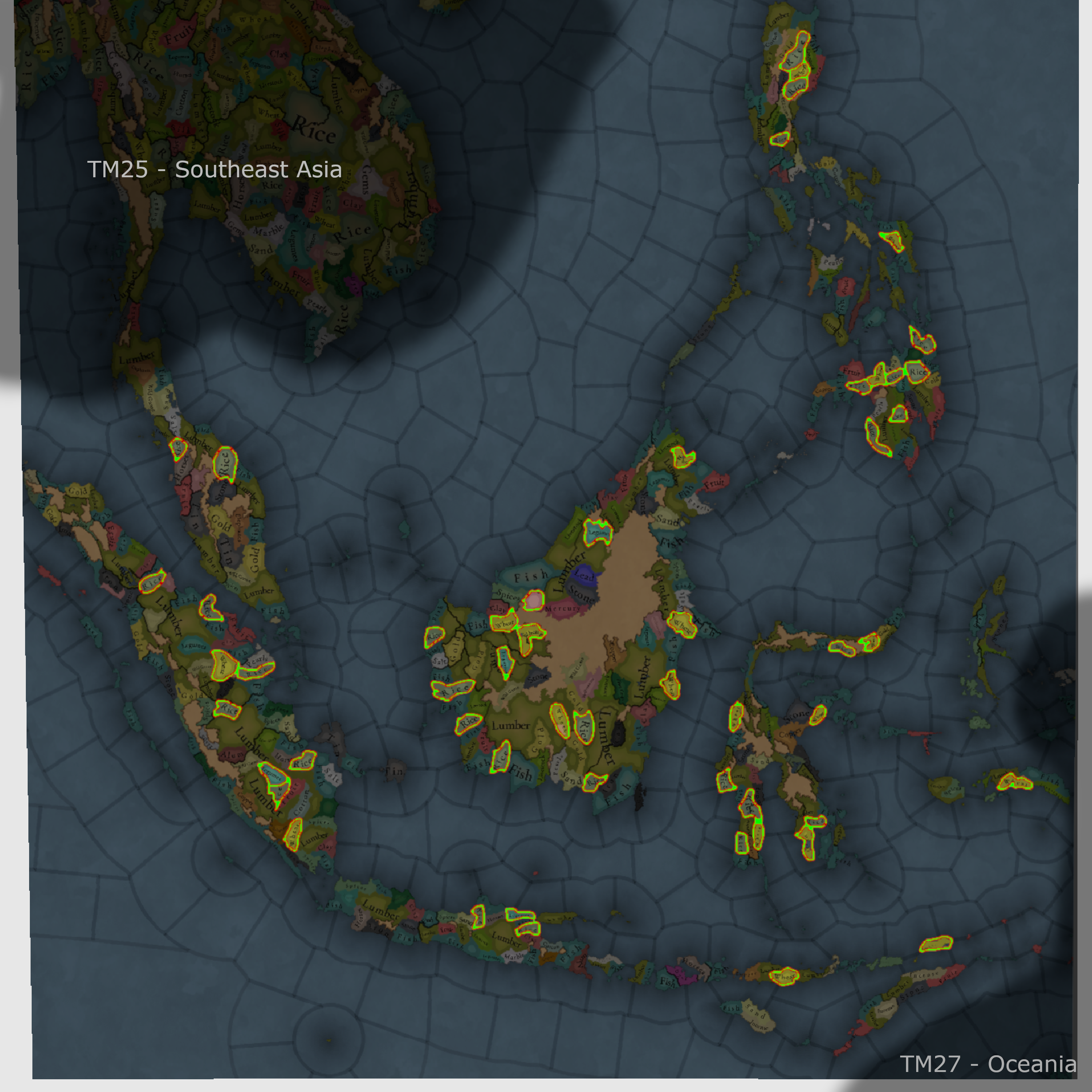
While there are no major offenders, I would just like to indicate that the most fertile regions of Indonesia could use some more crops, while some of the more crop dense regions of the current game design aren't as fertile IRL.
Current food crop distribution (Rice, Wheat, Legumes)Food crops en soil fertility mapRecolored soil fertility map (bright = highly fertile)
Soil_Fertility_materialsFoodCrops.png
Soil_Fertility_FoodCrops.png
Soil_Fertility.png

Vegetation

Extrapolating vegetation patterns from modern times back to historical periods is nigh impossible to perform correctly. Nonetheless, often woodlands have been stripped and repurposed for plantations. These plants also photosynthesize, which are also measurable from sattelites. Therefore, the NDVI (Normalized difference vegetation index) is a great tool to visualise relative vegetation density, where plantations are also still recognisable. Of course, forests that were stripped for herbaceous crops will of course appear as grasslands, relatively speaking.

That said, Java should have less jungle and more forest/woodlands or even grasslands in the historically significant areas.

Tinto's vegetation mapModern vegetation Index map
Vegetation_Tinto.png
Vegetation_NDVI.png
 
  • 30Like
  • 7Love
  • 4
  • 1
Reactions:
For Java's resources map I see there is no coffee nor sugar. Coffee was only introduced around 1700 by the VOC, but sugar(cane) far earlier by Chinese people around ~1400 (in the lowlands of north-west Java). Can resources like these appear/be introduced?

Maybe some locations in Indonesia should already have some limited sugar production from palm sugar.

The VOC (Dutch India Company) changed strategy in the 18th century specifically because of these cash crops. At first they only held a few trading posts/fortresses and only small plantations for spices, but in the 18th century prices for spices dropped, so they switched to producing and selling cash crops which required a lot more land, which kickstarted the conquest of Java.

It would also be nice if an independent Java/Indonesia can acquire these for alt-histories.
I think in an ideal world there should be a way to change grown resources if you have a location under your control which has a certain crop or spice and the location you're 'planting' it in has the correct climate. For example there are several locations in East Africa (Zanzibar, to name the most famous) which are also as important as they are during this time period because of introduced spices, some from India, Indonesia and America (Piri Piri in Portuguese colonies)

Balancing a dynamic system like this which could absolutely cause strange economic behavior or make the player rich beyond what should be possible sounds incredibly difficult, though, so I'd understand why it would take too much work for something like that. I guess it could be managed with something similar to a smaller 'Columbian exchange' but for goods cross-pollinating in the Indian Ocean region.
 
Last edited:
  • 5Like
Reactions:
For Java's resources map I see there is no coffee nor sugar. Coffee was only introduced around 1700 by the VOC, but sugar(cane) far earlier by Chinese people around ~1400 (in the lowlands of north-west Java). Can resources like these appear/be introduced?

Maybe some locations in Indonesia should already have some limited sugar production from palm sugar.

Agreed, there should definitely be sugar in West Java.
Chinese travelers to Malaya in the 13th and 14th centuries talked about how the locals would drink fermented sugar cane, so I don't see why sugar production wouldn't be in other parts of SEA as well.
And we know that Chinese sugar production and trade was important in Banten.
When over 10000 Chinese were killed in the 1740 Chinezenmoord massacre, it took 20 years of government spending for sugar production to recover to the level it had before.
 
  • 3Like
Reactions:
I'm surprised the orang asli are an SoP. I didn't think they ever had a unified identity, or ever formed a coalition to fight other groups.
You'd kind of expect them to have an endonym if they had, rather than just using the Malay word for aborigines.

I find it a bit strange as well. I'm neither an expert on the criteria for making peoples an SoP, nor on the Orang Asli, but from what I've seen in my research on Malaya, it seemed that they either lived with settled society on the coast or dispersed in several different tribes on the interior.
It looks to me as if the former group was fully integrated, while the latter group was very secluded. I saw nothing of political struggles between the Orang Asli and the Malay Kingdoms. After all, settled land wasn't really expanded into the interior until the 19th century.
 
I pulled an all-nighter to write this masterpiece and honestly I don't even know what I'm typing but if you want to waste your precious time, here you go. Be warned that there are no images in this post

Corrections & questions:
  1. Banda Islands were the only source nutmeg and mace before 19th century, but I don't see it on the map. It consists of 11 islands (7 inhabited). So I think it's crucial to add these locations in the game because in 1602-1621 the Dutch brought Japanese mercenaries and did a little bit of massacre and slavery there, killing off local people including their oligarchy called Orang Kaya (Rich People/Rich Men)​
  2. It's not visible if Bawean is considered it's own location or not. If not, then it should be. The people is called Bawean, The Madurese call them Ḅâbean, Ḅâbian, or Ḅâbinian, and the English call them Boyan. Later the Bawean themselves adopted the English name for them so they call themselves Boyan. They are closely related to the Javanese and Madurese. In the late game they will migrate to Malacca and other places in British Malaya either in 1819 and 1849. They also will migrate to Australia in 1887 and Vietnam in 1885 and become minorities that assimilate to the local people there. Obviously Project Caesar won't cover the late 1800s, but that's just a bonus TMI​
  3. Gresik should have that piece of coastal land that is currently the eastern and northeastern coast part of Tuban. Maybe you can follow the present-day Kabupaten Gresik border, though I don't know if the current border is the same as it was back then. Any locals who have grandparents who lived in 1337 and still alive now? Please ask them to review the map​
  4. Enggano: "Enggano" is the Portuguese name for the island, which means "Mistake". The local called it "È Loppeh" (soil/land/earth), the Malays called it "Pulau Telanjang" (Pulau: Island, Telanjang: Naked). Several tribes inhabit the island: Kauno, Kaahoao, Kaharuba, Kaitaro, Kaaruhi, and Kaamay. I don't think you should split that small island into 6 locations, but perhaps the name should change between Enggano, È Loppeh, and Pulau Telanjang depends on who owns it. I also hope that they could be made into Society of Pops.​
  5. I don't see Sangiang Island (Sundanese: Sanghyang) on the map. Is it deliberately omitted since it's never been successfully populated despite being bigger than those islands that are part of Krakatau?​
  6. At first I thought why isn't there Makassar location on the map because it's mentioned in Negarakretagama during Hayam Wuruk's reign in 14th century that Makassar was under Majapahit's dominance. But it turns out the sources I read (Wikipedia lol) said the 9th King of Gowa, Tumaparisi Kallona (1510-1546) was the dude who really developed Makassar as a city. Would Makassar be added as a location, split off from Gowa location during this dude's reign?​
  7. Will there be a more historically accurate contact between Macassan contact (which were actually consisted of different ethnic groups such as Makassarese, Buginese, Javanese, etc) with Aboriginal Australians in Arnhem Land? In EU4 it's often impossible to do trepanging ethically without annexing/having a war with Tiwi/Yolngu which makes me feel bad, because IRL the conflict was minimal and most of the trade were mostly beneficial to each other (the Macassan got permit to catch and process trepangs, the Aboriginal Australians got metal (and smallpox, my bad)​
  8. How many locations are there in the Selayar Islands? They're not clearly visible on the map​
  9. The island of Java and Muria was separated by Muria Strait, trading cities around it flourished (Demak, Jepara, Pati, Juwana) and Jong ships were built there. This lasted until around 1657 when river deposits made it shallower. See event suggestions No. 2 below for more feedback​
  10. The locals of Flores island call it Nusa Nipa (Nusa: Island, Nipa: Dragon/snake), so it should be called that before the Portuguese arrives​
  11. The current system of market languange seem to fit more for continental countries as it seems like it spreads equally to all directions. But IRL the market languange across Indonesia should be Malay. It spread to all trading ports across Indonesia, Sri Lanka, and some parts of Philippines (but not all the way inland) and creoles and pidgins were formed in coastal cities. (source: https://en.wikipedia.org/wiki/Malay_trade_and_creole_languages)​
  12. Something is off with that Sunda-Majapahit border. Aren't Purwalingga should be owned by Sunda although with heavy mixing between Sundanese and Javanese people in Tegal and Purwalingga, and later on becomes part of Majapahit/Mataram?​
  13. Will Sama-Bajau people engage in slave trade, coastal raids, and piracy across the archipelago?​
  14. Will Orang Laut be loyal to the Malacca and Johor, aiding them and be given titles and gifts in return?​
  15. Will Moken people live like sea nomads, like the previous two ethnicities mentioned, but mostly doing their own things?​

Event suggestions:
  1. In 1582, Bone, Wajo, and Soppeng formed the Tellumpoccoe Alliance to defend themselves from Gowa-Tallo expansions. Bone became the older sibling, Wajo middle sibling, and Soppeng the younger sibling (ranked based on the land size they own) and they agreed to only expand to areas outside those three alliance members' lands, so perhaps add more locations to this area? (source: https://id.wikipedia.org/wiki/Persekutuan_Tellumpoccoe)​
  2. By 1657: River deposits made Muria Strait shallower and disappear, merging Muria Island into Java Island. Trading center moved to Jepara​
  3. 1890: Dutch East Indies authority built a 12-km canal to redirect Solo River course to Java Sea to prevent the flowing sediment to merge Java with Madura. If the tag that owns Gresik has the required technology and ducats, it should be able to build it even before that year. I'm not sure since when the sediment started causing problems. Someone else please add more info about this. Anyways, today the delta is made into shrimp and milkfish farms/embankments. Gresik already has fish as their trade goods, so no changes are needed for the trade goods, though perhaps could there be bonus fish production for Gresik after the canal has been built and the sediment gradually accumulated at the new riverbank?​

New cities founded and infrastructures built at these dates, perhaps via events, development requirements, etc:
  1. Probolinggo - "Settled" in 4 September 1359 and was called Banger. In 1770, Regent Djojonegoro changed the city's name to Probolinggo, which is also quite a banger name actually​
  2. Makassar - Around 1510-1546, During Tumaparisi Kallona's reign (see Corrections No. 6 above)​
  3. Pemalang - 24 January 1575, Pemalang's existence in the 16th century can be attributed to van Goens Rijkloff records and data in the book of W. Fruin Mees stated that in 1575 Pemalang is one of 14 independent regions in Java, led by a prince or a king​
  4. Samarinda - Officially 21 January 1668, but there are other versions that tells different stories and dates​
  5. Pasuruan - Officially 08 Februari 1686, though it was already an ancient port​
  6. Bandung - The city was founded in 25 September 1810, under Herman Willem Daendels. Although before then, during the 17th and 18th centuries, the Dutch East Indies company (VOC) established a small plantation area in the fertile and prosperous Bandung area. A supply road connecting Batavia, Bogor, Cianjur, Bandung, Sumedang and Cirebon was built in 1786​
  7. That brings us to The Great Post Road/La Grande Route/De Grote Postweg/Jalan Raya Pos. It's a road that was built by Herman Willem Daendels as instructed by Louis Bonaparte to make military supply easier as Netherlands was at war with England. Obviously Daendels didn't built the road by himself. He used Javanese unpaid laborers to build the road. 12.000 perished.​
There are actually more cities that I think should have their own locations as game time progresses, but I'm too tired to add more

Natural disaster events, I will only list a few examples and only the ones that happened during the game date range and a bit more past that end date:
  1. Krakatau/Krakatoa eruptions: 1530, 1680, 1883. I wish the game could be extended so it will end in 1883 with a bang.​
  2. Tambora eruption: 1815. It wiped off the Tambora Culture, caused epidemic and destruction in nearby islands, and the Year Without A Summer worldwide.​
  3. Merapi eruptions: 1786, 1822, 1872​
  4. Marapi eruption (this one is in Sumatra): 1830​
  5. Kelud eruption: 1586, 10.000 people died​
  6. 1797 Sumatra Earthquake, a tsunami hit Padang​
  7. 1833 Sumatra Earthquake, tsunami along the southewest coast of Sumatra​
  8. 1629 Banda Sea Earthquake​
  9. 1699 Java Earthquake​
Personally I think all natural disasters either small or big need to be added to the game at the exact same time and place as in real life because it happened without human touch anyway. Not just in this area but also worldwide, so it could be more realistic than EU4. However, if it's impossible to add every single natural disaster that has happened due to balance or other gameplay issues, I understand it

Other natural phenomenon events:
  1. River course changes: Mississippi https://en.wikipedia.org/wiki/Mississippi_River#Course_changes, Solo river (see event suggestion No. 3 above)​
  2. Formation of oxbow lakes​
This is probably too much and might fall into scope creep, so again I understand if these won't be added to the game. But I hope someday there will be DLC, Expansions, or Mods that allow these to happen in-game for historical accuracy

Tech and Trade goods change question:
  1. Is it possible for a tag to steal a certain trade good and propagate it elsewhere with varying success like how Europeans stole Silk from China?
  2. Is it possible for a Majapahit king to steal cows from the Dutch and cocoa from the Aztecs or Mayans (no offense), bring them back home, then change two of my location's trade goods with livestock and cocoa because I really really like choccy milk?​
Sources of these are mostly from Indonesian and English Wikipedia, can't link them all because it thinks I'm spamming. No, I'm just yapping. I even stole some paragraphs from those pages! I also don't read those books I mentioned because warriors do not read books
 
Last edited:
  • 12Like
  • 2Love
Reactions:
For Java's resources map I see there is no coffee nor sugar. Coffee was only introduced around 1700 by the VOC, but sugar(cane) far earlier by Chinese people around ~1400 (in the lowlands of north-west Java). Can resources like these appear/be introduced?

Maybe some locations in Indonesia should already have some limited sugar production from palm sugar.

The VOC (Dutch India Company) changed strategy in the 18th century specifically because of these cash crops. At first they only held a few trading posts/fortresses and only small plantations for spices, but in the 18th century prices for spices dropped, so they switched to producing and selling cash crops which required a lot more land, which kickstarted the conquest of Java.

It would also be nice if an independent Java/Indonesia can acquire these for alt-histories.
This is modeled by building that can produce the RGOS. There is already a confirmed sugar plantation building that requires slaves. Im hoping there a similar building that doesnt require slaves.
 
Hi @Roger Corominas I'm putting here my comments in the last Tinto Talks on language and culture based on what I could peep on the Philippines. I hope the dev team could take these into consideration:

Tagalog & Ilokano - Luzon
There are some notably distinct groups in the Philippines that were lumped under Tagalog and Ilokano. Save for the Pangasinan who got swallowed by Ilokano, there are the Kapampangan whose approximate location got split between Ilokano and Tagalog. They were historically influential to the Tagalogs of Tondo and Maynila, and whose elites might have intermarried. It even could be assumed that the Tagalogs were a Kapampanganized Central Philippine group (cf. Bikol, Visayan) given the many linguistic features they borrowed from northern groups.

Both Pangasinan and Kapampangan might however cover very few locations, so balancing could be a problem?
1730916588087.png


Barito around Sulu and the northwestern tip of Borneo covers few locations. Much even so for Ternate, Gorontalo, and Halmahera(n).
1730919612831.png

Maybe we can apply the same logic for both Pangasinan and Kapampangan? They after all have had a notable historical presence, especially with Pangasinans' direct interaction with Ming and Japanese pirates.

If balancing is a concern, we may stick with Ilokano and Tagalog. The Pangasinan area can stay Ilokano, while Tagalog (representing Kapampangan) should spread all the way to the westernmost shores of central Luzon to also cover the minority Sambal languages which are closest to Kapampangan and to the easternmost shores. Ilokano's spread is exaggerated:
1730926025511.png


Speaking of which, the Bikol group also got swallowed by Tagalog. Tagalog did not reach as far as the southernmost tip of Luzon during this period. The island in green (Masbate) is in a contact zone between Bikol and Visayan languages, so it's more factual to tag them as Visayan if Bikol cannot be added.
1730916700558.png


Mindoro & Palawan
Mindoro is also surprisingly Ilokano.
1730919845879.png


It was originally inhabited by minority groups today generally called Mangyan, whose languages do not all fall under the same group. Some speak languages closer to Tagalog (and Bikol and Visayan), while some are hypothesized to be genetically closer to Kapampangan (which could be due to migrations far deeper in time and is immaterial to the game's timeline). The island however is definitely within the Tagalog sphere due to huge Tagalog migrations from Luzon. Since we don't have clear historical data when the Tagalogs started to dominate the island or how rapid it was or how frequent the migration patterns were, it still seems more factual to tag Mindoro as Tagalog.

There is much less historical info on Palawan, but it is known to be within the political sphere of Sulu or at least the lower half, while the upper half could be tagged as Visayan. Or you can just either tag the whole island as Tausug/Barito (?) or Visayan.

Mindanao?
The areas where EU4 Lanao and Maguindanao appear can stay lumped under one language, but better to be renamed as Danao.
1730919665960.png


Their dominant populations spoke Meranao and Maguindanao, respectively, which are very closely related. Mindanao might be a misnomer as it was adopted by the Spaniards in reference to the Sultanate of Maguindanao exclusively, but was later used to refer to the entire island. Other indigenous groups in the island not within the range of the language also fall under the "Mindanao" umbrella for cultural and geopolitical convenience.

Perhaps, Danao, the modern linguistic name for their subgroup, could be more fitting. It means "lake" while both "Meranao" and "Maguindanao" stem from the word danaw in reference to them being "people of the lake (Ranao/Lanao)."

Linguistically Mindanao is a group including the Danao subgroup and other subgroups (e.g., Subanen) spoken in various pockets of Zamboanga peninsula which is broadly tagged as Visayan. However, around 1300-1400s Visayans should have already colonized coastal areas of the peninsula, so this may not be entirely wrong. But I don't know :shrug: ‍There could be more nuance to this area between Visayan and (Min)danao.
1730926921370.png


Lastly, the island of Jolo and nearby islands are tagged Visayan when this was a political center of the Sultanate of Sulu and in fact where Tausug is mostly spoken. Unless this refers to Tausug which is indeed genetically Visayan, while the other olive locations speak Sama-Bajau hence Barito? Note that its designation under Barito is still not widely accepted among linguists, but that's a different issue altogether.
1730921057312.png


Market Language
The trading language in the archipelago during this period should be a mix of vernaculars (in-group trade) and Malay (foreign trade). Is there a way to reflect this?
1730927569306.png


If the game's concept of lingua franca requires only one language, can the locations instead be changed to Malay? Parallel to the common language map, Tagalog was not the universal trading language of other non-Tagalog groups. Or there could be a mechanic where the influence of an economically dominant country could shift its market language to its common language (and also influence that of subjects/nearby countries) based on its Language Power + Merchant Power + Market Attraction?
 
Last edited:
  • 13Like
Reactions:
Devs, I have a question. As a Bruneian, I have to ask, why does Brunei not have a good harbour/port? Brunei Bay is controlled by Brunei, and its the main place where Brunei became a thalassocracy
 
  • 1
Reactions:
Sometimes we have to unfortunately use anachronistic geographical terms due to the lack of better options, but if you have any suggestion for a pre-colonial name for the whole Philippines feel free to make suggestions.
I think geographical terms should be used for nowaday players to know where they're currently in, or I 'll suggest using Sükhbaatar instead of Stanovoy in East Siberia.
 
  • 1
Reactions:
No Banda island province or provinces (producing spice of course)? It looks like just open sea south of Seram.

Their claim to fame was the production of Nutmeg and Mace. Both spices were quite important and highly lucrative for the Portuguese and the Dutch. It seems a pity to remove all the islands that historically produced it (I assume due to their small size at just 172 km2).

If you want a taste of their importance - https://en.wikipedia.org/wiki/Nutmeg#Colonial_era or https://en.wikipedia.org/wiki/Dutch_conquest_of_the_Banda_Islands are places to start
 
  • 6
  • 1Like
  • 1
Reactions:
Suggestions on the Philippines:

Hello, here is my suggestion to change the map of the Philippines. Most of the information I am presenting can be found on well-sourced wikipedia articles about historical Filipino polities.

The main issue is that Tondo is way, way too large. This is a modern misconception that originated in the last few decades and has spread to a lot of maps on the internet. In reality it was really not much more than a city-state, similar in size to Maynila, Kainta, and Namayan. In fact, sometime in the vicinity of the late 15th century, Tondo was a vassal within the confederacy headed by Namayan, which would baffle anyone whose understanding is based on this map where Tondo is a massive empire and Namayan doesn't exist.

The only locations I am suggesting are Namayan, since it was probably quite influential during the 14th and 15th centuries. As well as Lubang.

In general, a lot of states are too large, other examples including Ma-i and Sanmalan.

I would also suggest maybe adding the Warays as an unlanded tag, who were fearsome pirates who possibly were responsible for raiding Fujian during the Song-Jin wars.

"Dapitan" should actually be named Bo-ol.

1731727972593.png


Red are countries, green are landless countries

Locations:
It's very funny to see Datu Piang as a location since it was named after a warlord who died in 1933. It should be renamed to Buayan instead and be the capital of Buayan.
Kuta Watu and Baler didn't exist in 1337 but I'm not sure if there are better names for them.
 
  • 7Like
  • 3
Reactions:
Regional refers to the broad origin of the spice, not its localization. If zanzibar starts producing cloves, it would produce moluccan spices nonetheless. Generally it might be possible to categorize spices in different ways, like "peppers", "sweeteners", "antibacterial" and so on, even though it becomes pedantic and lacks immersion IMHO.
So how do you consider allspice in this situation? Allspice is native to Jamaica (one of only three New World spices with chili peppers and vanilla) but competed with cloves and nutmeg in terms of flavor/use. Should Jamaica produce Moluccan spices in that case?
 
  • 1Like
Reactions:
So how do you consider allspice in this situation? Allspice is native to Jamaica (one of only three New World spices with chili peppers and vanilla) but competed with cloves and nutmeg in terms of flavor/use. Should Jamaica produce Moluccan spices in that case?
In this context yes, it probably should. I am inclined to think that the best option is to choose a bunch of spices as individual raw good and all the others as spices, similarly to fruits/dates. Any kind of grouping and generalization leads to problems and impacts both immersion and gameplay.
 
  • 1
Reactions:
The Ngaju really should be a society of pops, they had (and have) a quite sophisticated political culture with many larger tribes with their own subtribes, and historically have worked together to resist outsiders. Ngaju identity is quite strong and they have sophisticated shared traditions. It's very hard to argue that the Orang Asli, who lack a shared language, had a far less sophisticated tribal structure, and aren't even ethnically united, should be a society of pops where the Ngaju are not.
 
  • 3Like
  • 1
Reactions:
So I'm going to be "that guy" again and will once again mention that area sizes, in this case sea areas specifically, are extremely inconsistent. Why is the entirety of the "Indonesia Coast" sea one area? By contrast, you divided the Persian Gulf into three tiny ones... both of which (just like some areas in Japan and China) violate the rule specified in the Exploration TT, which said that an area should be around 25-75 locations (probably except for very isolated archipelagos or in cases where no other option is possible). The "Indonesia Coast" area is much larger than that, and because of this it also displays over most of the land.

A more reasonable area setup would be dividing it to its smaller seas like the Java Sea, Celebes Sea, Philippine Sea, Banda Sea etc.

geography.gif
 
  • 8
  • 6Like
Reactions:
So I'm going to be "that guy" again and will once again mention that area sizes, in this case sea areas specifically, are extremely inconsistent. Why is the entirety of the "Indonesia Coast" sea one area? By contrast, you divided the Persian Gulf into three tiny ones... both of which (just like some areas in Japan and China) violate the rule specified in the Exploration TT, which said that an area should be around 25-75 locations (probably except for very isolated archipelagos or in cases where no other option is possible). The "Indonesia Coast" area is much larger than that, and because of this it also displays over most of the land.

A more reasonable area setup would be dividing it to its smaller seas like the Java Sea, Celebes Sea, Philippine Sea, Banda Sea etc.

View attachment 1217007
They violate their rules all the time, I guess that they show wip maps and tinto talks are not the main focus of the dev group, leaving to inconsistencies.
 
  • 2
Reactions: