• We have updated our Community Code of Conduct. Please read through the new rules for the forum that are an integral part of Paradox Interactive’s User Agreement.

Tinto Maps #28 - 29th of November 2024 - North America

Hello everybody, and welcome one more Friday to Tinto Maps, the place to be for map lovers! Today we will be looking at North America, which is very handy, as we can deliver some Thanksgiving turkey maps to our friends from the USA (and Canada)!

But before I get started, let me have a word on some (shameless) promotion. You may know that we in Paradox Tinto have also been in charge of Europa Universalis IV in the past few years. Well, I just want to let you know that there’s currently an ongoing sale on the game, with several discounts on diverse packages, of which outstands the hefty Ultimate Bundle, which includes all the DLCs developed and released by Tinto in the past 3 years (Leviathan, Origins, Lions of the North, Domination, King of Kings, and Winds of Change), and a whole bunch of the older ones. I’m saying this as you may want to support the ongoing development of Project Caesar this way! Here you may find more detailed information, and all the relevant links: https://forum.paradoxplaza.com/foru...toria-bundle-up-for-this-autumn-sale.1718042/

And now, let’s move from the Black Friday sales to proper Tinto Maps Friday!

Countries & Societies of Pops:
Countries.png

SoPs.png

SoPs2.png

SoPs3.png

SoPs4.png

SoPs5.png
For today’s Tinto Maps, we thought it would be a good idea to show both the land-owning countries and the SoPs. As I commented last week, we’re trying to follow consistent criteria to categorize countries and societies. This is our current proposal for North America, with Cahokia and some Pueblo people being the only regular countries in 1337, surrounded by numerous SoPs. I’m not bothering to share the Dynasty mapmode, as we don’t have any clue about them, and they’re auto-generated.

However, we have been reading and considering the feedback we received last week, in the Tinto Maps for Oceania, so we want to let you know that this is our current design proposal and that we want to hear from you what are your expectations regarding the countries that you would consider landed in 1337*, and also which countries you’d like to play with in this region, either as landed, or as a SoP.

As you may already know, our commitment is to make Project Caesar a great, fun game with your help, and we greatly appreciate the feedback we receive from you in that regard.

* This is already quite tricky, as most of our information only comes from post-1500s accounts when the native societies were already looking very different from two centuries ago. Eg.: The first reports made by Hernando de Soto about the Coosa Chiefom around 1540 points it out to be organized in a way that we’d consider it a Tribal land-owning tag, as confirmed by archaeology. However, that polity was not organized at that level of complexity in 1337, as there isn’t any contemporary data comparable to that of Cahokia. And some decades after the encounter with de Soto and some other European explorers, the mix of diseases had made the Chiefdom collapse, being more akin to what a SoP would be. This type of complex historical dynamism is what makes it so difficult to make the right call for the situation in 1337, and also for us to develop with our current game systems the proper mechanics that would be needed for SoPs to be fully playable (and not just barely half-baked).


Locations:
Locations.png

Locations2.png

Locations3.png

Locations4.png

Locations5.png

Locations6.png

Locations7.png

Locations8.png

Locations9.png

Locations10.png
Plenty of locations, at the end of the day, are a big sub-continent… You may notice that we’ve tried to use as many native names as possible, although sometimes, we’ve failed to achieve that. Any suggestions regarding equivalences of Native and Post-Colonial will be very much appreciated, as this is a huge task to do properly!

Provinces:
Provinces.png

Provinces2.png

Provinces3.png


Areas:
Areas.png

Areas2.png

Areas… And with them, an interesting question that we’d like you to answer: Which design and style do you prefer, that of the East Coast, more based on the Colonial and Post-Colonial borders? Or the one for the Midwest and the Pacific Coast, more based on geography, and less related to attached to modern states? Just let us know!

Terrain:
Climate.png

Topography.png

Topography2.png

Vegetation.png

Some comments:
  • Most climates are portrayed in NA, from Arctic to Arid.
  • The Rocky Mountains are rocky!
  • Regarding vegetation, we wanted to portray the forest cover in 1337, which is tricky, and that’s why some areas may look too homogeneous. Any suggestions are welcome!

Development:
Development.png

Not a very well-developed region in 1337…

Natural Harbors:
Harbors EC.png

Harbors WC.png

Harbors3.png


Cultures:
Cultures.png

Cultures1.png

Cultures2.png

Cultures3.png

Lots of cultural diversity in NA!

Languages:
Languages.png

And the languages of those cultures!

Religions:
Religions.png

Religions2.png

We have a mixed bag here: On the one hand, Eastern and Northern religions look more like the design we’re aiming to achieve, while on the other, to the south, you can find the splitter animist religions based on cultures that we now want to group into bigger religions, more akin to the northern areas.

Raw Materials:
Raw Materials.png

Raw Materials 2.png

Raw Materials3.png

Wild Game, Fish, and Fur are king in this region! But we are also portraying the ‘three sisters’ (maize, beans, squash), the agricultural base for many of the native American societies, using Maize, Legumes (beans), and Fruit (squash). Cotton is also present in the south, as it was also native to the region (although the modern variant comes from a crossing with the ‘Old World’ one), and there are also mineral resources present here and there.

Markets:
Markets.png

Two markets are present in 1337, one in Cahokia, and another in the Pueblo land.

Population:
Broken map! But as this is an interesting topic to discuss, these are the current numbers we’ve got in the region:
  • Continent:
    • 20.487M in America (continent)
  • Sub-continents:
    • 10.265M in North and Central America (we have a pending task to divide them into two different sub-continents)
    • 10.222M in South America
  • Regions (roughly 1.5M):
    • 162K in Canada
    • 1.135M in the East Coast
    • 142K in Louisiana
    • 154K in the West Coast
    • 43,260 in Alaska

And that’s all for today! There won't be a Tinto Maps next week, as it's a bank holiday in Spain (as I was kindly reminded in a feedback post, you're great, people!), so the next one will be Central America on December 13th. But, before that, we will post the Tinto Maps Feedback review for Russia on Monday, December 9th. Cheers!
 
  • 184Like
  • 49Love
  • 20
  • 7
  • 7
Reactions:
If this is EU5 and a rather eurocentric game then the colonial powers PoV should take priority over what makes sense for natives who wont be around until the end anyways.

Comes down to how much railroading and how much sandboxing there is in the game. In EU4 it's quite possible for a player starting as native to be around at the end, even do a WC.
 
  • 3
  • 1Like
Reactions:
The Area map feels wrong to me. The western areas seem more natural while the areas in the east just follow the state borders of modern times. Personally I would rather it be one or the other.
 
  • 2
  • 1Like
  • 1
Reactions:
At this point I really don't understand the philosophy behind what counts as a "SoP" vs. a "settled country." Under what definition are the Mississippians not "settled"? Under what definition is 1337 Cahokia "settled" but not the other Mississippians with the same political structure? And why would Coosa/Etowah have been less of a settled country towards the height of the Mississippian period than during its decline? I understand that the political model of Mississippian paramount chiefdoms is difficult to model in-game, but I would much sooner have them represented as sedentary and playable countries (thus ignoring the nuance of successive political cycles and relocations) than have them portrayed as stateless societies. The identities of the major Mississippian polities was based out of political unity by a ruler in a permanent capital over a geographical area, not cultural unity.
This is also proving to be an issue in the Great Basin and both sides of the Rockies. I get that the 1337 start date puts it at a bit of an awkward point in time for the region where yeah the Ancestral Pueblo peoples have moved out of places like Mesa Verde and Canyon de Chelly only in the previous century, but the Utes, Paiutes, and Shoshone were already moved into the area by 1300 and there should at least be some Societies of POPs to represent them.

It's mostly just sad that in the western US the developers have kind of ignored a really great opportunity to show a lesser known part of the indigenous history of the area that most people don't see because the European documentation we have came so late in the area's history. In edge cases like these they really should be falling much more on the side of Societies of POPs rather than just empty space than they are currently, especially if they want to represent the changes of the region over the game's time period well.

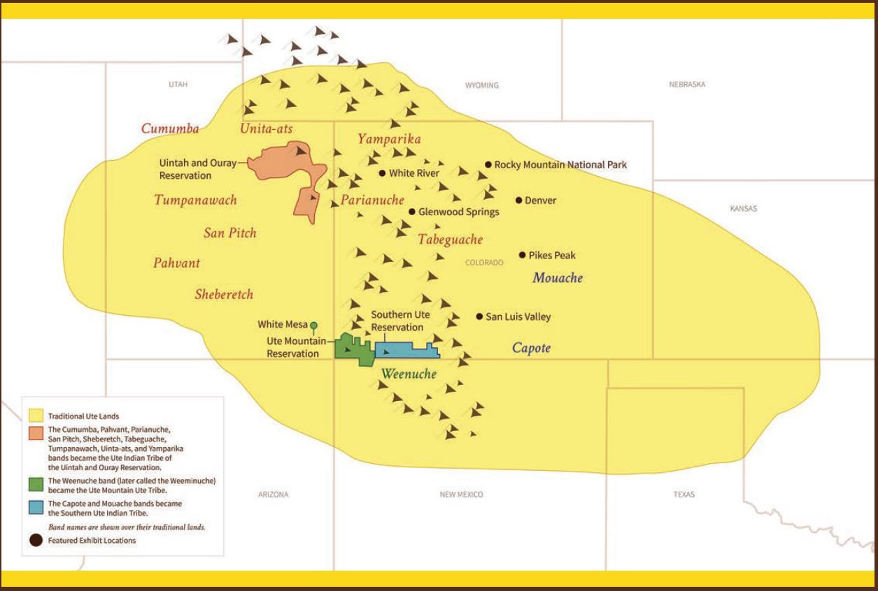
This is a pretty decent map of the range of the Ute and the approximate locations of the different bands during the time period before the Cheyenne-Arapaho migrations into the area.
Traditional-Ute-Tribal-Lands-300-dpi.jpg


Source: https://www.goldenhistory.org/new-o...owledge/traditional-ute-tribal-lands-300-dpi/
 
  • 11Like
  • 1
  • 1
Reactions:
British Columbia was at one point the most densely populated part of Canada and the natives were prolific traders and fishers

I'd guess at two times:
- all the way in the beginning, when humans were on their way to settle the Americas.
- at some point when Europeans still had to start arriving in the east, but diseases had already decimated the native populations in the middle (and not yet fully all the way in the west)

I wouldn't consider either really relevant to the map, am I missing a third period that this was the case?
 
  • 1Like
  • 1
Reactions:
Regarding colonial borders, I think the provinces and areas can approximate them, but the locations should not have such artificial straight lines. Earlier colonial boundaries should take priority over later ones (where is West Florida?), and natural boundaries like rivers and drainage divides should take priority over linear ones.

If nothing else, I would recommend following the Eastern Continental Divide up to the level of Province, maybe even Area, since it is a clear natural boundary and otherwise there would be no in-game way to represent the Royal Proclamation Line.
 
  • 5Like
Reactions:
Hey devs!
Long time lurker, first time poster.
In advance, thank you for all the hard work! Keep it up!

I’ve got some insightful information to share.
I’m from St. John’s, Newfoundland and we’re accustomed to being overlooked even as Great Britain’s oldest colony.
However; the importance of this place is tied to the early exploration of many European nations.

St. John’s should 100% be a natural harbour.
The natural geological features of the harbour have long been known by Europeans as a defensive safe haven dating back to the early 1500’s, and was used by the Basque, French, Portuguese and Spanish for nearly a century prior to the permanent settlement of North America. It was mostly used as a fishing station during the migratory fishery.

“It is likely, although uncertain, that the name "St. John's" was given to the harbour by Basque or Portuguese fishermen in the early 1500s, as it is labeled "Säo Joäo" (St. John's) on a Portuguese map from 1519.”

It’s here on 3 August 1527 that the first known letter was sent from North America. While in St. John’s, John Rut had written a letter to King Henry VIII on his findings and his planned voyage.

One more thing to note.
Placentia is actually located on the Avalon peninsula, so the naming is rather confusing. Important to note since Plasaince (castle hill) was the only fortified French settlement on the entire island, which itself deserves a natural harbour.
The Avalon province should only exist within the boundaries of the Avalon peninsula.
The other peninsula that’s akin to the Italian boot would be the Burin Peninsula. (Another Basque name)
 
Last edited:
  • 6Like
  • 1
Reactions:
Yá’át’ééh!

First of all, thank you for providing this space for players of your games to share their feedback! It is my first time commenting but I have been checking the maps so far and I think that is incredible the amount of detail that is going to be in the game.

However, I'm not very pleased with this one. The cultures and SoPs are looking good with an effort for your part to have the original names, especially in comparison with EU4. I was surprised that the 5 Haudenosaunee nations are SoPs instead of normal countris considering they were previously mentioned (like in the Slavery dev diary). I am aware that you have stated that are open to broadening the definition since the Oceania map feedback and I am very glad and suggest that the Haudenosaunee receive this treatment too!! Their constitution influenced the USA constitution.

I want to focus on the population of the Americas:

It seems that you have implemented the 20 million estimation since it is still use in some academic works today and in popular books like "Guns, Germs and Steel" from Jared Diamond. But by the end of 20th century, the common estimation seems to be closer to 60 million, probably around 50.

I also thought that maybe you want a lower number than 50 since the estimation is supposed to be just before the arrival of Europeans to the Americas and Project Caesar starts roughly 150 years before that point but if that is the case there should be a system were SoPs are able achieve this estimation of their population by that time on their own. Confirmation of a system like that will be greatly appreciated!

I understand that these maps are going to be pretty controversial and the estimation is also a controversial topic. But of all my gripes with this diary, this is the one that I am more interested in discussing.

Thank you for your work and looking forward to seeing more from "Turtle Island" next week and my homeland South America!!

Note: shout out to Rosencreutz for your videos and providing me with the source:

60 million estimation is from "Earth system impacts of the European arrival and Great Dying in the Americas after 1492"

the 50 million estimation I got from Wikipedia but they provide some documents discussing the numbers - Population history of the Indigenous peoples of the Americas
 
  • 13Like
  • 3
  • 1Love
Reactions:
Would it be possisble to A) expand the texas area, and B) shift locations a bit so it's possible to form a country with the texas borders? (Both texas today, and our outragous claims in the north)
 
I think that the Dorset people should have their own language and not speaking cree. It could also be cool if there were some events or something so in the first 200 years inuits would come and replace the dorset, as happened historically. (Propably not topic of this tinto maps, but if there were some content for norse people lose their colonies in Greenland inuits should also replace norse people from there.) I also think that it would be cool if there would be at least some inuit SOPs and Dorset SOP, and maybe one Hudson bay inuit playable nation, if SOPs will not be playable, so we could play the Thule expansion ourselves.


Cool map from wikipedia about how inuits (thule culture) replaced the dorse and the norse.
1732906581646.png
 
Last edited:
  • 14Like
  • 4
Reactions:
Surely there is a better name for the Mississippian religion than "Ceremonial"? I know that it's meant to represent the Southeastern Ceremonial Complex, but so many religions in the world could be described as "Ceremonial". Is it a placeholder name while y'all think of something better?
 
  • 10Like
  • 2
Reactions:
To echo previous posters, the lack of the mountains on the coast of the Pacific Northwest is a major issue - not only are the Pacific Coast Ranges (of which the Cascades are a part) largely missing but other mountain ranges like the Columbia Mountains, the Insular Mountains and the Olympic Mountains are also unrepresented.

I would also echo that the coastal Pacific Northwest First Nations should be SoPs. Pre-contact population estimates vary widely but a couple hundred thousand seems reasonable.

Having fish be the majority trade good on the Pacific Northwest coast seems a bit samey. Sea otter pelts were the first trade good Europeans were interested in when they arrived in the 18th century. There are also some immense trees on the coast so lumber should also be a possibility.

I need to look into it a bit more but I do not think the areas of grassland in what is now northern British Columbia and the Yukon is representative of the pre-contact vegetation. Where you do see a lack of forests is in some of the drier valleys in southern British Columbia - the Fraser Canyon, the Okanagan and the Thompson are the most well known examples. Some parts of these areas are considered semi-arid.

On the topic of sea lanes, sailing to and from the Pacific Northwest to Hawaii was definitely a thing in the period the game covers.

I would favour boarders based on geographic features rather modern political ones.

I will provide more detailed geographic feedback on what is now British Columbia and adjacent areas in future posts. I will say I am happy with the location density in this part of the world.
 
  • 10Like
  • 6
Reactions:
Considering that vegetation can't change throughout the game, I'm going to lobby for some farmlands here.

Since stitching the detailed location maps together seems to be impossible, I'm not going to make a big vegetation map, rather I'll focus on some suggestions drawn onto the provided map.

Mississippi/Mid West:
veg1.png

Grassland for the settled/farmed areas and possibly farmland for population centers around Memphis and St.Louis(/Cahokia).

More woods towards the west. I'm not sure why there is so much grassland there. Wasn't this all woodland?
1732905263587.png


East:
veg2.png

Controversial, but I'm pitching two colonial farmland areas here. This is where most of the population of Canada and the Thirteen Colonies was concentrated.

Canada ended up supplying a lot of grain for England's growing population towards the end of the game's time period. The climate around Lake Ontario and the St. Lawrence might not be perfect, but the soil is very fertile and even today, this is where a large portion of the Canadian population lives.

The indicated area at the US East Coast was was famous for its abundance of good soil which led to it being called the breadbasket of the colonies. The Middle Colonies (Pennsylvania, Delaware, New Jersey, New York) attracted the most immigrants from all over Europe and this stretch of fertile land was densely settled by the end of the time period. This is also where most of the important cities were located.

The indicated farmlands naturally emerged as the best spots for colonial settlement in North America and I think it would be nice if that was reflected in the game, rather than everything just being woods or forest. If farmlands is too much (which is understandable), then grasslands would make sense, too, in my opinion.

California:
veg3.png

Should the Central Valley not naturally be grassland rather than have sparse vegetation? It should definitely be wetland too, as it has an overabundance of water and flooding has always been a big problem.
Of course, the modern Central Valley is extremely productive farmland that lacks water, but before the 19th century, grassland-wetland makes the most sense in my opinion.
 
Last edited:
  • 5
  • 2Like
  • 2
Reactions:
I FINALLY have some expertise on this whole map business! Going north to south on the East Coast, I have a few suggestions for natural ports to add/remove (NOT exhaustive)

-The question mark is Portsmouth (Squamscott), now in New Hampshire, never a big port and not with an amazing harbor, but there is a Naval base there now and was one of the bigger shipbuilding ports on the east coast, up to your discretion
From Wiki: "Strategically located for trade between upstream industries and mercantile interests abroad, the port prospered. Fishing, lumber and shipbuilding were principal businesses of the region.[3] Enslaved Africans were imported as laborers as early as 1645 and were integral to building the city's prosperity.[4] Portsmouth was part of the Triangle Trade, which made significant profits from slavery."

-Next is the X mark on Cape Cod (Nauset), not sure what port that is referring to, but there was never anything major in that location, except maybe Hyannis or possibly Nantucket or Martha's Vineyard, not great harbors there.

-The next green circle over is New Bedford (Assonet), also not a large port, but was an important trade and whaling location in the northeast, now in Massachusetts
Wiki: "The late 18th century was a time of growth for the town. A small whale fishery developed, as well as modest international trade. In the 1760s, between the Seven Years' War and the American Revolution, shipwrights, carpenters, mechanics, and blacksmiths, settled around New Bedford harbor, creating a skilled and comprehensive maritime community."

-Next over is Providence/Newport (Seekong) which ABSOLUTELY needs natural harbor suitability due to the well protected Narragansett Bay and navigable sea right up to the city. These were all very important colonial ports due to their natural favorableness and position on the eastern seaboard.
Wiki: "However, the Rhode Island General Assembly legalized African and Native American slavery throughout the colony in 1703, and Providence merchants' participation in the slave trade helped turn the city into a major port."
Wiki: "Newport was the most important port in colonial Rhode Island, and a public school was established in 1640. The commercial activity that raised Newport to its fame as a rich port began with the immigration of a second wave of Portuguese Jews,"

- Next in a line of 3 (from right to left) on the Connecticut coast are Mystic/New London (Siccunemos), Old Saybrook? (Nehantuck), and New Haven (Quinnipiac). The Mystic, but more New London, ports were both important shipbuilding/fishing ports at the mouths of two different rivers (New London is a deep water port on the Thames lol)
Wiki: "The harbor was considered to be the best deep water harbor on Long Island Sound,[7] and consequently New London became a base of American naval operations during the American Revolutionary War and privateers where it has been said no port took more prizes than New London with between 400–800 being credited to New London privateers including the 1781 taking of supply ship Hannah, the largest prize taken during the war."

The Nehantuck location is marked as a low level of suitability, but even though the Connecticut river drains there, no ports ever developed as it is marshy.

New Haven (Quinnipiac) also deserves a low level suitability harbor. It was never as major at NY or Boston but was one of the biggest ports initially on the northern east coast
Wiki: "Economic disaster struck New Haven in 1646, when the town sent its first fully loaded ship of local goods (the "Great Shippe") back to England. It never reached its destination, and its disappearance hindered New Haven's development as compared to the rising trade powers of Boston and New Amsterdam (modern day New York)" (Alt history?? lol)

-Next down the coast is Philadelphia (Shackamaxon) which here has a low level of suitability, but I think it should be higher even though it is technically more inland. The Delaware River was quite navigable and Philadelphia ended up being one of the most important ports in all of North America.
Wiki: "By the 1750s, Philadelphia surpassed Boston as the largest city and busiest port in British America, and the second-largest city in the entire British Empire after London."

-The next is Savannah (Wimbee?) but I think this has been suggested already.

I don't know as much about the other ports in Canada/Gulf Coast etc. but the other East Coast ports all look good to me. Please suggest more if you all have any ideas and THANK YOU to the devs for being absolute legends during this whole development process.
EC Coast.png
 
  • 6Like
Reactions:
This map along with Oceania show that sop's really should be playable. I understand that there are problems with them right now, but i feel like these areas will be really boring to play if sop's just exist as something to be colonized.
 
  • 4
  • 1Like
  • 1
Reactions:
1732904762081.png

Anticosti Island should be a single location. Notiskuan and Natigostec are just native names for Anticosti. Anticosti was used as a hunting ground by the Innu and Mi'kmaq, but it wasn't settled. Even after coming under French control, most people were employed and the population has remained small even to today.


Isn't Erie location eerily big?
Perhaps it is based on Erie County, Pennsylvania or maybe the Erie tribe in northwest Pennsylvania.


It's a real thing, but misplaced. Not the appropriate name for that area, as it basically just included greater Pittsburgh in the actual state of Pennsylvania.


Just renamed them.
Westsylvania should be renamed to Allegheny. The Allegheny River as well as the mountains would be better for representing western Pennsylvania.


And is there anywhere the full names of the Pueblo tags can be seen?


1732906445309.png


Also, "Maryland and Delaware" is gross as an area name :mad:
/s


Edit: Delaware was part of the Province of Pennsylvania
Penncolony.png
 
Last edited:
  • 11Like
  • 3
Reactions: