• We have updated our Community Code of Conduct. Please read through the new rules for the forum that are an integral part of Paradox Interactive’s User Agreement.

Tinto Maps #28 - 29th of November 2024 - North America

Hello everybody, and welcome one more Friday to Tinto Maps, the place to be for map lovers! Today we will be looking at North America, which is very handy, as we can deliver some Thanksgiving turkey maps to our friends from the USA (and Canada)!

But before I get started, let me have a word on some (shameless) promotion. You may know that we in Paradox Tinto have also been in charge of Europa Universalis IV in the past few years. Well, I just want to let you know that there’s currently an ongoing sale on the game, with several discounts on diverse packages, of which outstands the hefty Ultimate Bundle, which includes all the DLCs developed and released by Tinto in the past 3 years (Leviathan, Origins, Lions of the North, Domination, King of Kings, and Winds of Change), and a whole bunch of the older ones. I’m saying this as you may want to support the ongoing development of Project Caesar this way! Here you may find more detailed information, and all the relevant links: https://forum.paradoxplaza.com/foru...toria-bundle-up-for-this-autumn-sale.1718042/

And now, let’s move from the Black Friday sales to proper Tinto Maps Friday!

Countries & Societies of Pops:
Countries.png

SoPs.png

SoPs2.png

SoPs3.png

SoPs4.png

SoPs5.png
For today’s Tinto Maps, we thought it would be a good idea to show both the land-owning countries and the SoPs. As I commented last week, we’re trying to follow consistent criteria to categorize countries and societies. This is our current proposal for North America, with Cahokia and some Pueblo people being the only regular countries in 1337, surrounded by numerous SoPs. I’m not bothering to share the Dynasty mapmode, as we don’t have any clue about them, and they’re auto-generated.

However, we have been reading and considering the feedback we received last week, in the Tinto Maps for Oceania, so we want to let you know that this is our current design proposal and that we want to hear from you what are your expectations regarding the countries that you would consider landed in 1337*, and also which countries you’d like to play with in this region, either as landed, or as a SoP.

As you may already know, our commitment is to make Project Caesar a great, fun game with your help, and we greatly appreciate the feedback we receive from you in that regard.

* This is already quite tricky, as most of our information only comes from post-1500s accounts when the native societies were already looking very different from two centuries ago. Eg.: The first reports made by Hernando de Soto about the Coosa Chiefom around 1540 points it out to be organized in a way that we’d consider it a Tribal land-owning tag, as confirmed by archaeology. However, that polity was not organized at that level of complexity in 1337, as there isn’t any contemporary data comparable to that of Cahokia. And some decades after the encounter with de Soto and some other European explorers, the mix of diseases had made the Chiefdom collapse, being more akin to what a SoP would be. This type of complex historical dynamism is what makes it so difficult to make the right call for the situation in 1337, and also for us to develop with our current game systems the proper mechanics that would be needed for SoPs to be fully playable (and not just barely half-baked).


Locations:
Locations.png

Locations2.png

Locations3.png

Locations4.png

Locations5.png

Locations6.png

Locations7.png

Locations8.png

Locations9.png

Locations10.png
Plenty of locations, at the end of the day, are a big sub-continent… You may notice that we’ve tried to use as many native names as possible, although sometimes, we’ve failed to achieve that. Any suggestions regarding equivalences of Native and Post-Colonial will be very much appreciated, as this is a huge task to do properly!

Provinces:
Provinces.png

Provinces2.png

Provinces3.png


Areas:
Areas.png

Areas2.png

Areas… And with them, an interesting question that we’d like you to answer: Which design and style do you prefer, that of the East Coast, more based on the Colonial and Post-Colonial borders? Or the one for the Midwest and the Pacific Coast, more based on geography, and less related to attached to modern states? Just let us know!

Terrain:
Climate.png

Topography.png

Topography2.png

Vegetation.png

Some comments:
  • Most climates are portrayed in NA, from Arctic to Arid.
  • The Rocky Mountains are rocky!
  • Regarding vegetation, we wanted to portray the forest cover in 1337, which is tricky, and that’s why some areas may look too homogeneous. Any suggestions are welcome!

Development:
Development.png

Not a very well-developed region in 1337…

Natural Harbors:
Harbors EC.png

Harbors WC.png

Harbors3.png


Cultures:
Cultures.png

Cultures1.png

Cultures2.png

Cultures3.png

Lots of cultural diversity in NA!

Languages:
Languages.png

And the languages of those cultures!

Religions:
Religions.png

Religions2.png

We have a mixed bag here: On the one hand, Eastern and Northern religions look more like the design we’re aiming to achieve, while on the other, to the south, you can find the splitter animist religions based on cultures that we now want to group into bigger religions, more akin to the northern areas.

Raw Materials:
Raw Materials.png

Raw Materials 2.png

Raw Materials3.png

Wild Game, Fish, and Fur are king in this region! But we are also portraying the ‘three sisters’ (maize, beans, squash), the agricultural base for many of the native American societies, using Maize, Legumes (beans), and Fruit (squash). Cotton is also present in the south, as it was also native to the region (although the modern variant comes from a crossing with the ‘Old World’ one), and there are also mineral resources present here and there.

Markets:
Markets.png

Two markets are present in 1337, one in Cahokia, and another in the Pueblo land.

Population:
Broken map! But as this is an interesting topic to discuss, these are the current numbers we’ve got in the region:
  • Continent:
    • 20.487M in America (continent)
  • Sub-continents:
    • 10.265M in North and Central America (we have a pending task to divide them into two different sub-continents)
    • 10.222M in South America
  • Regions (roughly 1.5M):
    • 162K in Canada
    • 1.135M in the East Coast
    • 142K in Louisiana
    • 154K in the West Coast
    • 43,260 in Alaska

And that’s all for today! There won't be a Tinto Maps next week, as it's a bank holiday in Spain (as I was kindly reminded in a feedback post, you're great, people!), so the next one will be Central America on December 13th. But, before that, we will post the Tinto Maps Feedback review for Russia on Monday, December 9th. Cheers!
 
  • 178Like
  • 49Love
  • 20
  • 7
  • 7
Reactions:
  • 3
  • 2Like
Reactions:
Would it be possible to have a system where areas at the start are based on geography, but when colonization starts then you have events in which you decide whether you prefer to change the division to represent the modern day states?
 
  • 3
  • 1Like
Reactions:
Haudenodanoan (or however it's spelled, it's very unclear on the map) would be the actual languages of those in the confederacy, while "Iroquoian" would be the more distantly related languages spoken by those outside the main group.
Maybe "Iroquoian" should be split into "Laurentian" and "other Iroquoian" (other name of course)?
It feels weired to have Wendat and Haudenodanoan sit inbetween two geographicly areas of a generic feeling "Rest Northern Iroqouian" language.
I dont have any proper sources of course but it appears to me the "Iroqouian" language on the map just got applied to all the Northern Iroquoian languages that Wikipedia has under "Unclassified". I mainly suggest splitting off Laurentian on the basis that its geographicly seperated from ther rest.
 
  • 2Like
  • 1
Reactions:
I am no expert, but why is this not copper?

1733358618201.png


As far as I'm aware, the largest source of natural copper in the world is located there. This region once was inhabited by the Old Copper Culture, which made widespread use of copper tools, with where it derives its heritage from. Beyond that, I think maybe a few more copper locations should be warranted near it including a couple to the south along the Brule River and Isle Royale, according to Wikipedia.
 
  • 12Like
  • 5
  • 1Love
  • 1
Reactions:
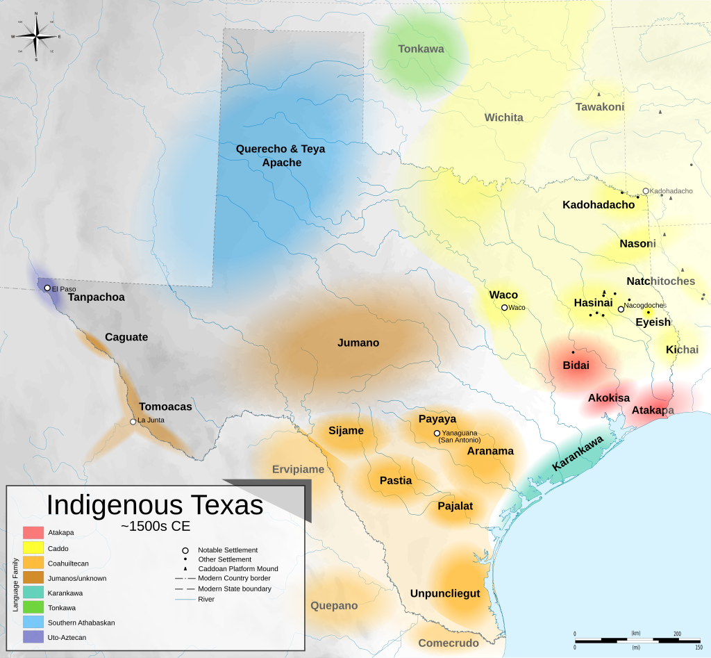
The lumping of what was ~9 different nations into one "coahuiltecan" culture is an oversimplification in my opinion. Here is a map of these tribes c. 1500.


Also, the Calusa should definitely be a settled country. They had a single central ruler, a large system of public works (canals used to facilitate travel between settlements, shell islands, cities, etc), and stratification of their society into commoners and nobles to facilitate the collection of tribute.

Indigenous_Texas_1500.svg.png
 
Last edited:
  • 4Like
  • 2
  • 2
Reactions:
When people say they're anachronistic, they mean for 1337, nobody is claiming Delaware didn't look like that in 1837. Besides that this is kind of just tone policing. It's semantics, we don't disagree.

Again, you're trying to talk for everyone when you can't. You cannot with certainty say "Nobody is claiming STATE X didn't look like that in 1837" because there are people arguing that very point in this thread. Usually, it's in regard to the American midwestern states though, because they're the youngest in the game's time period.

The larger problem is that if you define every post-1337 border as anachronistic, then the majority of the entire map is anachronistic as well. The current map is a mishmash of borders across the game's playable period, presumably ranging all the way from the best understanding of the 1337 borders to the well-mapped borders of 1837. It's a blend of borders spanning 500 years, and it would be inconsistent to consider pre-1837 US borders anachronistic, though I know you said you don't care about consistency.

The Tinto team are seasoned experts in map worship and design. I trust their drawing skills.

I love Paradox's games and respect them as a company, but I do not share your complete faith in them. They're not infallible, and there been some issues and questionable choices on maps in their past games. While I expect them to be even more seasoned now, they're still giving the community an opportunity to provide feedback on the design of what may be their magnum opus, and I'm just sharing my own opinions here.

I'm confused as to why you responded when we agree on everything except you care about consistency (which I acknowledged I'm in the minority here and did not expect anyone to side with me on that). I also never said that I categorically opposed historical borders at all, anywhere, even close. You're allow to have your preferences, that's cool. I like more options than just historical, that's all. That's why I didn't make any arguments based on consistency. I just said what I thought would be best for Northern America, I trust Tinto to figure out what's best for the game. You hate inconsistency, great, have fun. Have a good day.

The reason I responded btw was to point out I think most of us mostly agree and we're all imagining we agree less than we really do. We may prefer this or that , conceptual things (that frankly are entirely up to Tinto's vision for the game) like consistency or just how accurate the borders should be, but for the most part it's a little nitpicky at this point. Sort of talking in circles. Either that or I'm gaslighting myself.

I'm sure we probably do agree on a lot, maybe even 90% of things regarding map design, but that remaining 10% is causing a lot of trouble.
 
Last edited:
  • 1
  • 1
Reactions:
The lumping of what was ~9 different nations into one "coahuiltecan" culture is an oversimplification in my opinion. Here is a map of these tribes c. 1500.


Also, the Calusa should definitely be a settled country. They had a single central ruler, a large system of public works (canals used to facilitate travel between settlements, shell islands, cities, etc), and stratification of their society into commoners and nobles to facilitate the collection of tribute.

View attachment 1226372
Yeah, while the "Coahuiltecan" grouping is used, it's just a broad basket for languages and cultures in this area that are otherwise unclassified. I don't think these groups should be portrayed as having the same culture at minimum. (though I'm not sure how much detail is too much)
 
  • 1
  • 1Like
Reactions:
The lumping of what was ~9 different nations into one "coahuiltecan" culture is an oversimplification in my opinion. Here is a map of these tribes c. 1500.


Also, the Calusa should definitely be a settled country. They had a single central ruler, a large system of public works (canals used to facilitate travel between settlements, shell islands, cities, etc), and stratification of their society into commoners and nobles to facilitate the collection of tribute.

View attachment 1226372
There were far more than 9 tribes in the "Coahuiltecan" region. Most of this 12-page list is Coahuiltecan or otherwise small tribes in South/Central Texas: https://www.tshaonline.org/handbook/browse/categories/tribes-other

If someone can find a suitable way to break Coahuiltecan culture up then that would be great, but that map only shows a few of the more notable groups, it's not even close to being comprehensive. I wouldn't complain if it were divided a similar way, but it's still an oversimplification. There were a lot of small groups in South and Central Texas and for most of them we know very little.

Strongly agreed on the Calusa, though.
 
  • 1
  • 1
  • 1Like
Reactions:
I am no expert, but why is this not copper?

View attachment 1226358

As far as I'm aware, the largest source of natural copper in the world is located there. This region once was inhabited by the Old Copper Culture, which made widespread use of copper tools, with where it derives its heritage from. Beyond that, I think maybe a few more copper locations should be warranted near it including a couple to the south along the Brule River and Isle Royale, according to Wikipedia.
The Upper Peninsula has an insane amount of copper, but it also has an insane amount of iron. It was so much iron that it was pretty much instrumental to the American industrial revolution.

Perhaps it should be split Keweenaw should be copper and Ontonagon should be iron.
 
Last edited:
  • 8Like
  • 3
  • 3
Reactions:
The Upper Peninsula has an insane amount of copper, but it also has an insane amount of iron. It was so much iron was pretty much instrumental to the American industrial revolution.

Perhaps it should be split Keweenaw should be copper and Ontonagon should be iron.

That's an elegant solution. Yes, Keweenaw definitely should be copper, as it was continuously and heavily mined there from Native American times all the way to the present, while iron mining is a much more recent development. Iron in the area would then be represented by Ontonagon.
 
  • 4Like
  • 3
Reactions:
Hello! First time leaving feedback. To start off I would like to say this is a great map. This is the most detail I have seen North America get in a Paradox game and it is especially detailed for this time period. I am making a map for English/American names for locations and some new location suggestions as while I think the density is good I believe the density needs increased for a fun colonial experience.

Continents: I believe North and South America need to be split into two separate continents. Often times Europe is split from Asia is made and if this is the case for Project Ceaser then the Americas should be split as well. I would go with a 6 continents division. Europe, Asia, Africa, Oceania, North America, South America. The other option that I do not prefer is Eurasia, Africa, Oceania. America.

Subcontinents: I believe the subcontinent should be smaller than what they currently are for the Americas. South America: Andes, Amazon, Brazilian Plateau, Patagonia, and Guiana Highlands. North America: Caribbean, Central America, Mesoamerica. California, Great Basin, Rockies, Canadian Shield, Great Plains, Great Lakes, Alaska, East Coast, and Gulf Coast

Areas: Could we have a game rule to use either Geographic or historical borders? This might satisfy both sides. I prefer a hybrid solution, but I know I am in the minority.

I know people are not fans of the strait lines, but I believe the above solution for the subdivisions will satisfy both sides. People who want to recreate the modern borders and those who want a unique experience.

Great Lakes: Lake Ontario and Lake Erie should not connect to each other because of Niagara Falls. I would keep the other four lakes sea tiles but maybe remove Lake Ontario. Maybe others have other thoughts on what to do?

Settled Nations: I believe there should be a few more native nations, but not as many as others are suggesting. I believe Cahokia should not be united but several smaller states. There should be a few sops in California and Cascadia, but I am not 100% on this. Most natives should be sops because they never became true settled nations until the Europeans arrived.

Playability: Do not make sops playable unless there is content for them. I do not think they should be playable if they are not fully fleshed out.

Trade Goods: I think the map needs to be diversified more. Add more stone or marble in Indiana and Kentucky. Not sure which one represents limestone.


Population: I think the population numbers are good. If anything, just adjust them for balance reasons so when the diseases come at least are able to survive.

Ocean: More sea lanes are needed on the west coast and East Coast

Map Issues: The word people for sops seems redundant. The striped lines on the terrain maps are too much. The name placement for markets needs to be less curved so I can read them better. Some of the terrain details are missing from the gulf coast and east coast. More lakes need to be added all over America.

Final thoughts: I really love what guys have done and the level of detail is awesome. I will be working on more detailed reviews to add in the future. If anyone has any thoughts or changes on anything I have said above, please let me know!
 
  • 2Like
  • 2Haha
  • 1
Reactions:
There were far more than 9 tribes in the "Coahuiltecan" region. Most of this 12-page list is Coahuiltecan or otherwise small tribes in South/Central Texas: https://www.tshaonline.org/handbook/browse/categories/tribes-other

If someone can find a suitable way to break Coahuiltecan culture up then that would be great, but that map only shows a few of the more notable groups, it's not even close to being comprehensive. I wouldn't complain if it were divided a similar way, but it's still an oversimplification. There were a lot of small groups in South and Central Texas and for most of them we know very little.

Strongly agreed on the Calusa, though.
I had no idea!!! Thanks for the info
 
  • 1Like
Reactions:
There were definitely a lot of SOPs in the America's but also a lot of proper nations. The idea that there were no nations is only really true if you look at after colonization and the decimation of the Indigenous population across the continent. Although Indigenous peoples could be called 'tribal', they did have councils that ruled, some were even elected, they had laws, trade agreements, etc. In fact trade throughout the Americas is very well documented, where they traded goods, services and ideas and allowed for people to move hundreds of miles. In terms of economy there was no capitalism per se as they were much more focused on the good of the community but that does not mean that parts of it was not developed. There were extensive agricultural fields before the Europeans arrived, in which they grew corn, and other local crops. They domesticated chickens, turkeys and guinea pigs to eat. They had dogs and horses. There was even some honey production I believe in central and south America.

The point being that you don't need a king to be a kingdom, or have palaces. The Huron and Iroquois had no need to migrate as they lived in rich fertile land, with mild winters as they lived around Lake Ontario. Also the Erie, Petun, Neutral and Haudenosaunee. (I cannot speak to the rest of the continent).

Also over a a hundred Indigenous languages are spoken today, let alone in 1337. Some estimates are that there are over a thousand, but so few speakers that the language is essentially extinct.

Now when it comes to populations, the estimates range from 8 million to 112.5 million people in the America's, with the Mexican valley and the Andes being the most populous regions. Personally I do not think 20 million is enough. To say the Europeans did not stack bodies unlike any other time in history when they came to the America's would be an understatement. They killed through violence, disease, forced migration, slavery, the list goes on. The fact that there is such little data about populations is mostly due to the myth that the land was empty and waiting for settlers when in fact the land was well lived in and explored.

Also infrastructure, there is the Incan trail which was a proper road. Permanent settlements in Canada include longhouses, sod houses and plank houses. The lack of any large constructions was more of a cultural and spiritual thing than a development issue.

Also people keep provinces and states pre-colonial. Looks much better, if anything there could be an event in game which the colonizing nation can have western borders that would change the shape of the states to look more like modern ones.
 
  • 2Like
  • 2
Reactions:
Hello! First time leaving feedback. To start off I would like to say this is a great map. This is the most detail I have seen North America get in a Paradox game and it is especially detailed for this time period. I am making a map for English/American names for locations and some new location suggestions as while I think the density is good I believe the density needs increased for a fun colonial experience.

Continents: I believe North and South America need to be split into two separate continents. Often times Europe is split from Asia is made and if this is the case for Project Ceaser then the Americas should be split as well. I would go with a 6 continents division. Europe, Asia, Africa, Oceania, North America, South America. The other option that I do not prefer is Eurasia, Africa, Oceania. America.

Subcontinents: I believe the subcontinent should be smaller than what they currently are for the Americas. South America: Andes, Amazon, Brazilian Plateau, Patagonia, and Guiana Highlands. North America: Caribbean, Central America, Mesoamerica. California, Great Basin, Rockies, Canadian Shield, Great Plains, Great Lakes, Alaska, East Coast, and Gulf Coast

Areas: Could we have a game rule to use either Geographic or historical borders? This might satisfy both sides. I prefer a hybrid solution, but I know I am in the minority.

I know people are not fans of the strait lines, but I believe the above solution for the subdivisions will satisfy both sides. People who want to recreate the modern borders and those who want a unique experience.

Great Lakes: Lake Ontario and Lake Erie should not connect to each other because of Niagara Falls. I would keep the other four lakes sea tiles but maybe remove Lake Ontario. Maybe others have other thoughts on what to do?

Settled Nations: I believe there should be a few more native nations, but not as many as others are suggesting. I believe Cahokia should not be united but several smaller states. There should be a few sops in California and Cascadia, but I am not 100% on this. Most natives should be sops because they never became true settled nations until the Europeans arrived.

Playability: Do not make sops playable unless there is content for them. I do not think they should be playable if they are not fully fleshed out.

Trade Goods: I think the map needs to be diversified more. Add more stone or marble in Indiana and Kentucky. Not sure which one represents limestone.


Population: I think the population numbers are good. If anything, just adjust them for balance reasons so when the diseases come at least are able to survive.

Ocean: More sea lanes are needed on the west coast and East Coast

Map Issues: The word people for sops seems redundant. The striped lines on the terrain maps are too much. The name placement for markets needs to be less curved so I can read them better. Some of the terrain details are missing from the gulf coast and east coast. More lakes need to be added all over America.

Final thoughts: I really love what guys have done and the level of detail is awesome. I will be working on more detailed reviews to add in the future. If anyone has any thoughts or changes on anything I have said above, please let me know!
Some of these suggestions are good or purely based on opinion but others are just incorrect based on modern scholarship. The population is way too low based on modern estimates and there should be as many settled nations and SoPs as other are suggesting as that is what current research on those groups suggests. That fact that there are so few settled Mississippian states and no Hohokam states is a glaring oversight on part of Tinto.
 
Last edited by a moderator:
  • 6
  • 1Like
Reactions:
There were definitely a lot of SOPs in the America's but also a lot of proper nations. The idea that there were no nations is only really true if you look at after colonization and the decimation of the Indigenous population across the continent. Although Indigenous peoples could be called 'tribal', they did have councils that ruled, some were even elected, they had laws, trade agreements, etc. In fact trade throughout the Americas is very well documented, where they traded goods, services and ideas and allowed for people to move hundreds of miles. In terms of economy there was no capitalism per se as they were much more focused on the good of the community but that does not mean that parts of it was not developed. There were extensive agricultural fields before the Europeans arrived, in which they grew corn, and other local crops. They domesticated chickens, turkeys and guinea pigs to eat. They had dogs and horses. There was even some honey production I believe in central and south America.

The point being that you don't need a king to be a kingdom, or have palaces. The Huron and Iroquois had no need to migrate as they lived in rich fertile land, with mild winters as they lived around Lake Ontario. Also the Erie, Petun, Neutral and Haudenosaunee. (I cannot speak to the rest of the continent).

Also over a a hundred Indigenous languages are spoken today, let alone in 1337. Some estimates are that there are over a thousand, but so few speakers that the language is essentially extinct.

Now when it comes to populations, the estimates range from 8 million to 112.5 million people in the America's, with the Mexican valley and the Andes being the most populous regions. Personally I do not think 20 million is enough. To say the Europeans did not stack bodies unlike any other time in history when they came to the America's would be an understatement. They killed through violence, disease, forced migration, slavery, the list goes on. The fact that there is such little data about populations is mostly due to the myth that the land was empty and waiting for settlers when in fact the land was well lived in and explored.

Also infrastructure, there is the Incan trail which was a proper road. Permanent settlements in Canada include longhouses, sod houses and plank houses. The lack of any large constructions was more of a cultural and spiritual thing than a development issue.

Also people keep provinces and states pre-colonial. Looks much better, if anything there could be an event in game which the colonizing nation can have western borders that would change the shape of the states to look more like modern ones.
I think personally it seems to me that political structures like the Haudenosaunee confederacy which enable collective political action but do not really function as centralised governments are the sort of the thing the SOP mechanic exists to represent.
 
  • 2
  • 1
Reactions:
As somebody from Chicago, i'm surprised to see such low location density in Great Lakes region compared to east coast, i'd expect europe level density there. why does Checagou produce sand when i've been taught since primary school it was a WETLAND
 
  • 5
  • 2
  • 1Like
Reactions:
Some of these suggestions are good or purely based on opinion but others are just incorrect based on modern scholarship. The population is way too low based on modern estimates and there should be as many settled nations and SoPs as other are suggesting as that is what current research on those groups suggests. That fact that there are so few settled Mississippian states and no Hohokam states is a glaring oversight on part of Tinto.
Many people have quoted sources on here arguing for very extreme amount of people in the Americas and I would have to disagree with that. I do think the numbers should be increased in areas, but most areas besides some hot spots were very sparsely populated. Places like the Southwest (Arizona and New Mexico), Cahokia area, and a few emerging pockets were the only places north of Mexico with very high populations. I would say leading up to the colonization of America the population was growing rapidly. Just not right at 1337. Most places in North America saw population growth and new emerging settled counties in New England and the Southeast. The only place really in decline were the mound builders. Many of the mound builder settlements were abandoned before the Europeans arrived. I did agree with you on there being more states for the Mississippian cultures. However people are on here arguing that Tinto should loosen there standards on sops and settled countries for more playable nations. I think the map should be more based around history. I agree that many of the sops do become settled countries but after the start date and there should be events for them to become settled. Most of my other suggestions had already been made by others and I wanted to back them up. I want the Americas to get the same amount of effort put into them as the rest of the world, but I believe we need to keep it historical.

Edit: I would like to start adding sources, but it gets flagged as spam right now but I do play on posting about my research later. Most of my knowledge of the Americas comes from school, research, and reading the book 1493. I also suggest the devs look into the book because it covers colonization very well.
 
  • 3
  • 1
Reactions:
Many people have quoted sources on here arguing for very extreme amount of people in the Americas and I would have to disagree with that. I do think the numbers should be increased in areas, but most areas besides some hot spots were very sparsely populated. Places like the Southwest (Arizona and New Mexico), Cahokia area, and a few emerging pockets were the only places north of Mexico with very high populations. I would say leading up to the colonization of America the population was growing rapidly. Just not right at 1337. Most places in North America saw population growth and new emerging settled counties in New England and the Southeast. The only place really in decline were the mound builders. Many of the mound builder settlements were abandoned before the Europeans arrived. I did agree with you on there being more states for the Mississippian cultures. However people are on here arguing that Tinto should loosen there standards on sops and settled countries for more playable nations. I think the map should be more based around history. I agree that many of the sops do become settled countries but after the start date and there should be events for them to become settled. Most of my other suggestions had already been made by others and I wanted to back them up. I want the Americas to get the same amount of effort put into them as the rest of the world, but I believe we need to keep it historical.

Edit: I would like to start adding sources, but it gets flagged as spam right now but I do play on posting about my research later. Most of my knowledge of the Americas comes from school, research, and reading the book 1493. I also suggest the devs look into the book because it covers colonization very well.
I generally agree with population of North America, I was talking about the whole of the Americas not just North America though I do think places such as California should have a higher population. Places such as the Amazon had much higher populations at this time, so while I wouldn’t put the population as high as number at contact which my sources suggest were around 40-50 million, I would say around 35-40 million across both continents would make sense. In terms of settled nations I do think that there also should be some Hohokam states, as the culture was at a high point with cities and large canal networks and many other hallmarks of centralised nations. I’m also having the same problems with sources which is annoying as I have a few pages worth of academic articles on these subjects. Also have you read the book 1491 it’s a companion book to 1493.
 
Last edited by a moderator:
  • 3Like
  • 2
  • 1
Reactions: