• We have updated our Community Code of Conduct. Please read through the new rules for the forum that are an integral part of Paradox Interactive’s User Agreement.

Tinto Maps #29 - 13th of December 2024 - Central America

Hello everybody, and welcome to Tinto Maps, the happy Fridays for map lovers! Today, we will be looking at Central America, which includes the Caribbean. Before we start, I want to introduce you @RaulTrullenque , the only member of our Content Design team who had not yet gone public, and who worked really hard on the maps and content of the Central American and South American regions.

And now let’s get started without further ado!

Countries
Countries1.png

Countries2.png

Countries3.png

Countries4.png

Countries5.png

Countries6.png

Countries7.png

Tenochtitlan.png

Mayan.png
Welcome to the Mesoamerican Thunder Dome! This area is characterized by its numerous Altepetl, more or less comparable to city-states. Most of them are ruled in 1337 by peoples of Nahua origin, something that you may see much more clearly in the culture map. The biggest power in this moment is the Empire of P’urhépecherio, though, founded by the Purepecha people. In any case, you may notice that there’s a lot of detail in this area, including a tiny Nahua settlement recently founded on an island over Lake Texcoco, Tenochtitlan. This is the first time in a PDX GSG that we have the island itself present on the map, although the location covers some more land over the lake coast, to make it playable. Finally, we also have the Mayan polities of the Postclassic Period, of which Cocom, with its capital Màayapáan, was the most important, along with others, such as K’iche’ and its capital Q’umarkaj.

SoPs
SoPs1.png

SoPs2.png

SoPs3.png

SoPs4.png
On the outskirts of the Mesoamerican polities, there are plenty of peoples organized on different ways. To the north, we have the ones that populate the area known as Aridoamerica, which were collectively termed by the Nahua as ‘Chichimeca’. We also have plenty of societies close to the Mayan lands and the Isthmus. And, finally, the Taíno people populate some of the biggest islands in the Caribbean.

Locations
Locations1.png

Locations2.png

Locations3.png

Locations4.png

Locations5.png

Locations6.png

Locations7.png

Locations8.png

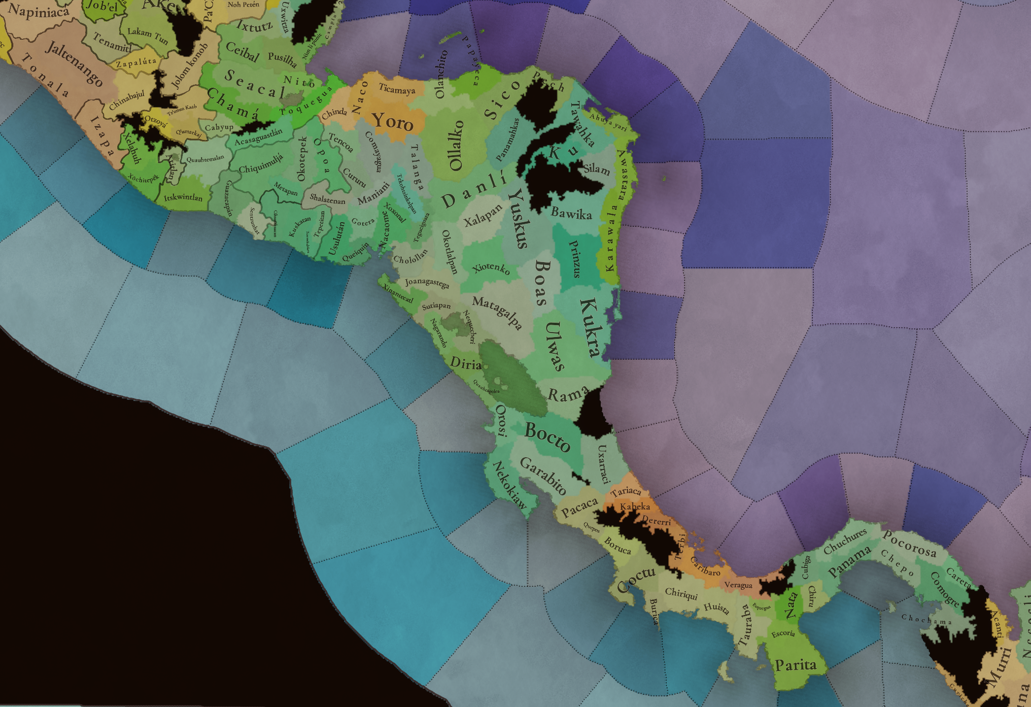
Plenty of locations here! I just want no note that the Darien Gap is an impassable wasteland, which means that any army trying to cross from modern Panama and Colombia will need transport ships to be able to do it.

Provinces
Provinces1.png

Provinces2.png


Areas
Areas1.png

Areas2.png


Terrain
Climate.png

Climate2.png

Topography.png

Vegetation.png

Vegetation2.png

A very diverse region! Most of it is covered by Tropical Jungles and Forests, but Sierra Madre Occidental and Oriental make for very specific conditions in the Mexican Altiplano, which are not only visible in the Topography map but also in the climate and vegetation of the area.

Development
Development2.png

The most developed regions in Mesoamerica are the Valley of Mexico and the Mayan coastline.

Natural Harbors
Harbors.png

There are some good ports in the Caribbean, no surprise that most of them would later become important cities in the Colonial Period.

Culture
Cultures.png

Cultures2.png

Tons of cultures!

Language
Dominant Languages1.png

Dominant Languages2.png

Court Language.png

And also languages! The first two maps are the Dominant Languages per location, while the third is the Court Languages one. The dark blue language is ‘Totozoquean’, as it is not so easily readable (something we have to change).

Religions
Religions.png

This map is today in a more advanced state, as we have merged plenty of cultural religions into regional groupings. Of these, Tonalism, Nahua, and Mayan are part of the Tonalist religious groups, while the others are part of the Folk American group (a regional split of the former ‘Animist’ group). Nahua and Mayan have their different mechanics, which we’ll talk about in future Tinto Talks. Let us know what do you think of this design and any suggestions about the religious grouping!

Raw Materials
Raw Materials1.png

Raw Materials2.png

Raw Materials3.png

Raw Materials4.png

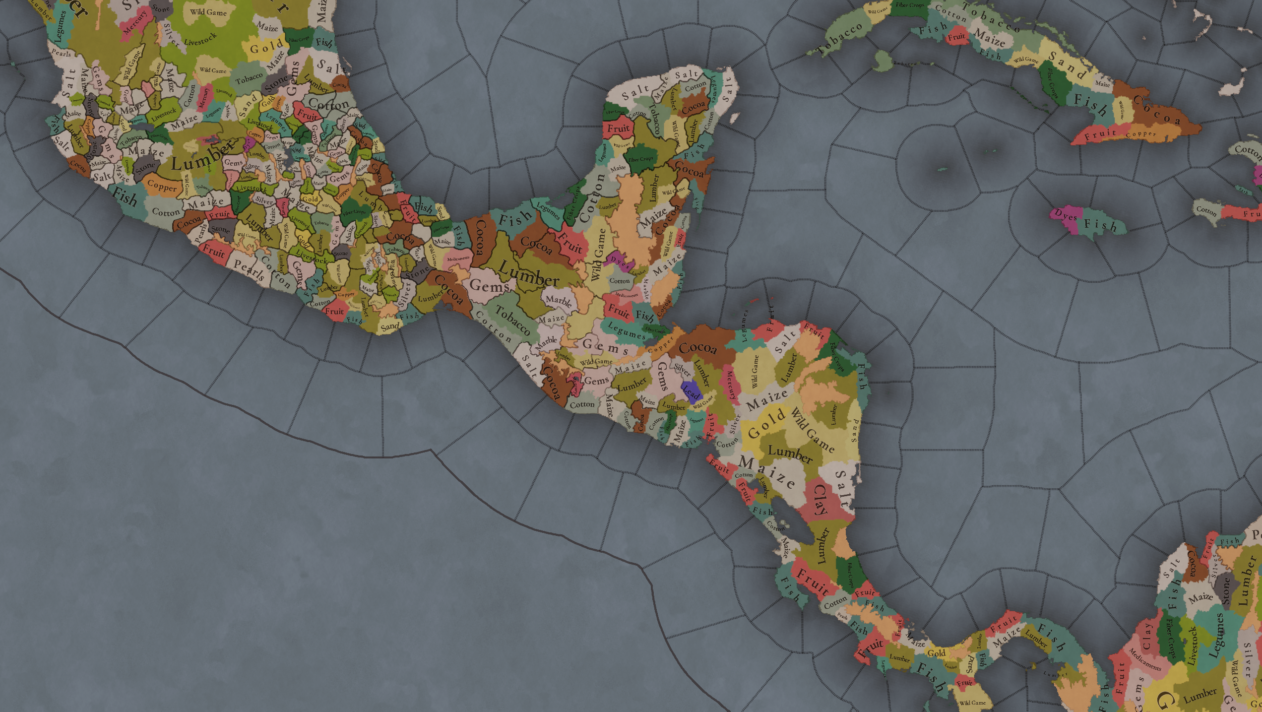
Maize is king in Mesoamerica, although there are plenty of other resources, including juicy Gold and Silver. Obsidian is not a separate resource, as it’s too regional-specific, so it’s included under the Gem coverage, but we have ways to represent it in-game; for instance, there’s a production method to produce Weaponry using Gems as an input.

Markets
Markets.png

A couple of bugs were reported while taking the screenshot of this map! But well, you can see that Azcapotzalco, Màayapáan, and Noh Petén (capital of the Itza people) are the most important ones.

Population
Population1.png

Population2.png

Population3.png

Population4.png

Population5.png

Population6.png

Population7.png

We have solved a couple of issues with the pop editor, and this week this map is in a decent state to be shown! Yay! Total numbers in the region are roughly 8.6M pops, distributed this way:
  • 523K in Aridoamerica (includes the lands to the North-West of the Purepecha Empire)
  • 6.947M in Mesoamerica (including North-Western Mayan lands)
  • 1.003M in Central America (including South-Eastern Mayan lands)
  • 151K in the Caribbean Islands

And that’s all for today! We hope you enjoyed these meaty maps! Next week we will be taking a look at the Levant Feedback, on Monday 16th, and South America, on Friday 20th! Cheers!
 
  • 113Like
  • 95Love
  • 5
  • 1
Reactions:
I've been waiting this moment for a long time.

I'm very pleased with the cultures, religion and society of pops in Cuba, but I feel the obligation of suggest better locations for my beloved island. I apologize because my sugestions are a little bit based on the colonial settlements, but I must say the team made an outstanding work looking for the native names of the different locations.

Well, here are my suggestions:

Silly Cuban Provinces Propuest.jpg


Western Area:
1. Mantua. The location now has the town of Mantua inside, which was for a very long time the western town in Cuba.
2. Pinar del Rio. Same location, but without Mantua.
3. Mariel/Guanajay/Artemisa. Lots of names to pick.
4. Isla de Pinos. PLEASE, DO NOT NAME THIS LOCATION AS 'ISLA DE LA JUVENTUD', PLEASE.
5. La Habana/Havana. The 5th of the initial seven settlements. I suggest to remove the bits around the Matanzas Bay.

Matanzas Area:
6. Matanzas. A location around the Matanzas Bay.
7. Zapata. Its a province engulfing the Zapata Swamps.
8. Cardenas/Jovellanos. A location around this two towns.
10. Colon. A location around a lesser crossroad.

Central Area:
9. Jagua/Cienfuegos. The location actually has the Jagua/Cienfuegos Bay inside.
11. Sagua la Grande. Quite notably important river town.
12. Remedios. The first town built after the seven initial settlements.
13. Santa Clara. The mayor crossroad of Cuba. Important comercial hub and a very important sugar producer location later on.
14. Guamuhaya/Escambray. The location now engulfes the Guamuhaya or Escambray mountains (the highest place is 1.140 m above the sea).

Trinidad Area:
15. Moron.
16. Sancti Spiritus. The 4th of the initial seven settlements, and the only one originally founded inland.
17. Trinidad. The 3rd of the initial seven settlements.
18. Jucaro. I could suggest name this location Ciego de Avila, but that city was founded in 1840.

Puerto Principe/Camaguey Area:
19. Puerto Principe/Nuevitas. This area was where the 6th of the initial settlements was founded as the 'Villa de Puerto Principe' but later on was moved to the inland. The Nuevitas town is built around the Nuevitas Bay, the place where the Puerto Principe settlement was established, acording to records.
20. Puerto Principe/Camaguey. The inland settlement of Puerto Principe, the 6th of the initial settlements.
21. Vertientes. The first port to the south in the Puerto Principe/Camaguey area.
22. Guaimaro/Santa Cruz del Sur. Both towns are a good fit here. I like Santa Cruz, but Guaimaro is historically more important.

Bayamo Area:
23. Puerto Padre.
24. Victoria de Tunas/Las Tunas.
25. Bayamo. The 2nd of the initial seven settlements. My suggestion is removing Manzanillo out of it.
26. Manzanillo. The location actually have the city of Manzanillo now.
27. Contramaestre/Holguin/San German. This location is in an awkward position. Holguin is in the limit with the northern location; Contramaestre is in the limit of the southern location; and San German is a little town in the middle of the location.
28. Banes/Holguin. I'm not sure which town should be the relevant one for this location. Could be Banes, north to the Nipe Bay. Could be Holguin, right in the border with the previous location.

Eastern Area:
29. Mayari. An interesting town near the largest bay in Cuba: the Nipe Bay.
30. Santiago de Cuba. The last of the initial seven settlements and the first capital of Cuba. I suggest a more moderate location and leaving Guantanamo outside of it.
31. Sagua de Tanamo. Quite notable town around the bay with the same name and north to Guantanamo.
32. Guantanamo. I suggest to make Guantanamo a different location to reduce Santiago's location and portray a more acurate map for possible colonial struggles (The English tried to colonize Guantanamo under the name of Cumberland, but the colony failed due to the complicated orography and the hostility from the Spanish, natives, and fugitive slaves).
33. Baracoa. The first colonial settlement in Cuba.
 
  • 6Like
  • 2Love
  • 2
  • 1
  • 1
Reactions:
Delightful map, however the population numbers seem far too low; The Native Population of the Americas in 1492 reaches a very convincing estimate of 22 million in Central Mexico by the time of European contact, which would seem to imply on this map a population growth of 15 million in a comparatively short time. I believe this number is even lower than the relatively low number that William T. Sanders reaches in The Basin of Mexico: Ecological Processes in the Evolution of a Civilization; in general, the number seems to hover around the low twenty million, whereas these numbers reliably very lowballed. Cholollan/Cholula here, for instance, is estimated at 25,378 people, which is a far cry from the 100,000 people that we reliably knew it had in 1519 after disease and Spanish rule had done their number on the city. Certainly, we cannot expect Cholollan to have such a size at this time, but easily double what it is estimated at here. By the time of European contact, Tenochtitlan exceeds any given European metropolis in size, and Kukulkan's Realm: Urban Life at Ancient Mayapan makes the very salient argument to compare the Yucatan to Germany in urbanization, density, and population. In no uncertain terms, more people lived in the Maya world than do so today.

Beyond that, absolutely delightful map, overjoyed to see such a thorough treatment, and one can see you have done your research by not going for the obvious (and pejorative) "Tarascan Empire", and instead the somewhat awkward coining P'urhépecherio. If I may, I would suggest Iréchikwa Ts'intsúntsani, or simply Tsintsúntsan, or Tzintzuntzan, after its capital, as P'urhepécha at the time referred not to a general population, merely to commoners. It is only after the fall of the empire that this term undergoes a transition to a demonym. Obviously, I do not begrudge your choice here though, as it is a difficult one to navigate.
 
  • 11Like
  • 9
  • 1
Reactions:
in general, the number seems to hover around the low twenty million, whereas these numbers reliably very lowballed.
Estimates in the low 10s millions are just as common even in "recent" books such as "Postclassic Mesoamerican World"

Edit: Also what exactly is convincing about the estimate? The book you cited itself says they are quite contested:

"Another recalculation of the Indian population of Central Mexico based onthe Borah and Cook data is by Slicher van Bath (1978). By adjusting the factorfor converting tributary counts to total populations, he reduces the Borah andCook total of 25.2 million for 1518 by 15 percent to obtain 21.42 million,a number still too high for some interested scholars.Henige also criticizes Borah and Cook for their methodology for derivinga 1519 population from Aztec tribute data: "I find the methods adopted byBorah and Cook for Central Mexico even less acceptable than their results"(Henige, 1978b: 711). Another critique is that of Jacques Houdaille (1986),who refers to the "resultats sensationnels de l' ecole de Berkeley."

Where exactly is the 22 million estimates from? Edit: So the estimate made by Sanders is 21.4 million for Mexico and 5.6 million for Central America. So 27 million from Northern Mexico to Panama I guess
 
Last edited:
  • 2
  • 1Like
Reactions:
I've been waiting this moment for a long time.

I'm very pleased with the cultures, religion and society of pops in Cuba, but I feel the obligation of suggest better locations for my beloved island. I apologize because my sugestions are a little bit based on the colonial settlements, but I must say the team made an outstanding work looking for the native names of the different locations.

Well, here are my suggestions:

View attachment 1230952


Western Area:
1. Mantua. The location now has the town of Mantua inside, which was for a very long time the western town in Cuba.
2. Pinar del Rio. Same location, but without Mantua.
3. Mariel/Guanajay/Artemisa. Lots of names to pick.
4. Isla de Pinos. PLEASE, DO NOT NAME THIS LOCATION AS 'ISLA DE LA JUVENTUD', PLEASE.
5. La Habana/Havana. The 5th of the initial seven settlements. I suggest to remove the bits around the Matanzas Bay.

Matanzas Area:
6. Matanzas. A location around the Matanzas Bay.
7. Zapata. Its a province engulfing the Zapata Swamps.
8. Cardenas/Jovellanos. A location around this two towns.
10. Colon. A location around a lesser crossroad.

Central Area:
9. Jagua/Cienfuegos. The location actually has the Jagua/Cienfuegos Bay inside.
11. Sagua la Grande. Quite notably important river town.
12. Remedios. The first town built after the seven initial settlements.
13. Santa Clara. The mayor crossroad of Cuba. Important comercial hub and a very important sugar producer location later on.
14. Guamuhaya/Escambray. The location now engulfes the Guamuhaya or Escambray mountains (the highest place is 1.140 m above the sea).

Trinidad Area:
15. Moron.
16. Sancti Spiritus. The 4th of the initial seven settlements, and the only one originally founded inland.
17. Trinidad. The 3rd of the initial seven settlements.
18. Jucaro. I could suggest name this location Ciego de Avila, but that city was founded in 1840.

Puerto Principe/Camaguey Area:
19. Puerto Principe/Nuevitas. This area was where the 6th of the initial settlements was founded as the 'Villa de Puerto Principe' but later on was moved to the inland. The Nuevitas town is built around the Nuevitas Bay, the place where the Puerto Principe settlement was established, acording to records.
20. Puerto Principe/Camaguey. The inland settlement of Puerto Principe, the 6th of the initial settlements.
21. Vertientes. The first port to the south in the Puerto Principe/Camaguey area.
22. Guaimaro/Santa Cruz del Sur. Both towns are a good fit here. I like Santa Cruz, but Guaimaro is historically more important.

Bayamo Area:
23. Puerto Padre.
24. Victoria de Tunas/Las Tunas.
25. Bayamo. The 2nd of the initial seven settlements. My suggestion is removing Manzanillo out of it.
26. Manzanillo. The location actually have the city of Manzanillo now.
27. Contramaestre/Holguin/San German. This location is in an awkward position. Holguin is in the limit with the northern location; Contramaestre is in the limit of the southern location; and San German is a little town in the middle of the location.
28. Banes/Holguin. I'm not sure which town should be the relevant one for this location. Could be Banes, north to the Nipe Bay. Could be Holguin, right in the border with the previous location.

Eastern Area:
29. Mayari. An interesting town near the largest bay in Cuba: the Nipe Bay.
30. Santiago de Cuba. The last of the initial seven settlements and the first capital of Cuba. I suggest a more moderate location and leaving Guantanamo outside of it.
31. Sagua de Tanamo. Quite notable town around the bay with the same name and north to Guantanamo.
32. Guantanamo. I suggest to make Guantanamo a different location to reduce Santiago's location and portray a more acurate map for possible colonial struggles (The English tried to colonize Guantanamo under the name of Cumberland, but the colony failed due to the complicated orography and the hostility from the Spanish, natives, and fugitive slaves).
33. Baracoa. The first colonial settlement in Cuba.

Years ago I made a small mod for the Caribbean, and tried to use the indigenous names for the provinces (very difficult). I still don't like Paradox using Spanish names for pre-Columbian America, looks very out of place.
 
  • 3Like
Reactions:
I've been waiting this moment for a long time.

I'm very pleased with the cultures, religion and society of pops in Cuba, but I feel the obligation of suggest better locations for my beloved island. I apologize because my sugestions are a little bit based on the colonial settlements, but I must say the team made an outstanding work looking for the native names of the different locations.

Well, here are my suggestions:

View attachment 1230952


Western Area:
1. Mantua. The location now has the town of Mantua inside, which was for a very long time the western town in Cuba.
2. Pinar del Rio. Same location, but without Mantua.
3. Mariel/Guanajay/Artemisa. Lots of names to pick.
4. Isla de Pinos. PLEASE, DO NOT NAME THIS LOCATION AS 'ISLA DE LA JUVENTUD', PLEASE.
5. La Habana/Havana. The 5th of the initial seven settlements. I suggest to remove the bits around the Matanzas Bay.

Matanzas Area:
6. Matanzas. A location around the Matanzas Bay.
7. Zapata. Its a province engulfing the Zapata Swamps.
8. Cardenas/Jovellanos. A location around this two towns.
10. Colon. A location around a lesser crossroad.

Central Area:
9. Jagua/Cienfuegos. The location actually has the Jagua/Cienfuegos Bay inside.
11. Sagua la Grande. Quite notably important river town.
12. Remedios. The first town built after the seven initial settlements.
13. Santa Clara. The mayor crossroad of Cuba. Important comercial hub and a very important sugar producer location later on.
14. Guamuhaya/Escambray. The location now engulfes the Guamuhaya or Escambray mountains (the highest place is 1.140 m above the sea).

Trinidad Area:
15. Moron.
16. Sancti Spiritus. The 4th of the initial seven settlements, and the only one originally founded inland.
17. Trinidad. The 3rd of the initial seven settlements.
18. Jucaro. I could suggest name this location Ciego de Avila, but that city was founded in 1840.

Puerto Principe/Camaguey Area:
19. Puerto Principe/Nuevitas. This area was where the 6th of the initial settlements was founded as the 'Villa de Puerto Principe' but later on was moved to the inland. The Nuevitas town is built around the Nuevitas Bay, the place where the Puerto Principe settlement was established, acording to records.
20. Puerto Principe/Camaguey. The inland settlement of Puerto Principe, the 6th of the initial settlements.
21. Vertientes. The first port to the south in the Puerto Principe/Camaguey area.
22. Guaimaro/Santa Cruz del Sur. Both towns are a good fit here. I like Santa Cruz, but Guaimaro is historically more important.

Bayamo Area:
23. Puerto Padre.
24. Victoria de Tunas/Las Tunas.
25. Bayamo. The 2nd of the initial seven settlements. My suggestion is removing Manzanillo out of it.
26. Manzanillo. The location actually have the city of Manzanillo now.
27. Contramaestre/Holguin/San German. This location is in an awkward position. Holguin is in the limit with the northern location; Contramaestre is in the limit of the southern location; and San German is a little town in the middle of the location.
28. Banes/Holguin. I'm not sure which town should be the relevant one for this location. Could be Banes, north to the Nipe Bay. Could be Holguin, right in the border with the previous location.

Eastern Area:
29. Mayari. An interesting town near the largest bay in Cuba: the Nipe Bay.
30. Santiago de Cuba. The last of the initial seven settlements and the first capital of Cuba. I suggest a more moderate location and leaving Guantanamo outside of it.
31. Sagua de Tanamo. Quite notable town around the bay with the same name and north to Guantanamo.
32. Guantanamo. I suggest to make Guantanamo a different location to reduce Santiago's location and portray a more acurate map for possible colonial struggles (The English tried to colonize Guantanamo under the name of Cumberland, but the colony failed due to the complicated orography and the hostility from the Spanish, natives, and fugitive slaves).
33. Baracoa. The first colonial settlement in Cuba.
Awesome suggestions

I don't know if you plan on doing a review on topography and trade goods, but I'd like to suggest modern-day Santiago, Guantanamo and Baracoa as mountains - maybe even location 26 (Granma) could be mountains as well.
What are your thoughts concerning the Escambray, mountains or hills?

As for raw goods, both Santiago and Guantanamo should, imo, be copper producing locs.

As for natural harbors, not even mentioning Havana for obvious reasons, but Cienfuegos, Santiago and Guantanamo should be very high (if not top notch). Matanzas and its bay also make for a very good harbor.

Best regards
 
  • 2
  • 1Like
Reactions:
Years ago I made a small mod for the Caribbean, and tried to use the indigenous names for the provinces (very difficult). I still don't like Paradox using Spanish names for pre-Columbian America, looks very out of place.
I used the 'colonial' names because, sadly, I do not know the native names for the locations I suggested
 
Awesome suggestions

I don't know if you plan on doing a review on topography and trade goods, but I'd like to suggest modern-day Santiago, Guantanamo and Baracoa as mountains - maybe even location 26 (Granma) could be mountains as well.
What are your thoughts concerning the Escambray, mountains or hills?

As for raw goods, both Santiago and Guantanamo should, imo, be copper producing locs.

As for natural harbors, not even mentioning Havana for obvious reasons, but Cienfuegos, Santiago and Guantanamo should be very high (if not top notch). Matanzas and its bay also make for a very good harbor.

Best regards
I agree.

For the Escambray, I would recomend mountains, but hills will do good as well. Also, the location of Mariel could be a decent port.

I was also thinking about the regions. Maybe the four western areas could make Western Cuba region, and the last three areas could be Eastern Cuba region.

Shout out to the location 13, best location of all.
 
  • 1Like
  • 1
Reactions:
I used the 'colonial' names because, sadly, I do not know the native names for the locations I suggested
Looking for the native names is difficult because of how the colonization process of the Caribbean was done. Also we don't have ease of access to their local research.
 
  • 1Like
Reactions:
Here I am again, revising my rushed suggestions from before.

Silly Cuban Provinces Propuest v2.jpg


The locations grouped in provinces will be:

Habana Province:
1. Guanahacabibes (Mantua).
2. Guaniguanico (Pinar del Rio).
3. Guanajay (Mariel/Marien/Artemisa). Decent port. (+10)
4. Siguanea (Isla de Pinos). Decent port. (+10)
5. Habana (La Habana/Havana). Really good and strategic port. (+75)

Guanimar Province:
6. Guanimar (Matanzas). Good port. (+40)
7. Western Sabaneque (Cardenas). Decent port. (+10)
8. Macorigues (Colon).
9. Hanabana (Zapata Swamps).

Jagua Province:
10. Jagua (Cienfuegos). Really good and strategic port. (+75)
11. West Cubanacan (Santa Clara).
12. Northern Sabaneque (Sagua la Grande). Decent port. (+10)
13. Southern Sabaneque (Remedios).
14. Guamuhaya (Escambray/Cumanayagua).

Moron Province:
15. Magon (Trinidad). Decent port. (+10)
16. East Cubanacan (Sancti Spiritus).
17. Eastern Sabaneque (Moron).
18. Ornofay (Jucaro).

Camaguey Province:
19. North Camaguey (Nuevitas/Puerto Principe).
20. Central Camaguey (Camaguey/Puerto Principe).
21. South Camaguey (Vertientes).
22. Guaimaro (Guaimaro/Santa Cruz del Sur).

Bayamo Province:
23. Cayaguayo (Puerto Padre). Decent port. (+10)
24. Cuciba (Victoria de Tunas/Las Tunas).
25. Bayamo.
26. Macaca (Manzanillo). Nice port. (+25)
27. Maguanes (Holguin/San German).
28. Banes (Banes/Holguin). Nice port. (+25)

Baracoa Province/ Santiago Province/ Guantanamo Province:
29. Barajagua (Mayari). Nice port. (+25)
30. Bayaquitiri (Santiago de Cuba). Really good and strategic port. (+75)
31. Guantanamo. Really good and strategic port. (+75)
32. Sagua (Sagua de Tanamo). Good port. (+40)
33. Baracoa.

Location 11 still the best location of all.

About raw materials I suggest location 30 and 31 produce copper. Regarding to the physical terrain, locations 14, 30, and 31 should be mountains, and locations 15, 29, 32, and 33, should be hills.

Also, Cuba could be splitted in two main areas: East and West, but I personally have no problem with Cuba being one single area.
 
Last edited:
  • 5Like
  • 3
  • 2Love
  • 1
Reactions:
Wasteland question
Why would there be a wasteland to the east of Rama?
1734197316639.png

Even though the area is still sparsely populated and a biological reserve, it does border the San Juan river delta and would have been used as a terminus to inland exploration. A province name for it would be tough to come up with, especially a local one, but as a suggestion it could be Voto named for the Voto people and the Voto language (related to the Rama and part of the Chibchan language family). From what I could find, they did live in the general area, more in Costa Rica than Nicaragua (The Nicaraos, the Votos Indians and the Huetares in conflict scenarios in the 16th century image below). Or go with another Nahualt speaking people as shown in the below map.
1734199956614.png


Not sure if it should be redone as Hills, Wetlands or left as Flatlands. Looking at a physical map, I'm partial to it being Hills as the flatlands only occupy the coastal areas. For culture, it would either be the Voto or Nahua per above; as for trade good it could be lumber, fish or medicaments. I'm partial to it being medicaments as it appears that this trade good is fairly sparse in Central America.

Uxarraci
I would suggest making Uxarraci, the location east of Bocto, a wetland and not flatlands.
1734197335959.png
1734197316639.png


Based on this research paper, Costa Rican wetlands vulnerability index, Uxarraci is covered by a decent portion of wetlands..
1734197587838.jpeg


Languages
For the language map mode, I feel like it at times portrayed Language families in this dev dairy and not languages. Wish there was a map mode also showcasing the language families.
1734200273836.png

I do have suggestions/recommendations, but would like to know how the language families are in Central America as I don't want to break things up into what would better be considered dialects. As others brought up, Maya, Nahuatl, Otomanguean feel more like they should be Language Families from the Language dev diary instead of individual Languages.

This is also causing me worry on Chibchan, it covers a large geographical area and people. I would propose having Chibchan be a language family and have it be split into multiple language:

  1. North Chibchan (green) - Does cover several geographically languages, but I feel that would be better for dialects especially when using the Language dev dairy and how they showcased the languages there. Could also group it with Isthmus Chibchan if it feels too small.
  2. Isthmus Chibchan (blue)
    1. Have an additional split between Isthmus and Cuna Chibchan (pink), but I don't feel that it is necessary.
  3. Muisca (for the Muisca people)
  4. Additional depending on how much ground Chibchan covers in South America
1734203842616.png


Edit
- Fixed up some typos and grammar.
 

Attachments

  • 1734201307905.png
    1734201307905.png
    470,4 KB · Views: 0
  • 1734203645578.png
    1734203645578.png
    911,4 KB · Views: 0
Last edited:
  • 10Like
  • 2
  • 1
Reactions:
Pamé language - Pamé culture to be added
Pame and Xi’oi are the same thing.
Amuzgoan language (Amuzgo culture (native name "Tzjon Noan"
I like the idea of adding Amuzgoan, but I’m less sure that Tinto will want to add a culture that small.
Mazatec language (Mazatec culture, not yet presen, native to northern northern Tuxtepec district)
One comment I have is that the language branch is called Popolocan, so if you’re including Mazatec and Chocho, you might as well name it after the branch.

1734166918731.png

Here is a culture map of an area (Nuu Savi marked Mixtec for convenience)
I think Popolocan, Mazatec, and Chocho are, like Amuzgo, just a bit too small on their own; I think it would make for a more convincing case for Tinto to combine the three into one.
 
  • 6
  • 2
Reactions:
I think Popolocan, Mazatec, and Chocho are, like Amuzgo, just a bit too small on their own; I think it would make for a more convincing case for Tinto to combine the three into one.
Indonesian map has one culture per 1-2 provinces. Popolocan together with Mazatec and Chinantec would probably be like 8-10? They still can be united under some Nuu Savi language, tho
 
  • 3Like
  • 1
Reactions:
Pame and Xi’oi are the same thing.

I like the idea of adding Amuzgoan, but I’m less sure that Tinto will want to add a culture that small.

One comment I have is that the language branch is called Popolocan, so if you’re including Mazatec and Chocho, you might as well name it after the branch.


I think Popolocan, Mazatec, and Chocho are, like Amuzgo, just a bit too small on their own; I think it would make for a more convincing case for Tinto to combine the three into one.
In some places they add Hebrews, who are not even visible on the map, but here they would "deny" a culture that would only have one location in the majority? I don't know why they would generalize if the game engine allows them to have so much more than in EU IV. Maybe I'm just a little frustrated that our culture didn't exist in previous EU games (except with the later EU IV updates).
 
  • 4
  • 1Like
Reactions:
It's really hard to tell how things work with the islands in the Antilles region. Is every island even the smallest ones a location? Or are they grouped together?
Are Saba and St. Eustatius each a a location or grouped? Are Anguilla, Sint Maarten, St. Barts grouped or each an own location? The Virgin islands?

St. Eustatius had a famous harbor and was a Center of Trade and was known as the Golden Rock eventually. This might be nice to work into the game.

Curacao and Sint Maarten should be Salt and trade good and not fish. The Dutch choose their island for Salt for salting their herring. Sint Maarten was known as Souliga, land of Salt.

The North Eastern Antilles should be woods not jungle. It's too dry to be considered a jungle. (Anguilla, Sint Maarten, St. Barts, St. Eustatius, Antigua, Barbuda and Cuaynia (in Puerto Rico) should probably be woods not jungle.

Sint Maarten and Saba should be Hills not flatland. Saba maybe even mountain. It's just an 800m Hill sticking out of the sea.
 
  • 1
  • 1
Reactions:
Hello, i am from Venezuela, and i think that this map have few mistakes, first of all, the "Itchitki" Location in the guajira is actually a dessert, same think that "Punto Fijo" the amount of vegetation in the Venezuelan flat land have more grassland that woods, but the actual amount of the map is pretty similar. second, the Guajiros or "Wayuus", the Wayuus should be more that the actual population that is represented in this map, and should be a society of pops or a playable country like the Mapuches, because first of all, in Venezuela we have arount 255,000-400.000 Wayuus (And most of Zulians, the people of my city Maracaibo have Wayuu blood, approximately 800,000 people), way more Natives that any other group in Venezuela, so in the time, they should be like 30.000-50.000 Wayuus, they have their own lenguage and dictionary, their own words and even autonomy, not only right now, even during the colony they managed to have autonomy since the Spanish were unable to control them, the Wayuu folk is vast and more way complex if we compared it with other Cultures in Venezuela, and, so in complexity they may be more like the Mapuches, that have even their own form of tribal goverments, the guajiros have a semi nomadic life style since ever based in lifestock and trade, i know that obtain information of Cultures like that is hard, but actually the Wayuus are more influential and important in the Venezuelan and Colombian history that is generally know, and have a heavy
contribution in the culture and dialects/Acents of our peoples, and is general knowledge of the people of My region, my city and regions in colombia that have heavy influence of the Wayuu people that is like that.
 
  • 3Like
  • 3
Reactions:
Looking at the province and area map modes, the Panama and Nekokiaw areas look different with the Panama area going up the coast and almost touching the Imabite area.
1734220477141.png


On top of that, in the province map mode, the Nekokiaw province has the same importance as the Panama province as these two appear to be the only two provinces that touch both the Caribbean Sea and the Pacific Ocean giving them high importance for nations looking to transfer armies between the two theaters.
1734220652923.png


I would make the suggestion of breaking up the Tarianca into Tarianca (blue) in the west and Tjër Di (red, named for the river called Teribe in Spanish which is important to the Naso people) in the east. Tarianca would be added to Nekokiaw area, while Tjër Di would stay in Panama area. Going further to even out the location count, I would break Uxarraci into two location
  1. Uxarraci, could stay as flatlands
  2. Chirropo, named after a river flowing there, this would be the wetlands I suggested in the earlier post. trade good could be fruits
The final thing would be taking the locations (circled in white) of Rama, Voto (suggested in this post), Kukra and Gorda (white 1, couldn't find a local non-Spanish name, it would be wetlands, trade good could be fruits and culture would be Ulwas) and making it into a new province. This would make the Matagalpa and Mayagna provinces nearly landlocked and increase the time it takes to get to them.

Provinces
1734223837655.png


Areas
1734223913765.png
 
  • 3Like
Reactions: