• We have updated our Community Code of Conduct. Please read through the new rules for the forum that are an integral part of Paradox Interactive’s User Agreement.

Tinto Maps #29 - 13th of December 2024 - Central America

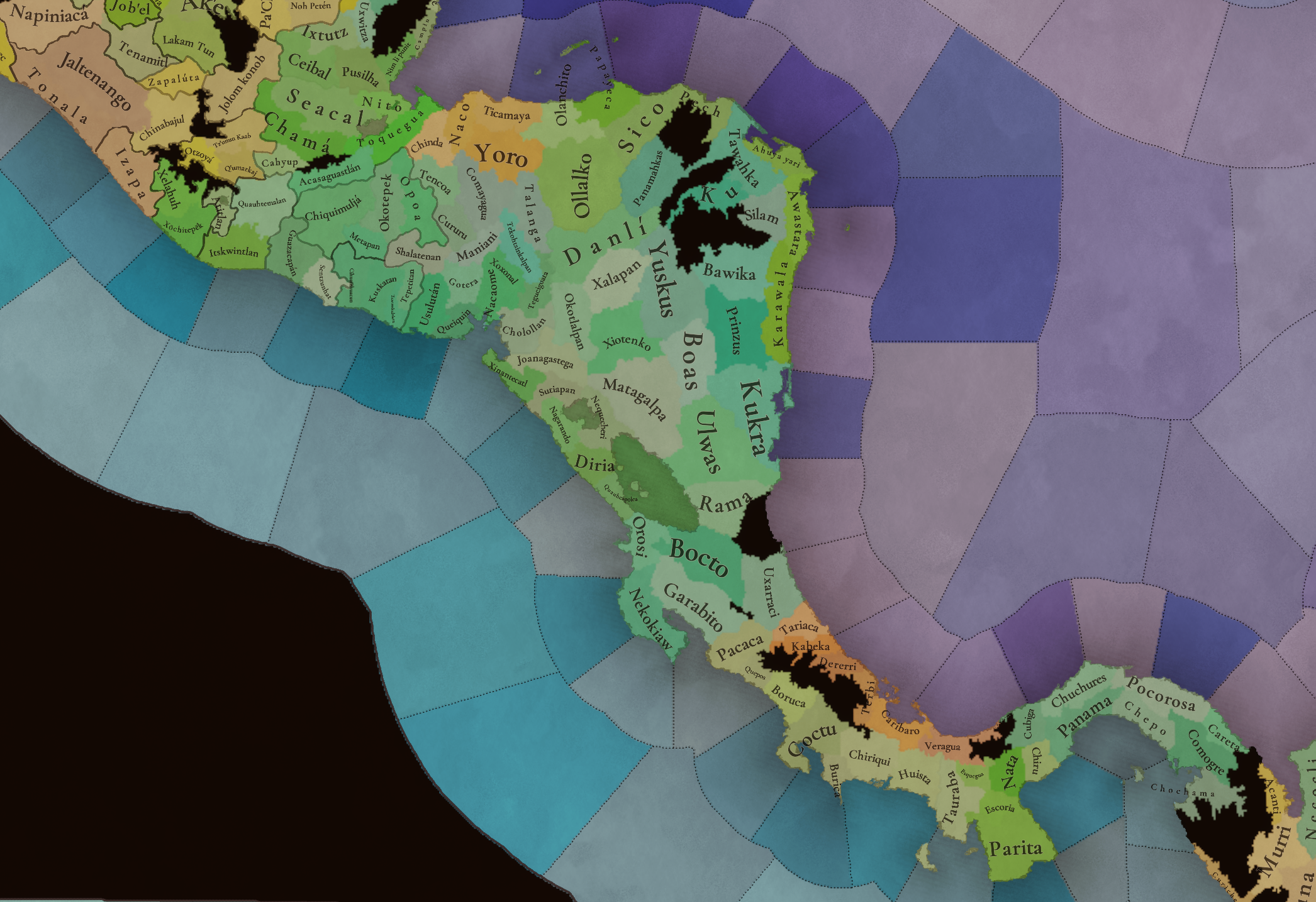
Hello everybody, and welcome to Tinto Maps, the happy Fridays for map lovers! Today, we will be looking at Central America, which includes the Caribbean. Before we start, I want to introduce you @RaulTrullenque , the only member of our Content Design team who had not yet gone public, and who worked really hard on the maps and content of the Central American and South American regions.

And now let’s get started without further ado!

Countries
Countries1.png

Countries2.png

Countries3.png

Countries4.png

Countries5.png

Countries6.png

Countries7.png

Tenochtitlan.png

Mayan.png
Welcome to the Mesoamerican Thunder Dome! This area is characterized by its numerous Altepetl, more or less comparable to city-states. Most of them are ruled in 1337 by peoples of Nahua origin, something that you may see much more clearly in the culture map. The biggest power in this moment is the Empire of P’urhépecherio, though, founded by the Purepecha people. In any case, you may notice that there’s a lot of detail in this area, including a tiny Nahua settlement recently founded on an island over Lake Texcoco, Tenochtitlan. This is the first time in a PDX GSG that we have the island itself present on the map, although the location covers some more land over the lake coast, to make it playable. Finally, we also have the Mayan polities of the Postclassic Period, of which Cocom, with its capital Màayapáan, was the most important, along with others, such as K’iche’ and its capital Q’umarkaj.

SoPs
SoPs1.png

SoPs2.png

SoPs3.png

SoPs4.png
On the outskirts of the Mesoamerican polities, there are plenty of peoples organized on different ways. To the north, we have the ones that populate the area known as Aridoamerica, which were collectively termed by the Nahua as ‘Chichimeca’. We also have plenty of societies close to the Mayan lands and the Isthmus. And, finally, the Taíno people populate some of the biggest islands in the Caribbean.

Locations
Locations1.png

Locations2.png

Locations3.png

Locations4.png

Locations5.png

Locations6.png

Locations7.png

Locations8.png

Plenty of locations here! I just want no note that the Darien Gap is an impassable wasteland, which means that any army trying to cross from modern Panama and Colombia will need transport ships to be able to do it.

Provinces
Provinces1.png

Provinces2.png


Areas
Areas1.png

Areas2.png


Terrain
Climate.png

Climate2.png

Topography.png

Vegetation.png

Vegetation2.png

A very diverse region! Most of it is covered by Tropical Jungles and Forests, but Sierra Madre Occidental and Oriental make for very specific conditions in the Mexican Altiplano, which are not only visible in the Topography map but also in the climate and vegetation of the area.

Development
Development2.png

The most developed regions in Mesoamerica are the Valley of Mexico and the Mayan coastline.

Natural Harbors
Harbors.png

There are some good ports in the Caribbean, no surprise that most of them would later become important cities in the Colonial Period.

Culture
Cultures.png

Cultures2.png

Tons of cultures!

Language
Dominant Languages1.png

Dominant Languages2.png

Court Language.png

And also languages! The first two maps are the Dominant Languages per location, while the third is the Court Languages one. The dark blue language is ‘Totozoquean’, as it is not so easily readable (something we have to change).

Religions
Religions.png

This map is today in a more advanced state, as we have merged plenty of cultural religions into regional groupings. Of these, Tonalism, Nahua, and Mayan are part of the Tonalist religious groups, while the others are part of the Folk American group (a regional split of the former ‘Animist’ group). Nahua and Mayan have their different mechanics, which we’ll talk about in future Tinto Talks. Let us know what do you think of this design and any suggestions about the religious grouping!

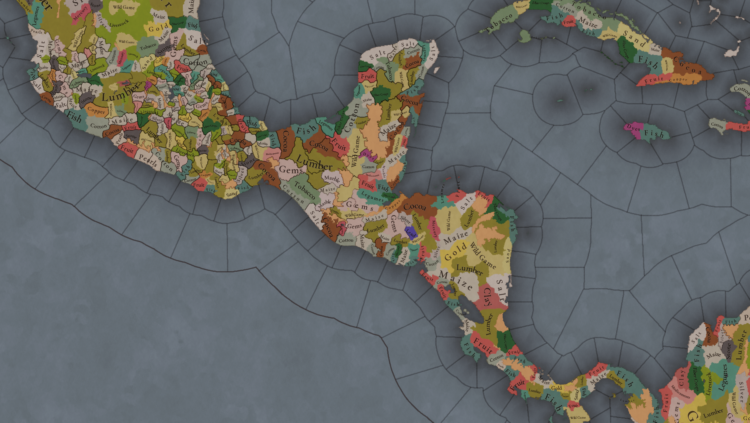
Raw Materials
Raw Materials1.png

Raw Materials2.png

Raw Materials3.png

Raw Materials4.png

Maize is king in Mesoamerica, although there are plenty of other resources, including juicy Gold and Silver. Obsidian is not a separate resource, as it’s too regional-specific, so it’s included under the Gem coverage, but we have ways to represent it in-game; for instance, there’s a production method to produce Weaponry using Gems as an input.

Markets
Markets.png

A couple of bugs were reported while taking the screenshot of this map! But well, you can see that Azcapotzalco, Màayapáan, and Noh Petén (capital of the Itza people) are the most important ones.

Population
Population1.png

Population2.png

Population3.png

Population4.png

Population5.png

Population6.png

Population7.png

We have solved a couple of issues with the pop editor, and this week this map is in a decent state to be shown! Yay! Total numbers in the region are roughly 8.6M pops, distributed this way:
  • 523K in Aridoamerica (includes the lands to the North-West of the Purepecha Empire)
  • 6.947M in Mesoamerica (including North-Western Mayan lands)
  • 1.003M in Central America (including South-Eastern Mayan lands)
  • 151K in the Caribbean Islands

And that’s all for today! We hope you enjoyed these meaty maps! Next week we will be taking a look at the Levant Feedback, on Monday 16th, and South America, on Friday 20th! Cheers!
 
  • 112Like
  • 95Love
  • 5
  • 1
Reactions:
In the latest Tinto Maps of the entire world I noticed that all mesoamerican tags are monarchies, but there did exist republics in mesoamerica. Most famously Tlaxcallan which managed to resist Aztec expansion until the Spanish arrived. Here is a good video on it.
 
  • 8
  • 2Like
  • 2
Reactions:
OK, here there is the framework of my suggestion for Western Mexico, including Michoacán, Colima, Jalisco, Nayarit, Sinaloa, Durango, Zacatecas, Aguascalientes, Guanajuato, western San Luis Potosí and southern Coahuila.

WESTERN MEXICO provinces.png
The provinces are distributed following the most relevant Altepeme and/or colonial administrative cores, while trying to fit into the scale needed for PC. Whenever possible locations are named after proper historical cities/towns with native naming. On the northern part the use of particular tribes as locations names was used only when there were no options.

WESTERN MEXICO areas.png
For the areas the mesoamearican naming for broader regions in the case of Michihuacán (Michoacán) and Chichimecapan, then post-hispanic native naming based in particular locations like Xalisco, Sinaloa and Coahuila. In the particular example of Coahuila not all the area is shown in the suggestion but it is supposed to include all of the contemporary states of Coahuila, Nuevo Léon and the northen and central Tamaulipas, the southern part of the later should be part of a Huastec area with eastern San Luis Potosi, northern Veracruz and northern Hidalgo.

Then the locations in a more detailed views with their frontiers guides and particular sites. All thje three subregions have general redrawing corrections.
guia CHICHIMECA.png
* Added the locality of Carapoa to northen Sinaloa.
* Topia is extended to high slopes while Tamazula represent the piedmonts.
* Tayoltita turn into Guarisamey and Guarisamey into Hetasi.
* Maloya is extended to include the site of Copala (near site of equal importance).
* O'dam name changed to Bayacora. Also Inde to Indehé.
* The locality of Tepecan divided into Tepec, Huexuquilla, Mezquitic and Colotlán (now Tepec is its own province).
* Added the localities of Susticacán, Xalpan and Teulinchan(Teúl) to the Teulinchan province (the others are Tlaltenango, Xochipilla adn Nochistlán).
* Yuac renamed to Chalchíhuitl. While Yamanquex, Zain and Papantón are redistributed.
* Fixed the spanish plurals in Alamama and Miopacoa.
* Since Irritila could be used in a broader sense and there is a Irritila culture in PC, Irritila locality is changed to Vasapalle. Distribution fixed in the map of cultures.
* Changed the localities of Guazapayogliglas to Bobole, Osatayogliglas to Contótor, and Cauitaome to Bauzarigame. The replaced names are from groups that should be at north/west Coahuila, the suggested correction are the ones historical for the zone.
* Use the historical and simpler name of Matehuala over a complex contemporary spelling of an uncertain native meaning. Also Hñahñu changed to Guaxaban (wrongly placed near Aguascalientes) since the Otomi from Mezquital Valley should be to the southeast while the Guaxaban were the ones living around Santa María del Río.
* Added Wirikuta and Maticoya to western San Luis Potosí.
* On the region around Aguascalientes, Sauza in singular form, the mentioned Guaxaban(on Aguascalientes) changed to Tepezalá, and Cuxtaque changed to Pechititlán (current Lagos de Moreno).
* Teocaltiche instead of Mezquititlan, since the sources always note the first Tecuexe later Caxcan Teocaltiche as a more relevant site.
* From what is now Guanajuato the Pechichitane location changed to Coecillo, Mooti to the recognized Quanaxhuato, Penlamu to Epénxamu, the uncertain Xiriquitzio to Irapuato, and "Nat tha hi" to the historical Apatzeo.
* Divide the "Otomitl" location on northeast Guanajuato into Quijay and Xichú locations.

guia TONALA.png
***Details to be added soon***

guia MICHOACAN.png
***Details to be added soon***

Here also the map for the cultures.
WESTERN MEXICO culture.png
* Considering that we have SOP it is kind of redundant to have small cultures for single SOP tags when could be more efficient to when possible have various SOP tags sharing common cultures, for example the Cahita culture would include Mayo and Yaqui SOPs instead of these being 1SOP cultures.
* Guasave culture could be represented but there were coastal fishermen that were far from control the whole locations shared with inland Cahita peoples.
* Irritila is an umbrella term for a likely heterogenous group but we lack sources to classify them anyway. What is fixed is the location of the particular groups.
* Corachol (Cora+Huichol) were in definitive broader distributed, even now are the more significative group of the region. Still the early sources mix a lot the names Coras, Coanos, Tepehuanes, Tepecanos, Huaynamotas, Caramotas, Huazamotas, Tecaules, Xuxucte Cuanes, Uzares, Tezoles, Huicholes, Vizuritas, etc. So is safer to have Corachol and Tepecan.
* Southern Jalisco was shared by Sayultecas(Tzaultecas) of likely Nahua affinity and the Pinome and "Otomi", these later could have be the same groups of at least Otomanguean/non-Utoaztecac peoples. So since there are already the Otomi the name Pinome would be the best option.
* Tecuexe and Coca are two related but clearly different and relevant groups for the region.
* Teco cover similar situation to Pinome, when nahua peoples were well know always present with the spaniards there was a differentiation. Here the Purepecha identification of the Tecos in relation to the Nahua could be problematic being "outer-group".
* Guamar and Pame fixed in their distribution.
* Mazahua could be separated from the Otomi.
* Since there is more certainty that Cuyutec were a group of Nahua I leave this to consideration of if is the best option in terms of game mechanics to keep all Nahua as the same or different groups.

  • Aguilar-González, J. R. 2005. Tzintzuntzan Irechequa. Política y sociedad en el Estado Tarasco. Universidad Michoacana de San Nicolás Hidalgo.
  • Aguilera-Calderón, R. 2018. Corporeidad, gestualidad e intransigencia: Las danzas entre los Xi’oi (Pames) de Santa María Acapulco. Universidade Federal do Pará.
  • Balboa-Trasviña, M. A. 2007. La conquista de la provincia de Sinaloa y la evangelización de los indios Zuaques de Mochicahui. Ra Ximhai. Vol. 3. n° 2. pp. 325-342.
  • Bernal, I. 1952. Relación de Tancítaro (Arimao y Tepalcatepec). Tlalocan. vol. 3. nº 3. pp. 205-235.
  • Bravo-Magaña, J. 1985. El significado de Colima: estudio lingüístico. Relaciones. n°24. pp. 69-90.
  • Calderón-Aragón, G. 1998. Geografía de riesgos. Fundamentos económicos y sociales. Universidad Nacional Autónoma de México.
  • Carrillo-Cázares, A. 2000. El debate sobre la guerra chichimeca, 1531-1585: Cuerpo de documentos. El Colegio de Michoacán.
  • Cárdenas-Munguía, F. J. 2000. Los asentamientos humanos en el siglo XVII en la provincia de Colima. Sistema de poblados y su estructura interna. Universidad Nacional Autónoma de México.
  • Castro-Gutiérrez, F. 2006. La colonización del pasado: Pénjamo y la memoria del poblamiento de las fronteras novohispanas. Fronteras de la Historia. nº 11. pp. 121-151.
  • Chávez-Hernández, G., y Mancilla-Aguilar, L. A. 2010. San Luis de la Paz. Nación Chichimeca. Gobierno del Estado de Guanajuato.
  • Delgadillo-Galindo, S. 2019. La resistencia ante la conquista de la Sierra Madre Occidental (1563-1618). Los casos Acaxee y Xixime. Universidad Juárez del Estado de Durango.
  • Delgadillo-Galindo, S. 2020. El primer contacto y dominio de los acaxees y xiximes. Revista de Historia de la UJED. nº 12. pp. 7-34.
  • Delgadillo-Galindo, S. 2020. El proceso de extinción de los acaxees y xiximes. Tribus de tradición antropófaga de la Sierra Madre Occidental entre los estados de Sinaloa y Durango. Siglos XVI-XVIII. Boletín del Archivo General de la Nación. vol. 9 n°4. pp. 9-42.
  • Diguet, L. 2013. Por las tierras occidentales: entre sierras y barrancas. Centro de estudios mexicanos y centroamericanos.
  • Enriquez-Valencia, R. 2018. Fronteras imaginarias y representación de la alteridad en la conquista y evangelización del Gran Nayar. Oficio. Revista de historia e interdisciplina. n.°6. pp. 55-74.
  • Gallardo-Arias, P. 2022. Movilizaciones de los Pames del Norte. Cuicuilco. Revista de Ciencias Antropológicas. vol. 29. n° 85. pp. 289-310.
  • García-Ayala, G. 2018. El lago Magdalena-Etzatlán: Un análisis del paisaje a través del tiempo. Universidad Nacional Autónoma de México.
  • García-Flores, E. 2017. Patria del Cielo y de la Tierra. Universidad de Guanajuato.
  • Gerhard, P. 1986. Geografía Histórica de la Nueva España, 1519-1821. Universidad Autónoma de México.
  • Gerhard, P. 1996. La frontera norte de la Nueva España. Universidad Autónoma de México.
  • Giudicelli, C. 2008. Un cierre de fronteras…taxonómico. Tepehuanes y tarahumara después de la guerra de los tepehuanes (1616-1631). Anuario, Instituto de Estudios Históricos-Sociales. vol. 21.
  • Gómez-Canedo, Lino. 2009. Huicot: antecedentes misionales. Estudios de Historia Novohispana. nº 9. pp. 95-145.
  • Goyas-Mejía, R. 2011. Pueblos indios y propiedades en la alcaldía mayor de La Barca durante el virreinato. LiminaR, Estudios Sociales y Humanísticos. vol. IX. n.°2. pp. 165-180.
  • Goyas-Mejía, R. 2013. Asentamientos y pueblos indios desaparecidos en Los Altos de Jalisco durante el virreinato. Signos Históricos. n.°30. pp. 32-63.
  • Goyas-Mejía, R. 2017. Selvas yermas. Los pueblos de indios desaparecidos en la costa sur de la Nueva Galicia durante el periodo colonial. Revista de Historia Regional y Local. vol. 9. n°17. pp. 407-440.
  • Goyas-Mejia, R. 2023. Conquista y desaparición de los indígenas coanos en la Nueva Galicia. Revista de historia de América. n°2. pp. 2-28.
  • Goyas-Majia, R. 2024. Pueblos de indios y tierras en las Fronteras de Colotlán durante el siglo XVIII. Secuencia. n°119.
  • Griffin, W. B. 1969. Culture change and shifting populations in central Northern Mexico. Anthropological papers of the University of Arizona, n° 13.
  • Güereca-Durán, R. E. 2016. Milicias indígenas en la Nueva España, reflexiones del derecho indiano sobre los derechos de guerra. Universidad Nacional Autónoma de México Instituto de Investigaciones Jurídicas.
  • Jaramillo-Arango, A., Cossich-Vielman, M. and Navarrete-Linares. 2021. Un mapa de la conquista de la Nueva España: El ‘Lienzo de Tlaxcala’. Glocalism. Journal of Culture, Politics and Innovation.
  • Lastra, Y. 2015. Los hablantes de chichimeco jonaz a través de la historia. UniverSOS, Revista de Lenguas Indígenas y Universos Culturales. nº 12. pp. 9-41.
  • López-Portillo y Weber, J. 1943. Los cronistas de la conquista de la Nueva Galicia. Memorias de la Academia Mexicana de la Historia. Tomo II. nº 3. pp. 209-230.
  • Martín-Ruiz, J. 2010. Irapuato. Colección Monografías Municipales de Guanajuato. Guanajuato, Gobierno del estado.
  • Martínez, R., and Valdez, I. 2009. Guerra, conquista y técnicas de combate entre los antiguos Tarascos. Tzintzun, Revista de estudios históricos. n.º 49. pp. 17-52.
  • Martínez-Aguilar, J. M. 2020. Formación y usos de los conventos en la provincia franciscana de Michoacán durante el virreinato. Historia Mexicana. vol. 70. nº 2. pp. 599-643.
  • Martínez-Romero, D. R. 2020. Matehuala. Poblamiento e incorporación de una zona de frontera de la América septentrional a la monarquía hispánica, 1600-1750. Centro de Investigaciones y Estudios Superiores en Antropología Social.
  • Martínez del Río, P. 1954. La Comarca Lagunera a fines del siglo XVI y principios del XVII según las fuentes escritas. Historia Novohispana, n° 9. pp. 49-94.
  • Medina-Arandas, H. 2020. Tras la pista de los Wixaritari: Los pueblos indígenas de la Sierra Madre Occidental en las crónicas tempranas (S. XVI-XVII). Revista Euroamericana de Antropología. n°9. pp. 45-60.
  • Mendieta, L. 1940. Los Tarascos. Monografía histórica, etnográfica y económica. Universidad Nacional Autónoma de México.
  • Meyer, J. 1997. Breve historia de Nayarit. El Colegio de México.
  • Mota-Padilla, M. Á. 1742. Historia de la conquista de la provincia de la Nueva Galicia. (Edición 1870. Imp. de Gobierno).
  • Novella, R. 1996. La Costa de Michoacan, Mejico, en el siglo XVI. Anales del Museo de América. n°. 4. 25-37.
  • Nicolás-Caretta, M. 2012. Asentamientos caxcanes en el Cañón de Juchipila y el primer intento del camino Real de Guadalajara a Zacatecas. Relaciones. n°130. pp. 66-90.
  • Ortega-León, V., and Grave-Tirado, L. A. 2019. Por tierras no sabidas y tan estrañas. Geografía protohistóricas de la costa noroccidental del Pacífico. La ruta de Nuño de Guzmán. Secretaria de Cultura.
  • Pacheco-Rojas, J. y Quiñones-Hernández, L. C. 2012. Formación de la Nueva Vizcaya y la fundación de la villa de Nombre de Dios. Un territorio en disputa. Revista de Historia de la Universidad Juárez del Estado de Durango. n° 4.
  • Pollard, H. P. 2004. El Imperio Tarasco en el Mundo Mesoamericano. Relaciones.vol. XXV. n° 99.
  • Pomedio, C. M., Lefebvre, K., Pasco-Saldaña, G. M., and Gutiérrez-Cruz, C. D. 2021. El mapa de Cuzalapa, Jalisco, un primer acercamiento territorial. Letras Históricas. nº 24. pp. 229-257.
  • Portillo, E. L. 1886. Apuntes para la historia antigua de Coahuila y Texas. El Golfo de México.
  • Powell, P. W. 1984. La Guerra Chichimeca (1550-1600). Fondo de Cultura Económica.
  • Pulido- Méndez, S. 2002. Etnias, lenguas y lugares en el Estado tarasco. Una revisión sobre los habitantes y sus idiomas en el Michoacán prehispánico a partir de la lectura de las Relaciones geográficas del siglo XVI. Estudios Mesoamericanos. n°3. pp. 23-33.
  • Quintero, F. L. 2007. Historia integral de la región del Río Fuerte. El Fuerte nuestra historia, Tomo 4. Creativos7.
  • Rangel-Guzmán, E. and Marín-García, J. L. 2014. Desplazamientos territoriales y nuevos asentamientos tepehuanes. Relaciones. Estudios de historia y sociedad. vol. 35. no. 137. pp. 149-178.
  • Rangel-Silva, J. A. 2009. Pames, Franciscanos y Estancieros en Rioverde, Valles y sur de Nuevo Santander, 1600-1800. Relaciones. n°120. vol. XXX. pp. 225-266.
  • Rivera-Villanueva, J. A., Riojas-López, M. E. and Mellink, E. 2019. El Tunal Grande y los tunales asociados, hábitat de recolectores cazadores. vol IX. n°19. pp. 151-176.
  • Rodriguez-Palma, B. and Gerardo-Santos, L. 2019. Bartolomé Rodríguez Palma, un clérigo minero portugués en Nueva Galicia, 1676-1698. Historia y Grafía, Universidad Iberoamericana. n°52. pp. 159-186.
  • Romero-Pérez, J. F. 2011. La conquista militar de los Altos de Jalisco. Archivo Histórico, Tepatitlán de Morelos. n°. 17.
  • Roskamp, H. 1998. La Historiografía Indigena de Michoacán, El lienzo de Jucutácato y los Títulos de Carapan. CNWS. Leiden University.
  • Salinas-Ramos, M. S. 2014. El Camino Real de Tierra Adentro y la colonización en la jurisdicción de las villas de San Miguel y San Felipe en el siglo XVI. Legajos. n.°3. pp. 45-71.
  • Sánchez, G., Carpenter, J. and Vicente, J. 2011. Catálogo científico de los de petrograbados del sitio Cerro de la Máscara, El Fuerte, Sinaloa. Instituto Nacional de Antropología e Historia.
  • Santoscoy, A. 1903. Diversos errores acerca de las lenguas indígenas del antiguo obispado y del actual arzobispado de Guadalajara.
  • Sauer, C. 1976. Colima de la Nueva España en el siglo XVI. JUS.
  • Téllez-Lozano, V. M., Miranda-García, C. M., and Fregoso-García, V. M. 2019. La construcción de paisajes políticos en la Pintura del Nuevo Reino de Galicia. Letras históricas. n.°20. pp. 239-296.
  • Valdés, C. M. 1995. La Gente del Mezquite. Los Nómadas del Noreste en la Colonia. Centro de Investigación y Estudios Superiores en Antropología Social.
  • Weigand, P. C., García de Weigand, A. 1997.Un legado prehispánico del municipio de Magdalena. Estudios Jaliscienses n.° 29. pp. 5-15.
  • Wright-Carr, D.C., and Vega-Macías, D. 2014. Los pueblos originarios del estado de Guanajuato. Pearson Educación. Universidad de Guanajuato.
    Zapata-Ramírez, T. L. 2013. Etnicidad e identidad étnica Guachichil en el Tunal Grande, 1560-1620. El Colegio de San Luis.
 
  • 8Like
  • 5Love
  • 1
Reactions:
Continuing with the central part of Western Mexico:
* The location Mezquital change name to Taxicoringa (Taxicaringa) or alternatively Xécora (Xícora).
* Nayarit location is splitted into Nayar (north) and Huaynamota (south) locations.
* Added the location of Aztatlán on the northern coast.
* The location named Tepic is clearly too big for the regional consistency and its historical relevance. So (from north to south) it turns into the locations of Huaristemba, Cactlán and Tintoc.
* Also related to Tepic, the site of Tepic is right to the northeast of Xalisco's site (the main altépetl on the zone), both are at the inland side near to "Santa María (del) Oro" site. So the proper solution is to redraw and rename the Santa María location to represent Xalisco location (Tepic turned to be more relevant until the Spanish colonial rule).
* Hostotipaquillo is another similar case. There was a altépetl relevant for the Mixton War referred as Xochitepec, but the site of proper Xochitepec was very close to the east of what is now Magdalena, heading east further to the also close Tequila. Meanwhile early sources including some of the earliest maps of the region represent more importantly the site of Guaxacatlán (Huajacatlán), this site also is more into the rough terrain that characterize the region, unlike Xochitepec at the margin of the plateau that seems to be a tributary state of the nearby Etzatlán. So on this same zone it is also the site Ostoticpac (Hostotipaquillo) that turned to be more relevant than Guaxacatlán only after the spanish retaliation and mining activity.
To add to this the spaniards used Hostotipaquillo (hispanized diminutive form to differentiate it from the more western Ostoticpac) as the administrative center to control the zone further to the northwest beyond the Santiago(Grande) and Bolaños(Tepeque) rivers and canyons. Those mountainous land to the northwest were refuge of Tepecans and Huicholes still for some more decades. So the suggestion to represent all these is to change Xochitepec to Guaxacatlán and Hostotipaquillo to Xora.
* Then the Hostoticpac to the west should be Ostoticpac. It need to be moved a little to the south that bring us to the difficulty of represent all Ostoticpac, Amaxocotlán(Mascota) and Tlalpan(Talpa). My solution is to reuse the location of Tlalpan for the Tecolotlán location at the east of Tenamaxtlán, meanwhile Amaxocotlán absorbs Talpa's zone.
* At the coast Xihutla renamed to Tuitlán.
* Allong redrawing the zones of Melahuacan, Autlán, Amollan and Zihuatlán, the coast need a couple of extra mountainous wastelands. There already are the Cacoma Sierra and Colima volcano-peak, but there were also relevant the El Cuale Sierra between Tuitlán(Xihutla) and Amaxocotlán, and the Manantlán Sierra between Autlán and the Tepetitango(Tlacalahuastla) locations.
* Huitzquillic is another location that was not that relevant for the scale, the proper representation is to extend Ameca to the east and Cocollan to the north of the valley while the mountainous south should be Tlapalpán(Tapalpa). So re-use Huitzquillic to have Tlapalpán.
* Also difficult is the situation between Zapotlán and Tochpan. Historically these two plus Tamazollan were disputed between Tzintzuntzan(Purepecha) and Colima, and later the spanish administration even used the name of the three sites for a combined administrative partition. For the scale of PC I find a separated Tamazollan justified being more to the mountainous east, but Zapotlán and Tochpan are pretty close and restrained by other locations around them. Then is better to re-use Tochpan (already are others more relevant Tochpan locations in Mesoamerica) for the Mazamitlán location to the northwest of Tamazollan.
* Cutzalan should be renamed to Tzacualco and Sayula to Tzaulan ceding some of its land to adjacent locations (Tzacualco, Tlapalpán and Mazamitlán).
* On PC's map it seems like the locations of Tlajomulco and Tala are tagless, I suppose is because at the time of the spanish conquest these were depicted as adandoned, but beyond how much this really was the case, the cause was the Purepecha invasion over 150 years after PC's starting date. So these locations should not be tagless at PC´s start.
* Add the Magdalena-Etzatlán lake to Etzatlán location.
* Change the name Huaxtla to Tecuilan (Tequila) and move this location a little to the northwest. Tequila was both a relevant native site to link the Santiago river basin to the plateau and a spanish administrative center. And yes here is from here where the Tequila destilled beverage comes.
* Considering the representation and importance of Tlaxomulco(Tlajomulco) and Tonallan(Tonalá) then is natural to also add the location of Atemaxac to cover what is now the are of proper Guadalajara (capital of all the Kingdom of Nueva Galicia) and Zapopan.
* Use Tlacotlán instead of Ixtlahuacan.
* Unlike the others Tecuexe altepeme of Los Altos the locations of Mitic and Metzquititlán do not seem to be justified at this scale when like was said before Teocaltiche is so close. Then I suggest to also re-use Mitic for the location of Ayotlán.
* Like the case of Tepic, PC's Coinan location is notoriously oversized. It should be divided into Ayotlán to the east, proper Coinan to the northwest and Cuitzeo (do not confuse with the other Cuitzeo site at northeastern Michoacán) at the southwest.

Returning a little to the northern part.
* Add the Tlahualilo lake between Mapimí and Vasapalle locations, the Mayran lake between Vasapalle, Contótor and Miopacoa, and lake Viesca between Vasapalle and Miopacoa.
* Added three mountain wastelands at the sierras and canyons of southwestern Zacatecas.
 
Last edited:
  • 4Like
  • 1
Reactions:
For the southern part of Western Mexico that covers the states of Colima and Michoacan the main changes and additions are these:
* Tlacalahuastla locality changed to Tepetitango.
* A little change to the name of Coliman to Colliman. By the way, looking deeper into Colima's name it does not seem to be a solved issue, between "Colima" the region, the site and the king. From the spanish contemporary sources like Cortés IV Carta de Relación Colima is referred as a province or kingdom, "E yendo este dicho capitán y gente a la dicha cibdad de Zacatula tuvieron noticia de una provincia que se dice Coliman..." the importance of Colliman is noted but as a region not as a leader. It was after 129 years later that we have Tello's Crónica Miscelánea de la Sancta Provincia de Xalisco talking about the king Colimán.
We know that the spanish Villa de Colima was founded under the order "y que le pusiese de nombre Coliman, como dicha provincia..." again referring the region not a leader.
I mean there are even doubts about the whole double foundation and/or relocalization of the the Villa de Colima. The first "old" spanish place of the Villa de Colima was Caxtitlán a cocoa production area near to Tecomán on the coastal zone. Then there is the second "new" Villa de Colima inland, here another issue about its relation to Tuxpan. Even more Caxitlán was supposed to be in the "provincia" of Colimotl while the "new" ville was in the "provincia" of Coliman, so yes some sources present two different areas Colimotl and Coliman, the first closer to the coast and the second inland near the volcano.
This bring us to the final controversy, the meaining of Coliman. One interpretation is that is comes from Acolman "place where the water twists" refering to a bend of the Armería river, but the other is Colliman that mean "place of the old ones" referring to both the twin volcano and snowy peak mountains that dominate the region.
So considering these alternatives and lacking a notorious alternate name for the valley, the volcano of the modern city, I think the most recognizable name of Colliman should be used for the northern location, this considering also that between the other option Caxitlán is supossed to be to the south overlapping with Tecomán.
* The coastal part of Coahuayana changed to Aliman (Alima/Alimanzi), while the northestern half should be the new location of Coalcomán.
* Add also Pomaro on the coast between Aliman(Coahuayana) and Chucutitlán.
* Take the northwestern part of Chucutitlán for the location of Arimao. Also add the mountainous wasteland of Las Conchas between Coalcomán and Arimao.
* The western part of Apatzingan turn into be the location of Tepalcatepec.
* Redraw Tancítaro and Uruapan, instead of be south>north be west>east.
* Jiquilpan should be Xiquilpan and be at the coast of Lake Chapala on the northwest from Xacona. Meanwhile add the Chocandirán location where PC have Jiquilpan.
* Take the east of Jiquilpan a little west of Erongaricuaro to add Paracho.
* Move Zacapu a little north, pass its Pátzcuaro lake coast to Tzintzuntzan.
* Turn Tiripetío into Ihuatzio by giving it the entrance to the lake Pátzcuaro between Tzintzuntzan and Pátzcuaro locations.
* Expand Tacambaro over the south of Ihuatzio(Tiripetío).
* Aguacana is more northwest>southeast oriented.
* Change Cutzeo name to Huetamo.
* The border locations on current Guerrero's side that were controled by the Purepecha need to be added in their proper suggestion, but in the map (Southern Part Localities) we can see the locations Zirándaro to be added where Cutzamala is and this Cutzamala be moved to western side of Oztoman. Add also Pungarabato between Zirándaro and Cutzamala. Some wasteland of the Sierra Madre del Sur on Guerrero should be added also.
 
Last edited:
  • 6Like
Reactions:
A few notes on area names:
  • Looks like you guys made a typo - it should be Chiapan, not Chilapan
  • Tezulutlan was only the name for Verapaz. I'd replace it with Quauhtemallan/Cuauhtemallan
  • Popocatepet is a mountain in eastern El Salvador. I think Cuzcatlan would be a better name
  • Cholollan (Cholula) was more prominent than any city of Tlaxcala, so I'd suggest renaming the area to that
  • Tzintzuntzan is alright, but you might consider renaming it to Michhuahcan, which is how the Nahuas called the area
  • Ayiti and Quisqueya are the indigenous names of Hispaniola
  • A demonym like Tamaulipeco isn't a good idea for an area name IMO. I'd suggest changing it to Tamaholipa, the Huastec origin of the state name.
 
  • 6Like
Reactions:
I want to give some comments about the P'urepecha state (Tzintzuntzan).

1737596197872.png

Greatest expanse of the Tzintzuntzani empire in XVI century

For their high degree of societal and political development, very little has been studied about the Purepecha or Tarascan people in comparison to the Nahutal or the Maya. The historical sources have been scarse and that has lead to many narratives that are currently being questioned through the advances of archeology.

In particular, I am citing the paper ""Señores” y “señoríos”: la constitución territorial en el Michoacán temprano. Una visión desde la historia y la arqueología" ("Lords" and "lordships": the territorial constitution of early Michoacán. A view from history and archeology)

Based on what we known from history (mainly the Relación de Michoacán) coupled with the latest archeological advances, there is a better picture now that never. Before, the usual narrative has been based almost exclusively on the Relación, an incomplete document written based on the official ideology of the late Tzintzuntzani state.

This document tells us a lot about Tzintzuntzan and the Patzcuarlo Lake Basin, in particular its ruling class; the Uacusechas or eagle lords. The Uacusechas were essentially a warrior clan within the larger P'urepecha cultural community, that were able to centralize power around Patzcuaro through the imposition of their military power.

1737596344214.png

A. Cazonci or Irecha, Uacusecha lord and ruler of Tzintzuntzan. B. Uacusecha general. C. Funeral mound of the Cazonic. D. Different chieftains.

This document tells us that the Tzintzuntzani state was a extremely centralized empire, where the power of the Irecha was direct and complete. Certainly, records on the conflicts between the Triple Alliance and the Tzintzuntzani state show that they had military power to back them.

Archeology, however, tells a different picture. The greater Michoacán has been inhabited for thousands of years, and great populations and cultures develop through centuries in the past before the rise of Tzintzuntzan. In the late centuries, around which the Relación de Michoacán is written, archeological records back the rise of the Uacusecha's material culture in the Patzcuaro Basin as the dominant in the record. The same can not be said of the outer dominions of the empire, in which Uacusecha culture is very scarsely found. Even when it is found, it coexists at the same time as distinct, local material cultures, either of general P'urepecha origin or corresponding to different cultures.

Does this mean the P'urepecha state was not what it claimed to be? Well, yes and no. Evidence shows that the Tzintzuntzani realm was able to establish a hegemonic empire, in which they were to militarily and diplomatically vassalize many, many distinct lords of different cultures which paid their dues to the Uacusecha capital. At the same time, the Tzintzuntzani ruler class established a very centralizing ideology, in which they clearly had great ambition to more directly rule the territories under their ideology.

At military terms, they certainly did, but the local administration remained at hands of local rulers that swore fealty to the Irecha, at least as late as the empire remained. The Relación de Michoacán mentions many local rulers in the outer lands. It's entirely possible this represents these same vassal states, that in the official state policy they declared were directly annexed, when material records shows vassaldom was more the case.

In the alternate history of Project Caesar, the Uacusechas might be finally able to achieve their ambitions. But the start situation should show their reality. At 1337, a limited dominion over the Patzcuaro Lake Basin, that would quickly in the following centuries expand and vassalize the surrounding in Michoacán. Recent historias propose 1470 as the date in which a consolidated Tzintzuntzan with similar sizes to the one shown in Tinto Maps might have appeared at the earliest.

Before the unification of the Patzcuaro Basin itself, the Uacusecha "lordships" might have looked like this:

1737597278236.png


Sources.
1. L. E. Pauwells, Jose Luis Punzo Díaz, "Señores” y “señoríos”: la constitución territorial en el Michoacán temprano. Una visión desde la historia y la arqueología", 2022
2. J. L. Punzo Díaz, J. Robles Camacho, G. Sosa Caballos, La guerra y los señores Uacúsecha en Michoacán: Sus símbolos de poder, 2020.
 
  • 4
  • 2Love
  • 1Like
Reactions:
I want to give some comments about the P'urepecha state (Tzintzuntzan).

View attachment 1246379
Greatest expanse of the Tzintzuntzani empire in XVI century

For their high degree of societal and political development, very little has been studied about the Purepecha or Tarascan people in comparison to the Nahutal or the Maya. The historical sources have been scarse and that has lead to many narratives that are currently being questioned through the advances of archeology.

In particular, I am citing the paper ""Señores” y “señoríos”: la constitución territorial en el Michoacán temprano. Una visión desde la historia y la arqueología" ("Lords" and "lordships": the territorial constitution of early Michoacán. A view from history and archeology)

Based on what we known from history (mainly the Relación de Michoacán) coupled with the latest archeological advances, there is a better picture now that never. Before, the usual narrative has been based almost exclusively on the Relación, an incomplete document written based on the official ideology of the late Tzintzuntzani state.

This document tells us a lot about Tzintzuntzan and the Patzcuarlo Lake Basin, in particular its ruling class; the Uacusechas or eagle lords. The Uacusechas were essentially a warrior clan within the larger P'urepecha cultural community, that were able to centralize power around Patzcuaro through the imposition of their military power.

View attachment 1246380
A. Cazonci or Irecha, Uacusecha lord and ruler of Tzintzuntzan. B. Uacusecha general. C. Funeral mound of the Cazonic. D. Different chieftains.

This document tells us that the Tzintzuntzani state was a extremely centralized empire, where the power of the Irecha was direct and complete. Certainly, records on the conflicts between the Triple Alliance and the Tzintzuntzani state show that they had military power to back them.

Archeology, however, tells a different picture. The greater Michoacán has been inhabited for thousands of years, and great populations and cultures develop through centuries in the past before the rise of Tzintzuntzan. In the late centuries, around which the Relación de Michoacán is written, archeological records back the rise of the Uacusecha's material culture in the Patzcuaro Basin as the dominant in the record. The same can not be said of the outer dominions of the empire, in which Uacusecha culture is very scarsely found. Even when it is found, it coexists at the same time as distinct, local material cultures, either of general P'urepecha origin or corresponding to different cultures.

Does this mean the P'urepecha state was not what it claimed to be? Well, yes and no. Evidence shows that the Tzintzuntzani realm was able to establish a hegemonic empire, in which they were to militarily and diplomatically vassalize many, many distinct lords of different cultures which paid their dues to the Uacusecha capital. At the same time, the Tzintzuntzani ruler class established a very centralizing ideology, in which they clearly had great ambition to more directly rule the territories under their ideology.

At military terms, they certainly did, but the local administration remained at hands of local rulers that swore fealty to the Irecha, at least as late as the empire remained. The Relación de Michoacán mentions many local rulers in the outer lands. It's entirely possible this represents these same vassal states, that in the official state policy they declared were directly annexed, when material records shows vassaldom was more the case.

In the alternate history of Project Caesar, the Uacusechas might be finally able to achieve their ambitions. But the start situation should show their reality. At 1337, a limited dominion over the Patzcuaro Lake Basin, that would quickly in the following centuries expand and vassalize the surrounding in Michoacán. Recent historias propose 1470 as the date in which a consolidated Tzintzuntzan with similar sizes to the one shown in Tinto Maps might have appeared at the earliest.

Before the unification of the Patzcuaro Basin itself, the Uacusecha "lordships" might have looked like this:

View attachment 1246382

Sources.
1. L. E. Pauwells, Jose Luis Punzo Díaz, "Señores” y “señoríos”: la constitución territorial en el Michoacán temprano. Una visión desde la historia y la arqueología", 2022
2. J. L. Punzo Díaz, J. Robles Camacho, G. Sosa Caballos, La guerra y los señores Uacúsecha en Michoacán: Sus símbolos de poder, 2020.
Super awesome and helpful. Do any of these lordships have possible names? I assume each color on the map reflects a lordship?
 
  • 2Like
Reactions:
I would suggest possibly adding Amber as a trade goods to Chiapas. It was and still is a major source of amber in the region, https://en.wikipedia.org/wiki/Mexican_amber and was known to the Mayas, who worked it, used it medicinally and also as an incense.


You could also add amber to the Dominican Republic https://en.wikipedia.org/wiki/Dominican_amber. The Taino people were aware of amber and used it as a source of jewellery and tools https://nakedcrystalz.com/blogs/dia...n-republic-a-guide-to-its-history-and-culture, they considered it to be a valuable material with mystical properties. Curiously, when Columbus arrived he traded Baltic amber with the indigenous in exchange for shoes with local amber. https://www.theatlantic.com/science...ssil-supply-chain-has-dark-human-cost/594601/ However, as Hispaniola is currently uninhabited without a country , it won't be used prior to colonisation and from what I'm aware and the production of amber in the region disappeared with colonisation so maybe not as worth it.


1737721813678.png
 
Last edited:
  • 3Like
  • 2
Reactions:
I hope the Chichimeca will be hard to conquer. They were not going to found any big empires themselves, but the Spanish had a lot of trouble fighting against them because of their expert archery skills and ability to hide in the landscape. It was actually missionary efforts that "conquered" the Chichimeca. This article has some information about this.

The Mixe of Oaxaca were also never militarily conquered, by the Zapotecs, Mexica nor Spanish, and were also pacified by Spanish missionaries.
 
  • 1Like
Reactions:
I hope the Chichimeca will be hard to conquer. They were not going to found any big empires themselves, but the Spanish had a lot of trouble fighting against them because of their expert archery skills and ability to hide in the landscape. It was actually missionary efforts that "conquered" the Chichimeca. This article has some information about this.

The Mixe of Oaxaca were also never militarily conquered, by the Zapotecs, Mexica nor Spanish, and were also pacified by Spanish missionaries.
Were the Chichimeca really added to the Spanish domain by missionary effort? If so, how did that work? Were they taught a heterodox version of Christianity which required paying taxes to Spain?
 
Were the Chichimeca really added to the Spanish domain by missionary effort? If so, how did that work? Were they taught a heterodox version of Christianity which required paying taxes to Spain?
I'll let wikipedia summarize:
1738120716546.png

The important factor was that the Spanish gave them food, clothing and settled them in towns. Yeah I'm sure that their Christianization was a bit skin-deep. Also most of the Chichimeca, perhaps excepting the Caxcan, did not have any organized religion prior to Christianization, and religion really didn't play that much importance in their culture. This is in sharp contrast to the cultures of Mesoamerica proper, who, although not drawing up borders between religions in the Abrahamic understanding, mostly had highly organized and developed religions. I think the Chichimeca did use peyote in a spiritual context though, and some of them had some sort of reverence for the wind.
 
  • 1Like
Reactions:
I'll let wikipedia summarize:
View attachment 1248616
The important factor was that the Spanish gave them food, clothing and settled them in towns. Yeah I'm sure that their Christianization was a bit skin-deep. Also most of the Chichimeca, perhaps excepting the Caxcan, did not have any organized religion prior to Christianization, and religion really didn't play that much importance in their culture. This is in sharp contrast to the cultures of Mesoamerica proper, who, although not drawing up borders between religions in the Abrahamic understanding, mostly had highly organized and developed religions. I think the Chichimeca did use peyote in a spiritual context though, and some of them had some sort of reverence for the wind.
This just leaves me confused. It seems to treat the Chichimeca like an integral part of the Spanish Empire which was in rebellion, implying that peace inherently makes them part of Spain rather than leaving them independent but more Spain-like as it sounds like should have been the logical result of Spain's missionary efforts.
 
This just leaves me confused. It seems to treat the Chichimeca like an integral part of the Spanish Empire which was in rebellion, implying that peace inherently makes them part of Spain rather than leaving them independent but more Spain-like as it sounds like should have been the logical result of Spain's missionary efforts.
Well Spain was actively colonizing and building roads, towns, mining etc in this region while this was was going on. Although the war forced it to go slowly, the rich silver deposits were too lucrative to ignore. Also, Spain considered itself to take legal ownership of places pretty much as soon as they showed up by reading the "requirement" of submitting to the King as vassals to local natives. They ended up claiming to own a lot more territory throughout the Americas than they actually controlled.
 
  • 1Like
Reactions:
This just occurred to me, but in light of recent changes, are you going to also rename the Gulf of Mexico, at least for the American players? If the Byzaboos get a naming rule, surely the Muricans deserve the same treatment, otherwise Paradox might get slapped with a dedicated GSG tariff :D
Then I suggest that the mainland of the United States and Canada be called the Trump continent
 
  • 5Haha
  • 1
  • 1
Reactions:
Keeping in line with my suggestion to represent the Taino chiefdoms as settled states I want to point out that it was recently brought to my attention that studies provide compelling evidence that the Tainos practiced terrace farming in the Caribbean one example of these agricultural terraces can be found in Puerto Rico’s Reserva Natural Planadas-Yeyesa, located in the municipalities of Cayey and Salinas. According to the Memorial Plan Sectorial Reserva Natural Planadas-Yeyesa (2016), stone-faced terraces were discovered in this region. These structures, reaching heights of up to 3 meters, were built using volcanic stones stacked without mortar. The terraces were engineered to retain fertile soil while allowing water drainage through layers of smaller rocks and gravel, preventing erosion.

Archaeological research by Ortiz Aguilú et al. (1991) further supports the pre-Columbian origins of these terraces. Their study, Intensive Agriculture in Pre-Columbian West Indies: The Case for Terraces, describes terraces in the Reserva Natural Planadas-Yeyesa of Puerto Rico, linked to a multi-component indigenous village site. The ceramics found at the site, including Puerto Rican Saladoid, Ostionoid, and Capá (Taino) pottery, suggest that these agricultural structures were used between 400 AD and 1500 AD.

Images:
1741103105131.png

1741103175542.png
1741103127729.jpeg
1741103303698.png
1741103155181.png


Lidar Imagery:

1741206722511.png

1741206746465.png

Sources:​

  1. Memorial Plan Sectorial Reserva Natural Planadas-Yeyesa (2016) – Public hearing document on the protected area.
  2. Intensive Agriculture in Pre-Columbian West Indies: The Case for Terraces – Ortiz Aguilú, Rivera Meléndez, Principe Jácome, Meléndez Maiz, & Lavergne Colberg (1991).
 

Attachments

  • 1741103285681.jpeg
    1741103285681.jpeg
    280,5 KB · Views: 0
Last edited:
  • 6Like
  • 4
Reactions:
Here the information about the Raw Materials for the suggestion about Western Mexico.

WESTERN MEXICO raw materials 11.png
Here like in the official set up for Raw Materials there are included natural ocurring resources like metal ores and native prehispanic cultivated crops.
* About the metal ores the locations occupied by non-playable SoPs (Aridoamerican nomads and seminomads) were exploited just until the colonial period.
* Prehispanic "Livestock" location were reduced just to the couple that had significative production of turkey and ducks.
* Greatly improved the Sierra Madre Occidental and Central Michoacán redundancy of Lumber redundancy.
* Spices represent Chili, Incense Copal, Fiber Crops Agave, Fruits on arid regions are Tunas and Pitayas, Dyes are Cochineal, Plicopurpura and Longwood, and the Wild Game locations in Michoacan cover Feathers from Hummingbirds, Macaws, Trogons, etc.
IDLOCATIONRAW MATERIAL
1BauzarigameFiber Crops
2ContótorSand
3BoboleWild Game
4CuauchichilWild Game
5MiopacoaWild Game
6VasapalleSand
7CuencaméWild Game
8ConetoSilver
9AlamamaFish
10MapimíSalt
11IndehéGold
12GuanacevíLead
13TepehuanGems
14PapasquiaroIron
15CanatlánCotton
16BayacoraGems
17NilapohuanaWild Game
18CarapoaMaize
19AhomeFish
20SinaloaSalt
21BadiraguatoLumber
22TopiaLumber
23TamaluzaFiber Crops
24CulhuacánLegumes
25QuetzallanMaize
26OtáezSilver
27GuarisameyStone
28PiaxtlaFiber Crops
29MazatlánMaize
30ChiametlánSalt
31MaloyaSilver
32HetasíLumber
32HetasíLumber
33AztatlánClay
34AcaponetaLegumes
35TaxicoringaLumber
36NayarMedicaments
37HuaynamotaFiber Crops
38XoraLumber
39SentispacPearls
40HuaristembaCocoa
41XaliscoMaize
42AhuacatlánMaize
43CactlánFruit
44TimtocPearls
45TiutlánFish
46TomatlánCocoa
47MelahuacanCotton
48CuzalapaCopper
49ZihuatlánSalt
50OstoticpacSilver
51GuachinangoStone
52AmaxocotlánFruit
53CuautlaCopper
54EtzatlánLivestock
55AmecaMaize
56CocollánMaize
57TecolotlánStone
58TenamaxtlánGems
59AutlánMaize
60AmollanGems
61TlapálpanLumber
62TzaulanSalt
63TzacualcoSand
64ZapotlánMaize
65XilotlánFiber Crops
66TamazollanDyes
67MazamitlánLumber
68ChapallanLegumes
69CuitzeoFish
70AyotlánMaize
71CoinanMaize
72XalostotitlánSand
73MexticacánMedicaments
74TepactitlánLumber
75YahualicanSpices
76AcaticMaize
77TlacotlánMaize
78AtemaxacStone
79TonallanClay
80TlaxomulcoMaize
81TlallanMaize
82TecuilanFiber Crops
83GuaxacatlánGems
84TepecSilver
85HuexuquillaStone
86MezquiticLumber
87ColotlánWild Game
88SusticacánWild Game
89XalpanFruit
90TlaltenangoLumber
91TeulinchanFiber Crops
92XochipillaCotton
93NochistlánDyes
94TeocalticheMaize
95PechititlánSilver
96XiconaqueWild Game
97SauzaWild Game
98TepezaláCopper
99TlacuitlapánSilver
100YamanquexMercury
101ChalchícuitlGems
102PapantónSilver
103ZainCotton
104MazatlpilliGold
105WirikutaSilver
106GuanchenisSalt
107MatehualaWild Game
108MazatepecWild Game
109MaticoyaFiber Crops
110TangamangaSilver
111GuaxabanMercury
112CopúzWild Game
113CocomacánClay
114QuijayFiber Crops
115XichúSilver
116ApatzeoMaize
117IrapuatoLegumes
118QuanaxhuatoSilver
119CoecilloCotton
120EpénxamuGems
121AngamacutiroMaize
122TlazazalcaGems
123ZulaMaize
124XaconaFruit
125XiquilpanSpices
126ChocandiranLivestock
127ParachoLumber
128TancítaroFruit
129UruapanFruit
130ErongaricuaroLumber
131ZacapuStone
132TzintzuntzanWild Game
133IhuatzioMaize
134PátzcuaroFish
135TacámbaroLumber
136GuayangareoCopper
137HuandacareoClay
138YuririapundaroMaize
139AcambaroFiber Crops
140ZinapécuaroGems
141MaravatioMaize
142TlalpujahuaSilver
143TaximaroaLumber
144TzitácuaroFiber Crops
145CusaroMedicaments
146CutzeoCotton
147CarácuaroIncense
148TuricatoMaize
149ChurumucoCopper
150AguacanaWild Game
151ApatzingánCocoa
152TepalcatepecCotton
153ArimaoFruit
154ChucutitlánTobacco
155PómaroFish
156CoalcománIncense
157AlimanDyes
158TecománCocoa
159CollimanMaize
160TepetitiangoSalt
extra 01ZirándaroIncense
extra 02PungarabatoWild Game

Now the raw materials produced until the colonial period as both introcuded crops/livestock from the Old World and New World crops expanded to northern arid regions.
WESTERN MEXICO old world introductions 03.png
The reference of the locations that change their Raw Materials.
ORIGINALRMCOLONIALRM
BoboleWild GameMonclovaLivestock
CuauchichilWild GameSaltilloWheat
MiopacoaWild GameParrasWine
CuencaméWild GameCuencaméMaize
AlamamaFishNazasLegumes
NilapohuanaWild GameNombre de DiosLivestock
PiaxtlaFiber CropsPiaxtlaLivestock
CactlánFruitCompostelaSugar
EtzatlánLivestockEtzatlánSugar
AmollanGemsAmulaSugar
TzacualcoSandZacoalcoSugar
CuitzeoFishLa BarcaWheat
AyotlánMaizeArandasLivestock
TepactitlánLumberTepatitlánLivestock
ColotlánWild GameColotlánMaize
SusticacánWild GameJerezWheat
TlaltenangoLumberTlatenangoWool
XiconaqueWild GameAguascalientesHorses
SauzaWild GamePinosWool
MatehualaWild GameMatehualaLivestock
MazatepecWild GameEl VenadoMaize
CopúzWild GameSan FelipeLivestock
CoecilloCottonLeónLivestock
EpénxamuGemsPénjamoWheat
TlazazalcaGemsTlazazalcaWheat
TzintzuntzanWild GameTzintzuntzanLivestock
AcambaroFiber CropsAcambaroWool
ZinapécuaroGemsZinapécuaroWheat
AguacanaWild GameLa HuacanaSugar
CollimanMaizeColimaSugar

Of course here is also the reference for the locationts with an ID number and the provinces and areas they belong to.
WESTERN MEXICO IDs.png
Include ID number, original location names, colonial names, provinces and areas to which they belong.
IDLOCATIONCOLONIALPROVINCEAREA
1BauzarigameSan Buenaventura****Coahuila
2ContótorCuatrociénegasCuauchichilCoahuila
3BoboleMonclovaCuauchichilCoahuila
4CuauchichilSaltilloCuauchichilCoahuila
5MiopacoaParrasCuauchichilCoahuila
6VasapalleSan Pedro de La LagunaCuauchichilCoahuila
7CuencaméCuencaméCuencaméSinaloa
8ConetoSan Juan del RíoCuencaméSinaloa
9AlamamaNazasCuencaméSinaloa
10MapimíMapimíCuencaméSinaloa
11IndehéReal del OroCuencaméSinaloa
12GuanacevíGuanacevíBayacoraSinaloa
13TepehuanTepehuanesBayacoraSinaloa
14PapasquiaroPapasquiaroBayacoraSinaloa
15CanatlánCanatlánBayacoraSinaloa
16BayacoraDurangoBayacoraSinaloa
17NilapohuanaNombre de DiosBayacoraSinaloa
18CarapoaEl FuerteSinaloaSinaloa
19AhomeAhomeSinaloaSinaloa
20SinaloaSinaloaSinaloaSinaloa
21BadiraguatoBadiraguatoSinaloaSinaloa
22TopiaTopiaCulhuacánSinaloa
23TamaluzaTamazula de VictoriaCulhuacánSinaloa
24CulhuacánCuliacánCulhuacánSinaloa
25QuetzallanCosaláCulhuacánSinaloa
26OtáezOtáezCulhuacánSinaloa
27GuarisameyGuarisameyChiametlánSinaloa
28PiaxtlaPiaxtlaChiametlánSinaloa
29MazatlánMazatlánChiametlánSinaloa
30ChiametlánChametlaChiametlánSinaloa
31MaloyaMaloyaChiametlánSinaloa
32HetasíSan Pablo de HetasíChiametlánSinaloa
33AztatlánAstatlánNayarXalisco
34AcaponetaAcaponetaNayarXalisco
35TaxicoringaMezquitalNayarXalisco
36NayarNayarNayarXalisco
37HuaynamotaHuaynamotaNayarXalisco
38XoraXoraNayarXalisco
39SentispacSenticpacXaliscoXalisco
40HuaristembaSan BlasXaliscoXalisco
41XaliscoTepicXaliscoXalisco
42AhuacatlánAguacatlánXaliscoXalisco
43CactlánCompostelaXaliscoXalisco
44TimtocBanderasXaliscoXalisco
45TiutlánTuitoTomatlánXalisco
46TomatlánTomatlánTomatlánXalisco
47MelahuacanPurificaciónTomatlánXalisco
48CuzalapaCuzalapaTomatlánXalisco
49ZihuatlánCihuatlánTomatlánXalisco
50OstoticpacSan SebastiánAmaxocotlánXalisco
51GuachinangoGuachinangoAmaxocotlánXalisco
52AmaxocotlánMascotaAmaxocotlánXalisco
53CuautlaCuautlaAmaxocotlánXalisco
54EtzatlánEtzatlánAutlánXalisco
55AmecaAmecaAutlánXalisco
56CocollánCoculaAutlánXalisco
57TecolotlánTecolotlánAutlánXalisco
58TenamaxtlánTenamaxtlánAutlánXalisco
59AutlánAutlánAutlánXalisco
60AmollanAmulaTzaulanXalisco
61TlapálpanTapalpaTzaulanXalisco
62TzaulanSayulaTzaulanXalisco
63TzacualcoZacoalcoTzaulanXalisco
64ZapotlánZapotlánZapotlánXalisco
65XilotlánJilotlánZapotlánXalisco
66TamazollanTamazulaZapotlánXalisco
67MazamitlánMazamitlaZapotlánXalisco
68ChapallanChapalaCoinanXalisco
69CuitzeoLa BarcaCoinanXalisco
70AyotlánArandasCoinanXalisco
71CoinanTototlánCoinanXalisco
72XalostotitlánSan Miguel el AltoTepactitlánXalisco
73MexticacánMexticacánTepactitlánXalisco
74TepactitlánTepatitlánTepactitlánXalisco
75YahualicanYahualicaTepactitlánXalisco
76AcaticAcaticTepactitlánXalisco
77TlacotlánCuquíoTepactitlánXalisco
78AtemaxacGuadalajaraTonallanXalisco
79TonallanTonaláTonallanXalisco
80TlaxomulcoTlajomulcoTonallanXalisco
81TlallanTalaTonallanXalisco
82TecuilanTequilaTonallanXalisco
83GuaxacatlánHostotipaquilloTonallanXalisco
84TepecBolañosTepecChichimecapan
85HuexuquillaHuejuquillaTepecChichimecapan
86MezquiticMezquiticTepecChichimecapan
87ColotlánColotlánTepecChichimecapan
88SusticacánJerezTeulinchanChichimecapan
89XalpanJalpaTeulinchanChichimecapan
90TlaltenangoTlatenangoTeulinchanChichimecapan
91TeulinchanTeúlTeulinchanChichimecapan
92XochipillaJuchipilaTeulinchanChichimecapan
93NochistlánNochistlánTeulinchanChichimecapan
94TeocalticheTeocaltichePechititlánChichimecapan
95PechititlánLagosPechititlánChichimecapan
96XiconaqueAguascalientesPechititlánChichimecapan
97SauzaPinosPechititlánChichimecapan
98TepezaláTepezaláPechititlánChichimecapan
99TlacuitlapánZacatecasTlacuitlapánChichimecapan
100YamanquexFresnilloTlacuitlapánChichimecapan
101ChalchícuitlChalchihuitesTlacuitlapánChichimecapan
102PapantónSombrereteTlacuitlapánChichimecapan
103ZainSainTlacuitlapánChichimecapan
104MazatlpilliMazapilTlacuitlapánChichimecapan
105WirikutaCatorceMatehualaChichimecapan
106GuanchenisCharcasMatehualaChichimecapan
107MatehualaMatehualaMatehualaChichimecapan
108MazatepecEl VenadoTangamangaChichimecapan
109MaticoyaBocasTangamangaChichimecapan
110TangamangaSan Luis PotosiTangamangaChichimecapan
111GuaxabanSanta María del RíoTangamangaChichimecapan
112CopúzSan FelipeCocomacánChichimecapan
113CocomacánDoloresCocomacánChichimecapan
114QuijaySan Luis de la PazCocomacánChichimecapan
115XichúXichúCocomacánChichimecapan
116ApatzeoApaseoQuanaxhuatoChichimecapan
117IrapuatoIrapuatoQuanaxhuatoChichimecapan
118QuanaxhuatoGuanajuatoQuanaxhuatoChichimecapan
119CoecilloLeónQuanaxhuatoChichimecapan
120EpénxamuPénjamoQuanaxhuatoChichimecapan
121AngamacutiroPuruándiroXiquilpanMichihuacán
122TlazazalcaTlazazalcaXiquilpanMichihuacán
123ZulaAramutarilloXiquilpanMichihuacán
124XaconaZamoraXiquilpanMichihuacán
125XiquilpanXiquilpanXiquilpanMichihuacán
126ChocandiranTingüindinXiquilpanMichihuacán
127ParachoParachoTzintzuntzanMichihuacán
128TancítaroTancítaroTzintzuntzanMichihuacán
129UruapanUruapanTzintzuntzanMichihuacán
130ErongaricuaroErongaricuaroTzintzuntzanMichihuacán
131ZacapuZacapuTzintzuntzanMichihuacán
132TzintzuntzanTzintzuntzanTzintzuntzanMichihuacán
133IhuatzioTiripetíoTzintzuntzanMichihuacán
134PátzcuaroPátzcuaroTzintzuntzanMichihuacán
135TacámbaroTacámbaroTzintzuntzanMichihuacán
136GuayangareoValladolidTzintzuntzanMichihuacán
137HuandacareoCuitzeoZinapécuaroMichihuacán
138YuririapundaroYuririaZinapécuaroMichihuacán
139AcambaroAcambaroZinapécuaroMichihuacán
140ZinapécuaroZinapécuaroZinapécuaroMichihuacán
141MaravatioMaravatioZinapécuaroMichihuacán
142TlalpujahuaTlalpujahuaZinapécuaroMichihuacán
143TaximaroaTaximaroaZinapécuaroMichihuacán
144TzitácuaroZitácuaroZinapécuaroMichihuacán
145CusaroTuzantlaCutzeoMichihuacán
146CutzeoHuetamoCutzeoMichihuacán
147CarácuaroCarárcuaroCutzeoMichihuacán
148TuricatoTuricatoCutzeoMichihuacán
149ChurumucoChurumucoApatzingánMichihuacán
150AguacanaLa HuacanaApatzingánMichihuacán
151ApatzingánApatzingánApatzingánMichihuacán
152TepalcatepecTepalcatepecApatzingánMichihuacán
153ArimaoAguililla*CollimanMichihuacán
154ChucutitlánAcalpicanCollimanMichihuacán
155PómaroPómaroCollimanMichihuacán
156CoalcománCuacománCollimanMichihuacán
157AlimanCoaguayanaCollimanMichihuacán
158TecománTecománCollimanMichihuacán
159CollimanColimaCollimanMichihuacán
160TepetitiangoMazatlánCollimanMichihuacán

Of course here are the addtional sources of information to add to the previously presented.
  • Albiez-Wieck, S. 2011. Contactos exteriores del Estado Tarasco: Influencias desde dentro y fuera de Mesoamérica. Rheinischen Friedrich-Wilhelms Universität.
  • Beltrán-Henríquez, P. 2008. Cosmovisión y Ritual en el Michoacán Prehispánico: un acercamiento etnohistórico a las fiestas del calendario anual. El Colegio de Michoacán.
  • Bolaños-Abraham, V. H. 2006. La Hacienda de Quenchendio en la región de Huetamo: generadora de un microsistema de producción. Surgimiento, consolidación y decadencia. Universidad Michoacana de San Nicolás de Hidalgo.
  • Cabezas-Bolaños, E. and Espinoza-Esquivel, A. M. 2000. El arroz en América: su introducción y primeras siembras. Revista de Historia de América. nº 126.
  • Cisnero-García, D. Y. 2009. Representaciones de patos en Mesoamérica. Arqueología. nº 42.
  • Coll-Hurtado, A. and Sánchez-Salazar, M. T. 1999. La minería en el Obispado de Michoacán a mediados del siglo XVIII. Investigaciones Geográficas. n° 39.
  • Cramaussel, C. 2020. El Bolsón de Mapimí: un hábitat indígena en la época colonial. Caminos y vertientes del septentrión mexicano: Homenaje a Ignacio Del Río. Universidad Nacional Autónoma de México.
  • Gamboa, J. 2019. The modern ontological natures of the Cairina moschata (Linnaeus, 1758) duck. Cases from Perú, the northern hemisphere, and digital communities. Anthropozoologica. vol. 54. nº 13.
  • Gámez-Cortez, R. E. 2012. Apatzingán. Su importancia regional y su papel en la guerra de independencia 1785-1821. Universidad Michoacana de San Nicolás de Hidalgo.
  • Gómez-Murillo, A. G. 2020. Abastecimiento de productos básicos a Zacatecas durante los siglos XVI y XVII. Estudios de Historia Novohispana. nº 63. pp. 3-32.
  • Gómez-Murillo, A. G. 2022. Ganadería en Zacatecas durante los siglos XVI a XVIII. Punto CU Norte. vol. 8. nº 15. pp. 176-196.
  • Guzmán-Pérez, M. 2012. Otomíes y Mazahuas de Michoacán, siglos XV-XVII. Trazos de una historia. Tzintzun, Revista de Estudios Históricos. nº 55.
  • Heyden, D. and Velasco, A. M. L. 2018. Aves van, aves vienen: el guajolote, la gallina y el pato. Conquista y comida: consecuencias del encuentro de dos mundos. Universidad Nacional Autónoma de México.
  • Hillerkuss, T. 2013. Las minas de la Nueva España en los mapas del Siglo XVI. ¿Un secreto del Estado? Apuntes. vol. 26. nº 1. pp. 10-25.
  • Janacua-Benites, J. 2025. Jimando agave para destilar mezcal en Charo, Michoacán. Antrópica. Revista de Ciencias Sociales y Humanidades. vol. 11. nº 21. pp. 173-179.
  • Lefebvre, K. 2018. Los procesos de colonización agropecuaria de la región de Acámbaro-Maravatío durante el siglo XVI. Estudios de Historia Novohispana. nº 58. pp. 31-71.
  • León-Meza, R. 2020. Comercio transfronterizo de ganado en el reino de la Nueva Galicia durante el siglo XVII. Fronteras de la Historia. vol. 25. nº 2. pp. 180-207.
  • Lozano-Armendares, T. 2005. Las fábricas y los fabricantes de chinguirito. Universidad Nacional Autónoma de México.
  • Machuca, P. 2013. El arribo de plantas a las Indias Occidentales: el caso del Balsas-Jalisco a través de las Relaciones geográficas del siglo XVI. Relaciones. nº 136. pp. 73-114.
  • Machuca, P. 2019. Las plantas que llegaron para quedarse. Quinientos años de arraigo en Michoacán. pp. 159-173. Michoacán, Patrimonios del Alma de México. El Colegio de Michoacán.
  • Pacheco-Urista, L. Y. and González-Rizo, J. E. 2017. Entre el silencio y el olvido. Prácticas agrohidráulicas en la cuenca de Magdalena, Jalisco. Letras Históricas. nº 15. pp. 17-41.
  • Peristein-Pollard, H. 2004. El Imperio Tarasco en el mundo mesoamericano. Relaciones, Estudios de historia y sociedad. vol. XXV. nº 99. pp. 115-145.
  • Pétrequin, P. 1994. Ocho mil años de la Cuenca de Zacapu. Centro de estudios mexicanos y centroamericanos.
  • Pulido-Mendez, S. 2003. Los Tarascos y los Tarascos-Uacúsecha, su cultura arqueológica y sus implicaciones sociales. Universidad Nacional Autónoma de México.
  • Punzo-Díaz, J. L., Robles-Camacho, J. R., and Sosa-Ceballos, G. 2020. La guerra y los señores Uacúsecha en Michoacán: sus símbolos de poder. Arqueología Iberoamericana. nº46. pp. 118-124.
  • Quezada-Ramírez, O. and Darras, V. 2023. Caracterización espacial de un paisaje de extracción prehispánico: el yacimiento de dacita de Las Minas, Zacapu, Michoacán. Ancient Mesoamerica. vol. 34. nº 3. pp. 1-29.
  • Rivero-Weber, L. and Feest, C. La Sombra de los Dioses, El arte plumario en el México del siglo XVI. pp. 41-60.
  • Roskamp, H. 2009. Las Matrículas de Tributos de Cutzio y Huetamo, Michoacán, siglo XVI. Caminos y mercado de México. pp. 221-238.
  • Sánchez-Díaz, G. Bosquejo histórico del tabaco en Michoacán.
  • Zárate-Hernández, J. E. 2001. La Tierra Caliente de Michoacán. El Colegio de Michoacán.
 
Last edited:
  • 6Like
  • 4Love
Reactions:
I've been trying to find more information on the Chiefdom of Zui online but Google hasn't given me much to work with. All I could find is the Wikipedia page (which tells us that Jaragua emerged as the union of the two cacicazgos, Zui and Yáquimo) and of course this forum where we discuss it! Zui does sound like it would be in the northeast region of Jaragua while Yáquimo is in the southwest with the Tiburon Peninsula but I was hoping for more information on a location. However, while looking at Google Maps, I noticed that there is a lake in Haiti called Lake Azuei located to the east of Port-au-Prince. I don't suppose that there's someone on here who's familiar with the etymology and may be able to see if there could be a connection between Lake Azuei and the Zui Chiefdom?

Edit: A slight correction, the only other thing I've found on Google is that there is a hotel in Santo Domingo called Renaissance Jaragua which houses a spa called Zui Spa. Not exactly helpful for Tinto Maps feedback but hopefully it's helpful to someone traveling!
 
Last edited:
  • 1
  • 1Like
Reactions:
I haven't found more on Zui, but I did think it would be nice to have at least a rough visualization on where it would be located. Therefore, I made this image based on it being located in the northeastern half of the Jaragua chiefdom and based on the beautiful maps by @Apukispay

Quisqueya and Boriken 2.png
 
  • 3Like
  • 2Love
  • 1
Reactions:
The "Nahua" religion of the Aztecs (broader proper meaning) and the "Tonalist" of the Zapotecs were closer to each other than any of these to the Purepecha religious traditions and divinities.
I know this was a while ago, but I wanted to ask how you would design the religious map of the region. Would you keep it somewhat ethnicity-based, or make it more regionally-based? For instance, does it make sense for Nahuas of western Mexico to practice the same religion as those from the center? (of course, I know our information is unfortunately pretty severely limited in Jalisco/Colima). And would it be plausible to combine the Nahua religion with the "Tonalist" populations in Oaxaca, or is it too much of a stretch despite the similarities you mention?
 
  • 2Like
Reactions: