• We have updated our Community Code of Conduct. Please read through the new rules for the forum that are an integral part of Paradox Interactive’s User Agreement.

Tinto Maps #29 - 13th of December 2024 - Central America

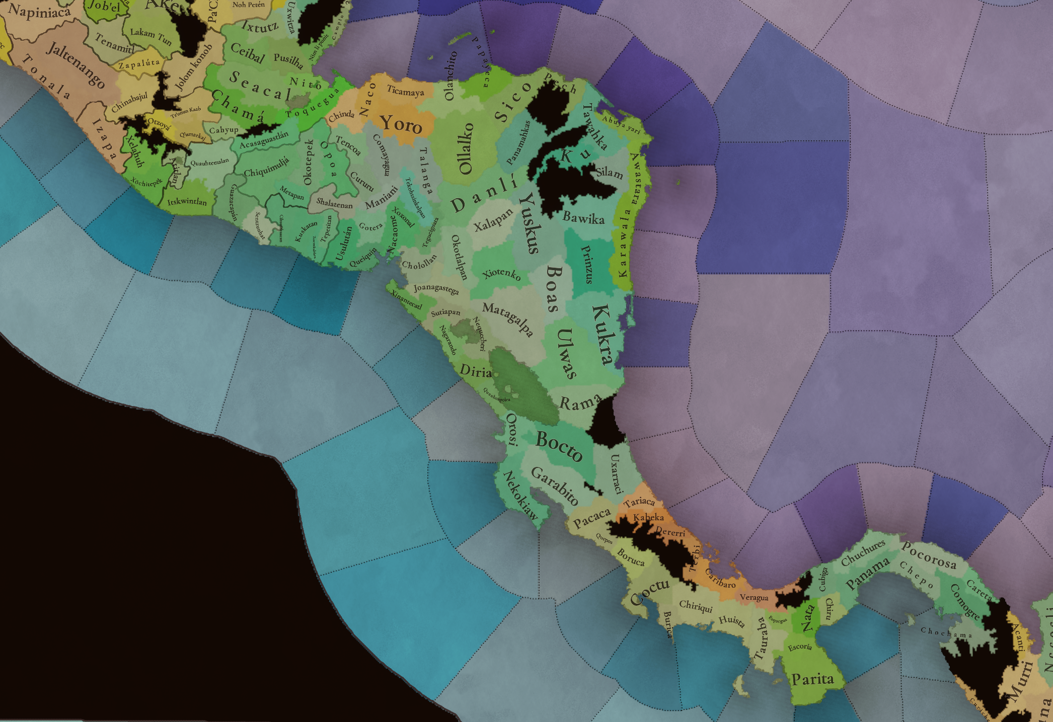
Hello everybody, and welcome to Tinto Maps, the happy Fridays for map lovers! Today, we will be looking at Central America, which includes the Caribbean. Before we start, I want to introduce you @RaulTrullenque , the only member of our Content Design team who had not yet gone public, and who worked really hard on the maps and content of the Central American and South American regions.

And now let’s get started without further ado!

Countries
Countries1.png

Countries2.png

Countries3.png

Countries4.png

Countries5.png

Countries6.png

Countries7.png

Tenochtitlan.png

Mayan.png
Welcome to the Mesoamerican Thunder Dome! This area is characterized by its numerous Altepetl, more or less comparable to city-states. Most of them are ruled in 1337 by peoples of Nahua origin, something that you may see much more clearly in the culture map. The biggest power in this moment is the Empire of P’urhépecherio, though, founded by the Purepecha people. In any case, you may notice that there’s a lot of detail in this area, including a tiny Nahua settlement recently founded on an island over Lake Texcoco, Tenochtitlan. This is the first time in a PDX GSG that we have the island itself present on the map, although the location covers some more land over the lake coast, to make it playable. Finally, we also have the Mayan polities of the Postclassic Period, of which Cocom, with its capital Màayapáan, was the most important, along with others, such as K’iche’ and its capital Q’umarkaj.

SoPs
SoPs1.png

SoPs2.png

SoPs3.png

SoPs4.png
On the outskirts of the Mesoamerican polities, there are plenty of peoples organized on different ways. To the north, we have the ones that populate the area known as Aridoamerica, which were collectively termed by the Nahua as ‘Chichimeca’. We also have plenty of societies close to the Mayan lands and the Isthmus. And, finally, the Taíno people populate some of the biggest islands in the Caribbean.

Locations
Locations1.png

Locations2.png

Locations3.png

Locations4.png

Locations5.png

Locations6.png

Locations7.png

Locations8.png

Plenty of locations here! I just want no note that the Darien Gap is an impassable wasteland, which means that any army trying to cross from modern Panama and Colombia will need transport ships to be able to do it.

Provinces
Provinces1.png

Provinces2.png


Areas
Areas1.png

Areas2.png


Terrain
Climate.png

Climate2.png

Topography.png

Vegetation.png

Vegetation2.png

A very diverse region! Most of it is covered by Tropical Jungles and Forests, but Sierra Madre Occidental and Oriental make for very specific conditions in the Mexican Altiplano, which are not only visible in the Topography map but also in the climate and vegetation of the area.

Development
Development2.png

The most developed regions in Mesoamerica are the Valley of Mexico and the Mayan coastline.

Natural Harbors
Harbors.png

There are some good ports in the Caribbean, no surprise that most of them would later become important cities in the Colonial Period.

Culture
Cultures.png

Cultures2.png

Tons of cultures!

Language
Dominant Languages1.png

Dominant Languages2.png

Court Language.png

And also languages! The first two maps are the Dominant Languages per location, while the third is the Court Languages one. The dark blue language is ‘Totozoquean’, as it is not so easily readable (something we have to change).

Religions
Religions.png

This map is today in a more advanced state, as we have merged plenty of cultural religions into regional groupings. Of these, Tonalism, Nahua, and Mayan are part of the Tonalist religious groups, while the others are part of the Folk American group (a regional split of the former ‘Animist’ group). Nahua and Mayan have their different mechanics, which we’ll talk about in future Tinto Talks. Let us know what do you think of this design and any suggestions about the religious grouping!

Raw Materials
Raw Materials1.png

Raw Materials2.png

Raw Materials3.png

Raw Materials4.png

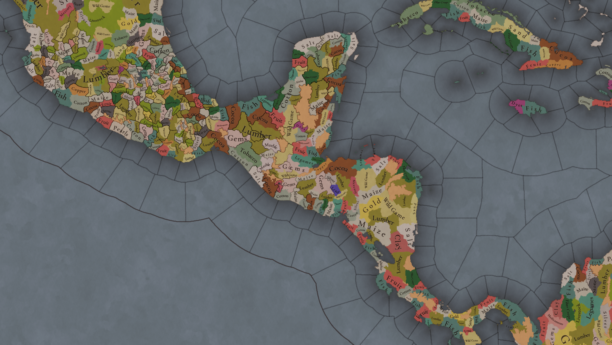
Maize is king in Mesoamerica, although there are plenty of other resources, including juicy Gold and Silver. Obsidian is not a separate resource, as it’s too regional-specific, so it’s included under the Gem coverage, but we have ways to represent it in-game; for instance, there’s a production method to produce Weaponry using Gems as an input.

Markets
Markets.png

A couple of bugs were reported while taking the screenshot of this map! But well, you can see that Azcapotzalco, Màayapáan, and Noh Petén (capital of the Itza people) are the most important ones.

Population
Population1.png

Population2.png

Population3.png

Population4.png

Population5.png

Population6.png

Population7.png

We have solved a couple of issues with the pop editor, and this week this map is in a decent state to be shown! Yay! Total numbers in the region are roughly 8.6M pops, distributed this way:
  • 523K in Aridoamerica (includes the lands to the North-West of the Purepecha Empire)
  • 6.947M in Mesoamerica (including North-Western Mayan lands)
  • 1.003M in Central America (including South-Eastern Mayan lands)
  • 151K in the Caribbean Islands

And that’s all for today! We hope you enjoyed these meaty maps! Next week we will be taking a look at the Levant Feedback, on Monday 16th, and South America, on Friday 20th! Cheers!
 
  • 112Like
  • 95Love
  • 5
  • 1
Reactions:
Tlacopan should definitely be added, make Valley of Mexico denser but add it!!

Otherwise forming triple alliance will really be bland experience without one of its member lol
 
  • 16
  • 4Like
Reactions:
I think there are too many raw materials that use a white/greyish colours, making it difficult to easily distinguish them. Especially here in Mesoamerica where there are a lot next to each other. These six are very similiar in colour: Maize, Gems, Silver, Marble, Pearls, Salt and maybe even Cotton.
I realise these colours fit the raw materials, but making them slightly more distinct from each other might help map readability. For example: Maize could be made a more yellow colour.
 
  • 10Like
  • 1Love
Reactions:
Definitely think that the Taino should be not just split up into 5 separate polities but bumped up from SoP's to Settled Countries. I am convinced.

Anyway, throwing my hat in the ring in favor of a separate Vanilla spice from Cocoa, and also think we should get peppers represented.
 
  • 13Like
  • 2
Reactions:
I’d like to suggest changing the name of the Purepecha Empire to ‘Irechikwa’ which appears to have been the states endonym. Alongside being the endonym, it also sounds really nice, rolls off the tongue.
 
  • 6Like
  • 1
Reactions:
Alright, let's see how a Panamanian that barely knows a thing about his very own country can do. Doing some research at the last minute as I write this.

Locations Map:

I would have said that Panama should be split in two at the Rio Grande (the river that was there before the pacific section of the Panama canal was built on top of it), but looking at the relief map from 1857, it was quite small and seemingly easily crossed when compared to its horrible and infamous neighbor to the north (the Chagres River). Here's an associated relief map from the Library of Congress for reference: item 92685992 (Sorry, can't post links!)

Basically, I can't think up on any changes here.

Areas

I like it. There was a whole fight about who got who after independence and today's borders are an (American enforced) compromise. The borders as shown there are roughly what both countries claimed.

Climate

Everything's tropical, and I have no trouble with that, since you're not distinguishing from "wet" tropical and "dry tropical" (reason as to why most of the population lives south of the central mountain range)

Topography

This is backwards. Chiriqui should be dominated by plains, and Burica should be hills. I was about to include Coctu as also plains until I saw that it's a big location that I confused it with it just being Coto. The lands surrounding Coto in Coctu are dominated by plains, just like Chiriqui. Maybe move the Chiriqui border to include these plains? I swear I do not hold any bias as a Panamanian and having studied a war between Costa Rica and Panama that was explicitly about this area I swear.
1734104556196.png

1734104606920.png


This region of Panama is a hard one, since most of the populated areas are in plains, though the location set up makes it a bit difficult to set the plains in the first place. I see that that it's why the Escoria location exists, to at least make an attempt to represent these plains, though it does leave out the plains that should be in the locations of Nata and Parita. Nata feels like it got the same treatment as Chiriqui, in which its most relevant territory is plains, but its getting caught up by the central mountain range that act as Panama's "spine" and set up as hills. I would argue that it should be set up as plains.

1734107191788.png


1734106207522.png


Parita, however, is a harder sell. Most of the territory in that location is hills with the exception of the strip of land on its eastern coast (consequently, its most populated section). Unless Parita is divided in two to complement Escoria (or even merged with it?), then it feels right for it to remain as hills.

1734107514310.png


And, of course, here's a relief map of all of Panama to get a better overall look at the situation here:
1734110194306.png


Vegetation

This one's difficult since huge sections of the country have basically been deforested to make way for agriculture, especially in the southern part of the country. So, I will just leave it out.

Culture Map Mode

I would say that the Veraguas region (outlined) should be inhabited by the Dorasque, a now extinct indigenous tribe. However, we don't know how much the Ngabe and the Dorasque overlapped in these regions of Panama, and we know that the both of them lived throughout all of western Panama, even past the outlined area. So I say that they should be added there, in the outlined area, to represent them. I think there's even a debate whether Urraca, a cacique (chief) who rebelled against the Spanish, was Ngabe or Dorasque since he ruled in the area where the Dorasque inhabited. The ngabe claim him as their own but we don't know for certain if that's true or if they're appropiating him. All of this said, I also believe that these two tribes should be SOPs, since they did manage to organize themselves to fight against the Spanish.

I believe there should also be some Ngabe pops in Bocas del Toro (where the Naso are)
1734103089271.png


Remove the Guna from the northern coastal section of the country. As far as I know, they migrated there AFTER the Spanish arrived and the reason they migrated there in the first place was a combination of the Spanish being the Spanish and the other tribes in the area encroaching on their territory. There's already Guna in the Colombian section on your map, so that tracks. That's them and that's where they should be at the beginning of the game. I wouldn't even know what to replace them with, however. That section of Panama was notoriously inhospitable, with multiple failed attempts from both the Spanish and the Scottish. When the Guna migrated there, they only settled the islands in the coast because of how horrible the conditions were in the mainland.

Trade Goods

Once more, this part is difficult to me, and thus I can't really comment on it unfortunately.

Also, THANK YOU for adding the Darien Gap!

EDIT

Just in case the post that I made on population slips through the cracks, since this one is receiving the bulk of the attention.

The population numbers blindsided me and I didn't take them into consideration when making my posts on Panama. Right now, the isthmus in the game has around 48k people, while historians (Alfredo Castillero C. 1995) place the population of the indigenous in the isthmus to have been at least 150k to 250k before the arrival of the Spanish. (A historian in 1853, Fernández de Oviedo, said 2 million but I personally don't believe that to be possible.) They were mostly centered around the pacific coast of the country.
 
Last edited:
  • 16Like
  • 3
  • 2
  • 1Love
Reactions:
I hope Tlaxcala will be super hard to conquer unlike eu4 lol,
maybe make Tlaxcala confederacy IO, which would be formed shortly after 1337,(which had 4 tags in) and it similar to Switzerland cantons having IO, it can be a defensive alliance and some decisions in IO menu which can be used to get buffs during defensive war
 
  • 11Like
Reactions:
Are Saba and St. Eustatius a single or different locations ? I never thought you guys would actually depict these small islands!
 
I think, Tenochtitlan should be a island location in lake Texcoco, and Lake Texcoco should be a one sea tile travarseble by navies.
This would be really cool. And would provide unique flavour to this region. I understand devs aren't for it as it isnt consistent with other choices in the map, but who cares about consistency that much. Give us interesting gameplay ie this and venice island!
 
  • 4
  • 1
Reactions:
This would be really cool. And would provide unique flavour to this region. I understand devs aren't for it as it isnt consistent with other choices in the map, but who cares about consistency that much. Give us interesting gameplay ie this and venice island!
Actually making Tenochtitlan not a island location will create the inconsistency,

as it was announced in Italy feedback that Venice (which is similar to situation in Tenochtitlan and Hormuz, but its in Europe :p ) is planned to be represented as island city or something flavourful like it instead of a location modifier which seems rushed partial solution and it is impossible to represent naval requirement of sieging island city
 
  • 7Like
  • 2
Reactions:
I think, Tenochtitlan should be a island location in lake Texcoco, and Lake Texcoco should be a one sea tile travarseble by navies (Like Caspian Sea and Great Lakes), this will make Tenochtitlan look and act like island capital and in order to take it you have to occupy nearby locations, build a navy, destroy the Aztec Canoes in lake then siege the city as this was how it happened historically

!(Spanish built Brigantines in order to achieve naval superiority in lake, it should be pretty much impossible to conquer Tenochtitlan without having a navy in lake


About how to implement this, I think the similar system that will be used in Venice and Hormuz can be used to represent Tenochtitlan as a location in lake

Otherwise Aztecs will lose the one of the most unique flavour they got similar to Venice imagine if Venice is land location (right now it is but it is said to be changed)


I mean right now Tenochtitlan looks like it is super vulnarable and has no chance of using its historical flavour as a island city in lake
I like this idea a lot, though it would require enlarging the island. Which unlike Venice is much less constrained by the size of the body of water surrounding it. I'd also love to be able to make use of the naval control mechanics around Lake Texcoco, as I suspect standard lakes don't project control in the same manner. Given the shape of Lake Texcoco, it could conceivably be split into two sea tiles.
 
Last edited:
  • 3
  • 1
Reactions:
Actually making Tenochtitlan not a island location will create the inconsistency,

as it was announced in Italy feedback that Venice (which is similar to situation in Tenochtitlan and Hormuz, but its in Europe :p ) is planned to be represented as island city or something flavourful like it instead of a location modifier which seems rushed partial solution and it is impossible to represent naval requirement of sieging island city
Yeah tbh I don't want to get into the political stuff and all, but simply put I think the idea of having to build a fleet from scratch to try and seize a city is really cool gameplay. That's the main reason I want it in. Don't know anything about Hormuz.
 
  • 1Like
Reactions:
Our map is detailed, but not as much as for having Tenochtilan as a one-island location. Maybe for Project Caesar 2: Electric Boogaloo!
I mean, I don't think most people would be adverse to just making Tenochtitlan's island artificially bigger to get it over the pixel threshold... it honestly doesn't even look too bad having it be a larger island. Having the Mexica controlling Tlacopan at the start date just feels wonky. Not only does not having Tenochtitlan being an island location make representing its defensibility harder, but it also makes accurately representing early Aztec history and the the Triple Alliance itself impossible. Maybe an expanded Tenochtitlan island could look something like this:
1734110964652.png


Especially considering the political situation at the start date would look something like this, with Azcapotzalco controlling all the lands to the West of Tenochtitlan.
1734111207341.png


Azcapotzalco would conquer Culhuacan in 1377 as well. With the current location setup, representing that would be impossible without having Azcapotzalco having strange-looking exclaves.
1734115133001.png


The region around Tenochtitlan island is mostly part of a larger archipelago anyways, all that would need to be done is artificially join it together into one larger island, and perhaps expand it a little more if necessary. Much of the area in between those islands was covered by chinampas as well, so the abstraction isn't too unwarranted.
1734112123643.png


All of that is not even mentioning that Tenochtitlan's island was artificially expanded by the Aztecs and the lake was heavily drained during colonial times anyways, so the Lake Texcoco wouldn't remain fully accurate for long in-game anyways, even if you didn't decide to expand Tenochtitlan's island.
1734116243580.png
 
Last edited:
  • 27Like
  • 10
  • 6
  • 3Love
  • 1
Reactions:
I’m surprised where modern day Veracruz is located is not as good a harbor as all the others. Usually when you think of Mexico you think of that port. I’m not super familiar but shouldn’t it be better?
 
  • 3
  • 1Like
Reactions:
Will there`s a mechenic to reflect the Aztec Triad and other leagues like Tlaxcala, and separate them?
Also, is there a mechanic to enhance the game experience of those who plays Tenochtitlan, as in early game and real history the city was just built decades ago, and finally beating the older ones to get the leader status of the Triad?
 
  • 1Like
Reactions:
I think there's room in the game for Chili/Vanilla if we have Dates as a Resource.

Speaking of room, is it really impossible to add Tenochtitlan as an enlarged island?
 
Last edited:
  • 10
  • 1Love
Reactions:
As an actual native yucatec mayan I want to first say thanks for showing a better representation than in previous titles, I am really excited to try out playing in this region when this game comes out.

I just hope there is more names on the namelists for the cultures than there was on games like EU4 and Victoria 3 xP
 
  • 6Like
Reactions: