• We have updated our Community Code of Conduct. Please read through the new rules for the forum that are an integral part of Paradox Interactive’s User Agreement.

Tinto Maps #29 - 13th of December 2024 - Central America

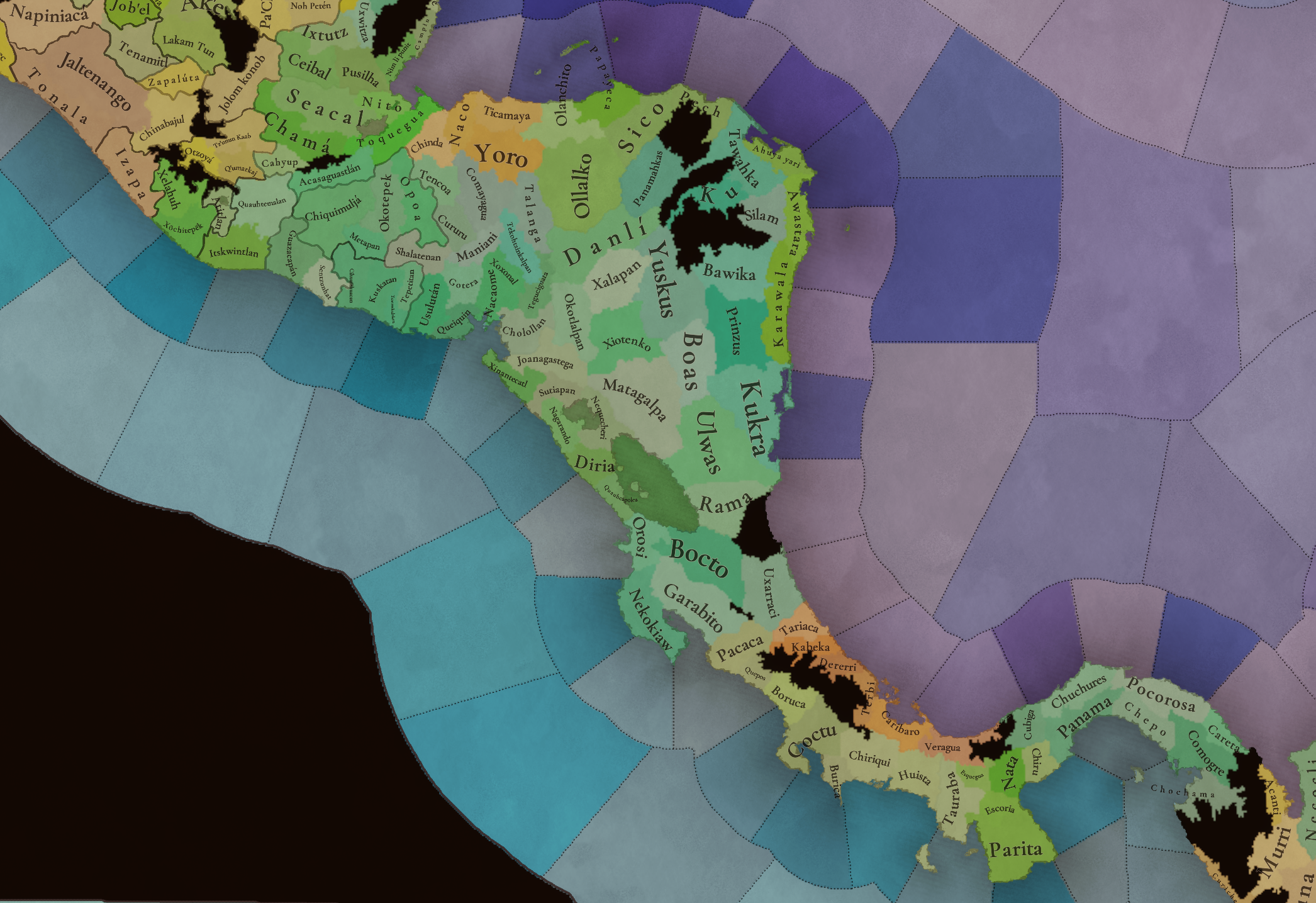
Hello everybody, and welcome to Tinto Maps, the happy Fridays for map lovers! Today, we will be looking at Central America, which includes the Caribbean. Before we start, I want to introduce you @RaulTrullenque , the only member of our Content Design team who had not yet gone public, and who worked really hard on the maps and content of the Central American and South American regions.

And now let’s get started without further ado!

Countries
Countries1.png

Countries2.png

Countries3.png

Countries4.png

Countries5.png

Countries6.png

Countries7.png

Tenochtitlan.png

Mayan.png
Welcome to the Mesoamerican Thunder Dome! This area is characterized by its numerous Altepetl, more or less comparable to city-states. Most of them are ruled in 1337 by peoples of Nahua origin, something that you may see much more clearly in the culture map. The biggest power in this moment is the Empire of P’urhépecherio, though, founded by the Purepecha people. In any case, you may notice that there’s a lot of detail in this area, including a tiny Nahua settlement recently founded on an island over Lake Texcoco, Tenochtitlan. This is the first time in a PDX GSG that we have the island itself present on the map, although the location covers some more land over the lake coast, to make it playable. Finally, we also have the Mayan polities of the Postclassic Period, of which Cocom, with its capital Màayapáan, was the most important, along with others, such as K’iche’ and its capital Q’umarkaj.

SoPs
SoPs1.png

SoPs2.png

SoPs3.png

SoPs4.png
On the outskirts of the Mesoamerican polities, there are plenty of peoples organized on different ways. To the north, we have the ones that populate the area known as Aridoamerica, which were collectively termed by the Nahua as ‘Chichimeca’. We also have plenty of societies close to the Mayan lands and the Isthmus. And, finally, the Taíno people populate some of the biggest islands in the Caribbean.

Locations
Locations1.png

Locations2.png

Locations3.png

Locations4.png

Locations5.png

Locations6.png

Locations7.png

Locations8.png

Plenty of locations here! I just want no note that the Darien Gap is an impassable wasteland, which means that any army trying to cross from modern Panama and Colombia will need transport ships to be able to do it.

Provinces
Provinces1.png

Provinces2.png


Areas
Areas1.png

Areas2.png


Terrain
Climate.png

Climate2.png

Topography.png

Vegetation.png

Vegetation2.png

A very diverse region! Most of it is covered by Tropical Jungles and Forests, but Sierra Madre Occidental and Oriental make for very specific conditions in the Mexican Altiplano, which are not only visible in the Topography map but also in the climate and vegetation of the area.

Development
Development2.png

The most developed regions in Mesoamerica are the Valley of Mexico and the Mayan coastline.

Natural Harbors
Harbors.png

There are some good ports in the Caribbean, no surprise that most of them would later become important cities in the Colonial Period.

Culture
Cultures.png

Cultures2.png

Tons of cultures!

Language
Dominant Languages1.png

Dominant Languages2.png

Court Language.png

And also languages! The first two maps are the Dominant Languages per location, while the third is the Court Languages one. The dark blue language is ‘Totozoquean’, as it is not so easily readable (something we have to change).

Religions
Religions.png

This map is today in a more advanced state, as we have merged plenty of cultural religions into regional groupings. Of these, Tonalism, Nahua, and Mayan are part of the Tonalist religious groups, while the others are part of the Folk American group (a regional split of the former ‘Animist’ group). Nahua and Mayan have their different mechanics, which we’ll talk about in future Tinto Talks. Let us know what do you think of this design and any suggestions about the religious grouping!

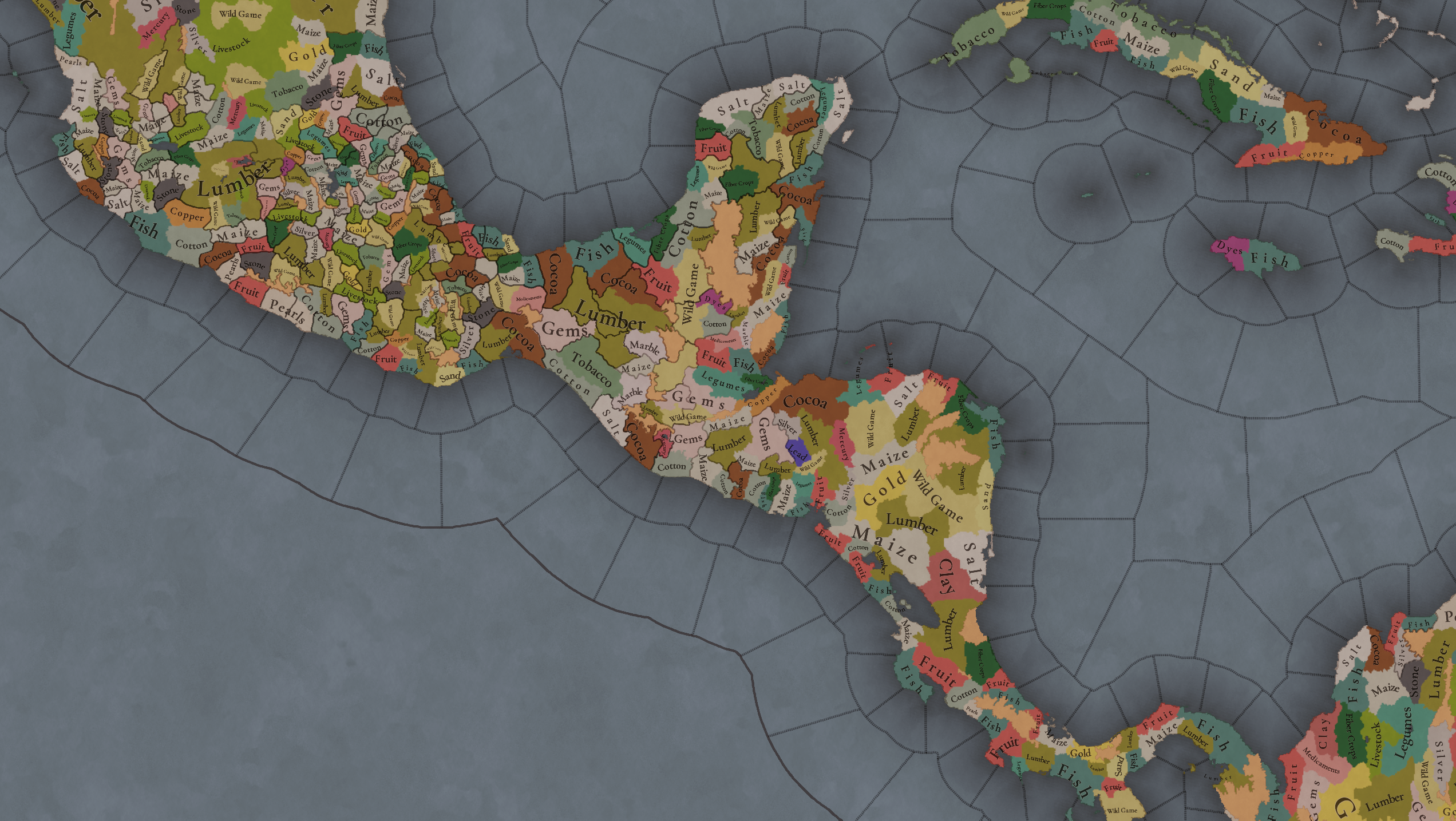
Raw Materials
Raw Materials1.png

Raw Materials2.png

Raw Materials3.png

Raw Materials4.png

Maize is king in Mesoamerica, although there are plenty of other resources, including juicy Gold and Silver. Obsidian is not a separate resource, as it’s too regional-specific, so it’s included under the Gem coverage, but we have ways to represent it in-game; for instance, there’s a production method to produce Weaponry using Gems as an input.

Markets
Markets.png

A couple of bugs were reported while taking the screenshot of this map! But well, you can see that Azcapotzalco, Màayapáan, and Noh Petén (capital of the Itza people) are the most important ones.

Population
Population1.png

Population2.png

Population3.png

Population4.png

Population5.png

Population6.png

Population7.png

We have solved a couple of issues with the pop editor, and this week this map is in a decent state to be shown! Yay! Total numbers in the region are roughly 8.6M pops, distributed this way:
  • 523K in Aridoamerica (includes the lands to the North-West of the Purepecha Empire)
  • 6.947M in Mesoamerica (including North-Western Mayan lands)
  • 1.003M in Central America (including South-Eastern Mayan lands)
  • 151K in the Caribbean Islands

And that’s all for today! We hope you enjoyed these meaty maps! Next week we will be taking a look at the Levant Feedback, on Monday 16th, and South America, on Friday 20th! Cheers!
 
  • 117Like
  • 95Love
  • 5
  • 1
Reactions:
Good to see this region finally!

A few questions and comments mostly from PR:

Since we have three provinces there naming should go like this
Boriken- Puerto Rico
Guaynabo- San Juan
Arasibo- Arecibo
Guaynia- Should Switch to Ponce

Terrain and Vegetation are correct.

1. San Juan doesn't seem to be a max level natural harbor, which is weird. There's a reason Spain built the biggest fort there and not Havana which was always more important economically. The bay was better for sail boats was better protected both from storms and piracy as it was more easily defended.

2. Instead of Maize in PR that region Guaynia was known for producing sea salt.
3. Any additional modifiers we haven't seen yet?
Added most of these suggestions, although I've used 'Guaynía' as the Spanish version of Guaynia, as that was the name of the first settlement founded by Ponce de León before it was destroyed.
 
  • 16Like
Reactions:
Mesoamerica is home to two of the most important spices in the world, vanilla and chilis, and neither is represented. Vanilla was mostly used to flavor chocolate for the first half of the time period, but by the end of the game it was a hugely valuable spice. Chilis are one of the most successful parts of the Colombian Exchange as well - almost every old world culture adopted and began to use chilis in their cuisine as a spice.

It seems ridiculous to ignore that impact on global trade and cuisine entirely. I'll direct attention to this excellent post by @LordThanatos with some amazing discussions and deep dives into spice production and usage across the world and the time period.
We have this post tracked because it's excellent, I agree with that. We'll adjust as many resources as possible, considering it.
 
  • 24Love
  • 13Like
  • 3
Reactions:
Once again, great job.

I'd like present two more questions/suggestions (me as a simple lover of this Island-Nation):

1) location 19 - North Camaguey looks a tad big, long and snakey. Are there any grounds (geographical, demographical, economical, etc.) to split it up in two locs?

2) Do you place Havana's harbor at the same level as Cienfuegos, Santiago and Guantanamo? I don't know, I may be letting my historical bias shine through, but Havana has imo one of the best natural harbors in the world (...and it "held the keys" to the Gulf of Mexico).

I'm glad to answer.

1) Camaguey as a whole region is, in comparison with other regions of Cuba, the least dense region, and with the exception of the city of Camaguey, the entire province in real life and historically was a long plain field perfect for cattle and horses. Thats why I suggest leaving the North Camaguey (19) province long. The most important town and the oldest of the province is the port town of Nuevitas, which was the original settlement of Puerto Principe (one of the seven initial settlements) before the Spanish decided to move the settlement inland, to the actual location of the city of Camaguey. Also, during the first Cuban Independence War, the condition of the province of Camaguey (very sparse population, very few settlements, very long plain fields) made possible the formation of a very effective cavalry army lead by Ignacio Agramonte, one of the most important figures who fought for the Cuban independence.

2) The reason why I place Havana's harbor as the same as the other three is because, from a naval point of view, those four were, and still are, the best bays and natural harbors of Cuba. The reason why Havana's harbor developed quickly and outpaced the rest was due to its strategic possition. For the Spanish Treasure Fleet, it was easier stop in Havana before they sailed to Spain, and when they sailed to Spain, they could use the gulf current to navigate with ease. But the other bays are really good also. Santiago's Bay is too easy to defend and is very safe for the ships. At the beginning, this was the reason behind making Santiago the capital of Cuba during the colonial period, but the mountains and the earthquakes made dificult to develop Santiago. The Jagua Bay, or Cienfuegos Bay, is very big and deep, and easy to defend, and that without mentioning is very calm. The Guantanamo Bay also is very calm and easy to defend, and there is a little valley nearby the bay, where the port town of Caimaneras is now-a-days. The real problem of Santiago, Guantanamo and Cienfuegos was its geographical possition to the south, wich made them unnatractive for the Spanish Treasure Fleet.
 
  • 1
Reactions:
In the Nahua culture and religion, feathers, especially those from the Quetzal bird, were considered to be very important. Feathers were used to create ceremonial clothing, shields, tapestries and other works of art. Also, feather-workers were considered to be amongst the most respected artisans. Similarly to obsidian, this good is too localized to the americas to have it as a separate resource but I think it would add great flavor to have Wild Game as an input for luxury goods within the region.
It sounds as a great idea to create another PM for Wild Game to be used in Luxury Clothing, bookmarking this as well.
 
  • 19Like
  • 9Love
Reactions:
Added most of these suggestions, although I've used 'Guaynía' as the Spanish version of Guaynia, as that was the name of the first settlement founded by Ponce de León before it was destroyed
Thank you for your reply!

1. As to naming:
The Taino names are OK, the dynamic name should be that if they are colonized by Spain. There were too many small cacicazgos in the area to represent within the scope of the game so those that are included are a good fit.
As to Guaynia, that was the largest Cacicazgo under Agüeybana, the Spanish however built a temporary settlement in the area before moving to Caparra (in present day Guaynabo) and then later to San Juan.

Guaynia later became modern Guayanilla but during the scope of the game that settlement was (and still is) minor in comparison to Ponce and Mayaguez on the Southern and western coast of PR respectively.

Trade goods of fish and salt are OK. Maybe stone where there is fruit? (the island was always more important as a bastion rather than economically because of the hilly terrain especially when compared to Cuba and Hispaniola)

Anyway I'm happy to see multiple locations even for small islands because it allows for multiple avenues of expansion and trade.
 
- Will there be special situations in the Caribbean, regarding colonial competition, piracy ?

- Will there be specific mechanics to prevent colonization, raid other colonies or steal colonial trading posts without the countries being formally at war as in reality ?

- Will we see Captain Jack Sparrow ? :cool:
Oh, yes, we will have Pirates!
 
  • 12Love
  • 7Like
Reactions:
Are Saba and St. Eustatius a single or different locations ? I never thought you guys would actually depict these small islands!
They aren't separate locations, I think they may end up being part of the same location as Saint Kitts and Nevis.
 
  • 6Like
  • 2
Reactions:
It would be cool if the population maps would have a color gradient like the development map has. Perhaps use a subtle color so not to interfere with the numbers.
I think you would want the colors to represent population density instead of raw population. This it to handle the cases where the size of the locations are different.
 
  • 2Like
  • 2
Reactions:
San Juan doesn't seem to be a max level natural harbor, which is weird. There's a reason Spain built the biggest fort there and not Havana which was always more important economically. The bay was better for sail boats was better protected both from storms and piracy as it was more easily defended.

I do agree the biggest Spanish fort in the Caribbean was in San Juan, however I feel the need of point out that La Habana had five castles/forts (El Morro, La Punta, La Fuerza, El Principe, Atares), one fortress (La Cabaña), a wall, and at least seven coastal defensive towers. May PR have the biggest fort, but Havana had the biggest defense sistem of the Caribbean Islands.
 
  • 1
Reactions:
It looks good. Clashes a bit with copper but I can sort that out.

View attachment 1231999

Also, thumbs up for using HSV like a good one.
What about some saturated turquoise like HSV 180, 100%, 90% for gems? It's one good that could be virtually any vibrant colour and I also think it deserves to stand out, so this slightly pinkish off-white may not be very on-brand, even if pinkish white gems do exist

If someone looks at the raw good map, it would be a good idea if more "precious" resources stood out visually at first glance a bit more.
 
  • 3Like
  • 1
Reactions:
Awesome work, I love to see that there's lots of effort by the team to create an accurate North and South America. I am so excited to finally play in the region were I am from: Colombia.

I have lots of comments and suggestions for South America (I'm even working on a map with suggestions for the Colombia area) that I should probably save for the next Tinto Maps.

However, I do have some preliminary questions regarding the small bits we've already seen from South America.

A. Why do the Tayrona people do not speak the "Chibchan language"? The subgroups that evolved out of them (Wiwa, Kogi, Ijka and Kankuamo) are known to speak four different Chibchan languages. This makes it very likely that the Tayrona language was a Chibchan successor to these four Chibchan languages, rather than a language isolate.

B. Moreover, the Chimila Society of Pops should be named "Ette Ennaka" instead, considering that they find the use of the word "Chimila" rather offensive and it was a Spanish colonial exonym. For some reason, the culture of the Chimila Society of Pops is accurately places as "Ette Ennaka". I would suggest having the Society of Pop be named Ette Ennaka as well.

C. I think that the various Zenú chiefdoms along the Sinú river could be three separate Settled Countries, considering that they had centralised power structures and extensive work of "engineering" to control the flow of the various rivers in their region and avoid floods. They had relatively large settlements with big mounds, similar to those of the Mississippians at Cahokia. The Zenú could be split between the following three chiefdoms: Zenúfana, Panzenú and Finzenú.

D. The province and area borders look a bit weird, considering that the areas in North America are based on the colonial provinces and states. I would suggest splitting the Sinu and Suchiimma areas into three areas:

1. Sinu: covering all the current area but stopping at the Magdalena River. With these borders, it would emmulate the Zenú chiefdoms, as well as the Spanish Colonial Province of Cartagena.

2. Wajiira: covering everything east of the Magdalena River up to the Serranía del Perijá, including, of course, the Guajira Peninsula, its indigenous namesake. It would also roughly be similar to the Spanish Colonial Province of Santa Marta.

3. Suchiimma: The rest of the area, roughly corresponding to the Spanish Colonial Provinces of Maracaibo, Coro and New Mérida.

E. Regarding natural harbours, I believe Portobelo, in the Caribbean coast of Panama should also be some sort of strong harbour. It has a huge natural bay and it was one of the main colonial ports of Spain in the New World, everything they transported from Panama City to the Caribbean passed through Portobelo. Sadly, it lost its status after the city of Colon replaced it when the Panama Canal was built, hence why it isn't as popular as a shipping port in the present. (The forts to defend the port at Portobelo are even a UNESCO World Heritage Site). Santa Marta was also a mid-ranking harbour during the colonial era.

F. I would suggest adding the island location of Old Providence off the coast of Nicaragua. It was an important pirate heaven used by Henry Morgan to capture various Spanish colonial cities, as well as one of the first English Puritan colonies in the New World.

G. Why is there Tayrona culture on the eastern shore of Lake Maracaibo? What about Kalinago culture in the middle of Colombia?

That's it for now, I will be saving the rest of my suggestions for the proper South America Tinto Map.

As I already mentioned, awesome work!
Please repost all the Colombian-related suggestions in the South American Tinto Maps. ;)
 
  • 13Like
Reactions:
Something I've been wondering if it could be changed is the population numbers for the Americas, including Mesoamerica as showcase in this Tinto Maps. I feel like the numbers used are on a very conservative low-end for pre-Columbian population estimates, so I kinda wonder what sources are being used to sustain these numbers.

"American Holocaust: The Conquest of the New World" proposes that as many as one hundred million natives died as a result of European diseases and colonization. While this exact number has been criticised, it is part of a pattern of scholarly publications going for higher numbers than the ones currently being used.

"La catastrophe démographique" proposes that Mexico, Central America, and South America had a combined population of 37 million, of which 6 were in the Aztec Empire, 5 to 10 million were on the Mayan States, 11 million in modern Brazil, and 12 million in the Inca Empire. This alone could substantially raise population numbers for Mesoamerica and South America.

"American Indian Holocaust and Survival: A Population History Since 1492" compiles many population estimates for North America, ranging from as low as 1 million to as high as 18 million. A more reasonable range, as given by the book itself, is between 1.5 million and 12 million, with arguments given to defend both ends of the range.

Recent studies regarding the Amazon rainforest, done within the last two decades, usually put the Amazon at a range of between 6 to 10 million, with usual agreement on the lower end of the range between 6 to 8 million. The reason for this number is the extensive evidence of settlements across the Amazon river basin prior to European Colonization but also during it. Early European accounts of the region show a patchwork of cities, large villages, and road networks in a complex civilization.

To conclude my point, I don't think it would be incorrect to say that the numbers given by Paradox (~20 million for the whole continent) are low, very much so. Personally I think it could be increased between two to three times, in a range of between 40 to 70 million. If I had to choose an arbitrary number, I'd go with about 64 to 66 million, for a variety of reasons such as better showcasing the absolutely apocalyptic scale of the arrival of Europeans and the devastation they caused directly and indirectly.

@Pavía
 
  • 9Like
  • 4
  • 2
Reactions:
You can absolutely fit all three. Tenochtitlan doesn’t need to extend that far north, cut it in half and give the new area to Talacopan, with Azcapotzalco being tweaked so their southern border is midway between the cities of Azcapotzalco and Talacopan
I've been discussing this with the team, I think that we might potentially take some room from Cuauhtitlan in the north for Azcapotzalco, and then try to squeeze Tlacopan between Azcapotzalco and Tenochtitlan, also take some pixels from the later... But no promise about it until we start the map review.
 
  • 18Love
  • 12Like
  • 4
  • 2
Reactions: