• We have updated our Community Code of Conduct. Please read through the new rules for the forum that are an integral part of Paradox Interactive’s User Agreement.

Tinto Maps #6 - 14th of June 2024 - Great Britain & Ireland

Hello everyone. @Pavía and the rest of the Content Design team are busy working on the feedback for the previous Tinto Maps, so I'm standing in for this week.

I'm @SaintDaveUK, some of you might have seen me here and there on the forums, but the long story short is that I work on a very secret game whose name I am contractually obligated to redact. That's right, it's ███████ ██████!

This week you get a double-whammy, mostly because it’s really hard to show Britain on its own on a screenshot. Partly to side-step the “British Isles” naming controversy, but mainly because the gameplay of them both is so different, this part of Europa is divided into 2 distinct regions: Great Britain and Ireland.

Climate​

The mild Oceanic climate (Köppen Cfb) dominates the isles. Where it cools towards the inland Pennines and the Scottish Highlands (Köppen Cfc), we represent it with the wintry and dreich Continental climate.

climate.jpg


Topography​

The isles are dominated by green and pleasant flatlands and low rolling hills, the peripheries punctuated by rocky mountains and craggy highlands.

We would like to add some more impassable locations in northern England and the Scottish borders to make manoeuvres a little more interesting and strategic, but would like suggestions from people more familiar with the Pennines.

[Edit: 16 June added the missing map]

topography.JPG


Vegetation​

The great moors, bogs, and fens are represented by Sparse vegetation, meanwhile much of the land is still wooded.

vegetation.jpg


Raw Materials​

The raw goods situation aims to reflect the economic reality of medieval Britain. Shepherding was common on every corner of the islands, a lot of the wool produced was sold to the industrial hub of the Low Countries to be manufactured into cloth, which was in turn sold back to British markets.

The further north-west we go, the less fertile the terrain, and as such the greater reliance on pastoral farming such as livestock over wheat. The western hills and valleys also expose a greater number of mineral delights, including the historic stannary mines of Devon and Cornwall.

raw_materials.jpg


Markets​

As you can see the two starting markets are London and Dublin. Aside from London we could have chosen almost any town, from Aberdeen to Bristol. We chose Dublin as it was the main trade centre in Ireland, and also because it handsomely splits the isles to the East and West of the Pennines, demonstrating the impact that terrain can have on dynamic Market attraction.

They are both shades of red because they are coloured after the market centre’s top overlord country – market control is a viable playstyle and we like to think of it as a form of map painting for countries not focused on traditional conquest routes.

market.jpg


Culture​

We have decided to go with a monolithic English culture. We could have forced the introduction of a second Northumbrian or even third Mercian culture, but typically they were not really considered separate peoples. The English, though diverse in origin and with a variety of dialects, had already begun to coalesce in the face of the Viking invasions hundreds of years before.

Scotland, conversely, is a real porridge of cultures. The Lowland Scots (who speak a dialect of Northumbrian English that later develops into the Scots language) dominate their kingdom from their wealthy burghs, and are gradually encroaching onto the pastoral lands of the Gaelic Highlanders. The Norse-Gaelic clansmen watch from the Western Isles, with some old settlements remaining around Galloway. The far north, ironically called Sutherland, retains some Norse presence.

Wales, conquered for around a century by this point, plays host to English burghers looking to make a few quid, as well as the descendants of Norman adventurer knights in the marcher lordships, but is still majority Welsh-speaking from Anglesey to Cardiff.

The Anglo-Irish (representing the spectrum from Cambro-Norman knights to the so-called ‘Old English’ settlers) live in great numbers in the south-eastern trading towns from Dublin to Cork, as well as in smaller numbers in frontier outposts.

The cosmopolitan towns across the isles are also home to people from elsewhere in Europe, most notably Flemish weavers from the Low Countries, though their numbers are too small to impact the mapmode.

The Norman ███████ dominates as the ██████████████ for both of the kingdoms and their subjects. The conquest of 1066 is no longer fresh, but the continuing bonds between the aristocratic classes of England, Scotland, and France have kept the French language alive and strong.

culture.jpg


Religion​

I decided that it's not even worth taking a screenshot of the Religion map mode. There are tiny minorities of Jewish people in some Scottish and Irish towns (they had been expelled from England), but they are so small in number they don't even register on the map mode

Other than that, it's all Catholic. But not for long.

> John Wycliffe has entered the chat.


Areas​

Based on the 4 provinces of Ireland (sorry Meath) and splitting England roughly into the larger Anglo-Saxon earldoms which have some similarity with the modern Regions (sorry Yorkshire).

areas.jpg


Provinces​

We have fixed the colours of the Provinces mapmode so you can see the individual provinces a bit more clearly. These are largely based on the historic counties, which have remained fairly constant throughout history, while merging some of those that are too small.

We’ve almost certainly offended someone.

The ancient Scottish shires are pretty messy and difficult to coalesce into neat provinces, so any suggestions for better arrangement there would be very welcome.

provinces.jpg


Locations​


You might notice that the locations in Ireland are varyingly written in both English and in Irish. This is because we have the new system up-and-running where we can name Locations by the primary culture of the country they are owned by.

This means that for example London might be called Londres if it was ruled by a Catalan country. It’s currently a WIP feature and we might add more elements, such as a game setting to base the name on dominant culture of the location instead, or to just use default (English) names.

locations.jpg


Government Types​

As with most of Europe, most of the countries are under some monarchy or another, but the Irish tuathas begin with the Tribe government type. This, among other mechanics such as [redacted] helps to give them a very unique playing style in Europe.

government.jpg


Countries​

England

England of course stands as the dominant kingdom in the isles. Despite having a lot of power resting on the barons, the country is fairly unitary even at this point, with very little practical separation between the crown’s power in somewhere like Kent versus Yorkshire. However there are notable exceptions.

The powerful Burgesses estate in the City of London enjoys ancient freedoms from royal power, while the king peers in from the Crown’s seat of power in neighbouring Westminster.

The County Palatine of Durham is not represented by a country, but buildings that give the Clergy Estate a huge amount of power in the locations it is present in. This also ties into political gameplay as a ██████████ ██████.

The newly created Duchy of Cornwall—the only duchy in England at the time—would also not be represented well by the Cornwall country, being a disparate set of manorial holdings that are ironically mostly in Devon. Cornwall of course exists as a releasable country though.

The Isle of Man is a little less certain. For now we have it as a subject of England. On paper it was a ‘kingdom’ awarded to William Montagu, the king’s favourite, however we aren’t sure if he actually wielded any real power on the isle. It changed hands between England and Scotland numerous times in this period, but in practice it appears to have been governed by a local council of barons. Any more details on exactly what was going on here in this period would be greatly appreciated.

These decisions have been made because as England heaves itself out of the feudal system, we thought it would be best if the small-fry inward-looking internal politicking is handled through the Estates and [redacted] systems, and then the diplomacy tracks are freed up for the English player to behave more outwardly against other major countries.

Wales

Though subjugated by conquest, Wales was not formally annexed into the Kingdom of England until the mid 1500s. As such the principality begins as a Dominion subject under England.

Those familiar with Welsh history will note that historically the Principality of Wales didn’t extend much beyond the old kingdom of Gywnedd. Much of the country to the southeast was in fact ruled by marcher lords, which we represent with a powerful Nobility estate in the valleys and beyond.

There is an alternative vision of Wales that I would like to gauge opinion on, and that is expanding it to include the Earldom of Chester and the marches on the English side of the modern border. If you are an Englishman familiar with modern borders this might look alarming, but these lands were also constitutionally ambiguous parts of the “Welsh Marches” until the 1500s. This will hand over to the Wales player the full responsibility of dealing with the marcher lords, allowing England to focus on bigger picture issues like beating France.

Ireland

Ireland is going through a moment of change. English royal power is centred on the Lordship of the Pale, the king’s Dominion ruling out of Dublin Castle. However, it struggles to keep a grasp on the rebellious Hiberno-Norman earls scattered around the island - some of whom remain as vassals, some of whom have managed to slip free of royal control.

The Tanistry system of succession endemic to the Gaelic Irish has its advantages, but it can also lead to chaotic feuds between rival branches. The so-called Burke Civil War has fractured the powerful Earldom of Ulster into rival Burke cousins who jealously feud over their shrinking lordships in Connaught. Native Irish princes of the north have reconquered most of their own lands from the de Burghs, but there are also two rival O’Neill cousins who style themselves King of Tyrone either side of the River Bann.

The feuding Irish lack a unifying figure, but anyone powerful enough could theoretically claim the title of High King. The former provincial kingdoms, such as Meath and Connacht, enjoy the elevated rank of Duchy, giving them a slight edge in the High Kingship selection.

Scotland

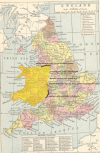
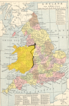
The chancer Edward Balliol continues his attempt for the Scottish throne, with England’s tacit permission. It’s hard to determine the exact lands held by Balliol in 1337, but we know his disinherited loyalists hold the castle of Perth while his English allies had seized large tracts of the lowlands from Bruce. Balliol has also bought the loyalty of the MacDonald and the other Hebridean galley lords by granting them remote land on the west coast of the mainland.

Meanwhile, Scotland’s canny regent Sir Andrew de Moray launches his decisive counterattack as his true king, David II de Bruce, waits in exile in France.

political.jpg


Dynasties​

We know about Plantagenet, Balliol, and Bruce, so I've zoomed in on Ireland to show the ruling dynasties of the various chieftains and earls.

dynasty.jpg


Population​

Excuse the seams and the greyscale mapmode. We have something better in the pipeline...

population_country.jpg
population_location.jpg


Well, thats it for now!

As always the team is eagerly awaiting your feedback and looking forward to the discussions. We’ll try to keep on top of the thread, but we have a teambuilding activity this afternoon so it might be a little more sporadic than usual!

Next week: Anatolia!
 
Last edited:
  • 218Like
  • 99Love
  • 7
  • 7
  • 1
Reactions:
FWIW, I'm also happy if peoples views are that there isnt enough of a difference between the various regional dialects, my impression from earlier in the thread was that this was not the case.

Also worth saying as I said when I did my GB map, this was assuming there was some kind of "cultural acceptance" mechanic so that you could model how similar each culture was.

Anyway, revised culture map without the further breakdown of irish and english:

1721824257556.png
 
  • 4Like
  • 4
  • 1
Reactions:
For the Scottish provinces I'd suggest renaming "Teviotdale" to the "Mairches/Marches". Maybe Lochaber and Ardtornish should be in Ross rather than Argyll? Kintyre could be given to Argyll in return as it fits better there than in the Inner Hebrides?
 
  • 3
Reactions:
FWIW, I'm also happy if peoples views are that there isnt enough of a difference between the various regional dialects, my impression from earlier in the thread was that this was not the case.

Also worth saying as I said when I did my GB map, this was assuming there was some kind of "cultural acceptance" mechanic so that you could model how similar each culture was.

Anyway, revised culture map without the further breakdown of irish and english:

View attachment 1167315
Every academic work I have read completely disagrees with your assessment of Welsh spread into now England. Sure those locations can be considered politically within the Welsh Marches, but culturally the only Welsh majority on the now England side of the border was in Clun Valley.
 
  • 2
  • 1Like
Reactions:
@WelshStalker I have already made a previous sourced comment on Welsh population and culture. If you have any sources or academic texts that suggest otherwise for the 1300s I would like to read them.
 
FWIW, I'm also happy if peoples views are that there isnt enough of a difference between the various regional dialects, my impression from earlier in the thread was that this was not the case.

Also worth saying as I said when I did my GB map, this was assuming there was some kind of "cultural acceptance" mechanic so that you could model how similar each culture was.

Anyway, revised culture map without the further breakdown of irish and english:

View attachment 1167315
I'd probably add Norn culture to Caithness

I still think it makes sense to separate it from Norwegian
 
  • 1Like
  • 1
Reactions:
@WelshStalker I have already made a previous sourced comment on Welsh population and culture. If you have any sources or academic texts that suggest otherwise for the 1300s I would like to read them.
Bit of a rude tone to take to a mere reaction reading 'respectfully disagree', but okay.
I agree that the spread displayed is a bit much, but the reality was that it was hard to tell what was Welsh and what was English due to a lack of information, but what can be gathered are snippets of what information could be inferred via administrative documentation.

I just wouldn't suggest a hard 100% one way or a 100% the other regarding nationality in the border regions, Oswestry, Clun and Archenfield were certainly more Welsh at the time of 1337 than they were English, with an argument to be made regarding a sizable minority in other regions of the marcher counties such as Chester but I've not personally found anything concrete. Nationality/language was far more fluid in the border regions and I disagree with a wholly Welsh or wholly English location, I believe areas should be interpreted as one way or another with sizeable majorities of the other wherever necessary as I had suggested last month.

1721957382642.png


Hereford - Sizeable by 15th century still:
"Charter evidence from Hereford indicates the presence of Welsh speakers amongst all classes of society, including the landowners who attended the shire court and even after the whole of Wales had been annexed by the English crown, Welsh-speaking gentlemen from the area continued to commission poetry in Welsh. The fifteenth-century poet Guto’r Glyn addressed a number of his poems to Henry Griffith, who lived at New court in the parish of Bacton. Since it was the duty of clergy to catechize and preach to the laity in their mother tongue, some proficiency in Welsh amongst clerics active in the Welsh borders was to be expected. (Putter, 2016)"

Putter, A., 2016. The linguistic repertoire of medieval England, 1100–1500. Imagining Medieval English, pp.126-144.

Shropshire - Dominant Welsh and Dominant English settlements as Well as Mixed:
"Some towns showed a mixture of people with English and those with Welsh names, such as Lydham and Lydbury North in Terra Episcopo. Other towns consisted entirely of people with Welsh or English names. In the Norman settlements of Hopesay and Clunungford on the eastern edge of the Honour of Clun, there were only English names in the Guild records. By contrast, the towns of Clun and Clunbury on the plateau of Clun provided only Welsh names to the Guild records. The Guild records thus strongly suggest that ethnic divisions still existed in the early sixteenth century in parts of the hinterland. (Bailey, 2020)"
Of note is that on Page 255 under figure 33, the percentage of Welsh names in Oswestry in the guild records stood at 80%, also notes that Glyndwr attacked into Oswestry too, burning a great deal of it down despite this Welsh population. ^
Bailey, J.L., 2020. Fleecing the Pious: the Palmers’ Guild of Ludlow in the Central and North Welsh Marches 1400-1530 (Doctoral dissertation).

More on Oswestry and Clun and why they were administratively English even if they were majority Welsh at the time:
Oswestry and Clun were only excluded from Welsh administrative lands because of petitioning by the Earl of Arundel who wanted his land unified within one legal jurisdiction, even though they were majority Welsh as per the above.
"There were two adjustments to the extent of jurisdiction of the Montgomeryshire Court of Great Sessions during the Tudor period. The first of these relates to the hundred of Clun, which was attached to the newly created county of Montgomery in 1536, in accordance with the provisions of the Acts of Union. For reasons unknown, the hundred of Clun was transferred to co. Salop on25 March 1546 by virtue of the Arundel Jointure Act of 1545. The transfer may simply have been on the grounds that the Earls of Arundel, who already possessed the hundred of Oswestry, which had been attached to co. Salop by the Acts of Union, wished to have all of their border property subject to the jurisdiction of one legal system"
Found here, document of the national library of Wales, Page 74: Life In Montgomeryshire During the Tudor and Stuart Periods

I don't disagree with the sentiment necessarily, just the wording and interpretation, it shouldn't be a fixed "one side is Welsh and the other is English" scenario like was suggested in the post you reacted to, but Welsh did certainly permeate that far with a decent chunk in Hereford town up until the 1700s too (though perhaps not in what is depicted as the location of Dean on that suggestion, I've not found much in the way of Welsh presence at the time in that area myself).
 
Last edited:
  • 4
  • 3Like
Reactions:
Every academic work I have read completely disagrees with your assessment of Welsh spread into now England. Sure those locations can be considered politically within the Welsh Marches, but culturally the only Welsh majority on the now England side of the border was in Clun Valley.
A lot of the regions I imagine you are contesting (Oswestry, South+West Hertfordshire) had only recently been conquered by the English in the last maybe 150 years. Without accurate sources I guess its hard to tell, if they are majority welsh, or just a sizeable minority, but there were definitely still a large welsh influence over those areas.

The province of Lydney in Gloucester admittedly might be a bit too far. I know Lydney and the area surrounding it had a lot of welsh influences (was part of the welsh kingdom of Eywas for a while etc.), but you're right that maybe saying it was majority Welsh is too far (especially considering how far the province extends up the severn).
 
Ok, so I may have gone a little more overboard, but following the updates for France I feel like GB deserves so more provinces (will leave Ireland to other experts). Most of these have been drawn using historic county, wapentake and hundred boundaries. The current map is also quite "blobby", and as a results seems more artificial than more natural wiggly borders that have been used in other regions. For context, this will be taking GB from 176 to 225 provinces, an increase of 50 provinces. Obviously I'd expect there are probably a few more for Ireland too, but it doesnt seem to crazy when France got 141 new provinces.

I've overlaid the province boundaries in red, with black denoting wastelands.

View attachment 1163790

I also propose a slightly tweaked start for Wales - the principality which is more autonomous and in a PU with England (and Welsh culture), and the Marches who are a vassal of England with English culture (or West Mercian - see below. I wouldnt include the border counties, as I understand it the marches were administered from there but control of those areas was administered centrally by the crown). England, Scotland and Balliol start as per the Tinto Talks
View attachment 1164273


Detailled breakdown of locations is below, colours denote the different provinces (note that some will have to be combined to work, honestly at the moment they are just based on the IRL counties)

ENGLAND
View attachment 1163791
1 - Penryn
2 - Truro
3 - Bodmin
4 - Launceston
5 - Plymouth
6 - Totnes
7 - Okehampton
8 - Barnstaple
9 - Tiverton
10 - Exeter

View attachment 1163796
1 - Taunton
2 - Wells
3 - Bath
4 - Glastonbury
5 - Yeovil
6 - Dorchester
7 - Wareham
8 - Shaftesbury
9 - Trowbridge
10 - Chippenham
11 - Marlborough
12 - Salisbury

View attachment 1163812
1 - Lymington
2 - Southampton
3 - Winchester
4 - Overton
5 - Portsmouth
6 - Wight
7 - Chichester
8 - Arundel
9 - Shoreham
10 - Lewes
11 - Hastings

View attachment 1163815
1 - Sandwich
2 - Hythe
3 - Ashford
4 - Canterbury
5 - Chatham
6 - Tonbridge
7 - Dartford
8 - Southwark
9 - Reigate
10 - Guilford
11 - Woking

View attachment 1163818
1 - London
2 - Westminster
3 - Windsor
4 - Reading
5 - Abingdon
6 - Banbury
7 - Oxford
8 - Henley
9 - Wycombe
10 - Aylesbury
11 - Buckingham

View attachment 1163819
1 - St Albans
2 - Hertford
3 - Hitchin
4 - Dunstable
5 - Bedford
6 - Huntingdon
7 - Cambridge
8 - Soham
9 - Ely

View attachment 1163828
1 - Waltham
2 - Prittlewell
3 - Chelmsford
4 - Dunmow
5 - Colchester
6 - Ipswich
7 - Sudbury
8 - Bury
9 - Eye
10 - Lowestoft
11 - Yarmouth
12 - Norfolk
13 - Fakenham
14 - Thetford
15 - Lynn

View attachment 1163834
1 - Towcester
2 - Northampton
3 - Peterborough
4 - Rutland
5 - Leicester
6 - Bosworth
7 - Harborough
8 - Coventry
9 - Birmingham
10 - Stratford

View attachment 1163836
1 - Bristol
2 - Gloucester
3 - Cirencester
4 - Tewkesbury
5 - Worcester
6 - Kidderminster
7 - Hereford
8 - Ewyas
9 - Kington
10 - Leominster

View attachment 1164233
1 - Clun
2 - Oswestry
3 - Ludlow
4 - Shrewsbury
5 - Wenlock
6 - Wolverhampton
7 - Stafford
8 - Leek
9 - Lichfield
10 - Nantwich
11 - Farndon
12 - Chester
13 - Halton
14 - Macclesfield

View attachment 1163847
1 - Derby
2 - Buxton
3 - Chesterfield
4 - Nottingham
5 - Retford
6 - Newark
7 - Grantham
8 - Sleaford
9 - Boston
10 - Louth
11 - Grimsby
12 - Lincoln

View attachment 1163849
1 - Hull
2 - Selby
3 - York
4 - Pocklington
5 - Bridlington
6 - Scarborough
7 - Whitby
8 - Thirsk
9 - Northallerton
10 - Richmond
11 - Skipton
12 - Ripon
13 - Leeds
14 - Pontefract
15 - Doncaster
16 - Sheffield
17 - Barnsley

View attachment 1163853
1 - Salford
2 - Warrington
3 - Liverpool
4 - Bolton
5 - Blackburn
6 - Preston
7 - Lancaster
8 - Barrow
9 - Kendall
10 - Appleby
11 - Penrith
12 - Egremont
13 - Carlisle

View attachment 1164232
1 - Stockton
2 - Darlington
3 - Durham
4 - Newcastle
5 - Hexham
6 - Wark
7 - Morpeth
8 - Alnwick

WALES

View attachment 1164217
1 - Monmouth
2 - Chepstow
3 - Cardiff
4 - Caerphilly
5 - Swansea
6 - Carmarthen
7 - Dinefwr
8 - Pembroke
9 - Fishguard
10 - Cardigan
11 - Aberystwyth

View attachment 1164224
1 - Brecon
2 - Bulith
3 - Radnor
4 - Montgomery
5 - Welshpool
6 - Corwen
7 - Harlech
8 - Caernarfon
9 - Anglesey
10 - Colwyn
11 - Chirk
12 - Wrexham
13 - Flint

SCOTLAND
View attachment 1164230
1 - Berwick
2 - Duns
3 - Dunbar
4 - Edinburgh
5 - Linlithgow
6 - Peebles
7 - Selkirk
8 - Kelso
9 - Hawick

View attachment 1164234
1 - Annan
2 - Dumfries
3 - Kircudbright
4 - Wigtown
5 - Maybole
6 - Ayr
7 - Irvine
8 - Renfrew
9 - Glasgow
10 - Lanark

View attachment 1164243
1 - Dunbarton
2 - Balfron
3 - Stirling
4 - Dumferline
5 - St Andrews
6 - Perth
7 - Aucterarder
8 - Dunblane
9 - Aberfeldy
10 - Dunkeld

View attachment 1164254
1 - Dundee
2 - Forfar
3 - Dunnottar
4 - Kildrummy
5 - Aberdeen
6 - Buchan
7 - Banff
8 - Elgin

View attachment 1164259
1 - Aran
2 - Tarbert
3 - Islay
4 - Inveraray
5 - Dunoon
6 - Oban
7 - Ardtornish
8 - Mull
9 - Skye

View attachment 1164264
1 - Murlagan
2 - Inverlochy
3 - Ruthven
4 - Inverness
5 - Urquhart
6 - Gairloch
7 - Dingwall
8 - Ullapool
9 - Tain
10 - Dornoch
11 - Durness
12 - Thurso

Culturally, I'd propose breaking English up into Northumbrian, West Mercian, East Mercian, Wessexian and Kentish as per the different middle english dialects. I appreciate that English was a more homogenous culture, but assume this could be handled with other mechanics (assume there must be some cultural acceptance/tolerance mechanic?). Seems reasonable considering all big culture groups are getting broken up...
View attachment 1164293
I love it. It's easily the best map I've seen. I hope the developers make heavy use of it. (At least for south of England)
 
I did some mining related research.

Long story short, I continue to be impressed by the natural resource potential of the UK. I've now found sources that at one point or another said that England (plus Wales and Scotland depending on the period) was the leading producer of tin, lead, copper, iron, and coal in Europe. I've reached the point where game balance is probably the determining factor for how many locations/production there should be rather than places where mines were historically important.

I mostly focused on iron-mining in this round of research because I had already looked closely at the other mine types, but I did find some maps that corresponded with sources that I had already found.

Here is a map for copper, tin, and lead. https://nmrs.org.uk/mines-map/metal/

Lead, Copper, Tin map.png

In my experience, most of the places that are on these maps were in production to some degree early in the time period. In most cases, if there was meaningful amounts of ore, then the ore outcropped somewhere in the area at surface and was mined either before the time period started or was discovered early in the time period. I am not saying that you could just look at the map and pencil in a good without checking at all, but that's not far off. That was my experience.

What does that mean? It means you could probably justify mines in the following locations:

(I'm just going to focus on England - I don't know Wales that well)

Tin: Cornwall and Devon
Comments: Tin was mined throughout the region, so multiple locations would be justified. I think there were three locations in the most recent revision visible on the map of France, which seems reasonable.

Lead: Devon (Dartmoor), Somerset (Mendip hills), Shropshire (Stiperstones), Derbyshire (Peak district), West Riding (Yorkshire dales), North Riding (Yorkshire dales/North Pennines), Durham(North Pennines), Northumberland (North Pennines), Cumberland (Lake district and North Pennines).
Comments: Remember how I said that balance would determine the number of mining locations rather than where mines were actually located? This is Exhibit A. If the number of good sized blobs is not enough, the larger blobs typically had multiple locations. There were large lead mines in two locations in the Peak district. There were large lead mines in multiple locations in the North Pennines. But yes, you could justify at least a half dozen lead locations.

In my earlier posts I had a lead location for the Stipertones in Shropshire, two lead locations for the Peak district, one lead location for the Yorkshire dales, and one lead location for the North Pennines (the second lead location was replaced with a silver mine since silver was a byproduct in lead mines). The only additional location that I would consider after looking at this map and doing some research would be the Mendip hills (https://www2.bgs.ac.uk/mendips/minerals/Mins_Mines_2.htm, https://nmrs.org.uk/mines-map/metal/mendip-mines/). I currently have a Bath location where I put stone. Lead would also be a possibility, although I would put all of the other locations where I have lead above this one. I haven't compared the actual sizes of the deposits, but just my impression based upon the language used when describing the deposits.

Copper: Cornwall, Devon, and Cumberland (Lake district).
Comments: I haven't researched copper as well as the other metals, but I believe England's copper domination period was later in the time period if not in the Victorian era. I think most of the copper was found under the tin in Cornwall/Devon mines. I'd probably give England two copper locations - one in Devon and one in Cumberland.

Next up, the main focus of this post was on the iron mining information that I found. Here is a spectacular map where I have circled and labelled locations:

Iron deposits.png

Let me preface this section by saying that a significant amount of iron mining in England came from Coal Measures rocks. The iron in the Coal Measures was in the form of ironstone. As the name implies, the coal measures also had coal in them. I shared a map of coal locations in England in a previous post and marveled at how many there were. Well, iron is similar because of the rock type. There are just a lot of locations where iron was mined. This is Exhibit B in the game balance is going to determine where to put iron as opposed to where iron was mined.

Okay. I looked at each one of these areas (again, ignoring the Wales locations).

Sussex (Weald) - Actually, I lied. I didn't research this location because it is already in the game according to the reset France map. Currently, there are two iron locations in the Weald. Considering the number of additional iron locations that will likely come out of this research, I think that might be overkill. That said, it was a critical iron mining location because of its closeness to London.

Glouchestershire (Forest of Dean) - I didn't research this one either for the same reason. The Forest of Dean already has iron.

Westmorland (Furness) - Last one that I did not research because I thought it was glaringly obvious. Every source that I looked at singled this out as an important iron source over the time period.

These are the most heralded three iron mining regions from my research. These are the no brainers. It isn't that the rest are questionable - there is plenty of evidence for each one, but the three above are no doubt about it.

Oxfordshire - Actually, let's get one out of the way that I forgot to label. See the black circle that is southwest of Rockingham forest? That's in Oxfordshire. I could not find any evidence that Oxfordshire iron mining occurred during the time period. I would disregard this one.

Northamptonshire (Rockingham forest) - There were substantial amounts of iron mined during the medieval period. According to the most in depth source, Rockingham forest was the fourth most important source of iron after the three above (https://www.yumpu.com/en/document/r...griculture-and-industry-in-rockingham-forest-). That source says that iron mining had a lull from the 15th century to the 19th century, which is currently unexplained. It was not due to the ore running out or the depth of the ore. The iron deposit in the region outcropped at surface and was a high quality deposit. Another source said that the iron mines were so important that Rockingham castle was built to defend the mines (https://www.rocks-by-rail.org/history-iron-ore-rutland/). This is kind of a tough call because of the lull, but there is definitely a justification for an iron deposit in the region.

Leicestershire (Nottinghamshire/Leicestershire Wolds) - This article briefly discussed the ironstone present in the region (https://nora.nerc.ac.uk/id/eprint/535132/1/leicestershire.pdf). Small scale mining was present for an extended period of time, then large scale production in the late 19th century. I had more trouble finding information on this iron deposit than the others. I would consider it low priority.

South Staffordshire (Black Country) - There was definitely important iron-mining going on in the region (https://www.themeister.co.uk/hindley/staffordshire_iron_King.pdf) from at least the 16th century (relatively early in the game period) in the Black Country/Cannock Chase. I include this as a no-brainer region for iron.

North Staffordshire (Potteries) - This article makes as good a case that there was significant iron mining going on in North Staffordshire (https://chatterleywhitfieldfriends....ersonal-Perspective-J-T-Worgan-L-2020-538.pdf). Newcastle-under-Lyme supposedly has a main thoroughfare called 'Ironmarket'. This source also says mining was going on from the 13th century.

South Shropshire (Clee Hills) - Here is a writeup of a presentation that discussed the iron-mining in the Clee Hills (https://leintwardinehs.wordpress.co...ining-quarrying-on-clee-hill-a-brief-history/). I can't find it now, but I also had a source at one point that said there was an early blast furnace in the region.

Central Shropshire (Ironbridge) - Has the moniker of the "Birthplace of the Industrial Revolution" (https://www.historic-uk.com/HistoryMagazine/DestinationsUK/Ironbridge/). While the events that led to the honorific were in the 18th century, iron was mined in the region earlier than that (https://en.wikipedia.org/wiki/Coalbrookdale). The article where the map came from specifically lists Shropshire as a source of iron along with Furness and Forest of Dean (https://www.namho.org/research/SECTION_5_Iron_20131209.pdf).

West Riding/Derbyshire (regional coalfields) - According to this source, Sheffield was a metalworking town (http://www.softmachines.org/wordpress/?p=2057). Ironstone is mentioned in the article (although the author says it was "very common" - yeah, no poop, Sherlock, that is why I am on my 11th region and still not done). A regional iron source for the metalworking town makes sense.

Cumberland (West Lake district) - This source says that the region both had early forms of iron mining from the 12th century and a Klondike type rush in the 18th century (http://www.lakestay.co.uk/mines.html#:~:text=One of the earliest iron,in the Virginian tobacco trade.).

North Riding (Cleveland hills) - This article says that iron mining at the Cleveland hills had been going on since at least the 16th century (https://nmrs.org.uk/mines-map/iron-.../cleveland-north-yorkshire-moors-iron-mining/). Other sources have this as a major source of iron late in the game period. One source said this produced 1/3 of all of the iron in the U.K.

Proposal:

Again, game balance is going to determine the number of iron locations rather than the number of major iron mines. In my previous proposals, I had iron mining represented in the Weald, Forest of Dean, Ironbridge, and Furness. I think that was it. I would add a location for the Cleveland hills. Scarborough currently has sand. I couldn't find the justification for that, so I would replace it with iron. If five locations isn't too many, then I would put an iron location in the Rockingham forest / Leicestershire Wolds region. I currently have wild game for Corby and wool for Rutland. I would change the wool to iron. That would be six. That puts an iron good in each of the broader regions (within province/neighboring province) where there was iron mining. At that point, it is a question of where to double up. The two next best cases are probably an iron good in Staffordshire and Cumberland. I currently have coal in Dudley and clay in Stoke. I would not change those two. I would put iron in Tamworth instead of livestock. For Cumberland, Cockermouth currently has wool. Iron could replace that. (Edit: noticed on a re-read that I forgot an iron around Sheffield - there are just too many options for iron goods)

Finally, let's talk briefly about coal. Here is the coal map that I posted previously:

1722107832997.png

Notice the overlap with many of the iron locations? Again, that is because of the ironstone from the Coal Measures. I've researched most of these coal locations and in every case there was some record of coal mining from either before the time period started or early in the time period. On top of that, there was non-trivial amounts of coal mined from at least the mid-point (16th century) of the time period.

The cool thing that I found to add to this is a source where you can display "shallow coal". Check this out:

Northern England:
North England coal.png

Central England:
Central England coal.png

Southern-ish England:
Southern England coal.png

Let's review the places that I proposed should have coal. Again, game balance is going to be the determining factor rather than where coal was actually mined - Exhibit C. I recall putting six. One in Somerset (Bristol), one in Staffordshire (Dudley), one in West Riding (Sheffield), one in Lancashire (Preston), one in Durham (Durham), and one in Northumberland (Newcastle). I think that is a pretty good list that is largely justified by where there are shallow deposits above. The place where I would add more coal, if six is not too many, is Blackburn (currently has wool) for a second Lancashire location.

That's it. I also proposed silver for northern Devon (Combe Martin mine) and for Northumberland (Alston Moor). I wouldn't change either of those. I think those are good choices. The alternative for Alston Moor would be yet another lead mine, but there are plenty of options for lead.

Hope that is helpful. If I get bored, I may start looking at Wales. Wales is included on a lot of maps above, so at least some of the work has been done.
 
Last edited:
  • 2Like
Reactions:
I did some mining related research.

Long story short, I continue to be impressed by the natural resource potential of the UK. I've now found sources that at one point or another said that England (plus Wales and Scotland depending on the period) was the leading producer of tin, lead, copper, iron, and coal in Europe. I've reached the point where game balance is probably the determining factor for how many locations/production there should be rather than places where mines were historically important.

I mostly focused on iron-mining in this round of research because I had already looked closely at the other mine types, but I did find some maps that corresponded with sources that I had already found.

Here is a map for copper, tin, and lead. https://nmrs.org.uk/mines-map/metal/


In my experience, most of the places that are on these maps were in production to some degree early in the time period. In most cases, if there was meaningful amounts of ore, then the ore outcropped somewhere in the area at surface and was mined either before the time period started or was discovered early in the time period. I am not saying that you could just look at the map and pencil in a good without checking at all, but that's not far off. That was my experience.

What does that mean? It means you could probably justify mines in the following locations:

(I'm just going to focus on England - I don't know Wales that well)

Tin: Cornwall and Devon
Comments: Tin was mined throughout the region, so multiple locations would be justified. I think there were three locations in the most recent revision visible on the map of France, which seems reasonable.

Lead: Devon (Dartmoor), Somerset (Mendip hills), Shropshire (Stiperstones), Derbyshire (Peak district), West Riding (Yorkshire dales), North Riding (Yorkshire dales/North Pennines), Durham(North Pennines), Northumberland (North Pennines), Cumberland (Lake district and North Pennines).
Comments: Remember how I said that balance would determine the number of mining locations rather than where mines were actually located? This is Exhibit A. If the number of good sized blobs is not enough, the larger blobs typically had multiple locations. There were large lead mines in two locations in the Peak district. There were large lead mines in multiple locations in the North Pennines. But yes, you could justify at least a half dozen lead locations.

In my earlier posts I had a lead location for the Stipertones in Shropshire, two lead locations for the Peak district, one lead location for the Yorkshire dales, and one lead location for the North Pennines (the second lead location was replaced with a silver mine since silver was a byproduct in lead mines). The only additional location that I would consider after looking at this map and doing some research would be the Mendip hills (https://www2.bgs.ac.uk/mendips/minerals/Mins_Mines_2.htm, https://nmrs.org.uk/mines-map/metal/mendip-mines/). I currently have a Bath location where I put stone. Lead would also be a possibility, although I would put all of the other locations where I have lead above this one. I haven't compared the actual sizes of the deposits, but just my impression based upon the language used when describing the deposits.

Copper: Cornwall, Devon, and Cumberland (Lake district).
Comments: I haven't researched copper as well as the other metals, but I believe England's copper domination period was later in the time period if not in the Victorian era. I think most of the copper was found under the tin in Cornwall/Devon mines. I'd probably give England two copper locations - one in Devon and one in Cumberland.

Next up, the main focus of this post was on the iron mining information that I found. Here is a spectacular map where I have circled and labelled locations:


Let me preface this section by saying that a significant amount of iron mining in England came from Coal Measures rocks. The iron in the Coal Measures was in the form of ironstone. As the name implies, the coal measures also had coal in them. I shared a map of coal locations in England in a previous post and marveled at how many there were. Well, iron is similar because of the rock type. There are just a lot of locations where iron was mined. This is Exhibit B in the game balance is going to determine where to put iron as opposed to where iron was mined.

Okay. I looked at each one of these areas (again, ignoring the Wales locations).

Sussex (Weald) - Actually, I lied. I didn't research this location because it is already in the game according to the reset France map. Currently, there are two iron locations in the Weald. Considering the number of additional iron locations that will likely come out of this research, I think that might be overkill. That said, it was a critical iron mining location because of its closeness to London.

Glouchestershire (Forest of Dean) - I didn't research this one either for the same reason. The Forest of Dean already has iron.

Westmorland (Furness) - Last one that I did not research because I thought it was glaringly obvious. Every source that I looked at singled this out as an important iron source over the time period.

These are the most heralded three iron mining regions from my research. These are the no brainers. It isn't that the rest are questionable - there is plenty of evidence for each one, but the three above are no doubt about it.

Oxfordshire - Actually, let's get one out of the way that I forgot to label. See the black circle that is southwest of Rockingham forest? That's in Oxfordshire. I could not find any evidence that Oxfordshire iron mining occurred during the time period. I would disregard this one.

Northamptonshire (Rockingham forest) - There were substantial amounts of iron mined during the medieval period. According to the most in depth source, Rockingham forest was the fourth most important source of iron after the three above (https://www.yumpu.com/en/document/r...griculture-and-industry-in-rockingham-forest-). That source says that iron mining had a lull from the 15th century to the 19th century, which is currently unexplained. It was not due to the ore running out or the depth of the ore. The iron deposit in the region outcropped at surface and was a high quality deposit. Another source said that the iron mines were so important that Rockingham castle was built to defend the mines (https://www.rocks-by-rail.org/history-iron-ore-rutland/). This is kind of a tough call because of the lull, but there is definitely a justification for an iron deposit in the region.

Leicestershire (Nottinghamshire/Leicestershire Wolds) - This article briefly discussed the ironstone present in the region (https://nora.nerc.ac.uk/id/eprint/535132/1/leicestershire.pdf). Small scale mining was present for an extended period of time, then large scale production in the late 19th century. I had more trouble finding information on this iron deposit than the others. I would consider it low priority.

South Staffordshire (Black Country) - There was definitely important iron-mining going on in the region (https://www.themeister.co.uk/hindley/staffordshire_iron_King.pdf) from at least the 16th century (relatively early in the game period) in the Black Country/Cannock Chase. I include this as a no-brainer region for iron.

North Staffordshire (Potteries) - This article makes as good a case that there was significant iron mining going on in North Staffordshire (https://chatterleywhitfieldfriends....ersonal-Perspective-J-T-Worgan-L-2020-538.pdf). Newcastle-under-Lyme supposedly has a main thoroughfare called 'Ironmarket'. This source also says mining was going on from the 13th century.

South Shropshire (Clee Hills) - Here is a writeup of a presentation that discussed the iron-mining in the Clee Hills (https://leintwardinehs.wordpress.co...ining-quarrying-on-clee-hill-a-brief-history/). I can't find it now, but I also had a source at one point that said there was an early blast furnace in the region.

Central Shropshire (Ironbridge) - Has the moniker of the "Birthplace of the Industrial Revolution" (https://www.historic-uk.com/HistoryMagazine/DestinationsUK/Ironbridge/). While the events that led to the honorific were in the 18th century, iron was mined in the region earlier than that (https://en.wikipedia.org/wiki/Coalbrookdale). The article where the map came from specifically lists Shropshire as a source of iron along with Furness and Forest of Dean (https://www.namho.org/research/SECTION_5_Iron_20131209.pdf).

West Riding/Derbyshire (regional coalfields) - According to this source, Sheffield was a metalworking town (http://www.softmachines.org/wordpress/?p=2057). Ironstone is mentioned in the article (although the author says it was "very common" - yeah, no poop, Sherlock, that is why I am on my 11th region and still not done). A regional iron source for the metalworking town makes sense.

Cumberland (West Lake district) - This source says that the region both had early forms of iron mining from the 12th century and a Klondike type rush in the 18th century (http://www.lakestay.co.uk/mines.html#:~:text=One of the earliest iron,in the Virginian tobacco trade.).

North Riding (Cleveland hills) - This article says that iron mining at the Cleveland hills had been going on since at least the 16th century (https://nmrs.org.uk/mines-map/iron-.../cleveland-north-yorkshire-moors-iron-mining/). Other sources have this as a major source of iron late in the game period. One source said this produced 1/3 of all of the iron in the U.K.

Proposal:

Again, game balance is going to determine the number of iron locations rather than the number of major iron mines. In my previous proposals, I had iron mining represented in the Weald, Forest of Dean, Ironbridge, and Furness. I think that was it. I would add a location for the Cleveland hills. Scarborough currently has sand. I couldn't find the justification for that, so I would replace it with iron. If five locations isn't too many, then I would put an iron location in the Rockingham forest / Leicestershire Wolds region. I currently have wild game for Corby and wool for Rutland. I would change the wool to iron. That would be six. That puts an iron good in each of the broader regions (within province/neighboring province) where there was iron mining. At that point, it is a question of where to double up. The two next best cases are probably an iron good in Staffordshire and Cumberland. I currently have coal in Dudley and clay in Stoke. I would not change those two. I would put iron in Tamworth instead of livestock. For Cumberland, Cockermouth currently has wool. Iron could replace that. (Edit: noticed on a re-read that I forgot an iron around Sheffield - there are just too many options for iron goods)

Finally, let's talk briefly about coal. Here is the coal map that I posted previously:


Notice the overlap with many of the iron locations? Again, that is because of the ironstone from the Coal Measures. I've researched most of these coal locations and in every case there was some record of coal mining from either before the time period started or early in the time period. On top of that, there was non-trivial amounts of coal mined from at least the mid-point (16th century) of the time period.

The cool thing that I found to add to this is a source where you can display "shallow coal". Check this out:

Northern England:

Central England:

Southern-ish England:

Let's review the places that I proposed should have coal. Again, game balance is going to be the determining factor rather than where coal was actually mined - Exhibit C. I recall putting six. One in Somerset (Bristol), one in Staffordshire (Dudley), one in West Riding (Sheffield), one in Lancashire (Preston), one in Durham (Durham), and one in Northumberland (Newcastle). I think that is a pretty good list that is largely justified by where there are shallow deposits above. The place where I would add more coal, if six is not too many, is Blackburn (currently has wool) for a second Lancashire location.

That's it. I also proposed silver for northern Devon (Combe Martin mine) and for Northumberland (Alston Moor). I wouldn't change either of those. I think those are good choices. The alternative for Alston Moor would be yet another lead mine, but there are plenty of options for lead.

Hope that is helpful. If I get bored, I may start looking at Wales. Wales is included on a lot of maps above, so at least some of the work has been done.

I was doing a little more searching to make sure the Cleveland Hills mines outcrop at surface (they do - at minimum, the Rosedale deposit outcropped - https://en.wikipedia.org/wiki/Ironstone_mining_in_Rosedale) when I came across this:

Iron resources Europe.png

The Iron-Ore Resources of Europe by the US Geologic Survey, 1921 - https://pubs.usgs.gov/bul/0706/report.pdf

Lots of good information. Obviously, it is after quite a bit of ore was mined since it was done in 1921, but it is still worth a look to see what large deposits were in operation/known about at the time. I took a quick look and the deposits in Normandy and Brittany were mentioned, which are on the France map. The Lorraine iron field is lauded as the biggest in Europe. I checked and there is a bunch of iron locations in that area. So, it matches with a lot of what we have modelled thus far. To me, that means it would be a good source to double check if we have missed anything.

One more thing - looking at the map of France and in particular the Lorraine region where there are 6 iron locations in close proximity got me thinking that maybe it wouldn't be too crazy to represent all of the iron locations in England. Maybe I was too conservative. I identified 11 regions that I think are "high priority" (all of the regions except Oxfordshire and Leicestershire Wolds). If there can be 6 iron locations in such close proximity, then an entire country that was the largest iron producer in Europe at one point having 11 iron locations maybe isn't crazy. Same goes for coal, where I was similarly conservative because it just didn't sound right to have a dozen coal locations in England. However, England had an incredible amount of coal (at least as far as I have been able to determine). Maybe every region should be represented? Just throwing that out there.

Anyway, I pointed out where the iron and coal (and lead) deposits could go. I'll let Paradox figure out how many there should be and whether the locations that I specified are worthy. They are far more likely to use a consistent standard from country to country.
 
Last edited:
not to be a recipe blogger RN, but a about a week or 2 ago I re-setup my PC to composite the revised location maps together to compare them with the pre-revision britain and ireland maps and make my own proposal.

not alot I could really add to the conversation that hasnt already been extensively covered by this thread.

Hexham could be spikier though


also heres a map of the (insular) kingdom of England I made with the partially revised location map, Welshstalker's Wales proposal, and Phantasmagari's Ireland proposal (Colours used are T.H.I.C.C colour scheme by Crazy-Boris on DeviantArt
 

Attachments

  • land-prince-bishops-med4x.jpg
    land-prince-bishops-med4x.jpg
    610,3 KB · Views: 0
  • England flat.png
    England flat.png
    400,8 KB · Views: 0
  • England wire.png
    England wire.png
    2,6 MB · Views: 0
Actually, there is another minor thing.

Every Map of the Tripartite Indentiture proposal online is wrong.

Like I said, it's a minor thing, but every map of it i've been able to find follows the English county borders north of the Severen-Gloucester split,

But if you read the actual texts, the border goes up to a culturally significant woodland in Staffordshire.
Also, in Cheshire, the text defines the border by rivers, not the county boundary, which means that the panhandle is excluded from Owain's greater Wales

Here's a reference map I've made for this previously[1], A JSTOR link which sources the original text and translates it into English, and another map from the JSTOR document.

[1] in cheshire, The Mersey-Tame transition isn't at the mouth, from the mouth-side inland, the rivers name changes to Tame. it's just a personal confusion of the precise definition of river sources
 

Attachments

  • tripartite wales.png
    tripartite wales.png
    4,1 MB · Views: 0
  • tripartite wales features.png
    tripartite wales features.png
    4 MB · Views: 0
  • internet's tripartite wales for comparison.png
    internet's tripartite wales for comparison.png
    4 MB · Views: 0
  • tripartite.png
    tripartite.png
    4 MB · Views: 0
  • text.png
    text.png
    93 KB · Views: 0
  • map.png
    map.png
    251,3 KB · Views: 0
Last edited:
  • 1Like
Reactions:
Would be interesting to see more dynamic name changes based upon a Scandinavian culture group owning a location. I have a few examples to use in the British isles (not sure if this is the wrong Tinto maps to do that but nevertheless). Most Scandinavians in this forum is most likely aware of York being called Jorvik or Constantinople going under the name Miklagard, which also would be interesting to see represented in game, but I will focus on locations closer to Scandinavia than the Mediterranean.

My sources for the dynamic name changes all stem from Snorre Sturlason's "Heimskringla" and his different sagas for the Norwegian Kings. "Heimskringla" was written in the 13th century so most of these would still be used by Scandinavians by 1337. I would also mentioned that the Heimskringla edition that I'm referencing is written in modern Norwegian, but where the author has tried to keep the place names as original as possible. My edition of "Heimskringla" is from 2012 and translated by Kjell Arild Pollestad if anyone wants to fact check my sources.

Thurso - Torså, the Harald's sons saga, page 786.

Lewis - Ljodhus, Magnus Barefoot's saga, page 700.

Uist - Ivist, Magnus Barefoot's saga, page 700.

Skye - Skid, Magnus Barefoot's saga, page 700.

Mull - Myl, Magnus Barefoot's saga, page 700.

Islay - Il, Magnus Barefoot's saga, page 700.

Kintyre - Saltire/Santire, Magnus Barefoot's saga, page 700.

Aberdeen - Apardjon, Harald's sons saga, page 787.

In Yorkshire i also have to mention Whitby - Hvitaby, Harald's sons saga, page 787.

And for the final dynamic name change I propose using Scarborough - Skardaborg, Harald Hardrada saga, page 674.

This would add some nice flavor for players when using Scandinavian cultured tags and create a slightly more immersive gameplay.
 
  • 1Like
  • 1
Reactions:
The Iron-Ore Resources of Europe by the US Geologic Survey, 1921 - https://pubs.usgs.gov/bul/0706/report.pdf

Lots of good information. Obviously, it is after quite a bit of ore was mined since it was done in 1921, but it is still worth a look to see what large deposits were in operation/known about at the time.
I've linked this source before and it's certainly informative, but it's also important to be aware of how much use of iron ore differed during the time the report was made compared to Project Caesar's timeline.
a) Iron ore can come with all kinds of impurities, and some of those can make it quite difficult to work with. These problems weren't solved until the second half of the 19th century and beyond.
b) Before industrial steel production, the amount of iron ore that was mined and processed was much lower, which made the richness of an iron ore deposit less important
These two factors together meant that many of the rich iron ore deposits that are listed in this report weren't actually that important in Project Caesar's timeline.

High quality iron ores that were easy to work with (like in the Weald) were often very important, but basically disappeared from the radar at some point in the 19th century when you could mass produce pig iron from lower quality ores in big deposits like Lorraine.
So I would be careful with any iron that was important in the 19th or 20th century, if there's no source that confirms its importance during the Project Caesar timeline.

On the other hand, this survey can be useful for determining where not to place any iron. If even a 1921 survey considers Oceania to have no iron deposits, I would always argue against placing any iron in Australia, even though we now know that Western Australia has some of the highest grade iron ore on the planet. (And then there's the additional issue that the natives didn't even have the technology to make use of iron ore at the start of the game, so it would make no sense for them to produce iron anyway)
 
  • 1Like
Reactions:
So I would be careful with any iron that was important in the 19th or 20th century, if there's no source that confirms its importance during the Project Caesar timeline.

I've been looking at this/thinking about this a lot (I've got a few dozen hours into mining research at this point), so we could have a whole discussion on the subject. What standard should there be for a mining deposit to be present in the game? Not sure if answering that question is appropriate for this thread, but just some quick thoughts/questions:

1) Is Paradox following this standard (the one you have outlined above)? After all, there are 6 iron locations in very close proximity in the Lorraine region. Based on a quick google search, that does appear to be the "Lorraine iron district" (this is based on 5 minutes of searching - I have not researched Lorraine iron at all, so maybe there is some other explanation). That seems to suggest that the low quality, big deposit in Lorraine is not just in the game, but is in the game in a big way.

lorraine iron.png

2) Should that be the standard that Paradox follows? What if a deposit wasn't important until the 19th/20th centuries, but could have been discovered/exploited sooner? This is supposed to be an alternate history after all. I am talking specifically about earlier discovery and exploitation rather than impurity issues (if there were technological reasons for why a deposit could not be exploited, then that is different - although doesn't the Lorraine deposit have those technological issues?). If a deposit outcropped at surface/near surface and was of sufficient quality, then even if it was not a major source during the time period, why not represent it?

3) I looked for two things when determining whether to represent a deposit. Was it in at least small scale production during the time period? And is at least part of the deposit at shallow depth/outcrop at surface? These are redundant to some degree. If the deposit is in at least small scale production, then it needs to be near surface (finding deeper deposits with drilling was obviously not a thing) and if a deposit was near the surface, then there are likely parts that outcrop, which presumably means it would be found and exploited on at least a small scale at some point near/around the time period.

4) What size of a deposit should be represented? The language you used above was "important". What is important? If a source says that a deposit was in "small scale production" that was used for regional needs, then is that a yes or a no? The problem is that small scale is open to interpretation. Small scale relative to what? Relative to modern production? All of the sources that I suggested have good sized "chunks" on the deposit map, but some of them were small scale during the time period, then large scale in the 19th century. Is that a yes or a no? I am kind of struggling to explain this, but my point is that it is hard to figure out where the line is.

An example would be the Cumberland deposit up near Whitehaven. "Exploited since Roman times", "Documented evidence of mining in the 12th century", "Search for further deposits intensified from the 12th to 17th centuries", "a large ore deposit was discovered in the 18th century", then an "iron rush" occurred in the 19th century and the mines jumped to national importance (https://www.cumbria-industries.org.uk/a-z-of-industries/iron-mining/). That sounds like a yes to me.

Here are more grey areas: Should the Rockingham Forest deposit be represented? It was an important source in medieval times (based on slag found), then went into hibernation for most of the time period, then important again in the 19th/20th centuries. My impression is that there was nothing wrong with the deposit. There simply wasn't the necessity/business opportunity. Should the Cleveland Hills deposit be represented? It was in small scale production during the time period, then exploded into a nationally/internationally important source in the 19th/20th centuries. I didn't deep dive it, but based upon what I could find in 30 minutes of research, the thicker seams could have been discovered and exploited sooner.

If the answer to all of these is no - strictly because they weren't in large scale production during the time period, then is that standard being applied to the Lorraine deposit? From what I could tell, the Lorraine deposit sounds kind of like the Cumberland/Cleveland Hills deposits. Small scale production going back to antiquity, then exploded in the 19th/20th century. Note: I did not research whether the Cumberland/Cleveland Hills deposits had the same impurity issues as the Lorraine deposit.

This subject could probably be its own thread.
 
Last edited:
Here are a few suggestions for the my home region (the southeast) that might be of some use.

View attachment 1148308

Starting with Kent, from the Domesday book through the 19th century it was divided into five ‘Lathes’ for administrative purposes. These borders roughly match the Lathes. I would change Chatham to Rochester (which I’ve called Rochdale on the map oops) as the former hadn’t developed much beyond a fort until the early 19th century, and I’d add Dartford, an important market town that wouldn’t be absorbed into the London sprawl until the early 20th.

Sussex looks good, though I’ve added Lewes, an important regional trade and administrative centre.

The same goes for Hampshire, I’d suggest Lymington as another trade centre and the core of British salt production (?).

Oxfordshire and Berkshire are both quite large, and Henley and Reading, both wealthy market towns with royal links.

Northamptonshire looks good, though I’d jig up the name placements. Banbury was an important trade centre for the county, though not actually in it (right on the border though).

I’ve switched the borders of Cambridge and Huntingdon to match their shire borders, and Ely might have been a slightly more significant cathedral town than Peterborough through this time period.

Bedford, Buckingham and Hertford now match their shire borders. Aylesbury was an important market and the country town of buckinghamshire for a while, and the unlabelled location south of Hertford is St Albans, a cathedral town and an important religious pilgrimage site (and market…)

London was rather small geographically throughout the game’s timeline, and I’ve tried to cut it down to just Middlesex + the urban sprawl beginning to develop just east of it. I’m not sure how easy it would be to represent the London - Westminster divide in a province this size but I’ve tried. Most of Middlesex remained largely rural until the 1930s - Uxbridge was probably the largest trade centre in the rural western 2/3s, and could also act as a producer of clay.

Surrey’s economy was rather distinct from that of Sussex, largely textile based rather than trade. Farnham was an important market town and Southwark was part of the shire until the late 19th century.

I’ve tried to move the Essex locations around a bit to more represent their administrative situations. Southend wasn’t much of a town throughout the game’s time period and Rochford was much more important at the time (though I’m not too sire on this one). Walden was a more important market than Hedingham, trading largely in wool and spices, and Romford was Essex’s most important market on the Thames estuary.

I’m less knowledgeable on East Anglia but I’d say Suffolk looks good. I’ve shuffled Norfolk’s borders around a bit and added Thetford, another important regional trade centre. If there’s a way to represent Norwich’s port status without giving it direct coast access that might also be interesting?

With these new locations, I thought I’d draw up a new province map as well. It should be pretty self explanatory - there are still a few merged shires but I’ve tried to name them based off their most important constituents.

View attachment 1148334

I hope at least something I’ve said here might be of use. I drew these up on my laptop really quickly and if anyone would like a more detailed attempt I’m happy to try my hand.
I only came here to suggest renaming Southend, so I'm glad to see somebody already caught that one.

Southend as a town did not exist before the 1800's, and was originally named as being the south end of the parish of Prittlewell, a similarly insignificant hamlet of farmhouses. Southend only received its first inn in the mid-18th century, and growth into becoming the major local urban area didn't happen until the middle-class population boom of the late 19th and very early 20th centuries.

So then, before Southend was a major player in the area, the most influential local towns were:
1. Rayleigh, (also called Ralegh, Raleigh, or Raleghe,) which was one of the more populous towns in South Essex, as well as having a lavish church and, up until the 13th or 14th century, had a castle.
2. Rochford, (also called Rocheford,) which became a chartered market town in the (probably) 13th century, and its influence is recorded by often having its name attached to the local district or council when recorded. It gave its name to the Rochford hundred, a sub-division of Essex, and has connections to the Boleyn family in that the Boleyn family (Ann's grandparents) owned Rochford Hall in the 16th century, although Ann Boleyn herself likely did not ever live there.

Check out some of these maps of Essex in 1665:
Screenshot 2024-07-29 181751.jpg

England in 1665:
Screenshot 2024-07-29 181932.jpg

Britain and Ireland in 1665:
Screenshot 2024-07-29 182041.jpg

Essex in 1724:
essex-old-map-1724-herman-moll.jpg

England and Wales in 1808:
Screenshot 2024-07-29 182147.jpg


With thanks to the Scottish National Archives and ARCHI UK. They are free resources, so feel free to take a look for yourselves.

Personally, I lean towards Rochford for its domination of naming rights for Essex sub-divisions and a dubious connection to the Boleyn family.

Thanks everyone! I really enjoyed this Tinto Maps, and I hope maybe at least one other person enjoys looking at these antique maps as much as I did!
 
1) Is Paradox following this standard (the one you have outlined above)? After all, there are 6 iron locations in very close proximity in the Lorraine region. Based on a quick google search, that does appear to be the "Lorraine iron district" (this is based on 5 minutes of searching - I have not researched Lorraine iron at all, so maybe there is some other explanation). That seems to suggest that the low quality, big deposit in Lorraine is not just in the game, but is in the game in a big way.
It's 4 iron locations: Luxembourg, Arlon, Longwy and Thionville. This is what I suggested in the France thread and I think it's fine as a representation of the core Minette iron ore deposit. One location in Luxemburg, one in Belgium and two in French Lorraine.
The iron in Saarbrücken should be coal, which is what I suggested in the Germany thread.
2) Should that be the standard that Paradox follows? What if a deposit wasn't important until the 19th/20th centuries, but could have been discovered/exploited sooner? This is supposed to be an alternate history after all. I am talking specifically about earlier discovery and exploitation rather than impurity issues (if there were technological reasons for why a deposit could not be exploited, then that is different - although doesn't the Lorraine deposit have those technological issues?). If a deposit outcropped at surface/near surface and was of sufficient quality, then even if it was not a major source during the time period, why not represent it?
Lorraine's issues are phosphorus, yes. Prospecting can be a technology issue, too, though. Take the largest iron mine today, for example, the Carajás mine in the Amazon. Its iron deposit was discovered in the 1960s when a US Steel helicopter had to land in the area to refuel. Does it make sense to include this deposit in Project Caesar? I would say no, but I guess it's technically possible that it could have been discovered earlier, way before helicopters existed.
4) What size of a deposit should be represented? The language you used above was "important". What is important? If a source says that a deposit was in "small scale production" that was used for regional needs, then is that a yes or a no? The problem is that small scale is open to interpretation. Small scale relative to what? Relative to modern production? All of the sources that I suggested have good sized "chunks" on the deposit map, but some of them were small scale during the time period, then large scale in the 19th century. Is that a yes or a no? I am kind of struggling to explain this, but my point is that it is hard to figure out where the line is.
Well, when it comes to iron, you can have small scale production without any mine at all. Just pick up iron-rich rocks that are lying around.
I'd say that you'd ideally want to have a source for proto-Industrial production and trade in the time period, e.g. records of hammermills that were set up on rivers to turn the iron into bars to be sold on markets. This would translate well into in-game production which you can expand to have thousands of peasants producing iron.
An example would be the Cumberland deposit up near Whitehaven. "Exploited since Roman times", "Documented evidence of mining in the 12th century", "Search for further deposits intensified from the 12th to 17th centuries", "a large ore deposit was discovered in the 18th century", then an "iron rush" occurred in the 19th century and the mines jumped to national importance (https://www.cumbria-industries.org.uk/a-z-of-industries/iron-mining/). That sounds like a yes to me.
Here are more grey areas: Should the Rockingham Forest deposit be represented? It was an important source in medieval times (based on slag found), then went into hibernation for most of the time period, then important again in the 19th/20th centuries. My impression is that there was nothing wrong with the deposit. There simply wasn't the necessity/business opportunity. Should the Cleveland Hills deposit be represented? It was in small scale production during the time period, then exploded into a nationally/internationally important source in the 19th/20th centuries. I didn't deep dive it, but based upon what I could find in 30 minutes of research, the thicker seams could have been discovered and exploited sooner.
Possibly sounds like a no to me, but I think it also depends on the other resources in the region. If iron mining is the only thing a place had going for it throughout the entire time period (kind of like those Lorraine locations), then why not? If there was something else, like specific agricultural produce or other metals, then I'd rather see that represented than a late game iron deposit. That's why I only suggested 4 Minette locations, rather than covering the entire Lorraine deposit, which has areas where agriculture was way more important until the 19th century.
This issue is even more severe in the Americas, where natives didn't have iron smelting technology, so the only iron production there at the start of the game should be meteoric iron, but there are obviously some rich deposits that could be exploited later on...
 
  • 1Like
Reactions:
It's 4 iron locations: Luxembourg, Arlon, Longwy and Thionville. This is what I suggested in the France thread and I think it's fine as a representation of the core Minette iron ore deposit. One location in Luxemburg, one in Belgium and two in French Lorraine.
The iron in Saarbrücken should be coal, which is what I suggested in the Germany thread.

Lorraine's issues are phosphorus, yes. Prospecting can be a technology issue, too, though. Take the largest iron mine today, for example, the Carajás mine in the Amazon. Its iron deposit was discovered in the 1960s when a US Steel helicopter had to land in the area to refuel. Does it make sense to include this deposit in Project Caesar? I would say no, but I guess it's technically possible that it could have been discovered earlier, way before helicopters existed.

Well, when it comes to iron, you can have small scale production without any mine at all. Just pick up iron-rich rocks that are lying around.
I'd say that you'd ideally want to have a source for proto-Industrial production and trade in the time period, e.g. records of hammermills that were set up on rivers to turn the iron into bars to be sold on markets. This would translate well into in-game production which you can expand to have thousands of peasants producing iron.

Possibly sounds like a no to me, but I think it also depends on the other resources in the region. If iron mining is the only thing a place had going for it throughout the entire time period (kind of like those Lorraine locations), then why not? If there was something else, like specific agricultural produce or other metals, then I'd rather see that represented than a late game iron deposit. That's why I only suggested 4 Minette locations, rather than covering the entire Lorraine deposit, which has areas where agriculture was way more important until the 19th century.
This issue is even more severe in the Americas, where natives didn't have iron smelting technology, so the only iron production there at the start of the game should be meteoric iron, but there are obviously some rich deposits that could be exploited later on...

Based upon this response, I think you are missing what I am saying. There was iron mining and iron production in the places that I brought up. It just was dwarfed by what came late in the time period. Basically, the exact same thing as the Lorraine region. If we are being consistent, then they should either all be modelled or none of them should.

All I am advocating for is balance between the regions based upon their historical resource potential. England was a major producer of iron - the highest in Europe at one point, so it should have a fair number of iron locations. Based upon the density of iron in the Lorraine region and the overall number of iron locations in France, consistency would suggest that there should be 10 or so locations in England. That covers most of the regions in my previous post. I could see consolidating some of them (one in Staffordshire instead of two, one in Shropshire instead of two), but there should still be 10-ish total (Weald, Forest of Dean, Furness, Cumberland, Cleveland Hills, Sheffield, Shropshire, Staffordshire, Rockingham Forest).

Map:
Iron deposits.png

Now, the question is how many coal locations should there be? There are hardly any coal locations in the France map. If you put one or more coal locations in each of the places on the map below (maybe two for the larger regions), then you are going to end up with around a dozen locations. That is way different from the France map.

1722301983508.png
 
Based upon this response, I think you are missing what I am saying. There was iron mining and iron production in the places that I brought up. It just was dwarfed by what came late in the time period. Basically, the exact same thing as the Lorraine region. If we are being consistent, then they should either all be modelled or none of them should.
I responded to that. There are locations in Lorraine where I suggested agricultural produce like wine, but for 4 locations that didn't really produce anything else, I suggested representing the iron deposit.

Now, the question is how many coal locations should there be? There are hardly any coal locations in the France map. If you put one or more coal locations in each of the places on the map below (maybe two for the larger regions), then you are going to end up with around a dozen locations. That is way different from the France map.
Britain has much, much more coal than France, so that's not necessarily wrong. It also used coal earlier than France.
 
  • 1Like
Reactions:
I responded to that. There are locations in Lorraine where I suggested agricultural produce like wine, but for 4 locations that didn't really produce anything else, I suggested representing the iron deposit.

At the end of the day, I care about one thing. Here it is from my last post:

All I am advocating for is balance between the regions based upon their historical resource potential.

If you agree with that, then we are on the same page regardless of all of the other details. If you don't, then we disagree and I will agree to disagree. I don't think there is any point in discussing it further.

Britain has much, much more coal than France, so that's not necessarily wrong. It also used coal earlier than France.

Ah! That is good info to have.