- Dec 14, 1999
- 22.085
- 263.902
Welcome to the second week of Tinto Talks, where I talk about the design we have for our new top secret game, which we refer to as “Project Caesar.” Today we’ll delve into everyone's favorite topic, MAPS!
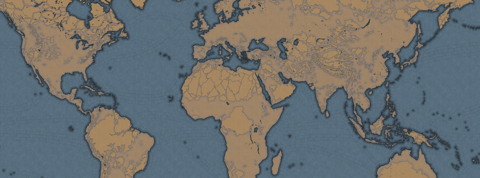
Let's begin with the projection we chose for this game. In the past we have used the Mercator or Miller projection which has some severe drawbacks, as you are all aware of. As we are restricted to a cylindrical map, we had to pick the least bad of them, which is why we went with the Gall Stereographic projection.
Why is that one good? Well, it keeps areas we care most about, those in the middle latitudes, bigger without making the poles ridiculously oversized or the equator too undersized. It also has a reasonable conformal shape, meaning that the shape of the continents stays the closest to their real areas and angles without sacrificing a recognizable shape of them.

In most of our games set in the past, we have used the word of province for the smallest piece of clay on the map. However, with the map design we are doing for this game, it does not really thematically fit, as the map is more granular, and what people associate with a real-world province would not fit. So we went to a terminology we had used in the code since the first game we made in the old Europa Engine, which was “Location.”
So now our smallest subdivision is referred to as a Location, while a group of locations is a Province, and a group of provinces is an Area, and a group of areas is called a Region, and a group of regions is called a Subcontinent, and a group of subcontinents is called a Continent.
If we take the home of Paradox Interactive, it’s located in our location ‘Stockholm,’ which is in the province of ‘Uppland,’ which is in the “Svealand” area, which is in the “Scandinavia” region, which is part of the “Western Europe” sub continent, which is in the “Europe” continent.

Now you may wonder, why did we go with such granularity on a map like this? Well, this is entirely gameplay driven, from making a deep engaging gameplay peacetime possible, to better controlling the pacing of the game, and also to allow for more fun military campaigns.
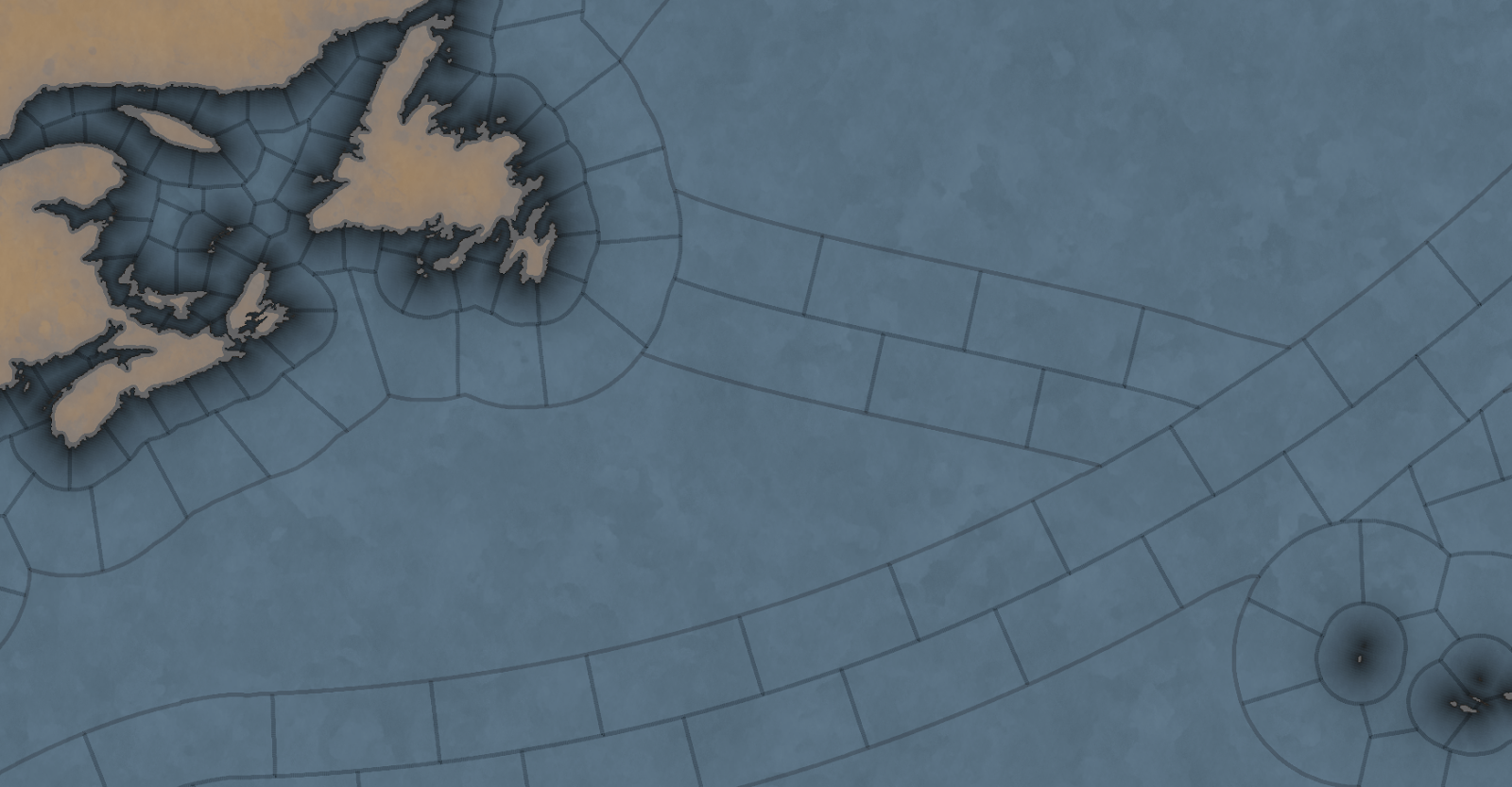
We have tried to make provinces as historical as possible when it comes to borders, while trying to keep the size of the locations consistent, with a more or less regular progression from the smallest to the biggest, with our rule of thumb is that a location shouldn't have more than 3 times the number of pixels compared to a neighboring one.
So is the entire globe then divided into lots of tiny locations? No, as there are 4 types of locations, and for these we have taken heavy inspiration from the maps of Imperator and Victoria 3.
The first type of location is of the more uniform size. For a land location this would be the normal location that can be settled, and for a sea location, this would be a coastal sea location, or any location adjacent to a coastal sea location.
The second type is the “sea current” locations, which connect coastal areas with each other, allowing travel faster in 1 direction.

The third is what we call an “impassable wasteland,” which can be used to describe parts of Sahara, Greenland, or other places where hardly any people live even today. We also use these types for the majority of the water covering the oceans.
Finally, we have what we currently call “passages.” These are land locations that can not be settled by anyone, but can still be traversed by an army, with some insanely heavy attrition, or allow trade to pass through. Think of passages across the Saharan desert.
Speaking of desert... In a lot of our games we define each province as having a single terrain value, like Forest, Tundra, or Desert. This is rather limiting because eventually you end up with a huge list of complex things like “Arctic Forested Hill” or “Desert Mountain.” What we have done in Project Caesar is to take a deep look at how we did this in Victoria 2, where we had split terrain into topography and vegetation, and take it further. Now we have 3 different values in each location:
What the actual gameplay impact of these is, we’ll talk about much later… Sorry.
Next week we’ll be back talking about something that could be rather controversial…
Let's begin with the projection we chose for this game. In the past we have used the Mercator or Miller projection which has some severe drawbacks, as you are all aware of. As we are restricted to a cylindrical map, we had to pick the least bad of them, which is why we went with the Gall Stereographic projection.
Why is that one good? Well, it keeps areas we care most about, those in the middle latitudes, bigger without making the poles ridiculously oversized or the equator too undersized. It also has a reasonable conformal shape, meaning that the shape of the continents stays the closest to their real areas and angles without sacrificing a recognizable shape of them.
In most of our games set in the past, we have used the word of province for the smallest piece of clay on the map. However, with the map design we are doing for this game, it does not really thematically fit, as the map is more granular, and what people associate with a real-world province would not fit. So we went to a terminology we had used in the code since the first game we made in the old Europa Engine, which was “Location.”
So now our smallest subdivision is referred to as a Location, while a group of locations is a Province, and a group of provinces is an Area, and a group of areas is called a Region, and a group of regions is called a Subcontinent, and a group of subcontinents is called a Continent.
If we take the home of Paradox Interactive, it’s located in our location ‘Stockholm,’ which is in the province of ‘Uppland,’ which is in the “Svealand” area, which is in the “Scandinavia” region, which is part of the “Western Europe” sub continent, which is in the “Europe” continent.
Now you may wonder, why did we go with such granularity on a map like this? Well, this is entirely gameplay driven, from making a deep engaging gameplay peacetime possible, to better controlling the pacing of the game, and also to allow for more fun military campaigns.
We have tried to make provinces as historical as possible when it comes to borders, while trying to keep the size of the locations consistent, with a more or less regular progression from the smallest to the biggest, with our rule of thumb is that a location shouldn't have more than 3 times the number of pixels compared to a neighboring one.
So is the entire globe then divided into lots of tiny locations? No, as there are 4 types of locations, and for these we have taken heavy inspiration from the maps of Imperator and Victoria 3.
The first type of location is of the more uniform size. For a land location this would be the normal location that can be settled, and for a sea location, this would be a coastal sea location, or any location adjacent to a coastal sea location.
The second type is the “sea current” locations, which connect coastal areas with each other, allowing travel faster in 1 direction.
The third is what we call an “impassable wasteland,” which can be used to describe parts of Sahara, Greenland, or other places where hardly any people live even today. We also use these types for the majority of the water covering the oceans.
Finally, we have what we currently call “passages.” These are land locations that can not be settled by anyone, but can still be traversed by an army, with some insanely heavy attrition, or allow trade to pass through. Think of passages across the Saharan desert.
Speaking of desert... In a lot of our games we define each province as having a single terrain value, like Forest, Tundra, or Desert. This is rather limiting because eventually you end up with a huge list of complex things like “Arctic Forested Hill” or “Desert Mountain.” What we have done in Project Caesar is to take a deep look at how we did this in Victoria 2, where we had split terrain into topography and vegetation, and take it further. Now we have 3 different values in each location:
- Climate - Includes things like Arid, Arctic, Continental, etc.
- Topography - Flatland, Hills, Mountains etc.
- Vegetation - Forest, Woods, Farmlands, Desert, etc.
What the actual gameplay impact of these is, we’ll talk about much later… Sorry.
Next week we’ll be back talking about something that could be rather controversial…
- 271
- 186
- 16
- 9
- 2

