• We have updated our Community Code of Conduct. Please read through the new rules for the forum that are an integral part of Paradox Interactive’s User Agreement.

Tinto Talks #2 - March 6th, 2024

Welcome to the second week of Tinto Talks, where I talk about the design we have for our new top secret game, which we refer to as “Project Caesar.” Today we’ll delve into everyone's favorite topic, MAPS!

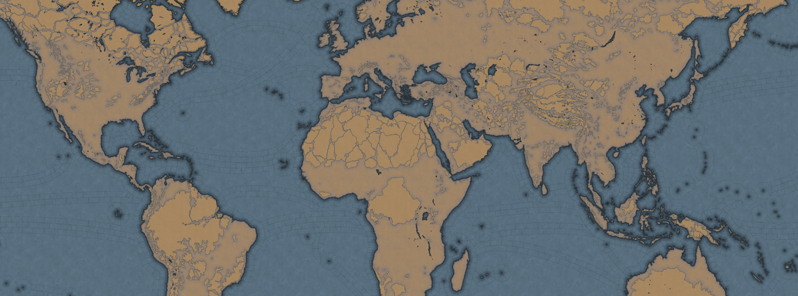
Let's begin with the projection we chose for this game. In the past we have used the Mercator or Miller projection which has some severe drawbacks, as you are all aware of. As we are restricted to a cylindrical map, we had to pick the least bad of them, which is why we went with the Gall Stereographic projection.

Why is that one good? Well, it keeps areas we care most about, those in the middle latitudes, bigger without making the poles ridiculously oversized or the equator too undersized. It also has a reasonable conformal shape, meaning that the shape of the continents stays the closest to their real areas and angles without sacrificing a recognizable shape of them.

_9PYO04WeWxinmQ908H0ppIYzOEd8G2dr52m_sYlaiZCJTC9v8lfhYlwitil4ywR_ubig2b1QpP4bQA4ky64uRQ7K4kbdJ_04sVET3P9zxdJ6iSnlxfUVXloVVO2HyERtafi-H-gZJ3or_Mph8rpu-8


In most of our games set in the past, we have used the word of province for the smallest piece of clay on the map. However, with the map design we are doing for this game, it does not really thematically fit, as the map is more granular, and what people associate with a real-world province would not fit. So we went to a terminology we had used in the code since the first game we made in the old Europa Engine, which was “Location.”

So now our smallest subdivision is referred to as a Location, while a group of locations is a Province, and a group of provinces is an Area, and a group of areas is called a Region, and a group of regions is called a Subcontinent, and a group of subcontinents is called a Continent.

If we take the home of Paradox Interactive, it’s located in our location ‘Stockholm,’ which is in the province of ‘Uppland,’ which is in the “Svealand” area, which is in the “Scandinavia” region, which is part of the “Western Europe” sub continent, which is in the “Europe” continent.

Gre-y6NV8yptHswc5j9-UnVNHPeOEsitmYiVuF2SikujmPsgHVlYhIcfxqYxnFtOuZHuL6oOVwTkiLfLuZ4Mmvfr5q5rFx_pqKjXNd8ESvThSSUMVipKqnMPkr0_R9qJ_MkIp5Z6hkokcvqDF6RXNxg


Now you may wonder, why did we go with such granularity on a map like this? Well, this is entirely gameplay driven, from making a deep engaging gameplay peacetime possible, to better controlling the pacing of the game, and also to allow for more fun military campaigns.

We have tried to make provinces as historical as possible when it comes to borders, while trying to keep the size of the locations consistent, with a more or less regular progression from the smallest to the biggest, with our rule of thumb is that a location shouldn't have more than 3 times the number of pixels compared to a neighboring one.

So is the entire globe then divided into lots of tiny locations? No, as there are 4 types of locations, and for these we have taken heavy inspiration from the maps of Imperator and Victoria 3.

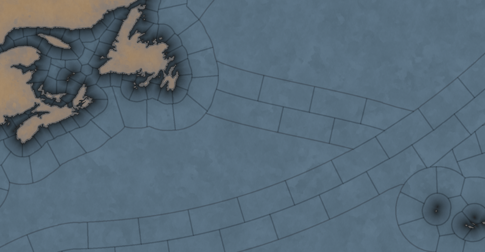
The first type of location is of the more uniform size. For a land location this would be the normal location that can be settled, and for a sea location, this would be a coastal sea location, or any location adjacent to a coastal sea location.

The second type is the “sea current” locations, which connect coastal areas with each other, allowing travel faster in 1 direction.
hxSrFrvpHBRP7C1FzL7yF3v_e1OeEsWIdkc4p9rQwiCUkYKRLlHjcghVclap33tUUDok0b-Bd1AACqYHvsCeVG25A1sKKd-5ua3cLsJVNJwQi-z9bpHG-IuM66UJwVBzg8ofGPX1_JE22mMiHS0y4nU


The third is what we call an “impassable wasteland,” which can be used to describe parts of Sahara, Greenland, or other places where hardly any people live even today. We also use these types for the majority of the water covering the oceans.

Finally, we have what we currently call “passages.” These are land locations that can not be settled by anyone, but can still be traversed by an army, with some insanely heavy attrition, or allow trade to pass through. Think of passages across the Saharan desert.

Speaking of desert... In a lot of our games we define each province as having a single terrain value, like Forest, Tundra, or Desert. This is rather limiting because eventually you end up with a huge list of complex things like “Arctic Forested Hill” or “Desert Mountain.” What we have done in Project Caesar is to take a deep look at how we did this in Victoria 2, where we had split terrain into topography and vegetation, and take it further. Now we have 3 different values in each location:

  • Climate - Includes things like Arid, Arctic, Continental, etc.
  • Topography - Flatland, Hills, Mountains etc.
  • Vegetation - Forest, Woods, Farmlands, Desert, etc.

What the actual gameplay impact of these is, we’ll talk about much later… Sorry.

Next week we’ll be back talking about something that could be rather controversial…
 
  • 267Love
  • 183Like
  • 16
  • 9
  • 2Haha
Reactions:
I was genuinely confused by that post...

Are we sure it wasn't a shitpost?
idk there are some people who believe in that stuff unironically ¯\_(ツ)_/¯
 
  • 1Like
Reactions:
Depicting vassals using shades of their suzerain's color is problematic, because the country map already has way too many colors. I think there are at least 3 better ways to indicate vassalage, all while using the same color for the vassal as for their suzerain: (1) hatching over the suzerain's color, (2) different fonts for the names of vassal and independent countries, and (3) writing the names of independent countries in all caps. If (2) and (3) are found to be insufficient on their own in helping the player distinguish vassals, they can be combined.

https://en.wikipedia.org/wiki/Hatching_(heraldry) (I'm including the link just for the hatching systems there.)

Also, you don't need that many colors on the country map, or on the dynasty and province maps in fact. Believe it or not, 4 are enough.


Maybe it's just me, but the width and shape of the passages, as well as the decision to color them, make them hard to distinguish from actual locations. They could be represented in a more visually distinct way. Perhaps a thin line that comes short of actually touching the locations it links. Maybe dotted, maybe with arrows at both ends.

I'd use a different term for areas. Areas sounds like they should be something smaller than provinces, not larger. (Click her for hot singlewomen in thy provynce.) You could rename them territories (which sound larger than provinces, though the word lacks elegance) or even realms (probably too elegant). Or you could just switch the meanings of the terms area and province.

Some locations, provinces and areas should simply be left nameless. The idea is that they wouldn't stay that way forever, with the first country to conquer a location given the right to name it from a culturally and contextually relevant list (or use their gray matter to come up with something original, if they're not an AI player). In the case of provinces, the naming rights should go to the first country to conquer a location or a percentage of the locations within it; in the case of areas, something analogous. In the case of uninhabited locations that can be settled (such as Madeira or Réunion or St. Helena), naming rights should probably go to the discoverer. I'm not sure what to do about sea locations, because it's not obvious to me whether or not they all already have names by default.

Just to be clear, this isn't me forgetting about the dynamic naming scheme and reinventing the wheel. The game wouldn't have a predetermined notion of what to call a Dutch settlement on the unnamed shore of Table Bay, like it would have for a Dutch Lille (Rijsel), only a long list of options for the player to pick from (one of which would be Kaapstad, a name that can be given to any settlement established near a cape).

Say I'm playing as a colonial-focused Brittany under the House of Valois and with a Francophone court. I should have a list of names such as Assomption, Brest des Indes, Fort-Valois, Îles Malouines, Mer de Saint-Jean-Baptiste, Nouvelle-Rennes, Nova Armorica, Port-au-Duc, Saint-Judicaël, and Terre de Pâques that I can bestow upon unnamed places.

After all, if so many of the toponyms on our map were made up post-1337, why not actively put the player in the role of name-giver? It opens up a whole new aspect of the history-making experience, and just so happens to greatly reduce your research workload. It's an easy way to add more locations where the list of available indigenous place-names in the historical record can't keep up with the geographical expanse you need to cover, like Tasmania, Zambia or the East Coast of the United States.

For the sake of brevity, the words Northern, Southern, Western, and Eastern in the names of provinces, areas and cultures should be replaced with North, South, West, and East, respectively. Unless, of course, there's historical usage to the contrary - if the game's starting date was 1937, I wouldn't recommend North Ireland. Some of those names get rather long, and the people this game will be played by are more likely than most to notice inconsistencies. Central should give way to Middle, not because it's briefer but because it sounds more age-approp... more era-appropriate.

When the name of a province or area is meant to be in English, replace Haut, Haute and Ober with Upper, and Bas, Basse and Unter with Under, except in cases where the native form is well-established in English, though I don't think there are any. Same with the cardinal directions; do we really need Sønderjylland when South Jutland would be so much easier on anyone who doesn't speak one of the Scandinavian languages, including Germans actually living there? ("Special what-land?")

I would try, as much as possible, to avoid using the same name for provinces as for locations (and for areas as for provinces). The exception is where the province roughly corresponds to a historical territory that has the same name as a location, such as Jaén and Luxembourg. That's why my list of proposed province names has a few... well, more than a few instances of X & Y.

And I did mean to use the ampersand there. In the case of compound province and area names, the hyphen or the word and that joins different elements should be replaced with an ampersand, unless there's historical usage to the contrary. So Vukovar & Syrmia instead of Vukovar-Syrmia, and Savoy & Dauphiné instead of Savoy and Dauphiné. First, this avoids the possibility of a compound name that's longer than 3 words (without the joining element) being misconstrued. 2nd, the ampersand can stay the same in all languages, whereas the word and would need to be translated. 3rd, the ampersand is briefer than and. And 4th, while the hyphen is even briefer, it feels out of place for the time period covered by the game.

For reasons that I admit are entirely subjective, I'd also try to avoid using the names of geographical features (such as the Dardanelles) for province names. This one comes with 3 exceptions: established names of historical territories (Zeta), names of islands and archipelagoes (Balearic Islands) and the law of convenience.

What the law of convenience means is that a name like X & Y works just fine when the province is a small corner of Belgium and X and Y are towns or cities that we know for a fact existed in 1337, but when the province is a slice of sub-Saharan Africa larger than all of Belgium where any 1337 placenames are barely even speculative, X & Y would just be ridiculous. These are the cases where a name like Upper Nile can be justified.

It's inconsistent that some one-location islands are named after their main settlement (Hammershus, on the island of Bornholm) but some are named after the island itself (Öland, in the same sea as Bornholm). It should be one or the other, preferably the latter.

Some islands are depicted on the map even though they're not their own location, but attached to either a mainland location (like the Hanish Islands, part of Zabīd - a town which isn't even on the coast) or a different island (like El Hierro, part of Santa Cruz de Gomera). If they're not deemed to be important enough to merit their own location, then just remove them from the map. People will be too busy complaining that the Dutch coast is anachronistic to bother counting your Canaries. If it should happen that the location is named after the island, rename it. (Sorry, Kish.)

Would it be possible to create a special kind of location for wasteland coasts? Uninhabited and not open for settlement, but allowing the player to build certain military and economic buildings, like shore establishments and whaling stations. The fact that it's not a place I'd ever move to doesn't mean it can't be valuable for purely geographical reasons.
 
  • 3
  • 1
Reactions:
Depicting vassals using shades of their suzerain's color is problematic, because the country map already has way too many colors

Also, you don't need that many colors on the country map
I completely disagree, just 4 is not enough, like, why not orange, white, grey, purple, pink etc? If it was only 4 colours the map would look super confusing.

Isn't it better anyway that almost every country has its special colour rather than have the same reds, yellows, greens and blues everywhere?
Almost every poltical map in strategy games uses more than just 4. It is just limiting and doesn't make a lot of sense for like 300 countries that regulary change shapes.

At least 10 colours I would say. You present 4 colour theorem but countries in game are dynamic and well you will soon have blue country touching another blue country if there were only 4 colours.

It would make sense in maybe like a map mode that looks at provinces or regions (that are more or less static and don't change borders) of one country only but not for political mode.

Also things like Byzantium is just heresy not to show in shade of purple! Or The Netherlands not in orange.

Vassals having sligtly lighter hue makes a lot of sense as many maps use this to show it. That or stipes, but they are already used for conquest.

Would it be possible to create a special kind of location for wasteland coasts? Uninhabited and not open for settlement, but allowing the player to build certain military and economic buildings, like shore establishments and whaling stations.
This I agree with, it would be cool if we could set up like outposts in areas that wouldn't be fitting for a true colony. This to stop large areas like Baffin Island not having anyone claim on it and remaining a large grey landmass.
 
  • 1Like
Reactions:
I completely disagree, just 4 is not enough, like, why not orange, white, grey, purple, pink etc? If it was only 4 colours the map would look super confusing.

Isn't it better anyway that almost every country has its special colour rather than have the same reds, yellows, greens and blues everywhere?
Almost every poltical map in strategy games uses more than just 4. It is just limiting and doesn't make a lot of sense for like 300 countries that regulary change shapes.

At least 10 colours I would say. You present 4 colour theorem but countries in game are dynamic and well you will soon have blue country touching another blue country if there were only 4 colours.
You've made me reconsider on this. It had completely escaped my mind that the country and dynasty map would change throughout the game.
Vassals having sligtly lighter hue makes a lot of sense as many maps use this to show it. That or stipes, but they are already used for conquest.
But here you haven't convinced me at all. A hue of a color is just another color. There are already a lot of colors on the country map if you put aside vassals, adding even more for vassals inevitably leads to instances when you can't tell whether a country is meant to be a vassal or just happens to have a color very similar to a neighbor, instances of vassals sandwiched between countries with similar colors that leave you unable to identify which (if any) it's meant of be a vassal of, and instances of vassals distant enough from their suzerain that you wouldn't initially assume they're a vassal at all.

Is Normandy a French vassal? How about Lorraine? Is Achaia a vassal of Naples or the Byzantines? Or is it an independent country? Is Salona a vassal of Athens or Sicily? Or are they Salona's vassals?


Even if you set up all the colors perfectly at the game's start date to avoid confusion, as you pointed out, countries are dynamic. Such confusing situations will appear on their own. At the very least you need something to differentiate vassal from non-vassal countries. It doesn't have to be hatching, it just has the advantages of (1) standing out better than the other methods I thought of., and (2) making it clear which suzerain the vassal belongs to.
 
Depicting vassals using shades of their suzerain's color is problematic, because the country map already has way too many colors. I think there are at least 3 better ways to indicate vassalage, all while using the same color for the vassal as for their suzerain: (1) hatching over the suzerain's color, (2) different fonts for the names of vassal and independent countries, and (3) writing the names of independent countries in all caps. If (2) and (3) are found to be insufficient on their own in helping the player distinguish vassals, they can be combined.

https://en.wikipedia.org/wiki/Hatching_(heraldry) (I'm including the link just for the hatching systems there.)

Also, you don't need that many colors on the country map, or on the dynasty and province maps in fact. Believe it or not, 4 are enough.


Maybe it's just me, but the width and shape of the passages, as well as the decision to color them, make them hard to distinguish from actual locations. They could be represented in a more visually distinct way. Perhaps a thin line that comes short of actually touching the locations it links. Maybe dotted, maybe with arrows at both ends.

I'd use a different term for areas. Areas sounds like they should be something smaller than provinces, not larger. (Click her for hot singlewomen in thy provynce.) You could rename them territories (which sound larger than provinces, though the word lacks elegance) or even realms (probably too elegant). Or you could just switch the meanings of the terms area and province.

Some locations, provinces and areas should simply be left nameless. The idea is that they wouldn't stay that way forever, with the first country to conquer a location given the right to name it from a culturally and contextually relevant list (or use their gray matter to come up with something original, if they're not an AI player). In the case of provinces, the naming rights should go to the first country to conquer a location or a percentage of the locations within it; in the case of areas, something analogous. In the case of uninhabited locations that can be settled (such as Madeira or Réunion or St. Helena), naming rights should probably go to the discoverer. I'm not sure what to do about sea locations, because it's not obvious to me whether or not they all already have names by default.

Just to be clear, this isn't me forgetting about the dynamic naming scheme and reinventing the wheel. The game wouldn't have a predetermined notion of what to call a Dutch settlement on the unnamed shore of Table Bay, like it would have for a Dutch Lille (Rijsel), only a long list of options for the player to pick from (one of which would be Kaapstad, a name that can be given to any settlement established near a cape).

Say I'm playing as a colonial-focused Brittany under the House of Valois and with a Francophone court. I should have a list of names such as Assomption, Brest des Indes, Fort-Valois, Îles Malouines, Mer de Saint-Jean-Baptiste, Nouvelle-Rennes, Nova Armorica, Port-au-Duc, Saint-Judicaël, and Terre de Pâques that I can bestow upon unnamed places.

After all, if so many of the toponyms on our map were made up post-1337, why not actively put the player in the role of name-giver? It opens up a whole new aspect of the history-making experience, and just so happens to greatly reduce your research workload. It's an easy way to add more locations where the list of available indigenous place-names in the historical record can't keep up with the geographical expanse you need to cover, like Tasmania, Zambia or the East Coast of the United States.

For the sake of brevity, the words Northern, Southern, Western, and Eastern in the names of provinces, areas and cultures should be replaced with North, South, West, and East, respectively. Unless, of course, there's historical usage to the contrary - if the game's starting date was 1937, I wouldn't recommend North Ireland. Some of those names get rather long, and the people this game will be played by are more likely than most to notice inconsistencies. Central should give way to Middle, not because it's briefer but because it sounds more age-approp... more era-appropriate.

When the name of a province or area is meant to be in English, replace Haut, Haute and Ober with Upper, and Bas, Basse and Unter with Under, except in cases where the native form is well-established in English, though I don't think there are any. Same with the cardinal directions; do we really need Sønderjylland when South Jutland would be so much easier on anyone who doesn't speak one of the Scandinavian languages, including Germans actually living there? ("Special what-land?")

I would try, as much as possible, to avoid using the same name for provinces as for locations (and for areas as for provinces). The exception is where the province roughly corresponds to a historical territory that has the same name as a location, such as Jaén and Luxembourg. That's why my list of proposed province names has a few... well, more than a few instances of X & Y.

And I did mean to use the ampersand there. In the case of compound province and area names, the hyphen or the word and that joins different elements should be replaced with an ampersand, unless there's historical usage to the contrary. So Vukovar & Syrmia instead of Vukovar-Syrmia, and Savoy & Dauphiné instead of Savoy and Dauphiné. First, this avoids the possibility of a compound name that's longer than 3 words (without the joining element) being misconstrued. 2nd, the ampersand can stay the same in all languages, whereas the word and would need to be translated. 3rd, the ampersand is briefer than and. And 4th, while the hyphen is even briefer, it feels out of place for the time period covered by the game.

For reasons that I admit are entirely subjective, I'd also try to avoid using the names of geographical features (such as the Dardanelles) for province names. This one comes with 3 exceptions: established names of historical territories (Zeta), names of islands and archipelagoes (Balearic Islands) and the law of convenience.

What the law of convenience means is that a name like X & Y works just fine when the province is a small corner of Belgium and X and Y are towns or cities that we know for a fact existed in 1337, but when the province is a slice of sub-Saharan Africa larger than all of Belgium where any 1337 placenames are barely even speculative, X & Y would just be ridiculous. These are the cases where a name like Upper Nile can be justified.

It's inconsistent that some one-location islands are named after their main settlement (Hammershus, on the island of Bornholm) but some are named after the island itself (Öland, in the same sea as Bornholm). It should be one or the other, preferably the latter.

Some islands are depicted on the map even though they're not their own location, but attached to either a mainland location (like the Hanish Islands, part of Zabīd - a town which isn't even on the coast) or a different island (like El Hierro, part of Santa Cruz de Gomera). If they're not deemed to be important enough to merit their own location, then just remove them from the map. People will be too busy complaining that the Dutch coast is anachronistic to bother counting your Canaries. If it should happen that the location is named after the island, rename it. (Sorry, Kish.)

Would it be possible to create a special kind of location for wasteland coasts? Uninhabited and not open for settlement, but allowing the player to build certain military and economic buildings, like shore establishments and whaling stations. The fact that it's not a place I'd ever move to doesn't mean it can't be valuable for purely geographical reasons.
I greatly agree with nearly everything in this post, however, the four-colour theorem doesn't apply to maps with exclaves, so it wouldn't work for the political or dynastic maps.

Also, when it's said that independent countries and subject countries should use different fonts, I hope we don't mean different fonts proper, but rather capitalisation or boldness.

Also, it's a bit odd that you say that making subjects a shade of their overlord's colour is confusing, but then say that we should just have them be their own shade. Personally I don't mind them being shades, but crosshatching would be neat as well. I also think it could be indicated by drawing an outline of the overlord's colour around subject nations.
 
  • 1Like
Reactions:
I greatly agree with nearly everything in this post, however, the four-colour theorem doesn't apply to maps with exclaves, so it wouldn't work for the political or dynastic maps.
I already gave up on the 4 color approach for the country and dynasty maps because someone pointed out that those maps are dynamic. You can set up the initial map so that no 2 neighboring countries/dynasties have the same color, and 4 colors would be sufficient for that, but then it's almost inevitable that expansion will lead to countries with the same color bordering each other. So it only makes sense for the province map.
Also, when it's said that independent countries and subject countries should use different fonts, I hope we don't mean different fonts proper, but rather capitalisation or boldness.
What's wrong with different fonts? You only need 2, one for independent countries and one for vassals. I'm not saying that every country should have its own font.

That said, since some people seem attached to certain countries having specific colors, it may be worth looking into certain cultures or culture groups having specific fonts for their countries/dynasties. I wouldn't mind seeing Gaelic type for the Goidels, or at least a more easily readable version of it. Obviously this stuff should be optional.
Also, it's a bit odd that you say that making subjects a shade of their overlord's colour is confusing, but then say that we should just have them be their own shade. Personally I don't mind them being shades, but crosshatching would be neat as well. I also think it could be indicated by drawing an outline of the overlord's colour around subject nations.
You misunderstand. The proposal was that vassals should be the same color as their suzerain, and should be differentiated by hatching or by the characteristics of the text. This way you can easily tell who the suzerain is supposed to be when independent countries of similar colors are next to each other, and you can easily tell that a country is someone else's vassal when it's suzerain isn't in your field of vision.
 
  • 1
Reactions:
How much would we be allowed to modify the geography through gameplay? Even though you'll end the game before the big construction projects of the 19th and 20th centuries, there were a number of canals that were either built or at least under consideration before 1800: Bridgewater, Bydgoszcz, Eider, Ladoga, Midi (built), Corinth, Suez, and Volga-Don (under consideration), to name a few. Another example are polders - not the big ones that can act as one or even several locations, like the Flevopolder, but the small ones that would basically function as improvements to a location, like Achtermeer. Finally, there's the Dutch waterlines, which I don't think any player trying to defend the northwestern Low Countries from a land invasion would mind having.

Will portages be a feature in calculating distance? Think of them as a really slow river. They certainly had their part to play in Russian history.

Can we expect different locations in the game to periodically be affected by natural disasters? If so, my thinking is that tectonic events should proceed as they did historically and weather events should be randomized. The former are almost literally set in stone, nothing that happens on the surface is likely to influence them. Whereas the latter are so sensitive to even the most minor alteration that it's the origin of the butterfly effect metaphor.

Will we see the Yellow River change course, which is something it's done many times throughout its history? If so, given the fact that the cause was usually floods (the result of weather events), it should do so randomly. Partly for the sake of realism, but partly so a human player won't know when the changes are coming.
 
  • 2
Reactions:
How much would we be allowed to modify the geography through gameplay? Partly for the sake of realism, but partly so a human player won't know when the changes are coming.
I also thought that the real map of the medieval world should be a bit different from the modern map from Google maps.

Especially the contours of the coastline should be a bit different:

"During the Little Ice Age, from 1300 to 1850 - when temperatures were the coldest for any time in the last 10,000 years - snow and ice accumulated in Greenland, Antarctica, Europe and glaciers around the world. As a result, sea levels dropped so much that important ancient Roman and medieval port cities (such as Ephesus, Ostia, Antica and Pisa) remained miles from the Mediterranean Sea.''

When playing EU4, I have never saw any events for the Little Ice Age (which is divided into three stages with periods of temporary warming).
Maybe EU5 will to pay more attention for this?

Just so that to understand the impact of the Little Ice Age - Russians invaded Sweden in1809 just by crossing the Baltic Sea on ice by foots!
 
Last edited:
  • 1
  • 1Like
Reactions:
I also thought that the real map of the medieval world should be a bit different from the modern map from Google maps.

Especially the contours of the coastline should be a bit different:

"During the Little Ice Age, from 1300 to 1850 - when temperatures were the coldest for any time in the last 10,000 years - snow and ice accumulated in Greenland, Antarctica, Europe and glaciers around the world. As a result, sea levels dropped so much that important ancient Roman and medieval port cities (such as Ephesus, Ostia, Antica and Pisa) remained miles from the Mediterranean Sea.''
This changed sea levels by only a few metres, It was significant and had meaningful effects as you say, but on the scale of the in-game map, it would probably not cause more than a few pixels of change anywhere. This point was also raised with regards to the Bothnian region, which has experienced significant uplift over the course of the game time period due to post-glacial rebound, but when it was looked into, it was concluded that the difference would only be a few pixels. A few pixels is a lot to people living on the ground, though. So these events should be represented as events.

On the other hand, there some river deltas where there has been significant deposition which in some cases I think might be enough to approach the size of individual locations. For example, here is a map illustrating how much the Jiangsu coastline changed over the course of the game.

1727537864762.png
 
  • 1
Reactions:
This changed sea levels by only a few metres, It was significant and had meaningful effects as you say, but on the scale of the in-game map, it would probably not cause more than a few pixels of change anywhere.
Well, in Pomerelia / Royal Prussia the change was quite significant:
1727553156654.jpeg

1727553234331.png

And we can thank the Dutch for that: https://en.wikipedia.org/wiki/Olenders
 
Last edited: