• We have updated our Community Code of Conduct. Please read through the new rules for the forum that are an integral part of Paradox Interactive’s User Agreement.

Tinto Talks #2 - March 6th, 2024

Welcome to the second week of Tinto Talks, where I talk about the design we have for our new top secret game, which we refer to as “Project Caesar.” Today we’ll delve into everyone's favorite topic, MAPS!

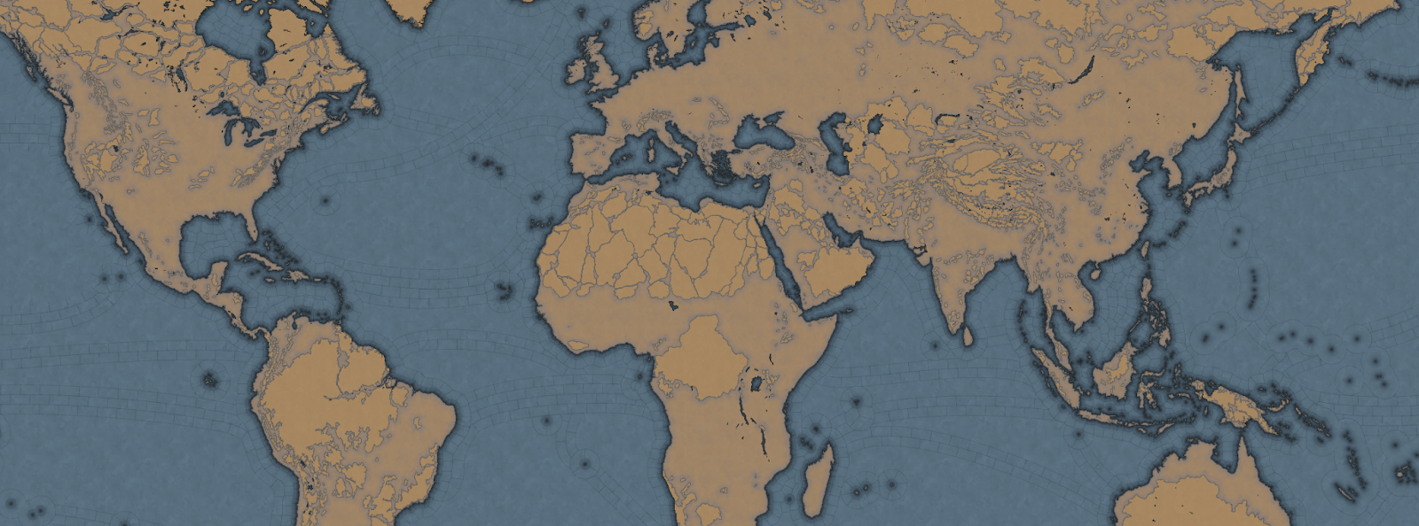
Let's begin with the projection we chose for this game. In the past we have used the Mercator or Miller projection which has some severe drawbacks, as you are all aware of. As we are restricted to a cylindrical map, we had to pick the least bad of them, which is why we went with the Gall Stereographic projection.

Why is that one good? Well, it keeps areas we care most about, those in the middle latitudes, bigger without making the poles ridiculously oversized or the equator too undersized. It also has a reasonable conformal shape, meaning that the shape of the continents stays the closest to their real areas and angles without sacrificing a recognizable shape of them.

_9PYO04WeWxinmQ908H0ppIYzOEd8G2dr52m_sYlaiZCJTC9v8lfhYlwitil4ywR_ubig2b1QpP4bQA4ky64uRQ7K4kbdJ_04sVET3P9zxdJ6iSnlxfUVXloVVO2HyERtafi-H-gZJ3or_Mph8rpu-8


In most of our games set in the past, we have used the word of province for the smallest piece of clay on the map. However, with the map design we are doing for this game, it does not really thematically fit, as the map is more granular, and what people associate with a real-world province would not fit. So we went to a terminology we had used in the code since the first game we made in the old Europa Engine, which was “Location.”

So now our smallest subdivision is referred to as a Location, while a group of locations is a Province, and a group of provinces is an Area, and a group of areas is called a Region, and a group of regions is called a Subcontinent, and a group of subcontinents is called a Continent.

If we take the home of Paradox Interactive, it’s located in our location ‘Stockholm,’ which is in the province of ‘Uppland,’ which is in the “Svealand” area, which is in the “Scandinavia” region, which is part of the “Western Europe” sub continent, which is in the “Europe” continent.

Gre-y6NV8yptHswc5j9-UnVNHPeOEsitmYiVuF2SikujmPsgHVlYhIcfxqYxnFtOuZHuL6oOVwTkiLfLuZ4Mmvfr5q5rFx_pqKjXNd8ESvThSSUMVipKqnMPkr0_R9qJ_MkIp5Z6hkokcvqDF6RXNxg


Now you may wonder, why did we go with such granularity on a map like this? Well, this is entirely gameplay driven, from making a deep engaging gameplay peacetime possible, to better controlling the pacing of the game, and also to allow for more fun military campaigns.

We have tried to make provinces as historical as possible when it comes to borders, while trying to keep the size of the locations consistent, with a more or less regular progression from the smallest to the biggest, with our rule of thumb is that a location shouldn't have more than 3 times the number of pixels compared to a neighboring one.

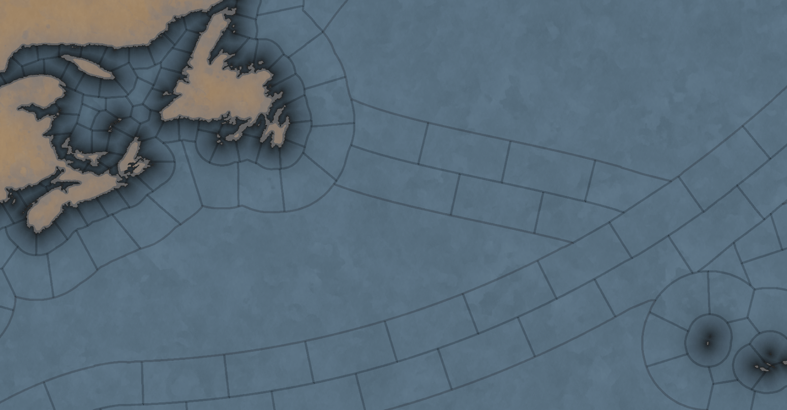
So is the entire globe then divided into lots of tiny locations? No, as there are 4 types of locations, and for these we have taken heavy inspiration from the maps of Imperator and Victoria 3.

The first type of location is of the more uniform size. For a land location this would be the normal location that can be settled, and for a sea location, this would be a coastal sea location, or any location adjacent to a coastal sea location.

The second type is the “sea current” locations, which connect coastal areas with each other, allowing travel faster in 1 direction.
hxSrFrvpHBRP7C1FzL7yF3v_e1OeEsWIdkc4p9rQwiCUkYKRLlHjcghVclap33tUUDok0b-Bd1AACqYHvsCeVG25A1sKKd-5ua3cLsJVNJwQi-z9bpHG-IuM66UJwVBzg8ofGPX1_JE22mMiHS0y4nU


The third is what we call an “impassable wasteland,” which can be used to describe parts of Sahara, Greenland, or other places where hardly any people live even today. We also use these types for the majority of the water covering the oceans.

Finally, we have what we currently call “passages.” These are land locations that can not be settled by anyone, but can still be traversed by an army, with some insanely heavy attrition, or allow trade to pass through. Think of passages across the Saharan desert.

Speaking of desert... In a lot of our games we define each province as having a single terrain value, like Forest, Tundra, or Desert. This is rather limiting because eventually you end up with a huge list of complex things like “Arctic Forested Hill” or “Desert Mountain.” What we have done in Project Caesar is to take a deep look at how we did this in Victoria 2, where we had split terrain into topography and vegetation, and take it further. Now we have 3 different values in each location:

  • Climate - Includes things like Arid, Arctic, Continental, etc.
  • Topography - Flatland, Hills, Mountains etc.
  • Vegetation - Forest, Woods, Farmlands, Desert, etc.

What the actual gameplay impact of these is, we’ll talk about much later… Sorry.

Next week we’ll be back talking about something that could be rather controversial…
 
  • 267Love
  • 183Like
  • 16
  • 9
  • 2Haha
Reactions:
Well.. its sadly lesser priority than making Värmdö look good
Hahah that’s fair. But in all seriousness I think Ekerö should be on the map. It’s got stuff like Birka and several early kings ruled from Munsö. The royal palace is also in Ekerö and Mälaren just looks empty without it… then again I’m not the one who’s making EU5 and it’s not like the game will be bad if Ekerö isn’t there!
 
Sorry if this has already been asked but why are the American Appalachians so impassable? In fact they look more obstructive than the Rockies on this map. I live in the Appalachians and I must say they are very passable and were used extensively by native Americans before colonization. In modern times plenty of people live on or right next to the Appalachians, it is a very old and mostly short and gentle mountain range.
 
  • 1
Reactions:
For those of you interested in how the map projections differ, here is a comparison from Map Projections

As you can see, Gall gives much larger areas for every location between 45°S and 45°N, while latitudes nearby polar circles are compressed.

I'm personally not particularly a fan of the huge north-south conformal (shape) distortion along the equator (mostly visible in Africa, Indonesia, Arabia, Brazil and Australia), but this is a personal taste. I prefer for that the Braun sterographic projection, similar to Gall but which at least keeps a conformal faithfulness along the equator, especially when graticules are visible.
Also Miller, despite its underrepresentation of Africa's size, at least keeps most of the world shape with minimum shape distortion, if not distance.

I do get why the devs decided for this one though. Apart from the balance between conformal / distance, cultural reasons (not underrepresenting areas), it also gives more pixels to paint provinces in high population density latitudes. More pixels = more provinces (especially in Japan and HRE) without struggling for the clickable area.

1710621175337.png


Miller deformation Tissot indicatrix.
Equator being fully conformal, then locations get horizontally stretched the further north/south
1710621795482.jpeg


Gall deformation Tissot indicatrix.
45° standard latitude (Europe, Central Asia, Japan, northern USA) being almost fully conformal, Siberia / Northern Canada (and antarctica for that matter) being horizontall stretched.
Brazil, West Africa, Central Africa, East AFrica, Arabia, South and East Asia being vertically stretched. Also Patagonia, Maghreb and Australia but to a lesser degree
1710621814858.jpeg
 

Attachments

  • 1710621780931.jpeg
    1710621780931.jpeg
    159,4 KB · Views: 0
Last edited:
I do really hope that either via MT/Events, or just for moders you will add option of changing vegetation (Forest, Woods, Farmlands, Desert, etc.) of location.

Via huge investment of resources deforesting location to change it into grassland and then farmlands would be great and I was always looking for it in Eu4.
Grey Eminence had (or was teased to have) a feature where each province has a forest value that can decrease as people develop more land for agriculture. I'd very much like some system like this, not necessarily exactly the same, but at least something where colonisation or population growth can lead to conversion of forests into farmland, being in the game.
 
  • 1Like
Reactions:
Grey Eminence had (or was teased to have) a feature where each province has a forest value that can decrease as people develop more land for agriculture. I'd very much like some system like this, not necessarily exactly the same, but at least something where colonisation or population growth can lead to conversion of forests into farmland, being in the game.
Or Dutch draining the swamps.
 
  • 3Like
  • 1
Reactions:
Il kie that fact that, contrary to EU games, the southern tip of South America seems to go much further south than the southern coast of Africa.

And those oceanic wastelands are brilliant !
 
  • 1Like
Reactions:
The map granularity and the climate/ topography/ vegetation distinction are promising!

But please add natural disasters. Tsunamis, earthquakes, storms, fires, floods and specific phenomenons like El Niño.

Even a map mode for climatic disaster risks. Where some locations can read info like "an Earthquakes may happen around this area approximately every 2 decades. Last Earthquake was on mm/dd/yyyy", " Tornadoes may appear during winter in this province", "Tsunamis from the coast of Japan may arrive to this American coast in X days", etc.

This should definitely have some impact on the flow of commerce, the safety of naval units, the price of otherwise equivalent naval units, the safety of armies, infrastructure of affected locations, and even religious reactions of some pops dependending on the year and culture where the disaster happened. Also impact on diplomatic relations and favors by sending aid to affected nations or the simple fact that disasters leave countries more exposed to external invasions.
 
Last edited:
  • 1
Reactions:
I mean I am not a fan of mana as it is in EU4 but I feel like there needs to be a way to differentiate the skill levels of leaders and should have an effect on your country. Not sure how it should be implemented however
CK3 skills does that in a way. Without using mana, but using the efficiency of your ruler or its counselor to increase or decrease the speed of actions (culture or religious conversion, de jure title assimilation, improving relations, or even researching techs)
 

In order to avoid dynamic text to be too small in locations (as in Stockholm here), while on the contrary central Asian steppe and Siberian locations would have huge text, would you consider
replacing it for location size only by a CK3 type of baronies names (horizontal, lowercase, uniform font size) ?

Dynamic text (uppercase, variable orientation and font size) could be kept for provinces, areas; regions and subcontinents size. Similar to how old maps used to represent “city names” or bay/port names VS region / country names

It would also help avoiding huge text discrepancy between neighboring locations of different pixel count, as you said rule of thumb is up to 3 times location size (meaning 3 times text size)

How it currently looks like in a desert area close to a dense area.
VS how it could look like. An example I modded, although within the limits of what was possible in EU4 engine, ie. no name frame.
1710765646849.png
1710766434781.png


Still retaining the same style when zooming out for regions or country names
1710767103276.png
1710767130487.png


Examples from CK3, VIC 3 with name frame and and HOI4 without name frame
1710755246478.png
1710755632698.png


Or HOI4 victory points (cities) names, although obviously with a font and graphic design adapted to the period.

1710765587320.png


Historical map examples, showing region names as uppercase and sometimes diagonal, with cities lowercase and horizontal (click to enlarge)

1710766630770.jpeg
1710766682723.jpeg
1710756035197.jpeg

It would also help visually representing (for immersion) the “scarcity” of population density in the steppes, as city names would be more distant to one another, while places with high population density like Western Europe / east Asia and South Asia would have denser locations
 

Attachments

  • 1710754833343.png
    1710754833343.png
    1,7 MB · Views: 0
  • 1710754977347.png
    1710754977347.png
    3,1 MB · Views: 0
  • 1710755768357.jpeg
    1710755768357.jpeg
    398,9 KB · Views: 0
  • 1710755996578.jpeg
    1710755996578.jpeg
    30,8 KB · Views: 0
  • 1710756570611.png
    1710756570611.png
    321,8 KB · Views: 0
  • 1710767067819.png
    1710767067819.png
    3,9 MB · Views: 0
Last edited:
  • 1
  • 1Like
Reactions:
Noticed where the city of Belo Horizonte is in Brazil is marked as impassible terrain, along with other valleys. I hope that part of Brazil gets some more work, as the area is characterized by isolated fertile valleys separated by mountains and escarpments.
 
  • 1Like
Reactions:
Noticed where the city of Belo Horizonte is in Brazil is marked as impassible terrain, along with other valleys. I hope that part of Brazil gets some more work, as the area is characterized by isolated fertile valleys separated by mountains and escarpments.
I think it would be a great idea for the devs to open a thread where the community is invited to make map suggestions, and all of the people wielding specific corrections about their own region can be heard. Though it might be a bit early in development for that.
 
  • 3Like
  • 1
Reactions:
I think it would be a great idea for the devs to open a thread where the community is invited to make map suggestions, and all of the people wielding specific corrections about their own region can be heard. Though it might be a bit early in development for that.
It probably is too early indeed, since we still have to wait for the game to unravel progressively through dev diaries. we still have time. So far, they seem to prioritize exposing the creative choices.

As a modder, I’m more worried (or not actually, since so far I’m pretty happy with the creative choices) by the gameplay mechanics. Adding provinces is something which can easily be modded, but mechanics can’t (or only within the frame they were developed for)
 
  • 1
Reactions:
I hope they don't shy away from it. This is pretty much a history simulator. Slavery is very important to be represented, both transatlantic and otherwise. I don't like how it is in EU4 at all. Here's hoping!
Having Slaves as a “good” (as in the trade good) is abysmal imo - pops at least give a more alive feeling
 
  • 1
  • 1Like
Reactions:
Really like most of the map approach here, and adding locations to the mix sounds intriguing but potentially very valuable (only concern is performance, which I'm quite sure will have been considered).

The third is what we call an “impassable wasteland,” which can be used to describe parts of Sahara, Greenland, or other places where hardly any people live even today. We also use these types for the majority of the water covering the oceans.

The only thing that raises an eyebrow is impassable wastelands for water. EU4's weakest element from my perspective is its representation of things maritime, and there's no real reason to arbitrarily restrict large areas of the sea unless the game represents the ancient world where ships generally didn't stray far from the shore (in which case "current" channels would be unnecessary). Nick Collins has recently released a couple good-looking books on big trends in maritime history that I'd strongly recommend (the particular book depending on the time period of the game in question of the game :) ) for providing a broad overview of maritime developments in the period.

The other thing that two-lane channels across the sea suggests is the risk of lots of battles out at sea in the middle of the ocean. The ocean is a big place, and as best I understand it, the vast majority of naval conflict prior to the age of steam (and probably most afterwards too) occurred close to land, in no small part because two fleets travelling across the ocean are very unlikely to bump into each other. The way the map looks, there's a risk there'll be a lot of historically implausible open-sea engagements. It also just feels odd that ships will be restricted to certain channels - as best I understand it, that certainly wasn't the case historically - the big value of maritime travel/communication was its flexibility (one of the reasons maritime trade remains the engine of the global economy to this day).

There's also value in having open seas in the Med as well, rather than impassable blobs in the middle.

Last thing which I expect these channels also cover is trade winds. I'm fairly sure that trade winds were more important than currents (to the point that framing them in the context of trade winds makes more sense than currents), but need to read up a bit more on that before I can say that with confidence.
 
  • 1
  • 1
Reactions:
Hey I do like the map, and it is a good idea to make the ocean a bit more restricted than before to make naval play a bit more strategic, but I have to suggest a few changes on the atlantic sea lanes (And to a minor degree the ones in the indian ocean).

You currently having them set up like this kinda doesn't reflect the more usual routes specially between portugal/spain and south america.

1711113899753.png

Here is a comparison from the more famous maps of the great navigations

1711114057969.png


As you can see the usual routes were far more direct. A lack of a more direct route between Portugal and Brazil would harm the believability of how Portugal related and controlled their colony.

Similarly, therere seems to be a lack of some of those direct routes in the east.


As nice as it is to have ocean "lanes" they really should reflect the main streams of navigations between those regions, otherwise they just feel arbitrarily restrictive.
 
  • 2Like
  • 1
Reactions:
A comment on the sea lanes, I think it would look a bit less jarring if you had 'turnaround triangles' on the currents. So mechanically if someone realized they needed to do so they could reverse a bit faster and it might sometimes be more optimal.

But more importantly the 'ocean wastelands' would look nicer.