• We have updated our Community Code of Conduct. Please read through the new rules for the forum that are an integral part of Paradox Interactive’s User Agreement.

Tinto Talks #2 - March 6th, 2024

Welcome to the second week of Tinto Talks, where I talk about the design we have for our new top secret game, which we refer to as “Project Caesar.” Today we’ll delve into everyone's favorite topic, MAPS!

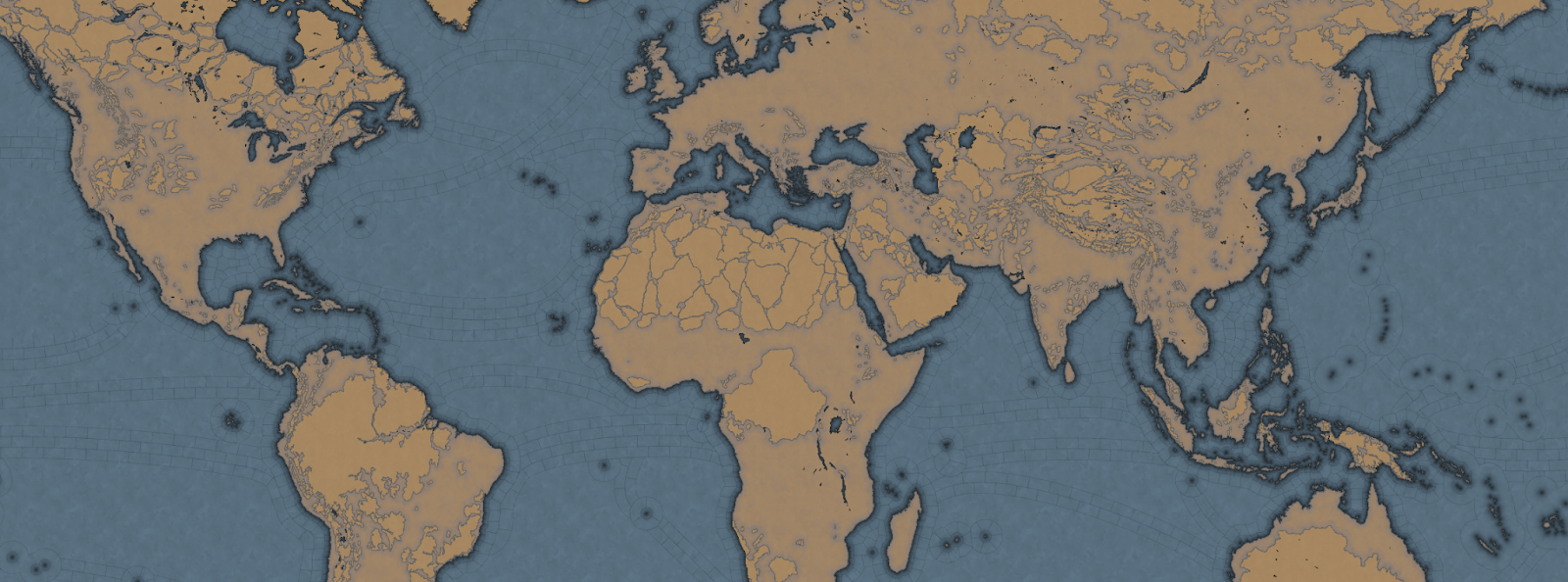
Let's begin with the projection we chose for this game. In the past we have used the Mercator or Miller projection which has some severe drawbacks, as you are all aware of. As we are restricted to a cylindrical map, we had to pick the least bad of them, which is why we went with the Gall Stereographic projection.

Why is that one good? Well, it keeps areas we care most about, those in the middle latitudes, bigger without making the poles ridiculously oversized or the equator too undersized. It also has a reasonable conformal shape, meaning that the shape of the continents stays the closest to their real areas and angles without sacrificing a recognizable shape of them.


_9PYO04WeWxinmQ908H0ppIYzOEd8G2dr52m_sYlaiZCJTC9v8lfhYlwitil4ywR_ubig2b1QpP4bQA4ky64uRQ7K4kbdJ_04sVET3P9zxdJ6iSnlxfUVXloVVO2HyERtafi-H-gZJ3or_Mph8rpu-8


In most of our games set in the past, we have used the word of province for the smallest piece of clay on the map. However, with the map design we are doing for this game, it does not really thematically fit, as the map is more granular, and what people associate with a real-world province would not fit. So we went to a terminology we had used in the code since the first game we made in the old Europa Engine, which was “Location.”

So now our smallest subdivision is referred to as a Location, while a group of locations is a Province, and a group of provinces is an Area, and a group of areas is called a Region, and a group of regions is called a Subcontinent, and a group of subcontinents is called a Continent.

If we take the home of Paradox Interactive, it’s located in our location ‘Stockholm,’ which is in the province of ‘Uppland,’ which is in the “Svealand” area, which is in the “Scandinavia” region, which is part of the “Western Europe” sub continent, which is in the “Europe” continent.

Gre-y6NV8yptHswc5j9-UnVNHPeOEsitmYiVuF2SikujmPsgHVlYhIcfxqYxnFtOuZHuL6oOVwTkiLfLuZ4Mmvfr5q5rFx_pqKjXNd8ESvThSSUMVipKqnMPkr0_R9qJ_MkIp5Z6hkokcvqDF6RXNxg


Now you may wonder, why did we go with such granularity on a map like this? Well, this is entirely gameplay driven, from making a deep engaging gameplay peacetime possible, to better controlling the pacing of the game, and also to allow for more fun military campaigns.

We have tried to make provinces as historical as possible when it comes to borders, while trying to keep the size of the locations consistent, with a more or less regular progression from the smallest to the biggest, with our rule of thumb is that a location shouldn't have more than 3 times the number of pixels compared to a neighboring one.

So is the entire globe then divided into lots of tiny locations? No, as there are 4 types of locations, and for these we have taken heavy inspiration from the maps of Imperator and Victoria 3.

The first type of location is of the more uniform size. For a land location this would be the normal location that can be settled, and for a sea location, this would be a coastal sea location, or any location adjacent to a coastal sea location.

The second type is the “sea current” locations, which connect coastal areas with each other, allowing travel faster in 1 direction.

hxSrFrvpHBRP7C1FzL7yF3v_e1OeEsWIdkc4p9rQwiCUkYKRLlHjcghVclap33tUUDok0b-Bd1AACqYHvsCeVG25A1sKKd-5ua3cLsJVNJwQi-z9bpHG-IuM66UJwVBzg8ofGPX1_JE22mMiHS0y4nU


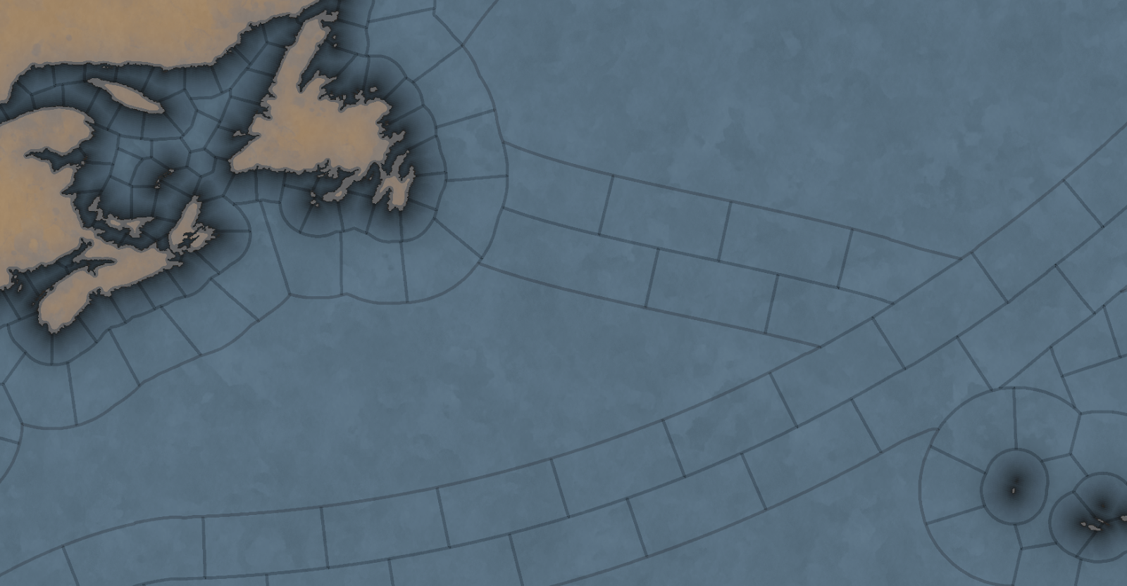
The third is what we call an “impassable wasteland,” which can be used to describe parts of Sahara, Greenland, or other places where hardly any people live even today. We also use these types for the majority of the water covering the oceans.

Finally, we have what we currently call “passages.” These are land locations that can not be settled by anyone, but can still be traversed by an army, with some insanely heavy attrition, or allow trade to pass through. Think of passages across the Saharan desert.

Speaking of desert... In a lot of our games we define each province as having a single terrain value, like Forest, Tundra, or Desert. This is rather limiting because eventually you end up with a huge list of complex things like “Arctic Forested Hill” or “Desert Mountain.” What we have done in Project Caesar is to take a deep look at how we did this in Victoria 2, where we had split terrain into topography and vegetation, and take it further. Now we have 3 different values in each location:

  • Climate - Includes things like Arid, Arctic, Continental, etc.
  • Topography - Flatland, Hills, Mountains etc.
  • Vegetation - Forest, Woods, Farmlands, Desert, etc.

What the actual gameplay impact of these is, we’ll talk about much later… Sorry.

Next week we’ll be back talking about something that could be rather controversial…
 
  • 267Love
  • 183Like
  • 16
  • 9
  • 2Haha
Reactions:
Project Caesar will have a warfare system that involving moving units in locations on the map.
I beg your pardon on this, but I certainly hope that the team handles this well if immersion is indeed one of the pillars for Project Caesar. There is nothing I find less immersive in PDX games than being able to micro-manage armies to the degree of for example EUIV. Not necessarily bad mind you, just not immersive because it is very board game like in my opinion and makes me think of the world in terms of numbers and units and not a living world.
 
  • 8
  • 7
  • 1Haha
  • 1
Reactions:
HOI4 removed certain mustache man making them a shadow in their own nation and later removing the certain flag.
Are you German? Cause that's only censored in the German version because of German laws regarding the use of Nazi iconography, and how Video Games are considered childrens toys legally, and therefore according to law aren't using Nazi iconography in historic concepts (the exceptions made for instance on films or documentaries that might show the same thing).

That's not a woke thing, that's complying with German law. And if you have a problem with that, you should take it up with the Germans.
 
  • 1
  • 1Like
Reactions:
Are you German? Cause that's only censored in the German version because of German laws regarding the use of Nazi iconography, and how Video Games are considered childrens toys legally, and therefore according to law aren't using Nazi iconography in historic concepts (the exceptions made for instance on films or documentaries that might show the same thing).

That's not a woke thing, that's complying with German law. And if you have a problem with that, you should take it up with the Germans.
What you say is essentially correct. But not entirely, as it's outdated.

The German law forbids the depiction of nazi symbols everywhere outside of educational, artistic or scientific context. When Wolfenstein 3D was published there was a decision made and computer games were generally considered as child toys and thus the depiction of these symbols was forbidden in computer games. It was just a decision - no law. However, as noone challenged that decision it was pretty much law-like. And to be frank, why would you, as a game publisher, invest time and money in such a thing? The expected public backlash wouldn't simply be worth it.
Since then game developers were obliged to remove any such symbols form their games if they wnated to enter the German market. Some opted to make a censored German version (like id with Return to Castle Wolfenstein or Paradox with the portraits) and some others opted for simply having no such symbols at all (like Paradox with the symbols and most others). The most used replacement for the Swastika was the Balkenkreuz (which, in a different form, is still in use by the German forces). As for Hitler, it was mostly sufficient to remove his iconic mustache. Anyways, I digress...

Fast forward to 2018: The USK itself now repelled that decision and allows for the depiction of such symbols in video games, albeit on a case-to-case basis. In other terms: To release a game in Germany it has to be reviewed by the USK as they give the age recommendation anyways. Without this recommendation it is generally not allowed to display* these games in public (a fact which is currently making some trouble for some indie devs on Steam). And while giving these recommendations they now also decide whether the depiction of these symbols is "socially adequate".

Since then various games were released in the German market with the depiction of these symbols without any issues.

*It is not forbidden to sell these games. It's just forbidden to display, advertise or to make them publicly available in places where minors may see it. This includes Steam as it has no age confirmation mechanic that would comply to German standards in that regards.

Moderator addition: This does NOT mean that the depiction of these symbols in this forum is allowed!
 
Last edited:
  • 1Like
Reactions:
Wildly OT, but can't be too far as I'm replying to a moderator.

*It is not forbidden to sell these games. It's just forbidden to display, advertise or to make them publicly available in places where minors may see it. This includes Steam as it has no age confirmation mechanic that would comply to German standards in that regards.

How does that work? I can think of the following options.
Steam limits the visibility of games on a country by country basis, so Germans see no stuff that's unacceptable there.
Steam as a whole is banned in Germany.
Steam is available in Germany, and all games are visible there. German developers publishing illegal games get charged, how about foreign ones.

Are there similar issues with other countries? Some possible examples come to mind, but won't speculate on those as that would be current real world politics.
 
Steam limits the visibility of games on a country by country basis, so Germans see no stuff that's unacceptable there.
This.
1710330964333.png


It's nothing new, really. For example pre 2018 it was this what was displayed for Commandos 2 as the Steam version wasn't censored (there existed a censored version on CD when the game was originally released). Now the Steam page for this game is available in Germany.

But you're right, it's OT, we should drop it here.
 
Last edited:
  • 1
Reactions:
Speaking of desert... In a lot of our games we define each province as having a single terrain value, like Forest, Tundra, or Desert. This is rather limiting because eventually you end up with a huge list of complex things like “Arctic Forested Hill” or “Desert Mountain.” What we have done in Project Caesar is to take a deep look at how we did this in Victoria 2, where we had split terrain into topography and vegetation, and take it further. Now we have 3 different values in each location:

  • Climate - Includes things like Arid, Arctic, Continental, etc.
  • Topography - Flatland, Hills, Mountains etc.
  • Vegetation - Forest, Woods, Farmlands, Desert, etc.

I really wish you would go much more deeper into into it. With such detailed map juxtapose modern achievements of geography to make each location geographically flavourful and little bit different from each other. For example you can assign each location a proper Köppen–Geiger climate classification:

Köppen-Geiger_Climate_Classification_Map.png


If agriculture and availability of different plans would be a big think in the new games (as it should) you can go even further assign proper Plant Hardiness Zones to each Location:
World_Hardiness_Zones.png


Then there are soil types:
SoilTypeUE_EEA_en.jpg


And also major drainages (this would also affect the flow of trade):
Ocean_drainage.png


And floristic realms:
41467_2023_38375_Fig1_HTML.png


Then you can assign each location modifiers based on those geographical locations. This could modify things like population growth, agriculture output, autonomy, supply (especially supply for armies from other climate and floristic realm etc).

So you could resign from from manually assigning the vegetation type to a location and just population would be indicator of how much natural landscape was transformed into farmlands. Then, settlement of some locations could be determined by technology. Also this climate, soil, floral borders often explain why border of some empire where one way than another - because keeping some territories would be more expensive than forcefully keeping them. This is my biggest issue with EU4 and this is the reason for the border gore we see - if we control a territory behind a mountains in different drainage basin, with no trade routes connecting and no forts etc., then the autonomy should be constantly ticking up to the point we are not able control the territory. There is a reason why Russian conquered Caucasus so late, why firstly they have to fortify all the passes and why when instability was high then the lands in the Caucasus and behind it were the first to brake away.

Forts should be also very important to secure mountain passes, trade routes etc. and we should be able to fortify locations than functions only as passes even if nobody lives there - the more I invest into infrastructure in an inhabitable pass (forts, roads etc), the more control beyond it I can project.

I really, really wish that the geography was major barrier in blobling... Make snaking expensive, make expansion beyond natural border expensive, make holding some territories not worth holding them. Make forts useful in securing unity of my empire.
 
  • 2
  • 1Love
  • 1
Reactions:
I really wish you would go much more deeper into into it. With such detailed map juxtapose modern achievements of geography to make each location geographically flavourful and little bit different from each other. For example you can assign each location a proper Köppen–Geiger climate classification:

Köppen-Geiger_Climate_Classification_Map.png


If agriculture and availability of different plans would be a big think in the new games (as it should) you can go even further assign proper Plant Hardiness Zones to each Location:
World_Hardiness_Zones.png


Then there are soil types:
SoilTypeUE_EEA_en.jpg


And also major drainages (this would also affect the flow of trade):
Ocean_drainage.png


And floristic realms:
41467_2023_38375_Fig1_HTML.png


Then you can assign each location modifiers based on those geographical locations. This could modify things like population growth, agriculture output, autonomy, supply (especially supply for armies from other climate and floristic realm etc).

So you could resign from from manually assigning the vegetation type to a location and just population would be indicator of how much natural landscape was transformed into farmlands. Then, settlement of some locations could be determined by technology. Also this climate, soil, floral borders often explain why border of some empire where one way than another - because keeping some territories would be more expensive than forcefully keeping them. This is my biggest issue with EU4 and this is the reason for the border gore we see - if we control a territory behind a mountains in different drainage basin, with no trade routes connecting and no forts etc., then the autonomy should be constantly ticking up to the point we are not able control the territory. There is a reason why Russian conquered Caucasus so late, why firstly they have to fortify all the passes and why when instability was high then the lands in the Caucasus and behind it were the first to brake away.

Forts should be also very important to secure mountain passes, trade routes etc. and we should be able to fortify locations than functions only as passes even if nobody lives there - the more I invest into infrastructure in an inhabitable pass (forts, roads etc), the more control beyond it I can project.

I really, really wish that the geography was major barrier in blobling... Make snaking expensive, make expansion beyond natural border expensive, make holding some territories not worth holding them. Make forts useful in securing unity of my empire.
All of that would kill even high end CPUs. Game would be unplayable on average PCs due to extreme lag and performance issues (too many calculations).

Maybe in 2050s for EU 7 ;)
 
  • 1
Reactions:
Not really, because most of this would be static modifiers. Yes, if you would want to simulate climate and weather dynamically it would kill any PC, but I am totally fine with simplifying it some pre-industrial average. If the game starts in the 1300s, there could be just one event modifying climate values around 1430. Or if you want to be more historical to may modify it once every 25 years, but the Little Ice Age started around 1430 and lasted into the industrial age.
 
  • 2Like
  • 1
Reactions:
My concern with these impassable tiles is that we are already losing the authenticity of real exploration. The land tiles are perhaps rightly described this way, but it would still be "nicer" if it was possible to send units and ships into an impassable tile to see if they come out somewhere (let's say about 99% attrition).

This is more important on the high seas, because if the player is "driven" to explore sea currents only, these lose all their strategic value: when in reality the knowledge about the currents was what gave an edge to some countries (at least for some time). But based on the attached map, it seems that the user loses the strategic option of taking much longer to get somewhere though it's safer (think of the French in the Glorious First of June, a battle that took place at what I'd roughly estimate to be unpassable on this map).

Would it not be possible to increase the size of sea locations away from shores but to leave them passable (same kind of size increase rule for adjacent locations as mentioned in the general principles for land locations) and then an explorer may get stuck (and perish!), or if they realize that something helps them go in some direction, then they can move in that direction (and perhaps they won't figure out the way back)?
 
  • 1Like
  • 1
  • 1
Reactions:
Or how to move to EU5 without deterring all « keep eu4 it has more content » fans
I’m super hyped for this game ! 6K hours of eu4 including 1k of modding have made me wanting for new mechanics, more simulation, more province detail, and hopefully more inner interactions (stop Ming and late game countries from boredom)
 
  • 5Haha
  • 1Like
Reactions:
I can see the trade routes from here!
I guess we will have to wait and see for what they actually chose for that but…
Will we finally get circular trade routes based on good demands ?
Ie, in EU4, it’s impossible to mod the full triangular trade
- European send goods to Africa where they are demanded
- African kings / tribe leaders sell their own people or raided people as slaves to Europeans (and make money from it)
European merchants send them to the new world, along with manufactured goods
- they bring back gold, fur and raw products to Europe to manufacture them

- or the Indian Ocean trade
- slaves and ivory are sent by Muslim merchants to india
- the same merchant go back with silk and other manufactured goods from India to Oman / Hormuz

Or in China, where the tradegoods are not only « steered away » by Europeans like in EU4 (as if China did not benefit from anything in return), but as Europeans have to exchange them for gold instead (since China was less interested by European goods). Causing the great depletion of gold in European treasures, the main driver of opening new gold mines in the americas to supply the demand for gold. Or the inrroduction of banknotes to compensâtes for the lower supply.

This would mean that trade would be less of a one way benefit, but I’m more as it really was, an exchange of goods VS goods or goods VS gold. Exchange which did not in itself benefit one or the other (the exchange emerald happened because both shared an interest in trading), but it was more the transport of goods and the added value it generated from one market to the other which was important.

One way to model that, speaking in terms of EU4 system, which I guess would be overhauled anyway, would be represented like this : instead of se find merchants to a tradenode, you would send merchants fleets or caravans to a trade route itself, hereby inflating the amount of « exchange » on the route. The comparative balance of trade power would generate more added value one end or the other of the « link ».

If one link becomes broken (for warfare, pirates, or change in regional demand etc), the link exchange would decrease and move to another link. Ie what happened in history with the fall of the Yuan and the end of the Pax Mongolia, which reverted trade back To the South China Sea and Indian Ocean
 
  • 1
Reactions:
I guess the numerous sea provinces mean : less micromanagement of navies, and more reliance on naval missions such as trade protection, exploration, blockade.
Otherwise i can’t imagine the level of management it would require to move fleet from one small coastal province to another
 
I do really hope that either via MT/Events, or just for moders you will add option of changing vegetation (Forest, Woods, Farmlands, Desert, etc.) of location.

Via huge investment of resources deforesting location to change it into grassland and then farmlands would be great and I was always looking for it in Eu4.
 
  • 1Like
Reactions: