• We have updated our Community Code of Conduct. Please read through the new rules for the forum that are an integral part of Paradox Interactive’s User Agreement.

Victoria 3 - Dev Diary #50 - Living Map

16_9.jpg

Hello again everyone! This week, as promised, I’ll be showing you a lot more of the visual elements of the map and how it evolves over the course of time and through your influence.

The Living Map has many different elements to it that adds both a bit of flavor and life in the world of Victoria 3, I’ll be going over some of the main elements in their current state to give you all some insight.

Hub Expansion
The most important and noticeable aspect that the world is progressing are your Hubs, as you reach certain thresholds of buildings (both production, government and residential ones) your cities will expand with the corresponding buildings. When it comes to the residential buildings they all have three different tiers of wealth within each culture set, the higher tiers are automatically activated upon reaching a higher Standard Of Living for the Pops of that Hub. To further amplify this change of SOL and to provide some more motion around hubs we have an effect that indicates either an increase or decrease with a construction hammer and anvil that either hardens or breaks.

Small Hubs
DD50 01.gif


DD50 02.gif


Large Hubs
DD50 03.gif


DD50 04.gif


Decrease in SOL
DD50 05.gif


Increase in SOL
DD50 06.gif

Vehicles
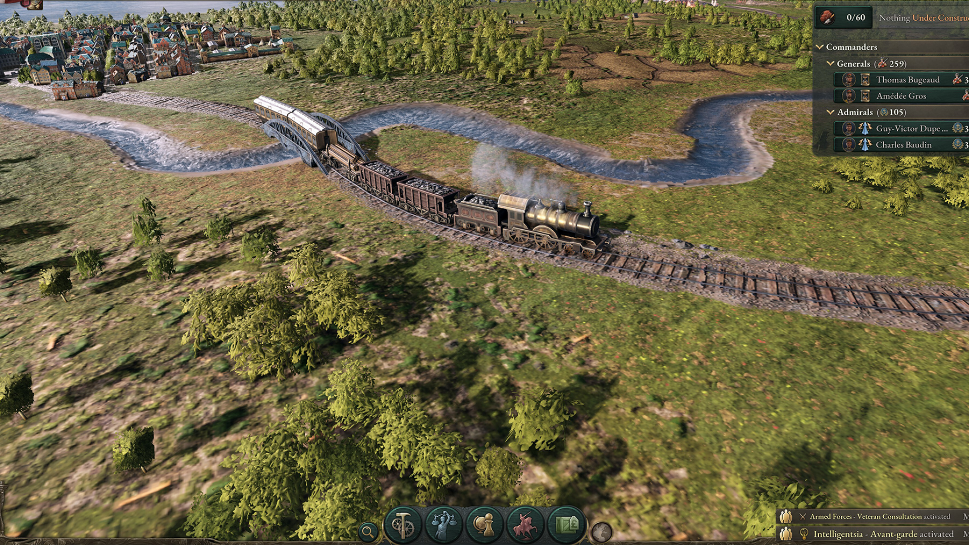
Traversing the roads, seas and even skies of the game we have made quite a few vehicles that breathe life into the world. These are unlocked by research, adjusting your Production Methods and building specific buildings. The most fundamental one being a horse carriage that traverses the dirt roads of connected Hubs, with specific research you can instead have cars putter along the roads! If regular roads are too simple for you there are also a bunch of different trains for when you’ve researched railroads, old locomotives can turn into electric ones and steel railway cars can also be applied.

We’ll get there, eventually
DD50 07.gif


Traveling in style
DD50 08.png


Old locomotive
DD50 09.png


DD50 10.gif


Electric trains
DD50 11.png


DD50 12.gif


DD50 13.gif

But land is not the only place where vehicles make an appearance, in the seas and along the shipping lanes you’ll be able to see cargo ships traveling! These range from simple clippers to steamships, depending on what you’ve researched and what sort of Production Methods you’re utilizing.

Trade ships
DD50 14.png


DD50 15.gif


DD50 16.gif

Last but not least we look to the skies where you’ll be able to see Zeppelins soaring through the air when skyscrapers have been built and act as anchoring points for the massive airships.

Soaring through the skies
DD50 17.gif

Military and War
When conflict inevitably brews and wars break out there are lots of ways we show those effects on your Hubs and surrounding terrain. When gearing up for war your troops will be determined by what you’ve researched and the Production Methods of your Barracks. You can look at what troops you have in your Garrison at any time, but upon entering a battle they (the most advanced unit) will be visible on the map where battle takes place, facing off against the opponents troops. Depending on what weapons you’ve equipped your units with, different effects will show, so even a Mobile Artillery unit has different kinds of shots.

Beautiful illustrations for your troops
DD50 18.png


Bunker fire
DD50 19.gif


Flamethrowers!
DD50 20.gif


Let's play battleship!
DD50 21.gif

When a region has been ravaged by war and a lot of battles you will start to see the effect of that on the region where it has happened through Devastation. The dynamic Devastation affects a variety of parameters for the region, its trade, Pops and Hubs. It also visually shows, not just by tearing up the surrounding terrain but also muddles rivers and burns buildings, the extent of this increases the more battles are fought in the same region.

Devastation (sped up)
DD50 22.gif


Devastation at a Hub
DD50 23.gif

Also, if you really need additional troops you can activate your conscription centers (if you’ve got access to them) which forces a lot of people to sign up. We make sure to show this as well, through an effect on your Hubs where conscripts are being drafted.

Production and Pops
In addition to expanding your city Hubs, you’ll also be able to affect the world with mining, farming and forestry Hubs. Trees will be cut down in close proximity to your forestry Hubs, farms will cultivate the earth and ground will be excavated close to your mines, leaving visible impact on the terrain.

Forestry Hubs and their effect
DD50 24.png


Farm Hubs and their growth
DD50 25.png


Mining Hubs effect on the world
DD50 26.png

With increased production and industrialization within your country and Hubs we are also giving you a purely visual reminder that the world will be affected by that as well. The visual Pollution will see more smokestacks rising from your hubs as well as the surrounding terrain becoming tarnished. All for the sake of progress right?

Smokestacks coming from a Hub
DD50 27.gif


Pollution affecting a larger area
DD50 28.png

However, if your people don't like the way things are progressing they will show their displeasure through turmoil, and if you don’t correctly address their concerns you might find yourself with a revolution on your hands. Turmoil will just be a bit of anger brewing in the form of puffs of displeasure while revolution will have flags of opposition being raised in your hubs.

Let the flags of revolution rise!
DD50 29.gif

Buildings
As previously mentioned, you’ll get zeppelins traversing the skies upon building skyscrapers, and while these behemoths of buildings will tower over the rest in your city Hubs there are still Monuments like the Eiffel Tower that will be even stronger indicators that your cities are growing beyond the point of the regular buildings.

The different skyscrapers for each culture set
DD50 30.png


DD50 31.png


DD50 32.png


DD50 33.png


They also blink!
DD50 34.gif

That should give you all a glimpse into the life of the world map! There are things we would love to explore more in the future but I feel we’ve got a great foundation going that we’d love to hear ideas on how to take further.

Join us next week, where Aron will be covering the tutorial!

 
  • 194Like
  • 165Love
  • 12
  • 11
  • 7
Reactions:
It's not that I don't like it, it's great and I will be running it full graphics on my personal machine. I am just saying I want to be able to mod it out, what if I change it and that representation doesn't make sense anymore? If I can then great but, as far as I understand you can't even mod some of this stuff out of ck3?
 
I basically thinking about something along these lines:

Bunker fire
DD50 19.gif


Flamethrowers!
DD50 20.gif


But much wider and with colorful battle lines like this:
View attachment 852036

PS: This is a really good example because you cant make out any individual soldiers but you instantly know whats going on here and its all done in 2.5d. Also its from COSSACKS 2: BATTLE FOR EUROPE!

PPS: I also think they already use 2D sprites for the battle animations.

PPPS: READY - AIM - FIRE
View attachment 852108

This would be awesome
 
  • 1Like
Reactions:
I've made the conscious to try to steer clear from actual little humans running around, in part due to the already tweaked scale we have for a lot of things in game but also due to the performance cost of animations of non-rigid objects like humans. When it comes to the early era Battle Units each of the 5 cultures will have their own lowest tier of infantry that are more or less civilian buildings used as cover for basic weapons.
Please reconsider this, seeing infantry fighting might seem like a small detail but it plays a huge part in how easy it is to immerse yourself in the period. Seeing the uniforms and human level dose a lot to make the game more than a map on a screen.

Likewise, warfare is already quit a departure from typical pdx games and for me this is more important than the micro/macro arguments.
 
  • 5
  • 3
Reactions:
Please reconsider this, seeing infantry fighting might seem like a small detail but it plays a huge part in how easy it is to immerse yourself in the period. Seeing the uniforms and human level dose a lot to make the game more than a map on a screen.

Likewise, warfare is already quit a departure from typical pdx games and for me this is more important than the micro/macro arguments.
Maybe for you. But for others, seeing the units on the map is a big distraction from the more important things on the map and breaks immersion because of the necessarily oversized people running around. That seems like it will especially be the case with the new warfare system where there is no longer a need to physically show a unit is in a specific location at all times and there's only a need to show that a battle is occurring, which can be done well with the buildings only. Unit sprites and models were already mostly a frivolous cosmetic element in previous Paradox games, and now they are even more so. With such a big departure from strategy game conventions, it's better to have a full break departure from previous games and create what is best for the new system than be held back by clinging to a few of the old conventional habits that hurt the new system.
 
  • 6
  • 3
  • 1Like
Reactions:
Maybe for you. But for others, seeing the units on the map is a big distraction from the more important things on the map and breaks immersion because of the necessarily oversized people running around. That seems like it will especially be the case with the new warfare system where there is no longer a need to physically show a unit is in a specific location at all times and there's only a need to show that a battle is occurring, which can be done well with the buildings only. Unit sprites and models were already mostly a frivolous cosmetic element in previous Paradox games, and now they are even more so. With such a big departure from strategy game conventions, it's better to have a full break departure from previous games and create what is best for the new system than be held back by clinging to a few of the old conventional habits that hurt the new system.

*Diplomatic play intensifies*
 
  • 4Haha
  • 1Like
Reactions:
Maybe for you. But for others, seeing the units on the map is a big distraction from the more important things on the map and breaks immersion because of the necessarily oversized people running around. That seems like it will especially be the case with the new warfare system where there is no longer a need to physically show a unit is in a specific location at all times and there's only a need to show that a battle is occurring, which can be done well with the buildings only. Unit sprites and models were already mostly a frivolous cosmetic element in previous Paradox games, and now they are even more so. With such a big departure from strategy game conventions, it's better to have a full break departure from previous games and create what is best for the new system than be held back by clinging to a few of the old conventional habits that hurt the new system.
Well yeah that was the point of my post, for me that is important. I think a majority of players will agree that a line of flame and six cannons shooting over it is hardly a ‘full break’ from the old system. Moreover, one of the biggest advantages of the new system, as you said, is that you don’t need to interact or click on units. They could show somthing that accurately depicts a battle not just giant men.

In fairness I can see your point in that the moving lines might provide enough engagement to be interesting enough but that’s somthing that I’d need to see in game to decide on. Oat the moment it seems more a strange half-way point, of which I’d personally prefer leaning more into more varied and interesting visual combat.
 
  • 3
Reactions:
In the 1800s military planners both at the Nation's Capital and in the field, often had map tables on which they placed figures -- what we call miniatures today -- to represent units positioned on the field of battle. They moved them around as reports from the front came in. On the field level they were individual units under a single command; at the strategic level they represented larger formations and their type.*

It doesn't need to be prettily uniformed soldiers, although that would be nice, a Risk Army block would work just as well. It could be a tent, or just a colored disk. I would like to be able to see where in the world my armies are located. If for no other reason, the ability to see about how far and how long an army could travel to get where I want to send it.

Abstracting combat based on the quantity, quality, and equipment level is what all games do, really. With formation construction added into the formula we don't get/need to maneuver units, and I think that might be a good thing. But an army is not a nebulous thing that is somewhere/everywhere in my territory; it has a physical location and that should somehow be marked.

*Okay, in the field they weren't always up to date since they were busy at the time.
 
  • 2
  • 1
Reactions:
In the 1800s military planners both at the Nation's Capital and in the field, often had map tables on which they placed figures -- what we call miniatures today -- to represent units positioned on the field of battle. They moved them around as reports from the front came in. On the field level they were individual units under a single command; at the strategic level they represented larger formations and their type.*

It doesn't need to be prettily uniformed soldiers, although that would be nice, a Risk Army block would work just as well. It could be a tent, or just a colored disk. I would like to be able to see where in the world my armies are located. If for no other reason, the ability to see about how far and how long an army could travel to get where I want to send it.

Abstracting combat based on the quantity, quality, and equipment level is what all games do, really. With formation construction added into the formula we don't get/need to maneuver units, and I think that might be a good thing. But an army is not a nebulous thing that is somewhere/everywhere in my territory; it has a physical location and that should somehow be marked.

*Okay, in the field they weren't always up to date since they were busy at the time.

I imagine that would work really well when zoomed out to the paper map level; and then, incorporate the animated models when zoomed into the living map level?
 
This looks very amazing! I really like! A live map is what you need) I hope that in the future we will see power lines that will cut through your states, hydroelectric power stations, reservoirs, expanding river basins, oil pumps.