• We have updated our Community Code of Conduct. Please read through the new rules for the forum that are an integral part of Paradox Interactive’s User Agreement.
I'm not sure, that's why I presented it only as an option. The Norse were familiar with wine, though, and going by their sagas quite fond of getting drunk, so it could be a "land where there's good drink to be had." In any case the grapes and the name Vinland have been much discussed, both separately and together. Even in the Medieval Warm Period Newfoundland is too far north for actual grapes and wine, so if they're literal then we must look further south, if they're metaphorical, then maybe not.
The Greenlanders' Saga goes into detail about how they are actually finding grapes on a landmass south of Labrador, that they make Leif Erikson's German foster father who knows what grapes are drunk, and that this is why Leif Erikson named it Vinland:
At first, Tyrker spoke for some time in German, rolling his eyes, and grinning, and they could not understand him; but after a time he addressed them in Norse: ‘I did not go much further [than you] but I have news to relate. I have found vines and grapes.’ ‘Is this true, foster-father?’ said Leif. ‘I’m certain,’ he said, ‘because I was born where there is no lack of either grapes or vines.’ They slept through the night and the next day, Leif said to his shipmates: ‘We will now divide our labours, and each day we’ll either gather grapes or cut vines and fell trees, in order to obtain a cargo of these for my ship.’ They acted upon this advice, and it is said that the boat they dragged behind the ship was filled with grapes. A cargo sufficient for the ship was cut, and when the spring came, they made their ship ready and sailed away; and from its products Leif gave the land a name, and called it Vinland.

I read assertions online that grapes grew in Newfoundland in the Vikings' time, but don't know if that was the case.
 
This method looks good. Also, one should compare archaeology as well - and the biases of the other sources that you're reading. The sagas are biased in favor of the Norse, but the Anglo-Saxon chronicles, for example, are biased against them. Just because something is mentioned in the sagas and not in the chronicles doesn't mean that it's untrue - especially if it describes the Norse as heroic (why would the Anglo-Saxons portray their enemies heroically?).

As such, Ragnar (or his inspiration) being from the 9th century makes more sense than being from the 5th century. It's also possible that he was a composite character between a 9th century king and a 5th century chieftain, I guess. If so, though, the king would've inspired most of the legendary character... Other than the Aslaug thing, the timing is mostly consistent.
Don't make too much of it, it wasn't meant to be exhaustive. I though Wagonlitz was making some very basic mistakes, so I thought to provide a sort of beginner's guide to textual criticism, that's all.
 
  • 1Like
Reactions:
Just stumbled across this discussion recently and it is a fascinating read: like listening to an in-person intellectual debate with many interesting tangents. So good to see this from some history experts.
Personally, too new to researching the Norse to add to this presently, but I had to express some gratitude from a reader's perspective.
Also, very much appreciate the recent map postings from @rakovskii which clearly show I live in Vinland.
 
Last edited:
  • 1Love
  • 1Like
Reactions:
not sure, that's why I presented it only as an option. The Norse were familiar with wine, though
Wine making wasn't viable in Denmark until 10 to 15 years ago. Unless I'm very misremembering then even at the height of the medieval warming, which is a couple centuries after Vinland was discovered, it wasn't as warm here as it is now.

So I'm extremely skeptical of claims of grapes being grown here. And it was mead people drank in general, as well as beer.

Doesn't mean they didn't know grapes or wine from either traveling south or trading of course.
The current growing range for Canada's and the US's native wild grapes is below, and I've seen assertions online that south Newfoundland had wild grapes in the Viking Age but that north Newfoundland did not. Maybe if you showed the Vikings the map below, they would think that "Vinland" ranged from south Newfoundland or Nova Scotia to Kansas.
Honestly, looking at that map, I'd rather think it'd be Nova Scotia than New Foundland, as why are there no grapes there now if they were there then? I'm aware there was the little ice age in between, but they'd have had to get there originally before the viking times, so why aren't they there again now?

Note, I'm no expert at all on New Foundland climate so could be there's a good explanation. I'm just a tad skeptical about grapes being claimed to be there in viking times, when they're not there today.

Adam of Bremen's Gesta Hammaburgensis Ecclesiae Pontificum (Deeds of Bishops of the Hamburg Church), written circa 1073-1076, says:
What does unsown grain refer to? Wild grain, or perhaps New types of grain?
And I do wonder if the unsown grain descriptions were influenced by some of rhe myths talking about unsown grain in Asgard. Makes me wonder whether the vikings ever suspected some of their far off discoveries might have been Asgard. Do we have any idea whether they did?

Wagonlitz was making some very basic mistakes, so I thought to provide a sort of beginner's guide to textual criticism, that's all.
What basic mistakes did I make?
I'm legit curious.
As all I did in that post you quoted was ask if there could be earlier parts for Ragnar, as I'm not an expert on that so mostly just threw an idea ok the board, and then pointed out there there was a change in élite around 200 AD.

And again around 550 AD, actually. That one I have a little pet theory of being the cause of the Fimbulwinter and hence possibly where the myth of ragnarok originated.
Though, that's not for this thread.
 
  • 1Like
Reactions:
Wine making wasn't viable in Denmark until 10 to 15 years ago. Unless I'm very misremembering then even at the height of the medieval warming, which is a couple centuries after Vinland was discovered, it wasn't as warm here as it is now.

So I'm extremely skeptical of claims of grapes being grown here. And it was mead people drank in general, as well as beer.

Doesn't mean they didn't know grapes or wine from either traveling south or trading of course.
Exactly.

What basic mistakes did I make?
I'm legit curious.
As all I did in that post you quoted was ask if there could be earlier parts for Ragnar, as I'm not an expert on that so mostly just threw an idea ok the board, and then pointed out there there was a change in élite around 200 AD.

And again around 550 AD, actually. That one I have a little pet theory of being the cause of the Fimbulwinter and hence possibly where the myth of ragnarok originated.
Though, that's not for this thread.
The ones I explained in that previous post. I'm sorry, I don't have the energy to go over them again.
 
  • 1Like
Reactions:
~ Dreaming of Bar Harbor ~
I had a dream about 5 years ago that I was on a rocky seashore and a group of people were calling me that their boat was leaving soon, like to Europe. I got a place-name in my head during the dream: "Bar Harbor." The next day, I was reading online about Viking relics in Maine, and came across the "Maine Penny." It's practically the only Viking relic in New England that mainstream academia agrees is authentic. The article said that it was found at "Bar Harbor." Within about a week, my parents decided to take me on a trip to New England for a couple days for their work conference in southern New England. We stayed up to about a week in Bar Harbor Maine.

I didn't recall specifically hearing of "Bar Harbor" before my dream. If you had asked me before I read about the Maine Penny, I would have said that I don't know what that place is. The "Maine Penny" wasn't actually found in Bar Harbor, it was found in a the remains of a medieval Amerindian settlement Brooklin, Maine to the west of a fjord across from Bar Harbor. My parents said that they wanted to visit Bar Harbor because of Acadia National Park's natural beauty. I don't recall telling my parents about Bar Harbor before the trip. Technically, we didn't stay in Bar Harbor, we stayed in Ellsworth to its north because we got a cheaper hotel. But we spent our time practically visiting places on Bar Harbor. Bar Harbor and Portland, Maine are the two embarkation points for the ferry to Yarmouth, Nova Scotia.

Y2RhM2MzX2IuanBn.jpg

"The coast of Mount Desert Island, not far from the Goddard Site." Source: https://www.atlasobscura.com/articles/maine-norse-penny-archaeology-vikings-north-america
Goddard was the property owner's name. The picture above resembles the rocky coast in my dream.


b2luIGNyb3AuanBn.jpg

The Maine Penny

LmpwZw.jpg

Above are coins discovered in Gressli, Norway in a collection known as the "Gressli hoard."
 
  • 1Like
Reactions:
Wine making wasn't viable in Denmark until 10 to 15 years ago. Unless I'm very misremembering then even at the height of the medieval warming, which is a couple centuries after Vinland was discovered, it wasn't as warm here as it is now.

So I'm extremely skeptical of claims of grapes being grown here.

It looks like you are right in a general sense, that grapes weren't typically grown in Denmark. On the other hand:
Two grape pips were unearthed near Lake Tissø by Peter Steen Henriksen, an archaeological botanist and museum curator at the National Museum of Denmark based in Copenhagen. After they were analysed, one was dated to the Iron Age and the other to the Viking period. Prior to this discovery no additional evidence of grapes before the Middle Ages is known. Furthermore, subsequent strontium isotope tests on the Viking Age grape pip at the National Museum showed that the grape in which it originated was likely grown on the island of Zealand, Denmark. It is not exactly known yet how the two grapes were used back then, but it is very likely that they were integrated in winemaking,
"Danish Vikings Could Have Produced Their Own Wine Domestically,"
In any case, the Greenlanders' Saga goes into detail about how a German among the Vikings discovered that the grapes in Vinland were actual grapes because he was familiar with real grapes himself from climate areas in Europe warm enough for grapes.


Honestly, looking at that map, I'd rather think it'd be Nova Scotia than New Foundland, as why are there no grapes there now if they were there then? I'm aware there was the little ice age in between, but they'd have had to get there originally before the viking times, so why aren't they there again now? Note, I'm no expert at all on New Foundland climate so could be there's a good explanation.
This is a tricky issue because grapes grow wildly in an axis running in a southwest curve around the St Lawrence Gulf, from Anticosti island in the west to Nova Scotia in the east, but Newfoundland is not included in that curve and does not have wild grapes today. On the other hand, writers on the topic note that people visiting southern 17th century Newfoundland were reporting grapes growing there wildly - I found at least one quote to that effect. One possibility is that what the 17th century explorers were calling grapes were not actual grapes. What I saw online about this was:

"...blueberries resemble certain varieties of grapes - although they do not grow on vines. A second possibility is that wild grapes did grow there during the Medieval Warm Period, when temperatures were higher than those of today."
Michael Allaby, "Exploration," p. 50.

At the end of the season I went by boat to Cape Broyle [at the east end of Newfoundland], to Caplin Bay [at the east end of Labrador], to Ferryland [at the east end of Newfoundland], and home. Here are beaver, otter, and deer plentiful; for fruits, strawberry, raspberries, whorts [blueberries], and wild grapes incredible.
James Yonge; 1663, Extract from "A journal of all the memorable occurances [sic] of my life", James Yonge; 1663

Wild grapes too are found on the west coast of Newfoundland, according to Anspach;
and in 1521 the Portuguese colonists in Cape Breton sent word home that among the products of that country were grapes. The writer of this paper has tasted some excellent wine made by a relative living at Fredericton, New Brunswick, from the wild grapes that are so be seen hanging in clusters from the elm-trees on the intervale lands along the St. John River.
R.G. Haliburton, "Lost Colonies of Northmen and Portuguese." The Popular Science Monthly, Volume 27, 1885


"Adam of Bremen's Gesta Hammaburgensis Ecclesiae Pontificum (Deeds of Bishops of the Hamburg Church), written circa 1073-1076, says: ..."

What does unsown grain refer to? Wild grain, or perhaps New types of grain?
And I do wonder if the unsown grain descriptions were influenced by some of rhe myths talking about unsown grain in Asgard. Makes me wonder whether the vikings ever suspected some of their far off discoveries might have been Asgard. Do we have any idea whether they did?
Some modern scholars suggest that a type of wild grain-grass native to the St Lawrence Bay area was what the Vikings were identifying as grain. One writer gave a Latin name for this type of grass.

Here is one writer's interpretation in his endnote:
There were self-sown wheat[25-3] fields and vines growing there. There were also those trees there which are called "mausur,"[25-4] and of all these they took specimens.

ENDNOTES:
[25-3] A wild cereal of some sort. Fiske is convinced that it was Indian corn, while Storm thinks it was wild rice, contending with much force that Indian corn was a product entirely unknown to the explorers, and that they could not by any possibility have confused it with wheat, even if they had found it. There is, moreover, no indication in this saga that they found cultivated fields. Storm cites Sir William Alexander, _Encouragement to Colonies_ (1624), who, in speaking of the products of Nova Scotia, refers, among other things, to "some eares of wheate, barly and rie growing there wild." He also cites Jacques Cartier, who, in 1534, found in New Brunswick "wild grain like rye, which looked as though it had been sowed and cultivated."
[25-4] Supposed to be maple.

SOURCE: The Saga of Eric the Red, in "The Northmen, Columbus and Cabot, 985-1503"

I have also seen modern writers interpret the "grain" in the Sagas interpreted to mean the corn that the Amerindians grew. However, corn is not really a wild plant in the full sense of the word, but rather domesticated. It has evolved or adapted to a point after centuries of cultivation whereby it needs to be farmed in order to grow successfully for long. By the way, in the Greenlanders' Saga, the Vikings explore the islands off the western coast from Leif's camp and find a building for storing "grain".

The self-sown what was long itnerpreted as Indian Corn, but in recent years the theory advanced by Schubeler has been generally adopted, that the What (hveiti) seen by the Norsemen in Vinland was the American Wild Rice (Zisania).... there are, among the more than two hundred indigenous grasses which are found near the coast from New England northward, ten [footnote 2 for the Latin list] or more species which in superficial aspect are closely similar to the true Wheat (Triticum vulgare). Of these ten or more native grasses the species of Agropyron demand bried discussion, for by many authors they are untied with Triticum, the true Wheat; and in modern works upon the Norwegian and Icelandic floas they bear the name Hvede.

NOTES ON THE PLANTS OF WINELAND THE GOOD
M. L. Fernald, Rhodora, Vol. 12, No. 134 (February, 1910), pp. 17-38 (22 pages)

I never have seen Asgard coming up as something in the Sagas that the Vikings that they had reached when they visited Vinland. The account of the Uniped attacker, one scholar noted, correlates with known ancient or medieval European theories about what people were like who lived at the edges of the known world. It doesn't mean in those theories necessarily that people believed that the world was flat, though some people apparently did believe that the world was flat. Rather, ancient and medieval scientists were able to theorize that the world was a round globe, and they theorized about what people were like who lived in the as-yet undiscovered parts of the globe.
 
Last edited:
  • 1
Reactions:
The ones I explained in that previous post. I'm sorry, I don't have the energy to go over them again.
Rereading it again then it seems that what you claimed mistakes was misreading what I had written. I didn't claim that Ragnar had to live earlier or descend from Skjold. Just brought up that perhaps it could be the case, but that I didn't know how it fit the sources.

Also, as was mentioned by Rakovskii, then there aren't really any "real" historical sources. The various chronicles e.g. in England can be just as much legend as some of the Norse ones, especially when talking about past events.
And for current events, then as was pointed out the Norse would have a positive bias, the Anglo-Saxons a negative bias. And hence teh truth probably would be somewhere between what the two says, for events that both cover.
It looks like you are right in a general sense, that grapes weren't typically grown in Denmark. On the other hand:
Wasn't aware of that. I do doubt that it ever was large scale, though.
Yes, you probably always have been able to grow some grapes here and there, but given it only now became viable, then I doubt it was viable back then. Doesn't mean you can't have had some local conditions allowing for a single vine or two.

Also, I'm skeptical about those strontium analysies honestly, after all the Egtved girl debacle and how a lot of very reasonable doubt was raised about that strontium analysis, but the researchers refused to listen.
(I'm not an expert, and it was years ago, so I can only remember the main points. But the main points were about how strontium levels have massively changed over time from farming, and that that also seems into neighbouring areas, etc. and hence you can't just compare modern day levels with old finds, like they did for the Egtved girl. Whether or not the criticism was valid I don't know, as I'm no expert, but I did follow the long articles on it and there was a lot of people unable to agree. And as mentioned the researchers behind the paper that started the discussion refused to really go into it when countered with counter arguments, so that does make me skeptical of this too.)

This is a tricky issue because grapes grow wildly in an axis running in a southwest curve around the St Lawrence Gulf, from Anticosti island in the west to Nova Scotia in the east, but Newfoundland is not included in that curve and does not have wild grapes today. On the other hand, writers on the topic note that people visiting southern 17th century Newfoundland were reporting grapes growing there wildly - I found at least one quote to that effect. One possibility is that what the 17th century explorers were calling grapes were not actual grapes. What I saw online about this was:
Who knows, perhaps it was blue berries. American blueberries are quite different from European ones, from what I've been told, so could be that they weren't recognised as blueberries, but rather thought of as grapes.
Do American blueberries look like grapes?

I have also seen modern writers interpret the "grain" in the Sagas interpreted to mean the corn that the Amerindians grew. However, corn is not really a wild plant in the full sense of the word, but rather domesticated. It has evolved or adapted to a point after centuries of cultivation whereby it needs to be farmed in order to grow successfully for long. By the way, in the Greenlanders' Saga, the Vikings explore the islands off the western coast from Leif's camp and find a building for storing "grain".
Did I read that correctly in tha tit stated that the various grasses that are suspects were called wheat in Norwgian and Icelandic in 1910, or was it that Norwegian and Icelandic just called it wheat when publishing the sagas?

It doesn't mean in those theories necessarily that people believed that the world was flat, though some people apparently did believe that the world was flat. Rather, ancient and medieval scientists were able to theorize that the world was a round globe, and they theorized about what people were like who lived in the as-yet undiscovered parts of the globe.
Pretty sure that Norse cosmology had the Earth be flat. With the various World's being in different parts of the entire "world body", with the sky being a sphere (Ymer's skull).
Afaik then the most common belief was that the various world's were inconcentric circles, with the innermost circle being Asgård, though I've also seen versions where the various parts are placed in different places around the World with the World Sea ground around, and a huge "bay" separating Asgård and Vanaheim and Midgård being at the bottom of the bay. That version also fits with how Udgård generally is said to be Østerled, i.e. in the East, and hence not as a circle around everything.
Though, as with everything in Norse mythology, then there's various contradictions between sources.

I've not seen any sayuing the World isn't flat, though, so I think it's safe to say they did think of the World as being flat.
Though, perhaps there are sources where they state it's not flat, but if so then I'm not aware of them.
 
Rereading it again then it seems that what you claimed mistakes was misreading what I had written. I didn't claim that Ragnar had to live earlier or descend from Skjold. Just brought up that perhaps it could be the case, but that I didn't know how it fit the sources.
You can put a "perhaps" in there but it's still a suggestion you make, and it's mistaken.

Also, as was mentioned by Rakovskii, then there aren't really any "real" historical sources. The various chronicles e.g. in England can be just as much legend as some of the Norse ones, especially when talking about past events.
And for current events, then as was pointed out the Norse would have a positive bias, the Anglo-Saxons a negative bias. And hence teh truth probably would be somewhere between what the two says, for events that both cover.
That works for things like how many people died in a battle, or how heroic or cowardly each party behaved. It does not work for fitting elements of a story to chronology. If you have one data point that fits Attila and another that fits Charlemagne, you have zero data points that fit a date in the middle.
 
  • 1Like
Reactions:
Technically the cosmology said that the world was a tree. Regardless, the other Europeans knew it was round, so the Vikings could've known about the idea from trading, even if it was contradicted religiously (especially since there were Vikings that outright hated the gods).

Comparing sources is generally a good idea, but, yeah, the only evidence for a "Ragnar actually lived in the Migration Period" theory is his saga... and he's mentioned nowhere else in Europe, unlike other historical and legendary figures from that period (Theodoric the Great/Dietrich, Attila himself, the Volsungs...). Also, archaeology is the only confirmation.

The Maine Penny doesn't guarantee that the Vikings visited the area. Trade could easily explain it (Vikings trade with Newfoundland natives, then Newfoundland natives trade with Maine natives). It's actually weird that Viking coins aren't spread out more across the Americas because of this (which supports a theory that any settlements didn't last long).
 
  • 1Like
Reactions:
Wasn't aware of that. I do doubt that it ever was large scale, though.
Yes, you probably always have been able to grow some grapes here and there, but given it only now became viable, then I doubt it was viable back then. Doesn't mean you can't have had some local conditions allowing for a single vine or two.

Also, I'm skeptical about those strontium analysies honestly, after all the Egtved girl debacle and how a lot of very reasonable doubt was raised about that strontium analysis, but the researchers refused to listen.
(I'm not an expert, and it was years ago, so I can only remember the main points. But the main points were about how strontium levels have massively changed over time from farming, and that that also seems into neighbouring areas, etc. and hence you can't just compare modern day levels with old finds, like they did for the Egtved girl. Whether or not the criticism was valid I don't know, as I'm no expert, but I did follow the long articles on it and there was a lot of people unable to agree. And as mentioned the researchers behind the paper that started the discussion refused to really go into it when countered with counter arguments, so that does make me skeptical of this too.)
That makes sense.

Who knows, perhaps it was blue berries. American blueberries are quite different from European ones, from what I've been told, so could be that they weren't recognised as blueberries, but rather thought of as grapes.
Do American blueberries look like grapes?
I am eating a fruit salad with both American blue berries and native American red-purple grapes from a garden on the same spoon, and they look different enough to me in terms of color, size, texture, stem. Blueberries grow on bushes; native grapes grow on vines. Blueberries are blue, juicy, and sweet, wild native grapes are tart and have seeds and a tough skin.
blueberries_annotated2-0ab902955b674c2a9af28d94d654cd06.jpg


Wild American grapes like those on my spoon:
esic_black_muscadine.jpg


Unlike blueberries though, wild American grapes seem to have come in a variety of appearances, and when I look at photos of wild American grapes online where they are not close up, some of them remind me of blueberries in the photos.

But the issue is whether the 17th century EUROPEAN explorers could have looked at American blueberries and confused them with EUROPEAN grapes though. so whether AMERICAN grapes look like American blueberries is less relevant.

Bilberry-wild-blueberry-cultivated-blueberry-difference-vaccinium-angustifolium.jpg


I think that if Europeans put American grapes and American blueberries in their mouth, they would be able to tell the difference. American blueberries are pretty yummy IMO and work well in cakes and pies and oatmeal and pancakes, etc.
American wild grapes are relatively unpopular for straight eating and selling in grocery stores IMO because of how tart they are, how tough their skin is, the crunchiness of their seeds, etc. Actually, they really are OK to eat and not BAD, just not as good as Blueberries or as good as big sweet juicy yellow-green grapes. American wild grapes work well in winemaking.

blueberry-pancakes-2.jpg

Blueberry pancakes are popular in the US.


But anyway, actually Yes, I can imagine that a European sailor from a city some place in England who is no specialist in world fruits could come to Canada and look at blueberries or some other kind of berry and think that he is looking at "grapes." Maybe the explorer even used "grapes" in some loose sense; Colonial Europeans had a special kind of cannon projectile that they called "grape shot" because it was made up of pieces.
We do have more than one colonial European source claiming to have seen "grapes" in Newfoundland though. The one English sailor whom I quoted from the 17th century saw them in eastern Newfoundland, whereas another modern scholar who I quoted said that they were were reported in western Newfoundland. So it seems to me that there were grapes there then, even though it's not totally proven.

On one hand, since grapes grow in Nova Scotia and can be artificially cultivated in Newfoundland, it seems realistic that 500-1000 years ago there were these kinds of grapes also in Newfoundland.
On the other hand, the Vikings talk about trawling away big cargoes of grapes, and they called the land "Vinland", as if it were Wine-land or Grape-land. If you saw tons of grapes in Nova Scotia and just scattered grapes in Newfoundland, you still might be more inclined to think of Nova Scotia as a "Grapeland." My point is that even if Grapes literally grew in both spots (Newfoundland and Nova Scotia), the grapes in Nova Scotia could still be more impressive and thus more likely to attract the Vikings as a "Vineland."


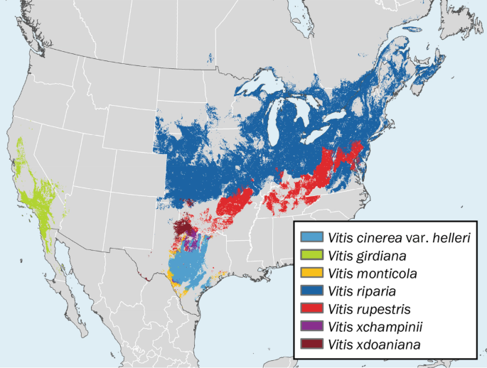
This kind of issue comes up with the discovery of Butternuts at L'Anse aux Meadows too, @Wagonlitz.
That is, we found butternuts at the Viking site in northern Newfoundland, so we can conclude that they certainly visited and camped in some place in Canada or the US with Butternuts, and this gives us 4 of the most northeastern locations:
A) A small area of the upper Miramichi River near Doaktown that flows into the St. Lawrence River
B) A large area of the St. John's River Valley, New Brunswick, that flows into the Bay of Fundy.
C) A big area of New England west of central Maine
D) A moderate area of Quebec, starting with the Quebec City area and going southwest along the St. Lawrence River Valley.

Butternut map of NB.jpg

The patch below the W in "New Brunswick" in the map above is in the Doaktown area of the Miramichi River that flows into the St. Lawrence Gulf.
The rest is in the basin that flows into the Bay of Fundy.

On one hand, Option A) The Miramichi River Valley would be the quickest target option for the Vikings to get to. BUT the collection of butternuts there is much smaller than in Options B to D, which calls into major question whether the VIkings followed Option A to get the Butternuts. Plus, the Doaktown area of the Miramichi River is a narrow tributary and maybe 25 miles upriver from the main trunk and fork part of the Miramichi River where it would be easy for the Vikings to sail to.

The underlying issue in both cases (Newfoundland grapes and Miramichi butternuts vs. Nova Scotia Grapes and St. John butternuts) is whether the Vikings would be more likely to find and gather and focus on these fruits based on proximity to their proven location in L'Anse aux Meadows, or to find and gather them based on the giant quantity of the target resources farther away from Newfoundland.

Do you see what I mean?

Did I read that correctly in tha tit stated that the various grasses that are suspects were called wheat in Norwgian and Icelandic in 1910, or was it that Norwegian and Icelandic just called it wheat when publishing the sagas?
What country are you from, may I ask?

I think that you are talking about this quote:
The self-sown what was long itnerpreted as Indian Corn, but in recent years the theory advanced by Schubeler has been generally adopted, that the What (hveiti) seen by the Norsemen in Vinland was the American Wild Rice (Zisania).... there are, among the more than two hundred indigenous grasses which are found near the coast from New England northward, ten [footnote 2 for the Latin list] or more species which in superficial aspect are closely similar to the true Wheat (Triticum vulgare). Of these ten or more native grasses the species of Agropyron demand brief discussion, for by many authors they are united with Triticum, the true Wheat; and in modern works upon the Norwegian and Icelandic floras they bear the name Hvede.

NOTES ON THE PLANTS OF WINELAND THE GOOD, M. L. Fernald, Rhodora, Vol. 12, No. 134 (February, 1910), pp. 17-38 (22 pages)

The quote above says:
  • 10 or more kinds of American wild grasses look somewhat like actual, true wheat (Latin name Triticum vulgare), but they are not actually true wheat.
  • Many authors unite these 10+ American grasses with "true Wheat"
  • In modern writing about Norwegian and Icelandic plants, these 10+ American wild grasses are called "Hvede". ("Hvede" is the Danish word for wheat.)

Grano.png

The picture above is true wheat, "Triticum vulgare."

So in conclusion, the 1910 book is not directly asserting that "Norwegian and Icelandic just called it wheat when publishing the sagas."
But the 1910 book is suggesting as a possibility that the medieval Scandinavian writers "just called it wheat when publishing the sagas".

Pretty sure that Norse cosmology had the Earth be flat. With the various World's being in different parts of the entire "world body", with the sky being a sphere (Ymer's skull).
Afaik then the most common belief was that the various world's were inconcentric circles, with the innermost circle being Asgård, though I've also seen versions where the various parts are placed in different places around the World with the World Sea ground around, and a huge "bay" separating Asgård and Vanaheim and Midgård being at the bottom of the bay. That version also fits with how Udgård generally is said to be Østerled, i.e. in the East, and hence not as a circle around everything.
Though, as with everything in Norse mythology, then there's various contradictions between sources.

I've not seen any sayuing the World isn't flat, though, so I think it's safe to say they did think of the World as being flat.
Though, perhaps there are sources where they state it's not flat, but if so then I'm not aware of them.
OK. For purposes of the topic of the "One-Footer," what I read as one modern explanation of the Saga was that some medieval Europeans theorized that one kind of people living at the edge of the known world were "One-footers." In the modern Explanation, the Saga writer was either talking about a real literal event with a literal "one-footed" attacker, like on a crutch or peg-leg, or else the writer was adding the medieval theme of a "One-Footed" inhabitant of the world's edge into his Saga, without there being a literal "Uniped" person encountered.

Here is evidence for another reasonable explanation:
John of Marignolli (1338–1353) provides another explanation of these creatures. Quote from his travels from India:[13]

The truth is that no such people do exist as nations, though there may be an individual monster here and there. Nor is there any people at all such as has been invented, who have but one foot which they use to shade themselves withal. But as all the Indians commonly go naked, they are in the habit of carrying a thing like a little tent-roof on a cane handle, which they open out at will as a protection against sun or rain. This they call a chatyr; I brought one to Florence with me. And this it is which the poets have converted into a foot.
— Giovanni de' Marignolli

That is, Europeans could have seen people in India or in Canada with a long stick and could have called the stick a single "leg" or "foot." So the original European narrators of such accounts could have referred to people with a long single leg, but they could have actually meant the stick by the "leg," instead of meaning that the person was missing one of humans' normal two legs below his waist.
 
You can put a "perhaps" in there but it's still a suggestion you make, and it's mistaken.
I wasn't making statements about it being teh case.
I was literally asking if it could be, as I didn't know. Literally raising the possibility. That doesn't mean I was claiming it was the case.

That works for things like how many people died in a battle, or how heroic or cowardly each party behaved. It does not work for fitting elements of a story to chronology. If you have one data point that fits Attila and another that fits Charlemagne, you have zero data points that fit a date in the middle.
I did say that I get Ragnar and Atilla weren't contemporary.
I was talking about general things. And you can't just trust an Anglo-Saxon source more on how heroic or cowardice a party was. They'll have just as much bias on that as the Norse source.

Technically the cosmology said that the world was a tree
Isn't the tree just in the centre of things and reachign into all world's, but the world still beingt made from Ymer's body and the sky from his skull?

the other Europeans knew it was round
European scholars knew. Did the general population?

It's actually weird that Viking coins aren't spread out more across the Americas because of this (which supports a theory that any settlements didn't last long).
Did the natives actually treasure gold and silver as much as in Europe? Like, IIRC then gold was treasured less in e.g. the Andes and Mesoamerica due to it's abundance. So if other stuff generally was used for trading then perhaps silver coins just aren't too interesting.
 
  • 1Like
Reactions:
Seeing that European blueberries apparently specifically come from here, then I don't think they'd make the mistake then. American blueberries are too closely resembling for that mixup then, I think.
Vikings would have been extremely familiar with blueberries.

So it seems to me that there were grapes there then, even though it's not totally proven.
Where are they now though?
That's my biggest question. It's hard to fully eradicate something, so what happened to them. If there was a concentrated effort then we should know about it, I'd imagien.

Plus, the Doaktown area of the Miramichi River is a narrow tributary and maybe 25 miles upriver from the main trunk and fork part of the Miramichi River where it would be easy for the Vikings to sail to.
Dont' discount any stretch of water as being sailable by vikings. They verifiably sailed rapids whihc even today are close to unsailable or unsailable.
Also, they'd drag their boats sometimes tens of miles over land when needed. If there's water, they could get there.

What country are you from, may I ask?
Denmark. Thought you knew, especialyl with how I kept talking about things as us, here, etc.

So in conclusion, the 1910 book is not directly asserting that "Norwegian and Icelandic just called it wheat when publishing the sagas."
But the 1910 book is suggesting as a possibility that the medieval Scandinavian writers "just called it wheat when publishing the sagas".
Ah. And what I meant with publishing was when modern versions of it was being printed. Or, 1910 versions in this case.

else the writer was adding the medieval theme of a "One-Footed" inhabitant of the world's edge into his Saga, without there being a literal "Uniped" person encountered.
Do we have any proof that those legends existed here, though? Like, it's the first I've heard of them. And a one legged warrior could easily just be something you mentioned for the novelty of it, not because of that legend.
And at the end of the world lives the jotunns. Could there be a one legged jotunn, yes, but then you'd call it a jotunn, a troll, a turse, etc. Not a man. So I rather doubt it was intended to mean anyting, but a one legged men.
 
  • 1Like
Reactions:
The Maine Penny doesn't guarantee that the Vikings visited the area. Trade could easily explain it (Vikings trade with Newfoundland natives, then Newfoundland natives trade with Maine natives).
Right. Based on the site being an Indian village's midden, the natural conclusion is that the Indians traded with the Vikings to get the coin. In that case, the given trade need not have occurred literally within a mile of the Indian village.

On the other hand, the closeness of the Maine Penny's location to the farthest northeast reaches of butternuts, and the discovery of butternuts at the Viking site of L'Anse aux Meadows adds strength to the suggestion that the Vikings were in the region of the penny.

That is, since we know from the butternut discovery that the Vikings were in the upper Miramichi, the St. John's Valley, or New England west of Maine, or the St Lawrence River southwest of Quebec City, the Maine Penny adds to the collective mass of authentic Viking evidence in the region, making it more likely that the Vikigns visited in that Staltnic coastal area between New England and the St. John's River Valley.
It's actually weird that Viking coins aren't spread out more across the Americas because of this (which supports a theory that any settlements didn't last long).
The Sagas only describe a couple years of Viking settlement in Vinland. Archaeologists say that the L'anse aux Meadows site only lasted about ten years. On the other hand, Vikings apparently kept going to Labrador to chop wood for 300+ years because the forests in Greenland are so scarce. There is practically only one major forest patch today in Greenland, and it's by the far south end of the island. Once the forest timber is used up, it makes Viking survival in Greenland much harder, because how are they going to make houses and boats? They can make sod houses or live in cellars and caves, but I don't know what they would do for boats if they used up all their forests and driftwood. Northern Amerindians like Micmacs used "skin canoes", but even skin canoes used wood for frames.

The oceans had the problem of "seaworms" for the Vikings, in that there were small worms that chewed away the Vikings' boats over time. In one Saga, a Viking baot sinks because it gets chewed up by the worms. This is a real problem that scientists know about, and one solution is tarring ships' hulls. But it's one of multiple factors in making wood more scarce. Exhaustion of the wood supply is one of the reasons considered for the Greenland settlements' abandonment by the Vikings in the 14th century AD.

Viking coins in particular might not be a big deal for North America west of Greenland, the reason being that the Vikings were just dealing with a couple of their own colonies and didn't have other European or Viking powers to trade with west of Greenland.

For instance, in 1492, Columbus set out on three ships and 90 men to explore the West Indies. If they had stayed and we found their ships, I think that it wouldn't be surprising if we didn't particularly find many Spanish coins with them. Actually, in the case of Columbus, they were going supposedly to look for Japan, China and India, so conceivably in Columbus' case they might bring a cache of coins for trade. By comparison, one of the main Viking settlement voyages in the Sagas had 160 people and three ships, IIRC. They brought cattle and at least one bull. But in their case, they weren't going with an expectation of finding European nations to the west of Greenland to trade with. Their expectation at that point seemed to be to find fertile land (as in Wine-land) for their colonies, and to do more exploration. So while they might have brought coins, it doesn't seem to create a big expectation of big coin troves.

In any case, there are actually a large horde of purported possible "Viking" traces, remains and artifacts stretching from New York State east to Newfoundland, but it's hard to know what to make of them. Some of them could be tracked down with some research. Other would require scientific studies.

For instance, there is a theory that the origin of the native Maine coon housecat was first brought to Maine by the Vikings, because their origin in Maine is not widely known, and because their known relatives are cats in Norway and Siberia. I simply don't have much opinion on this, and my normal guess would have been that they were brought over by modern colonial Europeans like the English, in part because the English settled in large numbers in Maine compared to the Vikings.

"Cats likely sailed with the Vikings, genetic study shows: Cutest Cat contest"

The generally accepted hypothesis among breeders is the Maine Coon is descended from breeds brought overseas by English sea-farers or 11th-century Norsemen (the Vikings). The connection to the Norsemen is seen in the strong resemblance of the Maine Coon to the Norwegian Forest Cat, another breed that is said to have traveled with the Vikings.

And so, all the elements, it appears, are in place to argue that the Maine Coon is descended from Norwegian Skogkatts brought to America by Vikings. But there's no hard evidence of it. It seems more likely that the descendants of the modern-day Maine Coon are the cats brought over by European settlers in the late 16th century and thereafter.

You know that there are numerous theories about the origins of the Maine Coon cat in America. We don't know the true story but we can speculate. Common sense, to me, dictates that at some stage after the first Europeans settled in America, some longhaired cats were brought over with their owners and/or as ships cats.

They were brought ashore and became barn cats and then in the late 19th century in the state of Maine they were called Maine cats and because they looked so beautiful, they turned them into purebred, pedigree cats at the time of the beginnings of the cat fancy in America.

Viking sailors took their cats with them
The largest genetic study of cats reveals how our furry friends spread out across Europe, Asia, and Africa, and even hitched a ride aboard Viking ships.

Cats are a recurrent theme in Norse mythology, says Jes Martens from the Cultural History Museum in Oslo, Norway.

“Freja, the goddess of love, had two cats that pulled her carriage. And when Thor visited Utgard, he tried to lift the giant, Utgard-Loki’s cat. It turned out to be a serpent, the Midgard Serpent, which not even Thor could lift,” says Martens.

If the Vikings had so many stories involving cats, then it makes perfect sense that they took cats with them on long voyages, he says.
...
According to archaeologist Christian Koch Madsen from the National Museum in Copenhagen and the National Museum in Nuuk, Greenland, there is also archaeological evidence that cats made it to Greenland.

“They must have come aboard Viking ships,” he wrote in an email to ScienceNordic.

viking-cats.jpg


The main evidence we have for cats sailing with Vikings comes from Greenland and Canada. Cat remains in Greenland show that they would have been with the Vikings right from the start of their settlement there. Meanwhile, domestic cats in North America seem to date to around that time too. Maybe Leif Erikson was the one to introduce Felis catus to North America.


Like I said, I really don't have much of a strong opinion on this. Could a scientist or scholar prove that modern colonial settlers in Maine didn't bring Maine Coon Cats with them, that these cats only come from cats in Norway and were not in England until after the Maine Coon Cat is known to have beein Maine in the 19th century? It seems that theoretically this might be provable. I don't know.

The same thing goes for the Follins Pond site on Cape Cod.
Follins Pond, in the towns of Dennis and Yarmouth, is somewhat unique among [potential North American Viking] sites. Unlike many artifacts and areas people claim a Norse connection to, the Follins pond area has been at least researched by professional archeologists and historians. Some of these researchers even came to the conclusion that the shore Follins Pond was actually Leif Ericson’s camp in Vinland.
...
According to Smith, several interesting things were discovered during the dig which some believed were suggestive of a Norse presence. The first piece of controversial evidence included several buried wooden posts and stones, potentially used to support a shored ship. In addition, the wood seemed to have been shaped by a metal axe. Yet, members of the Archeological Society estimated that the wood and construction was no more than 90 – 150 years old because the wood was not completely rotted. They theorized that the ship might have been a colonial ship hidden from the British during the War of 1812 or the Revolutionary War. In addition, they were informed by local historians that the area in which the posts were discovered was once used by Cape fisherman as a boat landing.

However, in the 1955 article entitled Comments on the Follins Pond Report, Pohl expressed his disagreement with the findings of the MAS. He stated that the shape, size, and estimated weight of the construction of wooden posts and stones suggested the shape of a classic Norse ship. He also suggested that the wood might have been well preserved by having been buried several feet under the shore bank immersed in an oxygen deprived environment.
...
In addition, another piece of evidence Frederick Pohl suggested as proof of a Norse visitation to Cape Cod were the existence of what he called “Mooring Holes” in several rocks along the shore of the Follins Pond and Bass River. According to Pohl, these holes were drilled manually into rocks always at a slight angle. In these rocks would be placed a large iron pin with an eye-hole, which attached the ship to shore by use of ropes. These were of particular interest to Pohl because similar holes have been discovered in more classically Norse areas like the fjords of Scandinavia.
...
However, the existence of odd holes and the remnants of a shored boat were not the only pieces of evidence discovered to support Ericson’s visit to the Cape. In an article entitled An Osseous Find at Follins Pond, an archeologist named Bernard W. Powell reported his findings after having examined a domestic horse bone found near Follins. The bone was discovered by a local home owner. Powell explained that the remains of domestic horses are present in the Greenland settlements, though rare.

Nowadays with Carbon Dating, we are better able to address archaeological issues than people were 100 years ago who found pre-19th century European remains and weren't sure how old the remains were. On the other hand, when it comes to some other remains like inscriptions on rocks, it seems that we still haven't invented a precise dating method.
 
"So it seems to me that there were grapes there then, even though it's not totally proven."
Where are they now though?
That's my biggest question. It's hard to fully eradicate something, so what happened to them. If there was a concentrated effort then we should know about it, I'd imagien.
Your question is reasonable, and I don't have much opinion. It seems to me reasonable to theorize that the population of Newfoundland grapes might have been small in the 17th century and then due to increasing cold temperatures, the grape population might have died out there between then and now.

Here is a grape map. They are not in Newfoundland now, but in the lands south and west of Newfoundland:
467555_1_En_10_Fig2_HTML.png


"Plus, the Doaktown area of the Miramichi River is a narrow tributary and maybe 25 miles upriver from the main trunk and fork part of the Miramichi River where it would be easy for the Vikings to sail to."
Dont' discount any stretch of water as being sailable by vikings. They verifiably sailed rapids whihc even today are close to unsailable or unsailable.
Also, they'd drag their boats sometimes tens of miles over land when needed. If there's water, they could get there.
OK. I was getting into the likely of the butternuts being from each of the four locations. It's like comparing whether Bob is more likely to drive to a city using a quick short toll road or a short series of state roads or a long, toll-less federal interstate highway. Personally I prefer avoiding the toll roads unless I'm in a hurry, for instance.

So on one hand, the south tributary of the Miramichi is closer to L'Anse aux Meadows and the Miramichi flows into the St. Lawrence, but it has only a scattering of butternuts (9 red dots) on a southern tributary. On the other hand, the St. John's River and New England have a huge collection of butternuts, including in their coastal regions, but one would need to sail around Nova Scotia to get to them from Newfoundland.

Speaking of the issue of the Vikings carrying their boats, you reminded me of a logistical issue that has been puzzling me - the feasibility of the Vikings traveling upriver to camp at Lake Ainslie in Cape Breton Island.

Looking at a map to find salmon-lake river systems from Cape Breton to Chaleur Bay, the only one that I see is the one running from Lake Ainslee, along the SW Margaree River to the St. Lawrence. It's the top salmon lake-river in Nova Scotia, with big salmon. However, the Southwest Margaree is narrower and shallower than the Margaree River and runs for ten miles, so one of the main problems is the feasibility of getting a longship up it.

Longships were 45 to 75 feet long and could sail in knee deep water or be carried. On the other hand, the Southwest Margaree River is so shallow that it is good for fly fishing when standing in the river and paddleboarding (it's like surfboarding), except that in the spring you can canoe down it. It has some sharp bends too, so that I don't know how feasible it would be to carry the boats up the river to Lake Ainslie.

Maybe reading the relevant section of the Greenlanders' Saga in Danish (closer to Old Norse than English is) will provide a clearer picture than English translations for how the Vikings got to Leif's camp in Vinland. Starting from the Vikings' departure from Labrador toward Vinland:

3. Leif finder Det gode Vinland
...
Derfra stod de til havs på en nordøstlig vind og var ude i to dage, før de fik land i sigte, og de sejlede ind til landet og kom til en ø, der lå nord for landet. Dér gik de i land og så sig om i godt vejr. De bemærkede, at der var faldet dug på græsset, og det skete, at de stak fingrene i græsset og derpå i munden, og de mente aldrig at have smagt noget så sødt som dette.

Derefter gik de ombord igen og sejlede ind i det sund, der fandtes mellem øen og det næs, der strakte sig mod nord fra landet, og stævnede vestpå fra næsset. Dér gjorde tidevandet det meget lavvandet, og deres skib gik på grund, og der var langt til vandet fra skibet. Men de var så opsatte på at komme i land, at de ikke gad vente på, at vandet skulle vende tilbage under deres skib, så de løb i land et sted, hvor en å flød ud fra en sø. Så snart vandet kom tilbage under skibet, tog de båden og roede ud til skibet og flyttede det op i åen og derfra til søen. Dér kastede de anker og bar deres skindsække fra borde og indrettede teltboder. Siden besluttede de sig for at tage ophold dér den vinter, og de byggede et stort hus på stedet. Hverken i åen eller i søen var der mangel på laks, og det var større laks, end de før havde set. Vilkårene på stedet var så gode, at de ikke fandt, at de behøvede vinterfoder til dyrene. Der kom ingen frost om vinteren, og græsset visnede ikke meget. Længden på dag og nat var mere lige dér end i Grønland og på Island. Solen var oppe ved davretid og til midt på eftermiddagen på årets korteste dag.

5. Torvald Eriksons Vinlandsfærd
De udrustede derpå deres skib og stod til havs, og der forlyder ikke noget om deres rejse, før de kom til Leifsboder i Vinland, hvor de satte skibet op og forholdt sig i ro den vinter og fiskede for at få mad.

Da det blev forår, sagde Torvald, at de skulle klargøre deres skib, og nogle folk skulle tage båden og drage vestpå langs landet og undersøge dér om sommeren. Landet forekom dem smukt og skovrigt med kort afstand mellem skoven og havet og de hvide sandstrande. Der fandtes mange øer, og der var meget lavvandet. De fandt hverken spor af mennesker eller dyr, men på en af de vestligste øer fandt de en staklade af træ. De fandt ikke andet menneskeskabt, men tog tilbage og kom til Leifsboder om efteråret.


I imagine the narrative above this way, @Wagonlitz .
  1. First, the Vikings sail in a southwest direction from Labrador. The first challenge is what point they departed from. It would seem at first glance that they could have departed from the far east end of Labrador near Cape Charles and Battle Harbour. But if they did this and sailed Southwest like the text says, then their route would have just kept them next to the Labrador coast, because the coast runs in a southwest direction there anyway. So it makes more sense to think that they followed the coast southwest to Wolf Bay, and then just kept going into the open St. Lawrence Gulf when the Labrador coast didn't go southwest anymore.

  2. They sailed southwest for a 2 Days' journey. Since the Greenlanders' Saga says that it took 3 days to get from Baffin Island to Labrador (100 miles at the closest point), and 4 days from Greenland to Baffin Island (250 miles), then at those same speeds, a two days' journey southwest from Labrador might cover 66 miles to 125 miles. Yet judging from known Viking journeys in other sources, a 2 days' sail could in real life cover up to 264 miles. Further, I don't know if the 2 Days' sail was meant as an exact figure or a literary device. Plus, we don't know how reliable the Saga's writer is, or how much the chain of transmission might have influenced the data.

  3. Considering that a Viking longship could have an eyesight range of 10 miles if the sailor was looking from the mast-top, the relation of Labrador, the northern-pointing cape, and the dewy island near the cape would look something like this:

    The Dew Island in the Greenlanders Saga.png


  4. Supposing that the Vikings sailed in a pure, straight southwest direction of 45 degrees, they would have sailed into the area of Prince Edward Island and the Miramichi Bay after a bit over 200 miles. I plotted some distances from the east coast of Labrador in pink and from Wolf Bay in southern Labrador in red, and drew outlines of the narrated coast. Prince Edward Island is below the red drawn coastal outline, and Miramichi Bay is to the left of it:

    St Lawrence Bay Map-distances.png
  5. The total picture in the Saga excerpt is: 2 Days' Sailing southwest of Labrador, there is a northward pointing cape from a landmass, with a dewy island new the cape, and west along the coast from the cape there is a salmon river from from a salmon lake into the sea, and further west along this same seacoast, there are many islands and shallows.

  6. There doesn't seem any real life location that fits perfectly with the Saga's description. There are some places resembling it, but they each raise little problems:
    1. First, if you look at Newfoundland's north and west coast for a possible target, you can find a lot of salmon-river-lakes, like at Pistolet Bay near L'anse aux Meadows.
      But most of these Newfoundland rivers are not easy to get up. Further, it would take the Vikings only a matter of hours to get to Newfoundland, not two days. Plus, the climate and fruit of Newfoundland would not be as warm and impressive as New Brunswick and Nova Scotia. On the other hand, if you don't pick Newfoundland as the target area, then you could wonder alittle bit why the Vikings didn't mention it in their narrative excerpted above of how they got to Vinland, because Newfoundland is almost on the way.
    2. Second if you look at Cape Breton as the target area, then you are basically stuck with the SW Margaree River and Lake Ainslie as the target area for Leif's camp. St. Paul Island 10 miles to the northeast of Cape Breton (too small to see in the map above) would be the dewy island.
      This seems a good choice, although you could question alittle bit why the Vikings didn't see Newfoundland on their way to Cape Breton. Further, it's kind of a southward shot from Wolf Bay to Cape Breton, not a pure southwest shot. FInally, you could question how navigable the SW Margaree River would be.
    3. If you look at the Miramichi River valley as the target, then Prince Edward Island would be the dewy island, although they are alittle far from each other. The Miramichi River Valley has butternuts and salmon, so it looks like a real choice.
      But the Saga talks about a mass of islands and shallows along the westward coast from the salmon lake river of Leif's camp, and the Miramichi River is on a north-south coast, not a west east one. There are some shallows and islands north of it at Chaleur Bay, but the main bulk of islands west of the Miramichi Bay is the chain of islands in the St. Lawrence River, like near Rimouski and Quebec City. Further, if one considers Miramichi Bay as an option, then one could wonder why the Vikings didn't notice Anticosti island on their sail southwest to Miramichi Bay. Plus, tthe Miramichi River only has a bulky fat area in the river, not a true lake like the Saga describes, as you can see in the map below near the blue box with the numbers "126":
      miramichimap.jpg
"the writer was adding the medieval theme of a "One-Footed" inhabitant of the world's edge into his Saga, without there being a literal "Uniped" person encountered."

Do we have any proof that those legends existed here, though? Like, it's the first I've heard of them. And a one legged warrior could easily just be something you mentioned for the novelty of it, not because of that legend.
I don't have a strong opinion on this, other than to note that the theme of one-footers comes up elsewhere in other European ancient and medieval legends about odd people living in far away places.

References to Sciapods progress into the medieval era. In Isidore of Seville’s Etymologiae, it is stated, “The race of Sciopodes are said to live in Ethiopia.” He added that these creatures are wonderfully speedy despite having only one leg, and the Greeks call them “shade-footed ones” because they lie on the ground when it is hot and are shaded by the great size of their foot.

Aside from being popular in medieval bestiaries, they are also well-known in map illustrations of Terra Incognita, as humans have a habit of illustrating the edge of their maps with peculiar creatures, such as dragons, unicorns, cyclops, Sciapods, and many more. The Hereford Mappa Mundi, which is drawn dating from circa 1300, illustrates Sciapods on one edge. The same is true for the world map in Beatus of Liebana’s drawn, dating back to circa 730 to circa 800.

I notice a resemblance between Isidore of Seville (7th century AD) calling one-footers speedy and the Saga's description of the One-footer as being able to evade the Vikings.

The term einfættr also appears in Grettis saga, chapter 4 in reference to Önundr tréfótur Ófeigsson (Önundr Tree-foot, for his wooden leg):

Önundur gekk að honum og kvað:
Sjáðu hvort sár þín blæða,
sástu nökkuð mig hrökkva?
Auðslöngvir fékk öngva
einfættr af þér skeinu.
Meir er mörgum, snerru,
málskalp lagið, Gjalpar
brjótr erat þegn í þrautir
þrekvandr, en hyggjandi.


[Önundur went up to him and said:

"Bloody thy wounds. Didst thou see me flee?
One-leg no hurt received from thee.
Braver are many in word than in deed.
Thou, slave, didst fail when it came to the trial."]

In all occurrences of the term einfættr and variants, it is used to mean "having one leg", "one-legged". As in Grettis saga, the term is used literally everywhere it is encountered.
...
It can also be shown that the European concept of the uniped was well-known in Iceland, where the uniped appears in an Icelandic translation of a medieval geographical treatise based on the works of the 7th century scholar Isidore of Seville. Unipeds were said to live in Africa, and so it is likely that the 13th century Icelandic author was familiar with the theories current in his time that Vinland possibly extended to Africa. In general, medieval Icelandic geographers "adopted an uncritical attitude to the numerous fabulous and marvelous tales of remoter and unexplored parts, including tales of one-eyed creatures or humans with dogs' heads, and so on."
 

Attachments

  • Newfoundland.png
    Newfoundland.png
    528,2 KB · Views: 0
Last edited:
Your question is reasonable, and I don't have much opinion. It seems to me reasonable to theorize that the population of Newfoundland grapes might have been small in the 17th century and then due to increasing cold temperatures, the grape population might have died out there between then and now.

Here is a grape map. They are not in Newfoundland now, but in the lands south and west of Newfoundland:
467555_1_En_10_Fig2_HTML.png


OK. I was getting into the likely of the butternuts being from each of the four locations. It's like comparing whether Bob is more likely to drive to a city using a quick short toll road or a short series of state roads or a long, toll-less federal interstate highway. Personally I prefer avoiding the toll roads unless I'm in a hurry, for instance.

So on one hand, the south tributary of the Miramichi is closer to L'Anse aux Meadows and the Miramichi flows into the St. Lawrence, but it has only a scattering of butternuts (9 red dots) on a southern tributary. On the other hand, the St. John's River and New England have a huge collection of butternuts, including in their coastal regions, but one would need to sail around Nova Scotia to get to them from Newfoundland.

Speaking of the issue of the Vikings carrying their boats, you reminded me of a logistical issue that has been puzzling me - the feasibility of the Vikings traveling upriver to camp at Lake Ainslie in Cape Breton Island.

Looking at a map to find salmon-lake river systems from Cape Breton to Chaleur Bay, the only one that I see is the one running from Lake Ainslee, along the SW Margaree River to the St. Lawrence. It's the top salmon lake-river in Nova Scotia, with big salmon. However, the Southwest Margaree is narrower and shallower than the Margaree River and runs for ten miles, so one of the main problems is the feasibility of getting a longship up it.

Longships were 45 to 75 feet long and could sail in knee deep water or be carried. On the other hand, the Southwest Margaree River is so shallow that it is good for fly fishing when standing in the river and paddleboarding (it's like surfboarding), except that in the spring you can canoe down it. It has some sharp bends too, so that I don't know how feasible it would be to carry the boats up the river to Lake Ainslie.

Maybe reading the relevant section of the Greenlanders' Saga in Danish (closer to Old Norse than English is) will provide a clearer picture than English translations for how the Vikings got to Leif's camp in Vinland. Starting from the Vikings' departure from Labrador toward Vinland:


I imagine the narrative above this way, @Wagonlitz .
  1. First, the Vikings sail in a southwest direction from Labrador. The first challenge is what point they departed from. It would seem at first glance that they could have departed from the far east end of Labrador near Cape Charles and Battle Harbour. But if they did this and sailed Southwest like the text says, then their route would have just kept them next to the Labrador coast, because the coast runs in a southwest direction there anyway. So it makes more sense to think that they followed the coast southwest to Wolf Bay, and then just kept going into the open St. Lawrence Gulf when the Labrador coast didn't go southwest anymore.

  2. They sailed southwest for a 2 Days' journey. Since the Greenlanders' Saga says that it took 3 days to get from Baffin Island to Labrador (100 miles at the closest point), and 4 days from Greenland to Baffin Island (250 miles), then at those same speeds, a two days' journey southwest from Labrador might cover 66 miles to 125 miles. Yet judging from known Viking journeys in other sources, a 2 days' sail could in real life cover up to 264 miles. Further, I don't know if the 2 Days' sail was meant as an exact figure or a literary device. Plus, we don't know how reliable the Saga's writer is, or how much the chain of transmission might have influenced the data.

  3. Considering that a Viking longship could have an eyesight range of 10 miles if the sailor was looking from the mast-top, the relation of Labrador, the northern-pointing cape, and the dewy island near the cape would look something like this:

    View attachment 1012672

  4. Supposing that the Vikings sailed in a pure, straight southwest direction of 45 degrees, they would have sailed into the area of Prince Edward Island and the Miramichi Bay after a bit over 200 miles. I plotted some distances from the east coast of Labrador in pink and from Wolf Bay in southern Labrador in red, and drew outlines of the narrated coast. Prince Edward Island is below the red drawn coastal outline, and Miramichi Bay is to the left of it:

    View attachment 1012673

  5. The total picture in the Saga excerpt is: 2 Days' Sailing southwest of Labrador, there is a northward pointing cape from a landmass, with a dewy island new the cape, and west along the coast from the cape there is a salmon river from from a salmon lake into the sea, and further west along this same seacoast, there are many islands and shallows.

  6. There doesn't seem any real life location that fits perfectly with the Saga's description. There are some places resembling it, but they each raise little problems:
    1. First, if you look at Newfoundland's north and west coast for a possible target, you can find a lot of salmon-river-lakes, like at Pistolet Bay near L'anse aux Meadows.
      But most of these Newfoundland rivers are not easy to get up. Further, it would take the Vikings only a matter of hours to get to Newfoundland, not two days. Plus, the climate and fruit of Newfoundland would not be as warm and impressive as New Brunswick and Nova Scotia. On the other hand, if you don't pick Newfoundland as the target area, then you could wonder alittle bit why the Vikings didn't mention it in their narrative excerpted above of how they got to Vinland, because Newfoundland is almost on the way.
    2. Second if you look at Cape Breton as the target area, then you are basically stuck with the SW Margaree River and Lake Ainslie as the target area for Leif's camp. St. Paul Island 10 miles to the northeast of Cape Breton (too small to see in the map above) would be the dewy island.
      This seems a good choice, although you could question alittle bit why the Vikings didn't see Newfoundland on their way to Cape Breton. Further, it's kind of a southward shot from Wolf Bay to Cape Breton, not a pure southwest shot. FInally, you could question how navigable the SW Margaree River would be.
    3. If you look at the Miramichi River valley as the target, then Prince Edward Island would be the dewy island, although they are alittle far from each other. The Miramichi River Valley has butternuts and salmon, so it looks like a real choice.
      But the Saga talks about a mass of islands and shallows along the westward coast from the salmon lake river of Leif's camp, and the Miramichi River is on a north-south coast, not a west east one. There are some shallows and islands north of it at Chaleur Bay, but the main bulk of islands west of the Miramichi Bay is the chain of islands in the St. Lawrence River, like near Rimouski and Quebec City. Further, if one considers Miramichi Bay as an option, then one could wonder why the Vikings didn't notice Anticosti island on their sail southwest to Miramichi Bay. Plus, tthe Miramichi River only has a bulky fat area in the river, not a true lake like the Saga describes, as you can see in the map below near the blue box with the numbers "126":
      View attachment 1012676

I don't have a strong opinion on this, other than to note that the theme of one-footers comes up elsewhere in other European ancient and medieval legends about odd people living in far away places.


I notice a resemblance between Isidore of Seville (7th century AD) calling one-footers speedy and the Saga's description of the One-footer as being able to evade the Vikings.
Gonna give you a longer reply later, hopefuly tomorrow, when I get some more time as well as more time to thing. A couple things, though, that I want to mention to not risk forgetting:
When I read the Danish version you mentined I noticed two things. Firstly then they go throuhg a straight between the island and peninsula (not sure if cape can be a peninsula, but the word used here, næs, is a peninsula. Well, can be a really short one, but could also be a really long one.)
Also, I checked in my own editions of the Icelandic sagas, which were primarily funded by A. P. Møller Mærsk, but also had Carlsberg and the Icelandic parliament fund/support it, and her majesty the Queen is protector or something for the project. And it was supervised by a lector at the Arnemagneæske Institut, whihc is teh institute at KU dealing with all the writings Arni Magnusson brought home from Iceland. I.e. essentially ALL sagas that still existed at the time. Well, around half of it was broguht back to Iceland between the late 60s and late 90s, but you get what I mean.
She's not just a nobody.

That also used næs, so it could be a (narrow) peninsula. Note, you know the true geography of the areas. They would not have known it. Back then basically all travel was by boat. You'd be surprised at how wrong the interior of Jutland is on maps even from the 1500s. No way they'd know the proper geography, so if they can't see across the peninsula then I doubt it'd be called a næs (and also don't think næs would apply in any case).

Also, the version you provided talked about the sun being up at davre and down mid afternoon in midwinter. I did ponder a bit abot that, albeit I'm 99% certain that davre has changed meaning when frokost and middag did too, and looking it up then it does seem like it indeed was the second meal of the day. Not the firat (at like 4 AM) like you'd assume today (not that the word really is used anymore).
Anyway, my Mærsk funded translation uses some Old Norse terms for when sun was up/down and mentioned the horizon was divided into 8 parts for time keeping. And then noted that it'd equivalate around 9 AM to 3 PM midwinter. That is something you're gonna wanna to keep in mind. That's pretty much what it is here in Denmark around midwinter, give or take, so you probably are gonna want to look at something around the same latitude. Well, actually, the day is more like 7 hours long at midwinter here, so might rather look at something like Southern Norway, but they'd not be able to distinguish that finely with just dividing teh horizon into 8, I'd assume, but don't know.

Also, the way I read it then they reach teh shallow area shortly after or immediately after sailing west from the næs. Also, I read it as if they land on the side of the island facing mainland as otherwise I can't make it make sense ot sail into the straight, as the næs is to the west of the island if I read it correctly, And they head west after the næs.
For teh shallow area then it'd be a place with strong tides, by the sound of it. So you'll want to look for that.

Though, keep in mind that a lot woud have changed in 1000 years. But tides and when the Sun sets should be the same.

Also, I don't know if this is what's meant by there being no need for winter food for teh animals, but it could be that there'd be no need to feed with branches and leaves, but that hay would be enough. But I don't know and sadly the Mærsk edition doesn't specify what's meant by winter feed. But I do know that during harsh winters or in yeras with bad summers they'd feed with branches and leaves. Especially of the røn, but also from other trees. So if that's what's meant then that'd change it a lot compared to if they meant no needing hay. But as mentioned, I don't know what winter feed entails.


But yeah, I'll reply to the rest hopefully tomorrow, but wanted to mention these things before I potentially forget.
 
  • 1Like
Reactions:
When I read the Danish version you mentined I noticed two things. Firstly then they go throuhg a straight between the island and peninsula (not sure if cape can be a peninsula, but the word used here, næs, is a peninsula. Well, can be a really short one, but could also be a really long one.)
A peninsula is a landmass with water on three sides, halvø. A cape is a kappe, the point or part of a landmass that juts into water.

But there could be some ambiguity in practical use of these terms. For instance, Cape Cod is practically a peninsula.
Cape Cod is a hook-shaped peninsula extending into the Atlantic Ocean from the southeastern corner of Massachusetts, in the northeastern United States.
...
The name "Cape Cod", as it was first used in 1602, applied only to the very tip of the peninsula. It remained that way for 125 years, until the "Precinct of Cape Cod" was incorporated as the Town of Provincetown. No longer in "official" use over the ensuing decades, the name came to mean all of the land east of the Manomet and Scusset rivers – essentially along the line that became the Cape Cod Canal.
https://en.wikipedia.org/wiki/Cape_Cod

Or to get back to the topic of Vinland, Newfoundland has the Great Northern Peninsula, and L'anse aux Meadows is at the north end of that peninsula. And there are several small peninsulas pointing northward off the top of that peninsula, and each of those small peninsulas might also be called capes.

For reference, here is a map of the salmon rivers at the north end of Newfoundland's "Great Northern Peninsula." The Viking site of L'anse aux Meadows is marked with a white circle at the top:

1360-map-extract-gigapixel.jpg

Theoretically, I suppose that any of these salmon rivers on the coastline that runs westward from L'anse aux Meadows down to the southwest tip of Newfoundland could serve as a spot for Leif's camp, or any salmon river on the coastline that runs from NE Cape Breton west to Rimouski, Quebec,, so long as there was a navigable bulky spot in the river that the Vikings could call a "lake". Otherwise, the salmon rivers with true "lakes" is more limited. For instance, the Miramichi River looks like a good target, but it doesn't have a true lake, rather a bulky area in the river.
 
Dont' discount any stretch of water as being sailable by vikings. They verifiably sailed rapids whihc even today are close to unsailable or unsailable.
Also, they'd drag their boats sometimes tens of miles over land when needed. If there's water, they could get there.

Del Muise, a Canadian history professor, thinks that it's likely that the Vikings made their home on the Margaree River. What especially attracted me to the Margaree River was that the SouthWest Margaree flows from Lake Ainslie, which is practically the only real "lake" with a river flowing into the St. Lawrence Gulf between northeast Cape Breton and the Gaspe' Peninsula.

But he thinks that they must have settled in a bulky part of the Margaree River, than by Lake Ainslie because of the trouble of navigability. He wrote:
I have been down the Southwest branch in a canoe, but managed to spill a few times over the years. I cannot imagine going up there in or alongside a larger vessel. There are loads of rapids, and sharp turns. But I am not sure there was any reason to go there, given that salmon were not likely to be found there; and it would have been a trip of about 30-35 kms along that route as it now stands. I am more convinced that the "Lake" was the large opening of the river as it approached the sea. It broadened out to a width of about a km in parts and went on for several kms up river as well.
 
I realize some of this was discussed earlier in the thread, but apparently a study released in May revealed a Norse presence in North America as early as the 12th Century, apparently, primarily for logging. More here from ArkeoNews, if you have an interest.

Some in this thread have cast doubt on carbon dating, but this study relied on that and other methods.
 
  • 1Like
Reactions: