

Right. Thanks for sharing.I realize some of this was discussed earlier in the thread, but apparently a study released in May revealed a Norse presence in North America as early as the 12th Century, apparently, primarily for logging. More here from ArkeoNews, if you have an interest.
Some in this thread have cast doubt on carbon dating, but this study relied on that and other methods.
Fun Puzzle: Which parts of Canada and the US did the vikings visit?
- Thread starter rakovskii
- Start date
-
We have updated our Community Code of Conduct. Please read through the new rules for the forum that are an integral part of Paradox Interactive’s User Agreement.
You are using an out of date browser. It may not display this or other websites correctly.
You should upgrade or use an alternative browser.
You should upgrade or use an alternative browser.
As late as the 12th century, actually. We already knew from archeology and the sagas that the Norse landed in North America early in the 11th century. We also know the settlement lasted only a few years. Now we know that Greenlanders used North American trees a century or more after they left. They must have sailed down periodically to resupply, so the colony's end didn't mean the end of all contact between them. That's the interesting part.I realize some of this was discussed earlier in the thread, but apparently a study released in May revealed a Norse presence in North America as early as the 12th Century, apparently, primarily for logging. More here from ArkeoNews, if you have an interest.
Some in this thread have cast doubt on carbon dating, but this study relied on that and other methods.
- 1

I realize some of this was discussed earlier in the thread, but apparently a study released in May revealed a Norse presence in North America as early as the 12th Century, apparently, primarily for logging. More here from ArkeoNews, if you have an interest.
Some in this thread have cast doubt on carbon dating, but this study relied on that and other methods.
Yeah, I was going to say that this is late, given that Vinland was, as @Barsoom says, "settled" in the 1000s, which is when Leif lived.
I wonder if some of the few that were there traveled between Greenland and Vinland before both were mostly abandoned.
- 1
Took longer than expected before I got proper time. And now I've partially forgot what I wanted to say... Hopefully I managed to remember most of it.
For wood then something that can be better is to use dendrochronology, as that's more precise, IIRC.
It's also a possibility that New Foundland was considered part of Markland. Like, do we actually know New Foundland was considered Vinland rather than Markland?
Also, it says they're on open sea, not that they can't see land. It was normal to hog the coast if possible and only traverse the actually open sea if absolutely needed.
For instance for Denmark people always went up the coast of Halland when doing normal trading/etc. until the loss of Halland in 1658. Then they started going up the coast of Jutland and hten across from Fladstrand (Frederikshavn) to Båhuslen.
That's not to say they might not have gone across especially for war purposes where you want to avoid being spotted. But if possible then you'd hog the coast.
Also, note, a large lake might be seen as more of a sea by the vikings. A lake quite likely could have just been a smaller body of water which wasn't directly flowing like a river. For instance at the town of Beaubassin East you have what well could have been seen as a lake, especially of the mouth used to be narrower.
And look at Wallace Bay National Wildlife Area. That's a lake next to a river. Could easily have been that that lake used to be outright connected to the river. And just east of the mouth of that river there's a small island and a næs at Malagash point.
And at the city of Elsipogtog First Nation there's what definitely could be called a lake in a river.
Whether any of those areas fits with salmon, I don't know, but they're examples of where you have a lake.
In any case, you're looking for an island with a næs close to it that goes northwards.
Miscou Island could be an option for that, as there would be the straights too. Then the river would be around Carleton-sur-mer. And the river starting thre actually has a lake up at Lac-au-Saumon from what I can tell. Whether there's strong tides at Carleton-sur-mer I don't know, but looking at Google Maps it seems there might be a kind of floodplain, so perhaps.
If not for Prince Edward's Island, then I'd say that various parts south of Prince Edward's Island could be fine possibilities. E.g. at Malagash point.
In fact, Prince Edward's Island in principle could be the island, but it might be too big, albeit if they explored some more they might have not realised it was an island at first, but have known it later. If so then Cape George is at the tip of a næs, so the straight they go into could be between that and Prince Edward's Island and then the river would be one of the ones to the south of Prince Edward's Island.
There also is the possibility that the island actually is Anticosti island and that the næs is that peninsula going out south of it, and then going west would mean going into Quebec.
There also is the time issue, where south of Prince Edward's Island might be a tad too southern to really fit teh Midwinter times.
Also, it hit me that in principle they could have ended up in Hudson bay. And then the grapes and butternuts were found on different expeditions.
Also, on the map at the back of the last volume of my official edition they have Leif only go to New Foundland, but have Torfinn Karlsemnes go to around Anticosti Island before turning around. So there they have them around the south coast of Markland.
Do note that carbon dating isn't fully precise, plus for some stuff then it can have been reused. For isntance I know of cases of houses build in the 1700s containing wood felled in teh 1500s, the wood most likely having been reused from a previous building.Nowadays with Carbon Dating, we are better able to address archaeological issues than people were 100 years ago who found pre-19th century European remains and weren't sure how old the remains were. On the other hand, when it comes to some other remains like inscriptions on rocks, it seems that we still haven't invented a precise dating method.
For wood then something that can be better is to use dendrochronology, as that's more precise, IIRC.
My biggest problem is that the little ice age wasn't the first time it was cold, so if the grapes could get there once, why haven't they got there again?Your question is reasonable, and I don't have much opinion. It seems to me reasonable to theorize that the population of Newfoundland grapes might have been small in the 17th century and then due to increasing cold temperatures, the grape population might have died out there between then and now.
You're missing that you have knowledge of which places are best, in 2023 (things could have looked different back then). We don't even know how many butternuts they even came across. And in any case, if they only know of one place then that's the place they will go to get them. You only go to the better place if you know of it.OK. I was getting into the likely of the butternuts being from each of the four locations. It's like comparing whether Bob is more likely to drive to a city using a quick short toll road or a short series of state roads or a long, toll-less federal interstate highway. Personally I prefer avoiding the toll roads unless I'm in a hurry, for instance.
You're missing part of how they went with them. They didn't necessarily walk int he river. Often they'd roll or carry them over land. If there's a waterway then you should generally expect the vikings could have traversed it had they wanted to.so that I don't know how feasible it would be to carry the boats up the river to Lake Ainslie.
Do we actually know that they had people in the masttop?Considering that a Viking longship could have an eyesight range of 10 miles if the sailor was looking from the mast-top
If it's in a midden, then it does suggest it might not have been considered valuable.Right. Based on the site being an Indian village's midden, the natural conclusion is that the Indians traded with the Vikings to get the coin. In that case, the given trade need not have occurred literally within a mile of the Indian village.
Depends on where they departed from. Don't let the modern day borders of Labrador potentially trick you. We don't know how much they considered Markland. For all we know it could be the entire coastline down to the river going down to Quebec City.But if they did this and sailed Southwest like the text says, then their route would have just kept them next to the Labrador coast, because the coast runs in a southwest direction there anyway
It's also a possibility that New Foundland was considered part of Markland. Like, do we actually know New Foundland was considered Vinland rather than Markland?
If New Foundland was part of Markland then you'd not have that problem.This seems a good choice, although you could question alittle bit why the Vikings didn't see Newfoundland on their way to Cape Breton. Further, it's kind of a southward shot from Wolf Bay to Cape Breton, not a pure southwest shot. FInally, you could question how navigable the SW Margaree River would be.
Also, it says they're on open sea, not that they can't see land. It was normal to hog the coast if possible and only traverse the actually open sea if absolutely needed.
For instance for Denmark people always went up the coast of Halland when doing normal trading/etc. until the loss of Halland in 1658. Then they started going up the coast of Jutland and hten across from Fladstrand (Frederikshavn) to Båhuslen.
That's not to say they might not have gone across especially for war purposes where you want to avoid being spotted. But if possible then you'd hog the coast.
I don't see any mention of a mass of islands and shallows. All I see is an area where the tide is strong enough that it gets shallow during ebb, but during flood it's deep enough to sail. So you'll need to look for an area with strong tides.But the Saga talks about a mass of islands and shallows along the westward coast from the salmon lake river of Leif's camp,
Rivers change over the centuries, so could well be that it was more of a lake previously.Plus, tthe Miramichi River only has a bulky fat area in the river, not a true lake like the Saga describes
Also, note, a large lake might be seen as more of a sea by the vikings. A lake quite likely could have just been a smaller body of water which wasn't directly flowing like a river. For instance at the town of Beaubassin East you have what well could have been seen as a lake, especially of the mouth used to be narrower.
And look at Wallace Bay National Wildlife Area. That's a lake next to a river. Could easily have been that that lake used to be outright connected to the river. And just east of the mouth of that river there's a small island and a næs at Malagash point.
And at the city of Elsipogtog First Nation there's what definitely could be called a lake in a river.
Whether any of those areas fits with salmon, I don't know, but they're examples of where you have a lake.
I know what a peninsula is. And I'm telling you what a næs is AND that the official, Danish translations use næs. Translations made by professors at the Arnamagneæske Institute in Copenhagen who'd be experts in the sagas. So honestly, given cape seems to not be able to cover a peninsula, then I'll say that it seems that cape is a poor translation and not teh correct term for it.A peninsula is a landmass with water on three sides, halvø. A cape is a kappe, the point or part of a landmass that juts into water.
In any case, you're looking for an island with a næs close to it that goes northwards.
Miscou Island could be an option for that, as there would be the straights too. Then the river would be around Carleton-sur-mer. And the river starting thre actually has a lake up at Lac-au-Saumon from what I can tell. Whether there's strong tides at Carleton-sur-mer I don't know, but looking at Google Maps it seems there might be a kind of floodplain, so perhaps.
If not for Prince Edward's Island, then I'd say that various parts south of Prince Edward's Island could be fine possibilities. E.g. at Malagash point.
In fact, Prince Edward's Island in principle could be the island, but it might be too big, albeit if they explored some more they might have not realised it was an island at first, but have known it later. If so then Cape George is at the tip of a næs, so the straight they go into could be between that and Prince Edward's Island and then the river would be one of the ones to the south of Prince Edward's Island.
There also is the possibility that the island actually is Anticosti island and that the næs is that peninsula going out south of it, and then going west would mean going into Quebec.
There also is the time issue, where south of Prince Edward's Island might be a tad too southern to really fit teh Midwinter times.
Also, it hit me that in principle they could have ended up in Hudson bay. And then the grapes and butternuts were found on different expeditions.
Also, on the map at the back of the last volume of my official edition they have Leif only go to New Foundland, but have Torfinn Karlsemnes go to around Anticosti Island before turning around. So there they have them around the south coast of Markland.
I thought it had been known for decades at least that they traveled to "Vinland" (note, Markland is part of Vinland for this, hence quotes) for wood, as I very much remmeber being taught as a child that the vikings traveled to Vinland for wood for centuries, and that the loss of Vinland as a place to get wood was a big reason of the colony being lost. There never was any differentiation between Vinland and Markland in what we were taught. It all was just Vinland if it was in North America.As late as the 12th century, actually. We already knew from archeology and the sagas that the Norse landed in North America early in the 11th century. We also know the settlement lasted only a few years. Now we know that Greenlanders used North American trees a century or more after they left. They must have sailed down periodically to resupply, so the colony's end didn't mean the end of all contact between them. That's the interesting part.
- 1
Right. The Wikipedia entry for Leif Erikson has a section on Vinland's archaeology, saying about the Viking remains at the north end of Newfoundland:As late as the 12th century, actually. We already knew from archeology and the sagas that the Norse landed in North America early in the 11th century. ... Now we know that Greenlanders used North American trees a century or more after they left. They must have sailed down periodically to resupply, so the colony's end didn't mean the end of all contact between them.
It has been suggested that this site, known as L'Anse aux Meadows (carbon dating estimates 990–1050 CE and tree-ring analysis dating to the year 1021) could be Leifsbudir.
The Wikipedia entry for Markland (likely the Labrador Peninsula) notes:
A 1347 Icelandic document records that a ship went off course and ended up in Iceland in the process of returning from Markland, without further specifying where Markland was.
Can you rephrase that?I wonder if some of the few that were there traveled between Greenland and Vinland before both were mostly abandoned.
The Sagas describe multiple voyages to Vinland and back to Greenland, and vice verse, sometime in 985-1030 AD. Eric the Red's Saga describes Thorfinn's son Snorri being born at Straumsfjordr (meaning Current-Fjord) south of Labrador. Snorri later moved to Iceland, where he lived afterwards.
Snorri Thorfinnsson (Old Norse and Icelandic: Snorri Þorfinnsson or Snorri Karlsefnisson)[1][2] probably born between 1004 and 1013, and died c. 1090) was the son of explorers Þorfinnur Karlsefni and Guðríður Þorbjarnardóttir. He is considered to be the first child of European descent to be born in the Americas, apart from Greenland. He became an important figure in the Christianisation of Iceland.
What was it Leifbudir is? The first camp Leif made before going to Dew Island?Right. The Wikipedia entry for Leif Erikson has a section on Vinland's archaeology, saying about the Viking remains at the north end of Newfoundland:
The Wikipedia entry for Markland (likely the Labrador Peninsula) notes:
- 1
Can you rephrase that?
The Sagas describe multiple voyages to Vinland and back to Greenland, and vice verse, sometime in 985-1030 AD. Eric the Red's Saga describes Thorfinn's son Snorri being born at Straumsfjordr (meaning Current-Fjord) south of Labrador. Snorri later moved to Iceland, where he lived afterwards.
Noted. I meant that I wondered if there were voyages (for trade) to Vinland from Greenland after the 1100s (since Greenland was abandoned later).
- 1
Yes, we already had indications that Greenlanders continued to visit North America for timber. But either we didn't have archeological evidence before or the site this was from is one of those sensationalist Facebook exploiters that draw you in with exciting "news" that's decades old. In any case, the import of the date is not that it's earlier than expected but that it's later than the contact that was already confirmed archeologically.Right. The Wikipedia entry for Leif Erikson has a section on Vinland's archaeology, saying about the Viking remains at the north end of Newfoundland:
The Wikipedia entry for Markland (likely the Labrador Peninsula) notes:
Greenland was abandoned only in the 15th century. I don't know if there's evidence for trade but there is evidence that Greenlanders went there to cut trees.Noted. I meant that I wondered if there were voyages (for trade) to Vinland from Greenland after the 1100s (since Greenland was abandoned later).
- 1
Thanks for replying. I was looking forward to your response. It's helpful because Old Norse would naturally be more familiar to you. I value your precision and critical thinking, plus how you took some initiative in checking spots on maps.Took longer than expected before I got proper time. And now I've partially forgot what I wanted to say... Hopefully I managed to remember most of it.
Do note that carbon dating isn't fully precise, plus for some stuff then it can have been reused. For isntance I know of cases of houses build in the 1700s containing wood felled in teh 1500s, the wood most likely having been reused from a previous building.
For wood then something that can be better is to use dendrochronology, as that's more precise, IIRC.
What I meant was that nowadays we have better dating methods than about 100 years ago. The following story talks about a potential Norse boat being found in the Little Cordroy Valley of Newfoundland, and if the boat was located today, we could use Carbon dating on it to see if it was more likely from the Viking Age or from the modern colonial age:
My great-grandfather, MacIsaac's grandfather, used to tell of a strange boat that was found in the Codroy Valley when he was a child. A storm had shifted a sandbar at the mouth of the Little Codroy River, revealing a plank-built boat that did not match any shipbuilding style known to the locals. Three tall human skeletons were found underneath it, along with a stone arrowhead. In that day, no one considered preserving it as an archaeological artifact. But when MacIsaac took an interest in the Norse sagas, he began to see astounding parallels between the descriptions of a Norse settlement and the area the boat was found. Three Norsemen at the settlement were said to have been killed by natives. MacIsaac wondered whether the three skeletons were those settlers. The stone arrowhead could suggest they were killed by native bowmen. Local natives only made boats of animal hide or birch bark, suggesting the plank-built boat was of European origin. Yet it didn't resemble anything known by the local French, Irish, Scottish, or English settlers of my great-grandfather's time.
...MacIsaac went to the spot he felt best matched the description [in the Sagas for Leif's camp] and found what he believes could be remnants of the settlement.
...
He first showed me what he believes may have been a fortifying wall mentioned in the sagas. After 1,000 years, it would be hard for my untrained eye to identify with any certainty a wall possibly built with organic materials. What I saw was a long, narrow elevation in the ground that extended for dozens of yards, and was some four or more feet high. If it was once a wall, it has been covered with earth and vegetation to the extent that it was difficult to take a photograph of it that conveyed the shape discernible on site. We moved to another spot, where MacIsaac had found mounds, and particularly a mound that appears unnaturally square in shape.

 www.theepochtimes.com
...MacIsaac went to the spot he felt best matched the description [in the Sagas for Leif's camp] and found what he believes could be remnants of the settlement.
...
He first showed me what he believes may have been a fortifying wall mentioned in the sagas. After 1,000 years, it would be hard for my untrained eye to identify with any certainty a wall possibly built with organic materials. What I saw was a long, narrow elevation in the ground that extended for dozens of yards, and was some four or more feet high. If it was once a wall, it has been covered with earth and vegetation to the extent that it was difficult to take a photograph of it that conveyed the shape discernible on site. We moved to another spot, where MacIsaac had found mounds, and particularly a mound that appears unnaturally square in shape.
New Lead in the Search for Elusive Norse Settlements
A story passed down in my family for generations may be the clue to finding a lost Norse settlement.
www.theepochtimes.com
Right. In the scenario that grapes actually were there in 1000 AD, the failure of grapes to grow there by now could be due to randomness in nature, or due to the slowness in the spread of certain kinds of flora. So for instance, the medieval warm period helped the grapes last for a while in 1000 AD to 1600 AD when the explorers saw the grapes, but then the earth got cold again and the grapes haven't grown quickly enough in that direction wildly. Further, we know that artificial cultivation of grapes in Newfoundland is happening.My biggest problem is that the little ice age wasn't the first time it was cold, so if the grapes could get there once, why haven't they got there again?
I don't have much opinion on whether grapes were in Newfoundland because the evidence points in both directions, so it's not enough for me to rule out Newfoundland as the possible settlement site. But we do know with more certainty that grapes were in the New Brunswick/Nova Scotia area, so this seems to help the case for N.B. / Nova Scotia a little bit.
Right. So the current disposition of the butternuts on a current map is an indication, but not a full proof of the likelihood of places where they went.You're missing that you have knowledge of which places are best, in 2023 (things could have looked different back then). We don't even know how many butternuts they even came across. And in any case, if they only know of one place then that's the place they will go to get them. You only go to the better place if you know of it.
OK.You're missing part of how they went with them. They didn't necessarily walk int he river. Often they'd roll or carry them over land. If there's a waterway then you should generally expect the vikings could have traversed it had they wanted to.
My information is preliminary. Normally, you could just see 5 miles at sea, IIRC. Then if you are at a mast top for a Viking ship, you can see 10 miles. So I was trying to get a range for how far away they could have sighted land, and how close the island must have been to the land, as they reached the island after sighting the land in the Greenlanders' Saga. I also expect that if the land was mountainous, then they might be able to see it from a bit farther distance away. So I'm not sure if they had people in the mast top, but the Vikings were very skilled seafarers.Do we actually know that they had people in the masttop?
I have trouble finding a more exact distance for the Vikings' maximum line of sight.According to a popular naval legend, the term derives from the practice of Viking sailors, who carried crows or ravens in a cage secured to the top of the mast. In cases of poor visibility, a crow was released, and the navigator plotted a course corresponding to the bird's flight path because the bird invariably headed "as the crow flies" towards the nearest land.

Crow's nest - Wikipedia
en.wikipedia.org
When I referred to Labrador, what I really meant was the "Labrador Peninsula", which would be the whole coastline down to the mouth of the St Lawrence River. The Vikings were referring to landmasses in these two Sagas: Iceland, Greenland, the Bjarneyar islands, Helluland that they noted was an island (Baffin Island), Markland ("Outback land," the Labrador Peninsula).If it's in a midden, then it does suggest it might not have been considered valuable.
Depends on where they departed from. Don't let the modern day borders of Labrador potentially trick you. We don't know how much they considered Markland. For all we know it could be the entire coastline down to the river going down to Quebec City.
It's also a possibility that New Foundland was considered part of Markland. Like, do we actually know New Foundland was considered Vinland rather than Markland?
They said that they sailed south along Markland and then found an island with bears on Markland's southeast in Eric the Red's Saga. So the Vikings' layout in the Sagas was distinguishing the landmass of Markland from islands off its coast.
Here is how the scholar Gisli Siggurdsson who made one of the recent translations of the two Sagas drew the layout for how he perceived Eric the Red's Saga to be delineating some of these lands:

Personally while I agree with Sigurdsson that Leifsbudir and Kjalarnes are depicted as being separate from Markland, I don't think that the Saga clearly depicts Leifsbudir, Kjalarnes, and Leif's Vinland as separate.
Using the presentation style of the Sagas, the reader would expect that the Sagas wouldn't amalgamate Newfoundland and Markland into one single land, because Eric the Red's Saga separates the island of Bjarney from Markland, and because Newfoundland is also an island to Labrador's southwest.
HOWEVER, you are actually raising a noteworthy issue, in that the way that the Sagas portray the geography could be literally different in real life from the way that they portray it, for a couple reasons, like literary creative license and errors in transmitting the story over time. As a result, conceivably the Viking explorers knew that Newfoundland and Labrador were separate, but somehow over time it could have gotten amalgamated into a single Markland landmass. Or in another scenario, Newfoundland got forgotten or amalgamated with Nova Scotia and reimagined as a single landmass with Cape Kjalarnes (perhaps near L'Anse aux Meadows?) at the northern end yet taking two days to reach by sailing like Nova Scotia is.
I take it that they departed from the Labrador Peninsula and sailed for two days in the open sea without seeing land and then finally seeing the northward cape, because it says per Jansson's translation:"This seems a good choice [Leif's camp being at the Margaree River], although you could question alittle bit why the Vikings didn't see Newfoundland on their way to Cape Breton. Further, it's kind of a southward shot from Wolf Bay to Cape Breton, not a pure southwest shot. FInally, you could question how navigable the SW Margaree River would be."
If New Foundland was part of Markland then you'd not have that problem.
Also, it says they're on open sea, not that they can't see land. It was normal to hog the coast if possible and only traverse the actually open sea if absolutely needed.
...
That's not to say they might not have gone across especially for war purposes where you want to avoid being spotted. But if possible then you'd hog the coast.
| |||||||||||
Your suggestion about hugging the coast seems natural and makes sense in part because they sailed up both coasts of Greenland, and because of the limitations of their navigational technology for the open water. It would seem natural for them to hug the coast around the whole of the Gulf of St. Lawrence and also to hug the coast around the whole of Newfoundland, and then finally to hug the coast down the Atlantic side of Nova Scotia and North America until they got too tired of it or felt that they had sailed too far, so that we could normally only guess how far they would have sailed down the Atlantic coast, like to Halifax or to the Caribbean.
OK, the part about Leif's camp being to the west of islands and shallows was in the Greenlanders' Saga's Chapter 5. I actually quoted it in the Danish translation. In Chapter 3, Leif's boat gets stuck on tidal shallows and then when the tide goes up he takes his boat to a salmon river and lake. Then in Chapter 5, Thorvaldr goes to stay in Leif's camp and then explores west of the camp to see what is over there:
- "The Miramichi River Valley has butternuts and salmon, so it looks like a real choice. But the Saga talks about a mass of islands and shallows along the westward coast from the salmon lake river of Leif's camp, and the Miramichi River is on a north-south coast, not a west east one. "
I don't see any mention of a mass of islands and shallows. All I see is an area where the tide is strong enough that it gets shallow during ebb, but during flood it's deep enough to sail. So you'll need to look for an area with strong tides.
5. Torvald Eriksons Vinlandsfærd
De udrustede derpå deres skib og stod til havs, og der forlyder ikke noget om deres rejse, før de kom til Leifsboder i Vinland, hvor de satte skibet op og forholdt sig i ro den vinter og fiskede for at få mad.
Da det blev forår, sagde Torvald, at de skulle klargøre deres skib, og nogle folk skulle tage båden og drage vestpå langs landet og undersøge dér om sommeren. Landet forekom dem smukt og skovrigt med kort afstand mellem skoven og havet og de hvide sandstrande. Der fandtes mange øer, og der var meget lavvandet. De fandt hverken spor af mennesker eller dyr, men på en af de vestligste øer fandt de en staklade af træ. De fandt ikke andet menneskeskabt, men tog tilbage og kom til Leifsboder om efteråret.
Still, the islands and shallows layout that I mentioned here isn't the only factor.
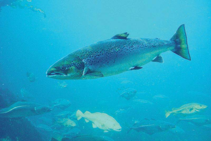
At Beubassin East, you have the Aboujagane River. Yes, it gets bulky near that town, and it's a salmon river. Here is a map of salmon rivers in New Brunswick, including the Aboujagane:Rivers change over the centuries, so could well be that it was more of a lake previously.
Also, note, a large lake might be seen as more of a sea by the vikings. A lake quite likely could have just been a smaller body of water which wasn't directly flowing like a river. For instance at the town of Beaubassin East you have what well could have been seen as a lake, especially of the mouth used to be narrower.
And look at Wallace Bay National Wildlife Area. That's a lake next to a river. Could easily have been that that lake used to be outright connected to the river. And just east of the mouth of that river there's a small island and a næs at Malagash point.
And at the city of Elsipogtog First Nation there's what definitely could be called a lake in a river.
Whether any of those areas fits with salmon, I don't know, but they're examples of where you have a lake.
Right. The Wallace Bay National Wildlife Park has the Akerly Brook and there is a small lake on the Park's south side separated by what looks like a short narrow dyke. Probably the brook has salmon, and I saw someone saying that he was going to go salmon fishing at the Park.
Here is a zoomed out map of Nova Scotia's salmon rivers:
Mapping the threat status of wild Atlantic salmon
Groups protecting Atlantic salmon spawning grounds on Canada’s East Coast have a new view of the problems facing the prized species
 canadiangeographic.ca
The Elsipogtog First Nation has the Richibucto River near it, and it must have salmon.
What you are saying makes sense.I know what a peninsula is. And I'm telling you what a næs is AND that the official, Danish translations use næs. Translations made by professors at the Arnamagneæske Institute in Copenhagen who'd be experts in the sagas. So honestly, given cape seems to not be able to cover a peninsula, then I'll say that it seems that cape is a poor translation and not teh correct term for it.
In having this discussion, "naes" has for a while reminded me of the English term "Ness," one of those arcane or rare English words that comes up in English and is a shared word or version of a word in Germanic languages. In Modern English it typically shows up in placenames like (A) Orford Ness in eastern England, and (B) Loch Ness, the River Ness, and Inverness in northeast Scotland.
"Orford Ness is a cuspate foreland shingle spit on the Suffolk coast in Great Britain, linked to the mainland at Aldeburgh and stretching along the coast to Orford and down to North Weir Point, opposite Shingle Street." (SOURCE: WIKIPEDIA)
Ness: a promontory; headland (Collins Dictionary)
"noun A cape or headland." (American Heritage Dictionary)
"noun A point of land running into the sea; a promontory; a headland; a cape." (The Century Dictionary)
"CAPE, PROMONTORY"
Examples:
from atop the ness, there was a beautiful view of the coastline as it stretched for miles into the distance
the little skiff rounded the tip of the ness
Etymology
Noun
Middle English nasse, from Old English næss; akin to Old English nasu nose — more at NOSE
(Merriam Webster)
Miscou Island is at the west end of Chaleur Bay, and Chaleur Bay is one of the top considerations by scholars as to where the route from Markland to Leif's camp went. Dr. B. Wallace considered the shallows to the west of Miscou Island to conceptually resemble the shallows' positioning in the Greenlanders' Saga to the west of the Saga's northward "naes." At the west end of the bay there is the Restigouche River, which forks at Matapedia, creating a fat bulk there. It's about 30 miles from Matapedia upriver along the north tributary of the Restigouche River to get to Lac au Saumon. Formally, this lake looks like a top possibility, meeting the recorded requirements for Leifsbudir. Since it's called Lac au Saumon, it must have had salmon in the Vikings' time.In any case, you're looking for an island with a næs close to it that goes northwards.
Miscou Island could be an option for that, as there would be the straights too. Then the river would be around Carleton-sur-mer. And the river starting thre actually has a lake up at Lac-au-Saumon from what I can tell. Whether there's strong tides at Carleton-sur-mer I don't know, but looking at Google Maps it seems there might be a kind of floodplain, so perhaps.
My main concern with this spot would be the feasibility and likelihood of the Vikings going up this river for the 30 miles to Lac au Saumon. I think some logistical constraints should be considered for the idea of the Vikings traveling up rivers to get to lakes in general. For instance, the Saga says that they "conveyed" their ships upriver to a lake, so for me this suggests that literally they sailed, rowed, or hand-carried ("portage") their ships to get to the lake. This works OK if your crew is carrying longships over rocky shoals and shallow rivers. But taking them up rapids or up cliffs doesn't seem as likely to me.
For instance, the St. Lawrence River isn't considered navigable in an upriver direction west from around Montreal westward to Lake Ontario due to the chain of rapids. People portaged their ships upriver along the St. Lawrence River before the canals were built. Jacques Cartier got up to Montreal by sailing up the St. Lawrence River in the 16th century, but stopped at the rapids by Montreal. The Canadians built the St. Lambert Lock in 1959 to allow ships to sail around the Lachine Rapids by Montreal.
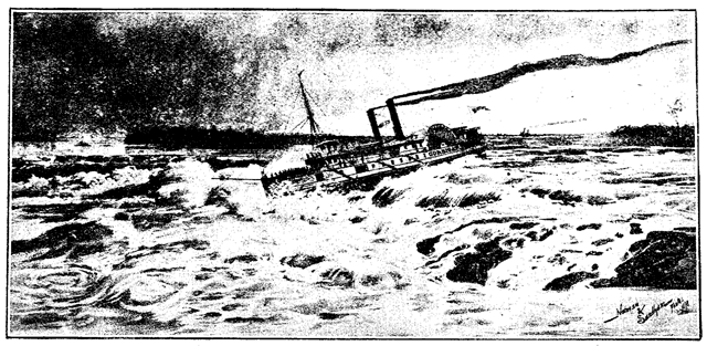
Steamship at the Lachine Rapids in 1890.
So purported Viking artifacts have been found around Lake Ontario to the west of Montreal, but the difficulty in getting upriver is one factor that lessens the likelihood of the Vikings having reached there, without making it impossible.
Hudson Bay doesn't work for the Sagas for a bunch of reasons. But for the sake of amusement, it looks like a way to make the likely Viking hoaxes in the western Great Lakes region (like Minnesota) more feasible, because some people have hypothesized that the Vikings went to the south end of the Hudson Bay and then went over land to Minnesota.If not for Prince Edward's Island, then I'd say that various parts south of Prince Edward's Island could be fine possibilities. E.g. at Malagash point.
In fact, Prince Edward's Island in principle could be the island, but it might be too big, albeit if they explored some more they might have not realised it was an island at first, but have known it later. If so then Cape George is at the tip of a næs, so the straight they go into could be between that and Prince Edward's Island and then the river would be one of the ones to the south of Prince Edward's Island.
There also is the possibility that the island actually is Anticosti island and that the næs is that peninsula going out south of it, and then going west would mean going into Quebec.
There also is the time issue, where south of Prince Edward's Island might be a tad too southern to really fit teh Midwinter times.
Also, it hit me that in principle they could have ended up in Hudson bay. And then the grapes and butternuts were found on different expeditions.
Thanks for the fun talk.
@Wagonlitz
You asked in Message #87 above: "What was it Leifbudir is? The first camp Leif made before going to Dew Island?"
Leifsbudir must be the first camp that Leif made in the Greenlanders' Saga after going to the Dewy Island.
The two Sagas don't narrate Leif making a budir on Markland. Eric the Red's Saga refers to a camp made by Leif, but doesn't narrate the building of the camp. The story of the building of the camp by Leif is in the Greenlanders' Saga, where Leif goes to Markland, then goes southwest and sees to the northward naes, then comes to the dewy island, then gets his boat on shallows, then takes his boat up the salmon river to a salmon lake and makes his budir camp there.
Some scholars like those in the Wikipedia article have made a guess that L'Anse aux Meadows is one of the settlements in the Sagas, such as Leifsbudir, but this guess is unlikely because the coordinates and geography for the settlements in the Sagas conflict with L'Anse aux Meadows. For example, L'anse is not by a salmon lake or salmon river like Leifsbudir is in the Greenlanders' Saga. But sometimes in modern writings making propositions about L'anse aux Meadows, you still can find writers who make the assertion or claim that L'Anse aux Meadows is one of the settlements named in the Sagas.
If in reality L'Anse aux Meadows is mentioned in the Sagas, then the most likely spot in the Sagas is the story about Kjalarnes, because the Vikings crashed a ship at Kjalarnes and used Kjalarnes to rebuild their ship. Plus, in real archaeology, it appears that L'anse aux Meadows was used as a ship repair station.
Last edited:
The King Olaf coin found in the Amerindian Midden at Brooklin, Maine on the Atlantic coast was from about 1060 AD, IIRC, ie. about 30-40 years after the settlement at L'Anse aux Meadows was abandoned.Yes, we already had indications that Greenlanders continued to visit North America for timber. But either we didn't have archeological evidence before or the site this was from is one of those sensationalist Facebook exploiters that draw you in with exciting "news" that's decades old. In any case, the import of the date is not that it's earlier than expected but that it's later than the contact that was already confirmed archeologically.
Greenland was abandoned only in the 15th century. I don't know if there's evidence for trade but there is evidence that Greenlanders went there to cut trees.
I wasn't able to find a more specific date for the carbon dating of the Jack Pine found in Greenland; Jack Pine grows as far northeast as New Brunswick and the mouth of the St Lawrence. I just saw a general date that the general collection of Greenland wood with the Jack Pine dated from like 1000 AD and later in the medieval period.
If the evidence of activity is gone then it might be written off due to there being no surviving evidence.guess that if the site at the Little Cordroy River stood out as a likely actual Viking site, then the investigators would have considered it noteworthy.
And your story sounds more like a longboat than early modern boats, as early modern boats didn't differ that much to 19th century boats AFAIK, but perhaps I'm wrong on that?
Whereas longboats differ vastly, AFAIK.
There were cold before the medieval warming too.Right. In the scenario that grapes actually were there in 1000 AD, the failure of grapes to grow there by now could be due to randomness in nature, or due to the slowness in the spread of certain kinds of flora. So for instance, the medieval warm period helped the grapes last for a while in 1000 AD to 1600 AD when the explorers saw the grapes, but then the earth got cold again and the grapes haven't grown quickly enough in that direction wildly. Further, we know that artificial cultivation of grapes in Newfoundland is happening
How did the grapes get there in the first place if they didn't get back after the little ice age.
Having a crow up there is different from having a mast top for lookout.So I'm not sure if they had people in the mast top, but the Vikings were very skilled seafarers.
AFAIK they didn't. Doesn't mean they can't have sent a man to the top at times of course, but AFAIK they didn't have a man there usually.
I don't think translating mark to Outback would ever be correct, but not certain. Compounds with Mark at the end could mean Outback, but not sure it ever could on its own.Helluland that they noted was an island (Baffin Island), Markland ("Outback land," the Labrador Peninsula).
In any case then it's forest land in this case, AFAIK.
Helluland is stone land, iirc.
But yeah, while Mark can't mean forest anymore, it could in Old Norse.
Mark also can, especially in the past including Old Norse times, mean border land, which actually is where the Mark in Denmark most likely comes from.
Can also mean a field. Or a place or battle. Or even the area with fields around a village.
For Markland then fields or field area doesn't work, as no villages. Battlefield provably not.
If it's a borderland then what's it the borderland of?
So bah, forest works best, and it AFAIK is the official assumed meaning anyway.
Could that island be New Foundland?They said that they sailed south along Markland and then found an island with bears on Markland's southeast in Eric the Red's Saga. So the Vikings' layout in the Sagas was distinguishing the landmass of Markland from islands off its coast.
Like, an island needn't be small.
And if that island is New Foundland then it could be mentioned separately while still be considered part of Markland.
Would mean Bear Islands Islands, assuming there isn't anything tricky in Old Norse I'm missing. Eyar should be Islands. And bjarne would be bear or bears. Not sure if its in plural or not.Bjarneyar islands,
Or it could be something else that just resembles and I'm tricked.
But that'd be my read of it, but I'm in no way an Old Norse expert and don't really know Old Norse as such, but rather know some things in Old Norse as well as being able to compare with Scandi words I know are of Norse origin.
I'm not home atm, so can't check my version, but I don't read it as saying they couldn't see Markland, but rather that they saw New land.take it that they departed from the Labrador Peninsula and sailed for two days in the open sea without seeing land and then finally seeing the northward cape, because it says per Jansson's translation:
Looking some more then it turns out Cape Breton actually is on an island and there's a straight, an actual one, between it and the mainland. The mainland does protrude a bit, but not sure if it'd qualify as a næs, though. But it does have a proper sound and you could reach it by going South East from New Foundland.
are there any traces of them on the Eastern coast?they sailed up both coasts of Greenland,
If they'd reached the Caribbean with its warmth I'd expect them to have recorded it.like to Halifax or to the Caribbean.
Albeit, didn't they think Vinalnd connected to Afrika due to getting hot in the south? Could indicate they may have reached it.
The west of the dewy island could be way west, and could also require going a bit north as long as you jeep going west.The reason why this seems relevant is that if you pick a lake-like spot for where Leif's camp might be, you should consider what kind of mass of many islands and shallows would be to the west of that spot. To me, the closest match for that description would be thinking that Leif's camp was on the west side of Cape Breton, with Prince Edward Island and smaller islands and shallows being along the coast to the west of Cape Breton.
Still, the islands and shallows layout that I mentioned here isn't the only factor.
Also remember that the exploration literally lasted from spring to autumn. That's a long trip.
Could also be at the river mouth that the Isles and shallows are. Though, then Leifs camp wouldn't be up that river, as that was Torfinn seeing that.Wallace considered the shallows to the west of Miscou Island to conceptually resemble the shallows' positioning in the Greenlanders' Saga to the west of the Saga's northward "naes."
Yet we know for certain they sailed up rapids on the Don and other Eastern European rivers that even today requires very experienced rafters going down, let alone up.But taking them up rapids or up cliffs doesn't seem as likely to me.
See above.So purported Viking artifacts have been found around Lake Ontario to the west of Montreal, but the difficulty in getting upriver is one factor that lessens the likelihood of the Vikings having reached there, without making it impossible.
I don't see those rapids as any kind of barrier for the Vikings.
What's that hoax?Hudson Bay doesn't work for the Sagas for a bunch of reasons. But for the sake of amusement, it looks like a way to make the likely Viking hoaxes in the western Great Lakes region (like Minnesota) more feasible, because some people have hypothesized that the Vikings went to the south end of the Hudson Bay and then went over land to Minnesota.
That pine can't grow north of New Brunswick and also couldn't during the Medieval Warming? If so then I'd expect remains of it on Greenland to come from Vikings and then they'd be to NB.Jack Pine grows as far northeast as New Brunswick and the mouth of the St Lawrence. I just saw a general date that the general collection of Greenland wood with the Jack Pine dated from like 1000 AD and later in the medieval period.
- 1
Almost forgot.
Leifbudar or Leifsboder indicates a more permanent settlement, albeit with smaller houses/less elaborate ones.
Though, bod could have had more temporary meanings in Old Norse.
Well, it could also refer to marker stalls, but doubt Leifs camp was a market camp.
Leifbudar or Leifsboder indicates a more permanent settlement, albeit with smaller houses/less elaborate ones.
Though, bod could have had more temporary meanings in Old Norse.
Well, it could also refer to marker stalls, but doubt Leifs camp was a market camp.
- 1
Dear @Wagonlitz
Maybe you can help me with the easiest identifiable land locations south of Labrador in the Sagas, particularly the Island of Bjarney.
Scholars have a general consensus about the following locations narrated as Leif reaching in the following order in the Sagas:
Magnusson's Danish translation of Eric the Red's Saga narrates the finding of Bjarney this way:
Jonsson's 1947 translation describes the discovery of Bjarney in Chapter 8. "Karlsemne finder nyt land":
Eric the Red's Saga actually comes in two separate, very similar versions, the Skálholtsbók and the Hauksbók, with the Skálholtsbók one considered closer to the original. Svenn Jansson translates this Saga's journey from Helluland/Baffin Island to Kjalarnes in English as below. ("Northerly" winds are those that come from the north and blow toward the south):
Here is an overview map of the Labrador Peninsula showing north-south Longitudinal lines:

Here is a map of the south coast of the Labrador Peninsula, labeling islands such as Anticosti Island, Newfoundland, and Belle Island. Quite small coastal islands on the south edge of the Labrador Peninsula are shown, but not labeled:

(click to enlarge the map)
More reasons seem to point to Bjarney being Belle Isle than in favor of it being other known islands.
The identification of Bjarney as one of several known islands (Belle Isle, Newfoundland, and Anticosti Island) has potential ramifications as to how one identifies other locations in the Sagas. This is because Bjarney essentially anchors the eastern extremity of the departure points to sail from Markland to other locations in the Saga. In particular, the Vikings sailed south from Markland to get to Kjalarnes and southwest from Markland to get to the northward cape east of Leifsbudir.
So if one considers Bjarney to be Belle Isle, then Kjalarnes and Leifsbudir would be across the sea somewhere to its south and southwest, respectively. If one considers Bjarney to be Newfoundland, then Kjalarnes and Leifsbudir would be somewhere west of Newfoundland and probably south of it, such as Cape Breton. If one considers Bjarney to be Anticosti Island, then Kjalarnes would be on the Gaspe' Peninsula, and hence Leifsbudir would be reached by sailing up a river on the south shore of the St. Lawrence River.
Next, let's consider the potentlal location of Kjalarnes. There are practically only two regions where Kjalarnes could realistically be, at the north end of Newfoundland, or on the coast that runs from the north end of Cape Breton Island to the northeast end of Cape Breton Island. This is because the Vikings reached it by sailing south from the Labrador Peninsula and because in one passage, a westward wind swept a Viking ship east from Kjalarnes across the Ocean to Ireland.
In Eric the Red's Saga, Kjalarnes shows up in the quote from Chapter 8 that I quoted above about the Bear Island. In that passage, it's not actually clear to me whether (A) the Vikings come to the new land south of Markland first and then sail eastward along the new land's coast to Kjalarnes with the land on their starboard side, or if (B) Kjalarnes is at their arrival location when they sail south from Markland. Here is the section from the Skálholtsbók with Jansson's translation:
In any case, after reaching Kjalarnes, the Vikings sailed east along the coast and south down to Straumsfjord. Then in Chapter 9, Thorhall decides to sail back north to Kjalarnes and then to sail west from Kjalarnes to "Vinland", likely meaning the spot west of Kjalarnes where Leif found grapes in the Greenlanders' Saga. But instead a wind blows Thorhall east to Ireland.
Sephton's 1880 translation has
Further, the excerpt shows that Kjalarnes must have had a side that faced the Atlantic Ocean, as sailing northwards from Kjalarnes exposed Thorhall to a wind that blew him across the Atlantic. If Kjalarnes had been on the inside of the Gulf of St. Lawrence, like on Prince Edward Island, he could have steered his ship toward a coast line that would block him from getting swept eastward into the ocean, as his goal was to sail westward instead.
Kjalarnes also shows up in Chapter 6 of the Greenlanders' Saga. There, Thorvald is staying at Leif's camp and sails eastward and along "the northern coast" and breaks his keel on "a certain promontory." They name the promontory Kjalarnes as a result.
Here is S. Jansson's 1944 translation into English:
One challenge that I have with the passage above is whether the northward headland by the dewy island in the Greenlanders' Saga is the same as the "certain headland" that they named Kjalarnes in the same Saga. When I first read this passage I thought that they might be the same headland (naes). But on a more careful reading, it seems that these are two different headlands because in the Greenlanders' Saga, the Vikings sail southwest to get to the northward headland by the dewy island, whereas in Eric the Red's Saga, they sail southward to get to Kjalarnes.
Another issue is whether the Kjalarnes in the Greenlanders' Saga is the same as the Kjalarnes in Eric the Red's Saga. It seems that they are the same place because they have the same name, and because the two Sagas at times seem to talk about the same places or people but with somewhat different narratives. Further, in the Greenlanders' Saga, they break a keel and put up the keel on Kjalarnes, whereas in Eric the Red's Saga, the Vikings find a keel and call the place Kjalarnes. It's logical that the source of the keel in Eric the Red's Saga was the Vikings' ship in the Greenlanders' Saga, in part because Viking keels were more prominent than Amerindian canoes' keels.
In relating Kjalarnes to a real world location, some considerations are:
1. The departure point to get from Markland (Labrador) to Greenland. One possible departure point is the east end of Labrador near Belle Isle, such as near Cape Charles. One reason is that the Vikings were sailing southward along Labrador's coast. If they kept their southward trajectory they would sail southward into the ocean instead of turning southwest to follow the Labrador coast. In that case, their trajectory would take them near Belle Isle and the top end of Newfoundland. A second reason is that if one designates Bjarney as Belle Island, then Belle Island could serve as a navigational point for the Vikings to use to sail by into the sea to find another land, like when they likely used the Bjarneyar Islands to guide them west to Baffin Island. Third, the east end of Labrador near Belle Isle is the part that juts most toward the center of the North Atlantic, and thus the Vikings might consider it a key point to use for journeys. Fourth, if a reader of the Sagas didn't know that the Labrador Peninsula in real life had a long latitudinal east-west coastline, the reader might easily imagine that Labrador's south side formed a southward point like Greenland's and Baffin Island's south sides do. In that case, the reader would naturally expect the Vikings to make their departure from Markland/Labrador from that southern point. In addition, from the perspective of the center of the North Atlantic, Labrador's east end resemble a similar oceanward point as that of Baffin Island's and Greenland's south ends.
A second potential departure point would be an area like Pointe de la Baie des Loups south of Wolf Bay that is in the area where the Labrador Peninsula's coast ceases to run in a southwestward direction and becomes an east-west coastline. One reason for a departure point like Wolf Bay is that the Vikings could have aimed to sail in an overall southward direction, so that they hugged the coast in a southwest direction and left it behind once the coast changed from a southwestward to a simple westward direction.
However, conceivably the Vikings could have departed Labrador's southern coast from any point between Cape Charles in the east and the inside of the St. Lawrence River east of Quebec City in the west.
2. The distance from Markland/Labrador to Kjalarnes. Eric the Red's Saga says that they sailed two half-days from Markland and sighted land. Based on the days of sailing and distances between Greenland, Baffin Island, and Labrador in the two Sagas, the sailing distance could be anywhere from ~66 miles to ~250 miles in two half days. This is because it takes two half days in Eric the Red's Saga to get from Greenland to Baffin Island (250 miles), and another two half days to get from Baffin Island to Labrador (100 miles). In the Greenlanders' Saga, the sailing times are marked in days rather than "half-days" being specified. As a reader, I took it that these are practically referring to the same overall time periods in both Sagas, since in the Greenlanders' Saga, the Vikings actually cover less ascertainable distance per day, as when it takes the Vikings three "days" to travel the ~100 miles from Baffin Island to Markland. In any case, based on the other sailing times in Eric the Red's Saga, one would expect that Vikings sailed 100 to 250 miles before sighting land.
Further, scholars say that Viking ships normally traveled at an average of ~7 mph, but at an optimal speed would reach ~11 mph. This would put them at a distance of 168 miles at an average speed in two half-days, or 264 miles at an optimal speed in two half-days.
On top of the distance that the Vikings sailed to see land, one would add the distance that the Vikings could see from their boats in order to find the distance between the two lands. From the top of a Viking mast, one could see ~10 miles, but lower on the ship from its 6' gunwales one might just see for ~5 miles, IIRC. On the other hand, one can imagine that a sailor could see a mountain from farther away.
3. The Vikings' area of arrival that would count as Kjalarnes.
One option is the northern end of Newfoundland. In favor of this location is that it's directly south of the east end of Labrador near Belle Isle. A second reason favoring this location is that L'Anse aux Meadows is on the north end of Newfoundland. Archaeologists say that the Vikings used L'Anse aux Meadows for ship repairs and didn't settle there. This description resembles how the Greenlanders' Saga describes the Vikings using Kjalarnes for ship repairs. The Saga says that they "had a long stay there" while they repaired their ship, and this description accords with making a small settlement at the location during the repairs. As a result, if L'anse aux Meadows were to match any location in the Sagas, Kjalarnes seems the closest match. A third reason is that in Eric the Red's Saga, an eastward wind blows the Vikings to Ireland, and L'anse aux Meadows is at 51°35′47″N Latittude, and it's a wide open route east from northern Newfoundland to Ireland. By comparison, Killarney (from the Gaelic name Cill Airne, Church of Sloes) in southwestern Ireland is at 52.1° Latittude, and Mizen Head, Ireland is at 51°27′ Latitude, ie. south of L'anse aux Meadows. I wasn't able to find how the Irish city of Killarney got its name (Cill Airne), and wonder if it could be related to Kjalarnes somehow.
However, I don't have any easy way to make the two half days' sailing distance from Labrador fit well with the north end of Newfoundland. The distance from Labrador to the northwest coast of Newfoundland that faces Labrador is only 10.8-20 miles. It's under 43 miles from Cape Charles, Labrador to L'anse aux Meadows. The Hauksbok version doesn't give a time, like two half days, for the journey from Markland to Kjalarnes.
A second option is the coastline running from Cape St. Lawrence at the north end of Cape Breton to Wreck Point at the northeast end of Cape Breton. This second option is the area that one would arrive at if one sailed directly south from Pointe de la Baie des Loups south of Wolf Bay on the Labrador Peninsula. The distance from Pointe de la Baie des Loups to Cape St. Lawrence is 219 miles, which is well within the distance that one would expect to sail in a Viking ship in two half-days.
Cape St. Lawrence at the north end of Cape Breton Island is at 47 Degrees Latitude. By comparison, the island of Noirmoutier on France's West Coast is at 47 Degrees Latitude. However, since the North Atlantic currents flow in a spiral clockwise direction, one might expect that the currents might carry a ship like Thorhall's boat sailing east from the north end of Nova Scotia to Ireland, as per the Atlantic current chart below:

Sailing eastward from Nova Scotia in a storm, one might naturally come across Newfoundland's long southern coast and be able to land there to escape the storm. However, Newfoundland's southern coast doesn't totally block one's straight path into the Atlantic Ocean.
A potential problem for this second option of Cape Breton as the arrival site is that it would mean that Eric the Red's Saga would be leaving out mention of Newfoundland. In other words, if the Saga's narration was that the Vikings found Belle Isle and then sailed south to Cape Breton Island as the first land that they sighted, one would wonder why they the story doesn't mention Newfoundland like it mentions Belle Isle. One would wonder why they didn't see Newfoundland in the course of their southward sail. If one sails along the Labrador coast from Cape Charles to Wolf Bay, Newfoundland would naturally lay even closer to one's coastal route than Belle Isle does. Newfoundland is only 10.8 miles from Labrador at the closest point, whereas Belle Isle is a bit over 17 miles from Labrador.
I traced the two southward route options, from Cape Charles and the Wolf Bay area of Labrador to Newfoundland and Cape Breton, respecitvely, on this map:

Maybe you can help me with the easiest identifiable land locations south of Labrador in the Sagas, particularly the Island of Bjarney.
Scholars have a general consensus about the following locations narrated as Leif reaching in the following order in the Sagas:
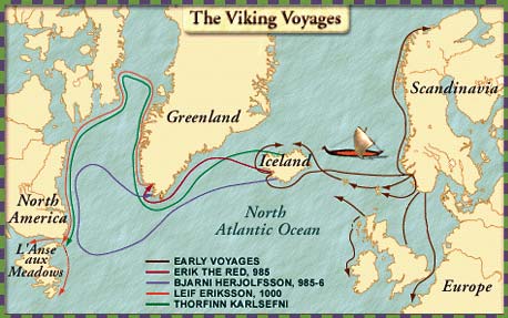
- Brattahlid is at the Vikings' southern settlement at the south end of Greenland. This is where the Vikings set out from in order to ultimately reach Vinland after visiting a series of other places.
- Vestribygd is the Western Settlement, located in the fjords and seashore valleys east of what is today Nuuk in Greenland.
- The Bjarneyar islands, meaning Bear Islands, must be a collection of islands north of Nuuk and off the west coast of Greenland. They would as a matter of logistics be sensibly located to the east of the eastern end of Baffin Island, so that the Vikings crossed the sea to Baffin Island from an area near Bjarneyar. Scholars commonly include Disko Island as one of the Bjarneyar, and there are a chain of coastal islands north and south of Disko Island. Polar bears live on these islands.
- Helluland, meaning Flat Stone Land, is naturally Baffin Island, because the Vikings sailed 2-4 days west from Greenland to get there, just like it would have taken them to get to Baffin Island.
- Markland means Outback Land, and logically was the Labrador Peninsula, as it took the Vikings two days of sailing to get south from Helluland to Markland, like how one would sail south from Baffin Island to get to Labrador, which is a wooded land like the Sagas say about Labrador.
Magnusson's Danish translation of Eric the Red's Saga narrates the finding of Bjarney this way:
Þaðan[612] sigldu þeir [II dægr í suðr[613]; [þá sá[614] þeir land, ok [skutu báti[615], ok könnuðu[616] landit, ok fundu þar hellur [stórar, ok margar XII álna viðar[617]; fjöldi var þar melrakka. Þeir gáfu [þar nafn, ok kölluðu[618] Helluland. Þaðan[619] sigldu þeir[620] II dægr, [ok[621] brá til landsuðrs or suðri[622], ok fundu land skógvaxit[623], ok mörg dyr á; ey lá þar undan[624] i landsuðr; [þar í drápu þeir einn björn[625], ok kölluðu þar síðan Bjarney[626], en landit Markland[627]. [Þaðan sigldu þeir suðr með landinu lánga stund, ok komu at nesi einu; lá landit á stjórn; voru þar[628] strandir lángar ok sandar þeir rèru[629] til lands, ok [fundu þar á nesínu[630] kjöl af skipi, ok kölluðu þar[631] Kjalarnes; þeir [kölluðu ok strandirnar[632] Furðustrandir, þvíat lángt [var með[633]> at sigla. Þá gerðist landit vágskorið; þeir héldu skipunum [í einn vág[634].
FOOTNOTES
625. ok fundu þeir þar bjarndyr, og der fandt de en Björn, B, M.
626. saaledes D, H, B; Bjanney, efter Udtalen, A.
FOOTNOTES
625. ok fundu þeir þar bjarndyr, og der fandt de en Björn, B, M.
626. saaledes D, H, B; Bjanney, efter Udtalen, A.
Jonsson's 1947 translation describes the discovery of Bjarney in Chapter 8. "Karlsemne finder nyt land":
Derfra sejlede de to halvdøgn og svingede fra syd mod sydøst og stødte på et skovbevokset land med mange dyr. Sydøst derfor lå en ø. Dér dræbte de en bjørn, og de kaldte siden stedet Bjørneø og landet Skovland. Derfra sejlede de længe sydpå langs med landet og kom til et næs. Landet lå på styrbords side, og der var lange strand og sandgrunde. De roede i land og fandt dér på næsset kølen af et skib og kaldte stedet Kølsnæs. De kaldte strandene Furdestrandene, fordi der var så langt at sejle langs dem. Derpå blev landet gennemskåret af vige. De styrede skibene ind i en vig.
Skálholtsbók version
Then they sailed on a northerly wind for two days and then there was a land before them on which there was a great forest and many animals.
An island lay off the land to the southeast and there they found a bear and called [the place] Bjarney (‘Bear Island’). But the land they called Markland (‘Forest Land’) where the forest is.
When two days had passed they sighted land and they sailed along the coast. There was a promontory. When they got there they tacked along the coast, keeping the land to starboard.
There were wastes there and long, sandy beaches.
They go on boats to land and got shelter from a ship and called the place Kjalarnes (‘Keel Point’).
They also gave the coasts a name and called them Furustrandir (‘Wonder Beaches’) because it was a long way to sail down them.
Hauksbók version
From there they sailed for two days and the wind shifted from south to southeast and they found a wooded land with many animals on it.
An island lay offshore to the southeast. There they killed a bear and from this called the place Bjarney and the land Markland.
From there they sailed south along the coast for a long time and came to a promontory. The land lay to starboard.
There were long, sandy beaches there.
They rowed to land and found there on the headland a ship’s keel and called the place Kjalarnes.
They also called the coasts Furðustrandir because it was a long way to sail down them.
Here is an overview map of the Labrador Peninsula showing north-south Longitudinal lines:
Here is a map of the south coast of the Labrador Peninsula, labeling islands such as Anticosti Island, Newfoundland, and Belle Island. Quite small coastal islands on the south edge of the Labrador Peninsula are shown, but not labeled:
(click to enlarge the map)
More reasons seem to point to Bjarney being Belle Isle than in favor of it being other known islands.
- Belle Isle is totally to the southeast of Labrador's easternmost coastline near Cape Charles. If one took the Vikings' route and sailed south down Labrador's east coast with the southward winds that brought the Vikings from Baffin Island to Labrador, one would get to Belle Isle before the other islands like Newfoundland, and Belle Isle would be off to one's southeast side. Further, suppose that one pays special attention to the points of several lands in relation to the center of the North Atlantic, such as Ireland's west end, Greenland's south end, the southeast end of Baffin Island, and the east end of the Labrador Peninsula as this map of the Vikings' journeys shows below. In that case, Belle Island and Newfoundland would be the two islands offshore to the southeast from this point on the Labrador Peninsula.
- Belle Island occasionally gets polar bears, and Mrs. Ingstad used this to suggest that Bjarney was Belle Isle. In contrast, Newfoundland not only had bears, but also Beothuk Indians, and it seems that Beothuk Indians would be more identifiable for an island on which they lived than bears.
- If Bjarney resembles the Bjarneyar islands off the coast of Greenland, then it's notable that Belle Island is 20 square miles in size. There are quite a few islands that are about Belle Isle's size between Nuuk and Disko Island. In contrast, Newfoundland's size is 42,031 square miles and resembles the size of Iceland.
- As Belle Isle is on the southeast edge of the east end of Labrador, Belle Isle can serve as a navigational guide like how the Bjarneyar islands on Greenland's west coast may have signaled to the Vikings to stop sailing northward along Greenland and to turn westward to Baffin Island.
- As a navigational guide, Belle Isle works well as a practical guidepost to get to the Viking site at L'Anse aux Meadows. If one sailed south from Labrador's coast near Belle Island, like from Labrador's Pleasure Harbor, one would land on Newfoundland about 5 miles to the west of L'Anse aux Meadows.
- Whereas there is a chain of islands on Greenland's west coast that could be called the "Bjarneyar" islands as group, Belle Isle sits by itself north of Newfoundland and east of Labrador, and thus could be readily designated as a single "Bjarney", Bear island.
The identification of Bjarney as one of several known islands (Belle Isle, Newfoundland, and Anticosti Island) has potential ramifications as to how one identifies other locations in the Sagas. This is because Bjarney essentially anchors the eastern extremity of the departure points to sail from Markland to other locations in the Saga. In particular, the Vikings sailed south from Markland to get to Kjalarnes and southwest from Markland to get to the northward cape east of Leifsbudir.
So if one considers Bjarney to be Belle Isle, then Kjalarnes and Leifsbudir would be across the sea somewhere to its south and southwest, respectively. If one considers Bjarney to be Newfoundland, then Kjalarnes and Leifsbudir would be somewhere west of Newfoundland and probably south of it, such as Cape Breton. If one considers Bjarney to be Anticosti Island, then Kjalarnes would be on the Gaspe' Peninsula, and hence Leifsbudir would be reached by sailing up a river on the south shore of the St. Lawrence River.
Next, let's consider the potentlal location of Kjalarnes. There are practically only two regions where Kjalarnes could realistically be, at the north end of Newfoundland, or on the coast that runs from the north end of Cape Breton Island to the northeast end of Cape Breton Island. This is because the Vikings reached it by sailing south from the Labrador Peninsula and because in one passage, a westward wind swept a Viking ship east from Kjalarnes across the Ocean to Ireland.
In Eric the Red's Saga, Kjalarnes shows up in the quote from Chapter 8 that I quoted above about the Bear Island. In that passage, it's not actually clear to me whether (A) the Vikings come to the new land south of Markland first and then sail eastward along the new land's coast to Kjalarnes with the land on their starboard side, or if (B) Kjalarnes is at their arrival location when they sail south from Markland. Here is the section from the Skálholtsbók with Jansson's translation:
But it sounds like the "land" where they arrive is the same "land" that they call Kjalarnes when the text says a couple sentences later:þa er lidin uorv tvau dægr sia þeir . lannd . ok þeir sigldu unndir lanndit . þar . var nes er þeir kvomu at þeir. beittu med lanndinu ok letv lanndit aa stiorn borda.
When two days had passed they sighted land and they sailed along the coast. There was a promontory. When they got there they tacked along the coast, keeping the land to starboard.
fara þeir a . batum til lanndz ok fengu skiol af skipi ok kaulludu þar. kialar nes
They go on boats to land and got shelter from a ship and called the place Kjalarnes (‘Keel Point’).
In any case, after reaching Kjalarnes, the Vikings sailed east along the coast and south down to Straumsfjord. Then in Chapter 9, Thorhall decides to sail back north to Kjalarnes and then to sail west from Kjalarnes to "Vinland", likely meaning the spot west of Kjalarnes where Leif found grapes in the Greenlanders' Saga. But instead a wind blows Thorhall east to Ireland.
9. Om Torhall Fangstmand
Det fortælles, at Torhall Fangstmand ville sejle norden om Furdestrande og forbi Kølsnæs for at finde Vinland, mens Karlsemne ville drage sydpå langs landet. Torhall gjorde sig klar ude under øen, men de blev ikke flere end ni mand, for alle de øvrige fulgtes med Karlsemne. Da Torhall bar vand om bord på skibet og drak af det, kvad han et vers:
Skjoldtings skadevolderskænk mig loved’ herlig
(drøjt jeg dadler landet)dengang på færd hértil.
...
Derpå sejlede de nordpå forbi Furdestrandene og Kølsnæs og agtede at krydse vestpå. Så fik de kraftig vestenvind imod sig og blev drevet til Irland. Dér blev de bankede og gjort til trælle, og dér mistede Torhall livet, efter hvad købmænd har fortalt.
One might conclude from this excerpt that Vinland and Kjalarnes are on separate landmasses because Thorhall sailed west from Kjalarnes to seek Vinland, as if Vinland were a separate "land." By comparison, Markland and Helluland were both called "lands" and were in fact separate landmasses. However, one might also think that Vinland Kjalarnes were simply different lands on the same landmass.When summer was at hand they discussed about their journey, and made an arrangement. Thorhall the Sportsman wished to proceed northwards along Furdustrandir, and off Kjalarnes, and so seek Vinland...
Then they left, and sailed northwards along Furdustrandir and Kjalarnes, and attempted there to sail against a wind from the west. A gale came upon them, however, and drove them onwards against Ireland, and there were they severely treated, enthralled, and beaten. Then Thorhall lost his life.
Further, the excerpt shows that Kjalarnes must have had a side that faced the Atlantic Ocean, as sailing northwards from Kjalarnes exposed Thorhall to a wind that blew him across the Atlantic. If Kjalarnes had been on the inside of the Gulf of St. Lawrence, like on Prince Edward Island, he could have steered his ship toward a coast line that would block him from getting swept eastward into the ocean, as his goal was to sail westward instead.
Kjalarnes also shows up in Chapter 6 of the Greenlanders' Saga. There, Thorvald is staying at Leif's camp and sails eastward and along "the northern coast" and breaks his keel on "a certain promontory." They name the promontory Kjalarnes as a result.
Sommeren efter drog Torvald østpå med skibet og norden om landet. Ud for et næs fik de hvast vejr, som slog dem op på land dér, og kølen blev knust under skibet, og de måtte opholde sig længe dér for at udbedre skaden. Da sagde Torvald til sine rejsefæller: »Nu vil jeg, at vi rejser kølen her på næsset og kalder det Kølsnæs.« Og det gjorde de. Derefter sejlede de derfra og østpå langs landet og ind i den nærmeste fjordmunding og hen til en landtunge dér. Den var aldeles skovklædt. Dér lagde de til med skibet og skød landgangen ud, og dér gik Torvald i land med alle sine rejsefæller.
The second summer Þorvaldr went east with the ship and further north around the coast. Then they ran into sharp weather off a certain headland and were blown onto the shore there, and broke the keel from under the ship and they had a long stay there while they repaired their ship. Then Þorvaldr said to his companions: ‘Now I want us to put up the keel here on the headland and we’ll call it Kjalarnes.’ And this they did. Then they sail away from there and east along the coast and into the mouths of the bays that were closest at hand and to a cape that jutted out there. It was all covered with woods. Then they berth their ship in the roads and put out a gangplank and Þorvaldr goes up onto the shore with all his companions.
One challenge that I have with the passage above is whether the northward headland by the dewy island in the Greenlanders' Saga is the same as the "certain headland" that they named Kjalarnes in the same Saga. When I first read this passage I thought that they might be the same headland (naes). But on a more careful reading, it seems that these are two different headlands because in the Greenlanders' Saga, the Vikings sail southwest to get to the northward headland by the dewy island, whereas in Eric the Red's Saga, they sail southward to get to Kjalarnes.
Another issue is whether the Kjalarnes in the Greenlanders' Saga is the same as the Kjalarnes in Eric the Red's Saga. It seems that they are the same place because they have the same name, and because the two Sagas at times seem to talk about the same places or people but with somewhat different narratives. Further, in the Greenlanders' Saga, they break a keel and put up the keel on Kjalarnes, whereas in Eric the Red's Saga, the Vikings find a keel and call the place Kjalarnes. It's logical that the source of the keel in Eric the Red's Saga was the Vikings' ship in the Greenlanders' Saga, in part because Viking keels were more prominent than Amerindian canoes' keels.
In relating Kjalarnes to a real world location, some considerations are:
1. The departure point to get from Markland (Labrador) to Greenland. One possible departure point is the east end of Labrador near Belle Isle, such as near Cape Charles. One reason is that the Vikings were sailing southward along Labrador's coast. If they kept their southward trajectory they would sail southward into the ocean instead of turning southwest to follow the Labrador coast. In that case, their trajectory would take them near Belle Isle and the top end of Newfoundland. A second reason is that if one designates Bjarney as Belle Island, then Belle Island could serve as a navigational point for the Vikings to use to sail by into the sea to find another land, like when they likely used the Bjarneyar Islands to guide them west to Baffin Island. Third, the east end of Labrador near Belle Isle is the part that juts most toward the center of the North Atlantic, and thus the Vikings might consider it a key point to use for journeys. Fourth, if a reader of the Sagas didn't know that the Labrador Peninsula in real life had a long latitudinal east-west coastline, the reader might easily imagine that Labrador's south side formed a southward point like Greenland's and Baffin Island's south sides do. In that case, the reader would naturally expect the Vikings to make their departure from Markland/Labrador from that southern point. In addition, from the perspective of the center of the North Atlantic, Labrador's east end resemble a similar oceanward point as that of Baffin Island's and Greenland's south ends.
A second potential departure point would be an area like Pointe de la Baie des Loups south of Wolf Bay that is in the area where the Labrador Peninsula's coast ceases to run in a southwestward direction and becomes an east-west coastline. One reason for a departure point like Wolf Bay is that the Vikings could have aimed to sail in an overall southward direction, so that they hugged the coast in a southwest direction and left it behind once the coast changed from a southwestward to a simple westward direction.
However, conceivably the Vikings could have departed Labrador's southern coast from any point between Cape Charles in the east and the inside of the St. Lawrence River east of Quebec City in the west.
2. The distance from Markland/Labrador to Kjalarnes. Eric the Red's Saga says that they sailed two half-days from Markland and sighted land. Based on the days of sailing and distances between Greenland, Baffin Island, and Labrador in the two Sagas, the sailing distance could be anywhere from ~66 miles to ~250 miles in two half days. This is because it takes two half days in Eric the Red's Saga to get from Greenland to Baffin Island (250 miles), and another two half days to get from Baffin Island to Labrador (100 miles). In the Greenlanders' Saga, the sailing times are marked in days rather than "half-days" being specified. As a reader, I took it that these are practically referring to the same overall time periods in both Sagas, since in the Greenlanders' Saga, the Vikings actually cover less ascertainable distance per day, as when it takes the Vikings three "days" to travel the ~100 miles from Baffin Island to Markland. In any case, based on the other sailing times in Eric the Red's Saga, one would expect that Vikings sailed 100 to 250 miles before sighting land.
Further, scholars say that Viking ships normally traveled at an average of ~7 mph, but at an optimal speed would reach ~11 mph. This would put them at a distance of 168 miles at an average speed in two half-days, or 264 miles at an optimal speed in two half-days.
On top of the distance that the Vikings sailed to see land, one would add the distance that the Vikings could see from their boats in order to find the distance between the two lands. From the top of a Viking mast, one could see ~10 miles, but lower on the ship from its 6' gunwales one might just see for ~5 miles, IIRC. On the other hand, one can imagine that a sailor could see a mountain from farther away.
3. The Vikings' area of arrival that would count as Kjalarnes.
One option is the northern end of Newfoundland. In favor of this location is that it's directly south of the east end of Labrador near Belle Isle. A second reason favoring this location is that L'Anse aux Meadows is on the north end of Newfoundland. Archaeologists say that the Vikings used L'Anse aux Meadows for ship repairs and didn't settle there. This description resembles how the Greenlanders' Saga describes the Vikings using Kjalarnes for ship repairs. The Saga says that they "had a long stay there" while they repaired their ship, and this description accords with making a small settlement at the location during the repairs. As a result, if L'anse aux Meadows were to match any location in the Sagas, Kjalarnes seems the closest match. A third reason is that in Eric the Red's Saga, an eastward wind blows the Vikings to Ireland, and L'anse aux Meadows is at 51°35′47″N Latittude, and it's a wide open route east from northern Newfoundland to Ireland. By comparison, Killarney (from the Gaelic name Cill Airne, Church of Sloes) in southwestern Ireland is at 52.1° Latittude, and Mizen Head, Ireland is at 51°27′ Latitude, ie. south of L'anse aux Meadows. I wasn't able to find how the Irish city of Killarney got its name (Cill Airne), and wonder if it could be related to Kjalarnes somehow.
However, I don't have any easy way to make the two half days' sailing distance from Labrador fit well with the north end of Newfoundland. The distance from Labrador to the northwest coast of Newfoundland that faces Labrador is only 10.8-20 miles. It's under 43 miles from Cape Charles, Labrador to L'anse aux Meadows. The Hauksbok version doesn't give a time, like two half days, for the journey from Markland to Kjalarnes.
A second option is the coastline running from Cape St. Lawrence at the north end of Cape Breton to Wreck Point at the northeast end of Cape Breton. This second option is the area that one would arrive at if one sailed directly south from Pointe de la Baie des Loups south of Wolf Bay on the Labrador Peninsula. The distance from Pointe de la Baie des Loups to Cape St. Lawrence is 219 miles, which is well within the distance that one would expect to sail in a Viking ship in two half-days.
Cape St. Lawrence at the north end of Cape Breton Island is at 47 Degrees Latitude. By comparison, the island of Noirmoutier on France's West Coast is at 47 Degrees Latitude. However, since the North Atlantic currents flow in a spiral clockwise direction, one might expect that the currents might carry a ship like Thorhall's boat sailing east from the north end of Nova Scotia to Ireland, as per the Atlantic current chart below:
Sailing eastward from Nova Scotia in a storm, one might naturally come across Newfoundland's long southern coast and be able to land there to escape the storm. However, Newfoundland's southern coast doesn't totally block one's straight path into the Atlantic Ocean.
A potential problem for this second option of Cape Breton as the arrival site is that it would mean that Eric the Red's Saga would be leaving out mention of Newfoundland. In other words, if the Saga's narration was that the Vikings found Belle Isle and then sailed south to Cape Breton Island as the first land that they sighted, one would wonder why they the story doesn't mention Newfoundland like it mentions Belle Isle. One would wonder why they didn't see Newfoundland in the course of their southward sail. If one sails along the Labrador coast from Cape Charles to Wolf Bay, Newfoundland would naturally lay even closer to one's coastal route than Belle Isle does. Newfoundland is only 10.8 miles from Labrador at the closest point, whereas Belle Isle is a bit over 17 miles from Labrador.
I traced the two southward route options, from Cape Charles and the Wolf Bay area of Labrador to Newfoundland and Cape Breton, respecitvely, on this map:
That would make sense: I imagine that both early modern boats and 19th century boats included rowboats, which looked different from longboats.And your story sounds more like a longboat than early modern boats, as early modern boats didn't differ that much to 19th century boats AFAIK, but perhaps I'm wrong on that?
Most likely birds would have carried the seeds to Newfoundland originally.How did the grapes get there in the first place if they didn't get back after the little ice age.
I guess they could have died out in the 18th-19th centuries during the Little Ice Age and not enough time and natural coincidences have occurred for the grapes to grow back naturally on their own in Newfoundland. L. A. Anspach's 1819 book on Newfoundland gives information on whether grapes could be found in 18th-19th century Newfoundland:Dispersal
Wild grape seeds require full sunlight to germinate. The birds and small mammals that feed on the fruit spread the seeds. Once buried in the soil, a grape seed can lay dormant for many years, waiting for the required conditions to sprout. Grape can also sprout from the roots or the cut vine stumps.
https://extension.psu.edu/wild-grape#:~:text=Wild grape seeds require full,or the cut vine stumps.
says Doctor Robertson... "I should think that the situation of Newfoundland corresponds best with that of the country discovered by the Norwegians. Grapes however are not the production of that barren island."
In answer to this objection, we must observe... With respect to Newfoundland, Patrick Gordon, in the ninth edition of his Geography Anatomnized, published in London in the year 1722, positively asserts, that those parts of the island which were then possessed by the French, namely from Cape Bonavista round the north to Point Riche, as settled by the treaty of Utrecht, produced plenty of vines; and in a French translation of that work, from the sixteenth edition, published at Paris in the year 1748, the same assertion is found in these words: "Les cantons que les Francois y possedent produicent des vignes en abondance." [Danish translation: "De kantoner, som franskmændene har der, producerer vinstokke i overflod."]
"A History of the Island of Newfoundland: containing a description of the island, the Banks, the fisheries and trade of Newfoundland and the coast of Labrador." by Anspach, Lewis Amadeus.
If it's a borderland, then it could refer to the border of the world, or the outback of Greenland's west side.I don't think translating mark to Outback would ever be correct, but not certain. Compounds with Mark at the end could mean Outback, but not sure it ever could on its own.
...
But yeah, while Mark can't mean forest anymore, it could in Old Norse.
Mark also can, especially in the past including Old Norse times, mean border land, which actually is where the Mark in Denmark most likely comes from.
...
If it's a borderland then what's it the borderland of?
In medieval Europe, a march or mark was, in broad terms, any kind of borderland,[1] as opposed to a national "heartland". More specifically, a march was a border between realms or a neutral buffer zone under joint control of two states in which different laws might apply. ... The Proto-Germanic *marko gave rise to the Old English word mearc and Frankish marka, as well as Old Norse mǫrk meaning "borderland, forest",[2] and derived from merki "boundary, sign",[2] denoting a borderland between two centres of power. ...
The name Denmark preserves the Old Norse cognates merki ("boundary") mǫrk ("wood", "forest") up to the present. ....
In Norse, "mark" meant "borderlands" and "forest"; ...
The forests surrounding Norwegian cities are called "Marka" – the marches. For example, the forests surrounding Oslo are called Nordmarka, Østmarka and Vestmarka – i.e. the northern, eastern and western marches.
In Norway, note also:
- the Norwegian county Finnmark, "the borderlands (or, the forests) of the Sami" (known to the Norse as Finns)
- Hedmark ("the borderlands of heath")
- Telemark ("the borderlands of the Þela tribe"[8]).
Sephton's 1880 translation of Eric the Red's Saga says:This was a level wooded land, and there were broad stretches of white sand where they went, and the land was level by the sea. Then said Leif, ‘This land shall have a name after its nature, and we will call it Markland.’
An island lay in the south-east off the land, and they found bears thereon, and called the island Bjarney (Bear Island); but the mainland, where the forest was, they called Markland (forest-land).
| Skálholtsbók version (An island lay off the land to the southeast and there they found a bear and called [the place] Bjarney (‘Bear Island’). But the land they called Markland (‘Forest Land’) where the forest is.) | Hauksbok version (An island lay offshore to the southeast. There they killed a bear and from this called the place Bjarney and the land Markland.) |
Fun tangent: A Markland is a Scottish land measurement unit:
A markland or merkland (Scottish Gaelic: Marg-fhearainn) is an old Scottish unit of land measurement.
There was some local variation in the equivalences; for example, in some places eight ouncelands were equal to one markland, but in others, such as Islay, a markland was twelve ouncelands. The markland derived its name from the old coin, the Merk Scots (cognate with German mark and various other European coinages, see Mark (money)), which was the annual rent paid on it.
There was some local variation in the equivalences; for example, in some places eight ouncelands were equal to one markland, but in others, such as Islay, a markland was twelve ouncelands. The markland derived its name from the old coin, the Merk Scots (cognate with German mark and various other European coinages, see Mark (money)), which was the annual rent paid on it.
Right. This is one of the tricky topics for me about the Sagas' locations, ie. whether Bjarney is Belle Isle or Newfoundland. If Bjarney is Newfoundland, then it's notable that the Sagas practically skip over it, except for the one mention in Eric the Red's Saga, whereas in real world archaeology, we know that the Vikings made a little settlement on Newfoundland's north end for about 10 years. On the other hand, Bjarney being Newfoundland would make it more easier to identify Cape Breton as Kjalarnes, because that way it would mean that the Vikings didn't skip over Newfoundland on their narrative of reaching Cape Breton.Could that island [Bjarney] be New Foundland?
Like, an island needn't be small.
Here is the Old Norse original in two versions, Skalholtsbok on the left (considered more original) and the Hauksbok on the right, with Jansson's 1944 translation below each:I'm not home atm, so can't check my version, but I don't read it as saying they couldn't see Markland, but rather that they saw New land.
| þa er lidin uorv tvau dægr sia þeir . lannd . ok þeir sigldu unndir lanndit . þar . var nes er þeir kvomu at þeir. beittu med lanndinu ok letv lanndit aa stiorn borda. (When two days had passed they sighted land and they sailed along the coast. There was a promontory. When they got there they tacked along the coast, keeping the land to starboard.) | þaþan sigldv þeir svðr með landinv langa stvnd ok komv at nesi einv la landit a stiorn (From there they sailed south along the coast for a long time and came to a promontory. The land lay to starboard.) |
In the English translation, it says that the sailors "sighted land", not "sighted a land" or "sighted a promontory." In English when sailors are on a voyage and "sight land," the implication for me is that they were on the open sea and lost sight of land and then "slighted land" again, like when Columbus "sighted land" when he arrived at the Americas in 1492. If the Vikings were sailing along a coastline all the way from Markland to Kjalarnes, then it would be pointless to say that they "sighted land" at Kjalarnes, because if they had been hugging the coast, they would have been constantly "seeing land" and "sighting land."
The settlement on Greenland's south pointed end is called the Vikings' "Eastern Settlement."are there any traces of them on the Eastern coast [of Greenland]?
Wikipedia's entry on Tasiilaq on Greenland's east coast says:
The people of Saqqaq culture were the first to reach eastern Greenland, arriving from the north,[2] through what is now known as Peary Land and Independence Fjord, to be surpassed by the Dorset culture. The Norse would have been familiar with the area as the first landmark on the voyage between Iceland's Snæfellsnes peninsula and Greenland.
The Wikipedia article on greenland, including the section on Danish recolonization of Greenland has:
Most of the old Norse records concerning Greenland were removed from Trondheim to Copenhagen in 1664 and subsequently lost, probably in the Copenhagen Fire of 1728.[60] The precise date of rediscovery is uncertain because south-drifting icebergs during the Little Ice Age long made the eastern coast unreachable. ... In the second half of the 17th century Dutch, German, French, Basque, and Dano-Norwegian ships hunted bowhead whales in the pack ice off the east coast of Greenland, regularly coming to shore to trade and replenish drinking water. ... In 1931, Norwegian meteorologist Hallvard Devold occupied uninhabited eastern Greenland, on his own initiative. After the fact, the occupation was supported by the Norwegian government, who claimed the area as Erik the Red's Land. Two years later, the Permanent Court of International Justice ruled in favor of Denmark.
You are getting into an ambiguous area with evidence pointing in opposite directions.If they'd reached the Caribbean with its warmth I'd expect them to have recorded it.
Albeit, didn't they think Vinalnd connected to Afrika due to getting hot in the south? Could indicate they may have reached it.
I don't have a strong expectation as to whether the Vikings would have recorded it and whether the Viking records about them would have survived to us.
One issue is logistics. The Vikings had a couple longships that could sail well and far, but I don't know how far south they were aiming at going. Columbus' crew was getting restless on his journey west, anxious when they hadn't yet sighted land. So in the Vikings' case, they might have been making a trip from Greenland aiming at making a few settlements and getting resources in climates close to Greenland, but not actually planning to get to some extremely far off place like the modern nation of Brazil, where Africa is closest to the Americas.
Another factor is the likelihood of a Viking ship getting back to Greenland to "tell the tale" of its trip to the Caribbean. Suppose that the Vikings got to the Caribbean and then their boat crashed, they got a tropical disease, or else they got into a battle with overpowering numbers of Mayans. It seems likely that they wouldn't return.
A third problem and this isn't just a problem with voyages to the Caribbean: the disappearance of records. Suppose that the Vikings actually had a couple other major stories to tell about Vinland, and then they put it in medieval style books in Greenland. Supposedly when the Norse settlements in Greenland ended, all records kept at those places were lost. In the case of the Western settlement (like east of Nuuk), some medieval Scandinavians went there to investigate the situation, and no one was found there except for herd animals roaming loose. One theory is that the Thule Eskimos massacred the Western Settlement in Greenland. Likewise, I didn't find information that the members of the Eastern Settlement in Vinland's south side packed up and sailed home to Europe in some kind of orderly fashion. In the 16th century, some explorers found the unburied, clothed corpse of a Scandinavian man at the Eastern Settlement with a bent knife near him, and this is the last record of a corpse or living man belonging to the Norse Greenlanders being found at the Eastern Settlement. So apparently the whole colony of the Eastern Settlement hadn't packed up and left in an orderly fashion either.
For the sake of entertainment, here is a modern scholar who theorizes about Vikings visiting the Mayans:
Sverrir Jakobsson quotes two Icelandic manuscripts, AM 736 I and AM 194, the older from c. 1300, which speculate on Vinland's location:
"South from Greenland, there is Helluland (Rocky Land), then there is Markland (Forest Land), where there is not a long way to Vinland the good, which some men reckon is connected to Africa."
Viking aspect of Russian history is cool, with the image of Viking ships flowing down the Don River. How much it has played into Russian cultural and historical consciousness, I don't know. Russians are East Slavs, but the Rurikid Dynasty were "Varangians," ie. north Germanic like Scandinavians. There is a theory that the Varangian "Rurik" is the same historical person as the Danish "Rurik of Dorestad." Do you get claims to Russia now?Yet we know for certain they sailed up rapids on the Don and other Eastern European rivers that even today requires very experienced rafters going down, let alone up.
Rorik (Roricus, Rorichus; Old Norse HrœrekR, c. 810 – c. 880) was a Danish Viking, who ruled over parts of Friesland between 841 and 873, conquering Dorestad and Utrecht in 850. ... Since the 19th century, there have been attempts to identify him with Rurik, the founder of the Rurikid dynasty.
I would be curious how far north up the Don the Vikings would have been sailing. Here is a map of the Don, for reference:

The Don's source is considered to be in the city of New Muscoy (Новомовск):

So there must be some limit as to how far up a river and into what rapids the Vikings were going up, but I don't know what that limit is.
However, if you consider "portaging" an option, then it becomes somewhat negligible, like if Vikings "portaged" from a river up to a lake by carrying their ships around a waterfall.
Here is part of the Lachine Rapids on the St. Lawrence River:

Granted, the photo above doesn't show the whole width of the river, so I don't know ATM if there is some other route on that river that would be navigable, but probably not.
Here is an 1892 drawing of the Lachine Rapids on the St. Lawrence River:

I'm referring to the Kensington Runestone,What's that hoax?

Kensington Runestone - Wikipedia
I am seeing some indications online that Jack Pine also grows in the southern Hudson Bay area, so conceivably the Vikings could have harvested it there instead of going to the St. Lawrence Gulf for it, but the St, Lawrence Gulf also seems a likely, reasonable option for their harvesting source area.That pine can't grow north of New Brunswick and also couldn't during the Medieval Warming? If so then I'd expect remains of it on Greenland to come from Vikings and then they'd be to NB.
Here is the Jack Pine range map:
Last edited:
Firstly, then no worries. You've not burnt me out. I just can't really reply on phone and you can't mark posts as unread once you've seen them, so if I see you reply while on phone I wont' keep being reminded I didn't reply yet.
Anyway, I didn't have time to reply to you until now in any case.
And I dont' see why it necessarily would be the same, btw.
You don't necessarily mention various smaller areas, especially not if it's considered part of a larger area, Markland, as it very much seems to be based on how I read my translation.
Also BE AWARE: Mentioning this now, as it seems relevant here and I don't want to risk forgetting:
My translation of the Icelandic sagas has at the very back of the last tome an explanation of various terms which wre kept untranslated, due to how they're of importance and hence it was deemed justified to keep them as if, even if a modern (Scandinavian) reader might get confused.
Those have a small circle in front int he text, the first time said word is used in a saga. Døgn (modern meaning being entire 24 hour day) is one such word... The explanation states that it orignally is a 12 hour half day, either the half with daylight or the night, albeit it also can mean 24 hours. It also states that for descriptions of sea travel then it most likely is the half day version being used, as there apparently was some kind of standardisation in distance meassurement where distances were meassured in comparison to a døgns* uninterrupted sailing.
* A day being a døgn long summer day, i.e. half a day. Well, in the Summer it'd be more than 12 hours up North, but point being it's not an entire 24 hour day, but either the day or the night. And it did state 12 hour at the start, though I don't know if it would be more for the Summer ones.
Also, the explanation part also stated that bod in this context is a temporary living accomodation (aside from stalls, but again, likely not what Leif had), so that should clear up what Leifsbuðir entails.
Also, the hide sacks they used apparently basically are sleeping bags. Not that I think it really is relevant here, but I found it interesting that they had sleeping bags alreadt then.
Also, it seems even moe clear now after reading the explanation for the terms given for where teh Sun was on that short day in the Greenlanders saga, that it rose around 9 AM and set arouind 3 PM on Midwinter.
So that really would put a southern limit on things.
But yeah, I think we should probably read it as half days, whenever the sources say day. So two days would be either 24 hours or a day, sleeping during the night, and then a day. Though, afaik the vikings just slept on board the ships, so presumably two days would be a day and a night, unless the ship was still overnight, but I doubt that.
And th Eastern Settlement was on the Western coast of the tip, IIRC.
The Dorset are teh ones who were there already, and they were slaughtered by the Inuit.
Note, this isn't in any kind of way an excuse for the various stuff we've done on Greenland. Just pointing out that calling the Inuits more original inhabitants than Scandinavians is silly and wrong, as both originally arrived at around the same time, finding a different culture living there already.
Secondly then they weren't afraid of venturing into the unknown and just continuing, and they very much also weren't hesitant to look for warmer areas than the clima they knew. In fact, I'd argue they'd pick warmer climates if given the option.
Also, I wasn't talking about Brazil. What I meant was that, IIRC, then the vikings themselves came so far south that it was so hot they thoguht that Vinland had to be conncted to Africa, as that was the land they knew which was so hot. They never crossed from the Americas to Africa, afaik. That wasn't what I meant.
Just meant that they got so far down south, IIRC, that they thoguht Vinland had to be connected to Africa due to the heat. And that would suggest the Deep South or the Caribbean.
Also, ships never returning wasn't unheard of and also not something they were afraid of.
For the Greenlanders Saga thn it doesn't give a time until they come to Helleland. Said land also is said to be the last land Bjarne had seen, and as such actually could be off the coast of Greenland. There also is no mention of them passing Bear Isles on the wya to Hellaland. That's only in Erik the Reds saga.
Also, note, Hellland and Markland both are extremely generic names. It's perfectly possible that the lands whihc were named Hellaland in Greenlanders and Erik the Reds actually are differnt islands. In fact, it's probably quite likelier than not that it's two different islands.
For instance the last island Bjarne found was along the coast from the third land he found, and the third land had high mountains with glaciers on top.
Also, Bjarne initially, after having been at sea for an unknown amount of time, found a flat, forest clad land. Then sailed two døgn and found another, simlar land. Three døgn and found the mountainous land. Sailed along coast (not clear if up or down it) and found island. Then said four døgn in strong winds and found Greenland, and that seems to have been the southern tip they found, given Bjarne ended up living with Erik and Leif learnt about new lands from him.
Do we know whether there ever was any glaciers in Labrador?
In Greenlanders when finding Vinland then only the trip from Markland to Vinland has a time, and that's listed as two døgn. And then we need to find the Dew island and the næs south of it with a straight, etc. So they could have sailed along Markland for a long time. In fact, they could have sailed down the coast of New Foundland until around Saint John's/Cape Race and then hit Cape Breton after two døgn. Or they coudl ahve sailed down along the western coast of New Foundland and then crossed over the Cape Breton Or somewhere else.
And there is the need for the strong tidal area to the west with a river and a lake.
In Erik's saga they spend two døgn crossing to Hellaland and pass the Bear Isles/Island, two døgn to Markland, and two døgn to Kjalarnes. So that's more limited.
Also, they might well not have reached the same lands Leif did, and it could well be that they did hit New Foundland while Leif e.g. ended up around Prince Edward's Island.
In Erik's Saga after reaching Kjalarnes they sail down the eastern coast along very long beaches which are deserted and without harbours. It's not stated how long they sail along them, but it seems like it'd have been long, at least a couple days I'd say, given how it's said they could sail and sail along them. That doesn't really seem to fit with L'Anse aux Meadows, unless the long beaches actually were in Labrador and they crossed over the New Foundland when finding Kjalarnes. Which seems straight they didn't mention crossing the sea, though perhaps it's narrow enough there that you can see across from Labrador to New Foundland (is it?) and it as a result might have been taken as teh same land. But still seems weird, and the only reason I semi consider it an option is that it says they crossed along the coast. I think that just means they sailed along it, but the fact it uses crossed does make me a bit in doubt. After the long beaches you need an area with lots of bays, whihc is where they put the Scotsmen ashore and had them find self sown wheat and grapes.
Later they found a fjord with tall mountains and lots of current (straumfjord, I believe it's called in Old Norse) and there's an island with lots of eggs on it to the east of the mouth of the fjord, the fjord going into the land.
After having been there a winter, which is harsh, one party goes back north, wanting to go around the Eastern side and ends up blown to Ireland. The others continue south, where they expect there to be more lands.
Note, both are looking for Vinland. I.e. the land they're in they dont consider Vinland, despite having found grapes a bit earlier. For the ones going south it's just noted that they go along the coast, not in which direciton that is. And they continue until they come to a river that flows from the inland into a lake, which then itself empties into the sea. That's Hob, which means beach lake according to a parenthesis in my translation. And the way I read it, then it's not a river from the lake to the sea, but just a short outlet. They found huge amounts of Atlantic Halibut here, and I looked up its distributin and that goes as far south as VA. And given there was no snow in the winter it probably is more likely to be southern than northern in the possible range.
Also, note, a beach lake potentially could be a lagoon. I don't know if that'd have been called a beach lake, but I could see it potentially be. Basically it's gonna be down to whether a lake required the water to be fresh or not, I'd imagine, and I don't know whether they made that requirement or not back then. Like, even to this day the word for lake, sø, can mean sea in certain situations, mostly in fixed constructions.
For isntance the people of the lake is sailors, and it's not meant people saying lakes, but people saying the high seas.
And high lake basically means high sea, i.e. out in the open sea, quite possibly with tall waves (not sure if tall waves are needed, to be honest).
And if you're on the lake then that can mean that you're at sea.
Thugh, upon a second read then it seems to suggest it's the river itself continuing after the lake into the sea. But again, seems a short while.
But it does state, and that was why I looked again as I realised I'd forgot that part (keeping the above paragraph unchanged, just in case it has some value, despite likely being wrong now with regard to teh outlet from the lake and thinking it could be a lagoon) with banks or isles blockignt he river mouth.
The two different versions dont' agree here, and it's a single letter which differs the two words, so it's very likely that one is a scribal error. One says islands the other uses a word that e.g. means sand banks. In any case, you have some kind of flat lands blockign the river mouth at all times except during flood, meaning you only can enter the river during floor.
That might be something to look for, albeit if the river is of any usable size then whther it was islands or sand banks they'd have been cleared long ago to facilitate ship traffic, so you wont' find them on a modern map most likely, but would need to look at old descriptions of potential areas, so see if they used to have the mouth blocked outside of high tide.
Hope I didn't miss any important details. It was a bit hard trying to juggle all the various details without forgetting anything.
To sum up then I think that Leif and the expedition in Erik's saga reached two different places, and it seems likely to me that the people in Erik's saga never came across where Leif made camp. And that's also likely. The chance of hitting the exact same spot twice is low, if there's no settlements, etc. And it could well be that Leif went intot eh Saint Lawrence Bay whereas the mn in Erik's saga went around Eastern New Foundland and then down the American East Coast. Or they went along the East Coast of Nova Scotia and then downt he American East Coast. If so then Kjalarnes coudl be something like Scatarie Island to account for blowing to Ireland without hitting New Foundland.
Anyway, I didn't have time to reply to you until now in any case.
My translation notes that if it's bear isles then it's likely isles off the coast of the North American continent, wheras if it's bear island then it might well be Disko. Apparently the sources aren't clear on whether it's isles or island.The Bjarneyar islands, meaning Bear Islands, must be a collection of islands north of Nuuk and off the west coast of Greenland. They would as a matter of logistics be sensibly located to the east of the eastern end of Baffin Island, so that the Vikings crossed the sea to Baffin Island from an area near Bjarneyar. Scholars commonly include Disko Island as one of the Bjarneyar, and there are a chain of coastal islands north and south of Disko Island. Polar bears live on these islands.
No, it mans forest land. My translation is pretty clear on that. The Danish translations you quoted also outright called it the Forest land (skovland), having done away with Markland altogther.Markland means Outback Land
Where in the Greenlanders saga is it it's mentioned, so I can take a look?Another issue is whether the Kjalarnes in the Greenlanders' Saga is the same as the Kjalarnes in Eric the Red's Saga.
And I dont' see why it necessarily would be the same, btw.
Almost certainly no connection. Trying to fit it due to similarity of names seems a futile and likely wrong endevaour.I wasn't able to find how the Irish city of Killarney got its name (Cill Airne), and wonder if it could be related to Kjalarnes somehow.
Interesting with the noting of the French making wine tehre. I guess there could have been grapes tehre then. Curious.I guess they could have died out in the 18th-19th centuries during the Little Ice Age and not enough time and natural coincidences have occurred for the grapes to grow back naturally on their own in Newfoundland. L. A. Anspach's 1819 book on Newfoundland gives information on whether grapes could be found in 18th-19th century Newfoundland:
Why would they necessarily keep mentioning it?If Bjarney is Newfoundland, then it's notable that the Sagas practically skip over it, except for the one mention in Eric the Red's Saga
You don't necessarily mention various smaller areas, especially not if it's considered part of a larger area, Markland, as it very much seems to be based on how I read my translation.
Reading my translation then I'm not sure. I could read it both ways, albeit I think you might be right on it being seeing land after not having seen any for a bit.When it says "When two days had passed they sighted land and they sailed along the coast," the implication seems to me that they left land (Markland) so that they no longer saw land, and then they saw land (Kjalarnes) and sailed along it.
In the English translation, it says that the sailors "sighted land", not "sighted a land" or "sighted a promontory." In English when sailors are on a voyage and "sight land," the implication for me is that they were on the open sea and lost sight of land and then "slighted land" again, like when Columbus "sighted land" when he arrived at the Americas in 1492. If the Vikings were sailing along a coastline all the way from Markland to Kjalarnes, then it would be pointless to say that they "sighted land" at Kjalarnes, because if they had been hugging the coast, they would have been constantly "seeing land" and "sighting land."
Also BE AWARE: Mentioning this now, as it seems relevant here and I don't want to risk forgetting:
My translation of the Icelandic sagas has at the very back of the last tome an explanation of various terms which wre kept untranslated, due to how they're of importance and hence it was deemed justified to keep them as if, even if a modern (Scandinavian) reader might get confused.
Those have a small circle in front int he text, the first time said word is used in a saga. Døgn (modern meaning being entire 24 hour day) is one such word... The explanation states that it orignally is a 12 hour half day, either the half with daylight or the night, albeit it also can mean 24 hours. It also states that for descriptions of sea travel then it most likely is the half day version being used, as there apparently was some kind of standardisation in distance meassurement where distances were meassured in comparison to a døgns* uninterrupted sailing.
* A day being a døgn long summer day, i.e. half a day. Well, in the Summer it'd be more than 12 hours up North, but point being it's not an entire 24 hour day, but either the day or the night. And it did state 12 hour at the start, though I don't know if it would be more for the Summer ones.
Also, the explanation part also stated that bod in this context is a temporary living accomodation (aside from stalls, but again, likely not what Leif had), so that should clear up what Leifsbuðir entails.
Also, the hide sacks they used apparently basically are sleeping bags. Not that I think it really is relevant here, but I found it interesting that they had sleeping bags alreadt then.
Also, it seems even moe clear now after reading the explanation for the terms given for where teh Sun was on that short day in the Greenlanders saga, that it rose around 9 AM and set arouind 3 PM on Midwinter.
So that really would put a southern limit on things.
But yeah, I think we should probably read it as half days, whenever the sources say day. So two days would be either 24 hours or a day, sleeping during the night, and then a day. Though, afaik the vikings just slept on board the ships, so presumably two days would be a day and a night, unless the ship was still overnight, but I doubt that.
I meant the Eastern Coast of Greenland.The settlement on Greenland's south pointed end is called the Vikings' "Eastern Settlement."
And th Eastern Settlement was on the Western coast of the tip, IIRC.
Regarding that then one pet peeve I have is that a lot of people claim the Inuits are the original inhabitants. Which they aren't. They arrived around the same time as the Norse.When I visited Denmark about 20 years ago, I saw Greenland cultural activists in some public spaces like parks or squares it was cool
The Dorset are teh ones who were there already, and they were slaughtered by the Inuit.
Note, this isn't in any kind of way an excuse for the various stuff we've done on Greenland. Just pointing out that calling the Inuits more original inhabitants than Scandinavians is silly and wrong, as both originally arrived at around the same time, finding a different culture living there already.
I can't know of course, but I doubt that the vikings would have done the same. Firstly then if they went to the Caribbean they'd likely have hugged the coast. Like, they only crossed the open sea when needed.Columbus' crew was getting restless on his journey west, anxious when they hadn't yet sighted land. So in the Vikings' case, they might have been making a trip from Greenland aiming at making a few settlements and getting resources in climates close to Greenland, but not actually planning to get to some extremely far off place like the modern nation of Brazil, where Africa is closest to the Americas.
Secondly then they weren't afraid of venturing into the unknown and just continuing, and they very much also weren't hesitant to look for warmer areas than the clima they knew. In fact, I'd argue they'd pick warmer climates if given the option.
Also, I wasn't talking about Brazil. What I meant was that, IIRC, then the vikings themselves came so far south that it was so hot they thoguht that Vinland had to be conncted to Africa, as that was the land they knew which was so hot. They never crossed from the Americas to Africa, afaik. That wasn't what I meant.
Just meant that they got so far down south, IIRC, that they thoguht Vinland had to be connected to Africa due to the heat. And that would suggest the Deep South or the Caribbean.
And? Would just take a single ship returning to spread the story.Another factor is the likelihood of a Viking ship getting back to Greenland to "tell the tale" of its trip to the Caribbean. Suppose that the Vikings got to the Caribbean and then their boat crashed, they got a tropical disease, or else they got into a battle with overpowering numbers of Mayans. It seems likely that they wouldn't return.
Also, ships never returning wasn't unheard of and also not something they were afraid of.
Portaging is exactly what I was talking about. If some place couldn't be traversed by boat (thouhg, their boats could traverse a lot of places that even today people can't really do) then they'll pull it from the water and take it overland until the river once more was navigable. Or they'd take it over land between rivers.However, if you consider "portaging" an option, then it becomes somewhat negligible, like if Vikings "portaged" from a river up to a lake by carrying their ships around a waterfall.
Looking that up then if the transliteration given for what it says is correct, then it very very much looks like a hoax, as that text is NOT Old Norse. Not even remotely.I'm referring to the Kensington Runestone,
For the Greenlanders Saga thn it doesn't give a time until they come to Helleland. Said land also is said to be the last land Bjarne had seen, and as such actually could be off the coast of Greenland. There also is no mention of them passing Bear Isles on the wya to Hellaland. That's only in Erik the Reds saga.
Also, note, Hellland and Markland both are extremely generic names. It's perfectly possible that the lands whihc were named Hellaland in Greenlanders and Erik the Reds actually are differnt islands. In fact, it's probably quite likelier than not that it's two different islands.
For instance the last island Bjarne found was along the coast from the third land he found, and the third land had high mountains with glaciers on top.
Also, Bjarne initially, after having been at sea for an unknown amount of time, found a flat, forest clad land. Then sailed two døgn and found another, simlar land. Three døgn and found the mountainous land. Sailed along coast (not clear if up or down it) and found island. Then said four døgn in strong winds and found Greenland, and that seems to have been the southern tip they found, given Bjarne ended up living with Erik and Leif learnt about new lands from him.
Do we know whether there ever was any glaciers in Labrador?
In Greenlanders when finding Vinland then only the trip from Markland to Vinland has a time, and that's listed as two døgn. And then we need to find the Dew island and the næs south of it with a straight, etc. So they could have sailed along Markland for a long time. In fact, they could have sailed down the coast of New Foundland until around Saint John's/Cape Race and then hit Cape Breton after two døgn. Or they coudl ahve sailed down along the western coast of New Foundland and then crossed over the Cape Breton Or somewhere else.
And there is the need for the strong tidal area to the west with a river and a lake.
In Erik's saga they spend two døgn crossing to Hellaland and pass the Bear Isles/Island, two døgn to Markland, and two døgn to Kjalarnes. So that's more limited.
Also, they might well not have reached the same lands Leif did, and it could well be that they did hit New Foundland while Leif e.g. ended up around Prince Edward's Island.
In Erik's Saga after reaching Kjalarnes they sail down the eastern coast along very long beaches which are deserted and without harbours. It's not stated how long they sail along them, but it seems like it'd have been long, at least a couple days I'd say, given how it's said they could sail and sail along them. That doesn't really seem to fit with L'Anse aux Meadows, unless the long beaches actually were in Labrador and they crossed over the New Foundland when finding Kjalarnes. Which seems straight they didn't mention crossing the sea, though perhaps it's narrow enough there that you can see across from Labrador to New Foundland (is it?) and it as a result might have been taken as teh same land. But still seems weird, and the only reason I semi consider it an option is that it says they crossed along the coast. I think that just means they sailed along it, but the fact it uses crossed does make me a bit in doubt. After the long beaches you need an area with lots of bays, whihc is where they put the Scotsmen ashore and had them find self sown wheat and grapes.
Later they found a fjord with tall mountains and lots of current (straumfjord, I believe it's called in Old Norse) and there's an island with lots of eggs on it to the east of the mouth of the fjord, the fjord going into the land.
After having been there a winter, which is harsh, one party goes back north, wanting to go around the Eastern side and ends up blown to Ireland. The others continue south, where they expect there to be more lands.
Note, both are looking for Vinland. I.e. the land they're in they dont consider Vinland, despite having found grapes a bit earlier. For the ones going south it's just noted that they go along the coast, not in which direciton that is. And they continue until they come to a river that flows from the inland into a lake, which then itself empties into the sea. That's Hob, which means beach lake according to a parenthesis in my translation. And the way I read it, then it's not a river from the lake to the sea, but just a short outlet. They found huge amounts of Atlantic Halibut here, and I looked up its distributin and that goes as far south as VA. And given there was no snow in the winter it probably is more likely to be southern than northern in the possible range.
Also, note, a beach lake potentially could be a lagoon. I don't know if that'd have been called a beach lake, but I could see it potentially be. Basically it's gonna be down to whether a lake required the water to be fresh or not, I'd imagine, and I don't know whether they made that requirement or not back then. Like, even to this day the word for lake, sø, can mean sea in certain situations, mostly in fixed constructions.
For isntance the people of the lake is sailors, and it's not meant people saying lakes, but people saying the high seas.
And high lake basically means high sea, i.e. out in the open sea, quite possibly with tall waves (not sure if tall waves are needed, to be honest).
And if you're on the lake then that can mean that you're at sea.
Thugh, upon a second read then it seems to suggest it's the river itself continuing after the lake into the sea. But again, seems a short while.
But it does state, and that was why I looked again as I realised I'd forgot that part (keeping the above paragraph unchanged, just in case it has some value, despite likely being wrong now with regard to teh outlet from the lake and thinking it could be a lagoon) with banks or isles blockignt he river mouth.
The two different versions dont' agree here, and it's a single letter which differs the two words, so it's very likely that one is a scribal error. One says islands the other uses a word that e.g. means sand banks. In any case, you have some kind of flat lands blockign the river mouth at all times except during flood, meaning you only can enter the river during floor.
That might be something to look for, albeit if the river is of any usable size then whther it was islands or sand banks they'd have been cleared long ago to facilitate ship traffic, so you wont' find them on a modern map most likely, but would need to look at old descriptions of potential areas, so see if they used to have the mouth blocked outside of high tide.
Hope I didn't miss any important details. It was a bit hard trying to juggle all the various details without forgetting anything.
To sum up then I think that Leif and the expedition in Erik's saga reached two different places, and it seems likely to me that the people in Erik's saga never came across where Leif made camp. And that's also likely. The chance of hitting the exact same spot twice is low, if there's no settlements, etc. And it could well be that Leif went intot eh Saint Lawrence Bay whereas the mn in Erik's saga went around Eastern New Foundland and then down the American East Coast. Or they went along the East Coast of Nova Scotia and then downt he American East Coast. If so then Kjalarnes coudl be something like Scatarie Island to account for blowing to Ireland without hitting New Foundland.
- 1
- 1
Regarding that then I note the 1664 date.The Wikipedia article on greenland, including the section on Danish recolonization of Greenland has:
Most of the old Norse records concerning Greenland were removed from Trondheim to Copenhagen in 1664 and subsequently lost, probably in the Copenhagen Fire of 1728.[60]
That'd fit with the founding of the royal library and as such it seems likely the records were moved there.
That library did not burn in 1728, and AFAIK it has never burnt. If it did then the other options are the fire of 1794 and the Terror Bombardment of 1807 when the Brits terror bombed Copenhagen. But if it had burnt the the Flateyerbook and Snorris Edda presumably would have too, as they were in the library since around its founding in 1661 to 1664...
Arne Magnusson had parts of his library burn in the 1728 fire, but it was mostly other books, iirc. Only very few Old Norse tomes burnt.
Copenhagen University DID lose almost the entry of its 30k book library in the 1728 fire, though, as it had been stored in the attic of Trinitatis Church, which burnt during the fire. Only surviving books were those borrowed home despite that not being allowed at the time.
So for them to have burnt in the 1728 fire they'd presumably had had to be in the Universtity Library, not the Royal Library. Which seems odd, but not impossible I guess.
Could also be they're still lying around somewhere, perhaps in some sealed off rooms. Like, recently an entire rocokko storage was found in a 1700s Palace, said storage having been sealed off and forgotten for 200 years.
- 1
Thanks for the information, very interesting. Just 2 small quibbles:Firstly, then no worries. You've not burnt me out. I just can't really reply on phone and you can't mark posts as unread once you've seen them, so if I see you reply while on phone I wont' keep being reminded I didn't reply yet.
Anyway, I didn't have time to reply to you until now in any case.
My translation notes that if it's bear isles then it's likely isles off the coast of the North American continent, wheras if it's bear island then it might well be Disko. Apparently the sources aren't clear on whether it's isles or island.
No, it mans forest land. My translation is pretty clear on that. The Danish translations you quoted also outright called it the Forest land (skovland), having done away with Markland altogther.
Where in the Greenlanders saga is it it's mentioned, so I can take a look?
And I dont' see why it necessarily would be the same, btw.
Almost certainly no connection. Trying to fit it due to similarity of names seems a futile and likely wrong endevaour.
Interesting with the noting of the French making wine tehre. I guess there could have been grapes tehre then. Curious.
Why would they necessarily keep mentioning it?
You don't necessarily mention various smaller areas, especially not if it's considered part of a larger area, Markland, as it very much seems to be based on how I read my translation.
Reading my translation then I'm not sure. I could read it both ways, albeit I think you might be right on it being seeing land after not having seen any for a bit.
Also BE AWARE: Mentioning this now, as it seems relevant here and I don't want to risk forgetting:
My translation of the Icelandic sagas has at the very back of the last tome an explanation of various terms which wre kept untranslated, due to how they're of importance and hence it was deemed justified to keep them as if, even if a modern (Scandinavian) reader might get confused.
Those have a small circle in front int he text, the first time said word is used in a saga. Døgn (modern meaning being entire 24 hour day) is one such word... The explanation states that it orignally is a 12 hour half day, either the half with daylight or the night, albeit it also can mean 24 hours. It also states that for descriptions of sea travel then it most likely is the half day version being used, as there apparently was some kind of standardisation in distance meassurement where distances were meassured in comparison to a døgns* uninterrupted sailing.
* A day being a døgn long summer day, i.e. half a day. Well, in the Summer it'd be more than 12 hours up North, but point being it's not an entire 24 hour day, but either the day or the night. And it did state 12 hour at the start, though I don't know if it would be more for the Summer ones.
Also, the explanation part also stated that bod in this context is a temporary living accomodation (aside from stalls, but again, likely not what Leif had), so that should clear up what Leifsbuðir entails.
Also, the hide sacks they used apparently basically are sleeping bags. Not that I think it really is relevant here, but I found it interesting that they had sleeping bags alreadt then.
Also, it seems even moe clear now after reading the explanation for the terms given for where teh Sun was on that short day in the Greenlanders saga, that it rose around 9 AM and set arouind 3 PM on Midwinter.
So that really would put a southern limit on things.
But yeah, I think we should probably read it as half days, whenever the sources say day. So two days would be either 24 hours or a day, sleeping during the night, and then a day. Though, afaik the vikings just slept on board the ships, so presumably two days would be a day and a night, unless the ship was still overnight, but I doubt that.
I meant the Eastern Coast of Greenland.
And th Eastern Settlement was on the Western coast of the tip, IIRC.
Regarding that then one pet peeve I have is that a lot of people claim the Inuits are the original inhabitants. Which they aren't. They arrived around the same time as the Norse.
The Dorset are teh ones who were there already, and they were slaughtered by the Inuit.
Note, this isn't in any kind of way an excuse for the various stuff we've done on Greenland. Just pointing out that calling the Inuits more original inhabitants than Scandinavians is silly and wrong, as both originally arrived at around the same time, finding a different culture living there already.
I can't know of course, but I doubt that the vikings would have done the same. Firstly then if they went to the Caribbean they'd likely have hugged the coast. Like, they only crossed the open sea when needed.
Secondly then they weren't afraid of venturing into the unknown and just continuing, and they very much also weren't hesitant to look for warmer areas than the clima they knew. In fact, I'd argue they'd pick warmer climates if given the option.
Also, I wasn't talking about Brazil. What I meant was that, IIRC, then the vikings themselves came so far south that it was so hot they thoguht that Vinland had to be conncted to Africa, as that was the land they knew which was so hot. They never crossed from the Americas to Africa, afaik. That wasn't what I meant.
Just meant that they got so far down south, IIRC, that they thoguht Vinland had to be connected to Africa due to the heat. And that would suggest the Deep South or the Caribbean.
And? Would just take a single ship returning to spread the story.
Also, ships never returning wasn't unheard of and also not something they were afraid of.
Portaging is exactly what I was talking about. If some place couldn't be traversed by boat (thouhg, their boats could traverse a lot of places that even today people can't really do) then they'll pull it from the water and take it overland until the river once more was navigable. Or they'd take it over land between rivers.
Looking that up then if the transliteration given for what it says is correct, then it very very much looks like a hoax, as that text is NOT Old Norse. Not even remotely.
For the Greenlanders Saga thn it doesn't give a time until they come to Helleland. Said land also is said to be the last land Bjarne had seen, and as such actually could be off the coast of Greenland. There also is no mention of them passing Bear Isles on the wya to Hellaland. That's only in Erik the Reds saga.
Also, note, Hellland and Markland both are extremely generic names. It's perfectly possible that the lands whihc were named Hellaland in Greenlanders and Erik the Reds actually are differnt islands. In fact, it's probably quite likelier than not that it's two different islands.
For instance the last island Bjarne found was along the coast from the third land he found, and the third land had high mountains with glaciers on top.
Also, Bjarne initially, after having been at sea for an unknown amount of time, found a flat, forest clad land. Then sailed two døgn and found another, simlar land. Three døgn and found the mountainous land. Sailed along coast (not clear if up or down it) and found island. Then said four døgn in strong winds and found Greenland, and that seems to have been the southern tip they found, given Bjarne ended up living with Erik and Leif learnt about new lands from him.
Do we know whether there ever was any glaciers in Labrador?
In Greenlanders when finding Vinland then only the trip from Markland to Vinland has a time, and that's listed as two døgn. And then we need to find the Dew island and the næs south of it with a straight, etc. So they could have sailed along Markland for a long time. In fact, they could have sailed down the coast of New Foundland until around Saint John's/Cape Race and then hit Cape Breton after two døgn. Or they coudl ahve sailed down along the western coast of New Foundland and then crossed over the Cape Breton Or somewhere else.
And there is the need for the strong tidal area to the west with a river and a lake.
In Erik's saga they spend two døgn crossing to Hellaland and pass the Bear Isles/Island, two døgn to Markland, and two døgn to Kjalarnes. So that's more limited.
Also, they might well not have reached the same lands Leif did, and it could well be that they did hit New Foundland while Leif e.g. ended up around Prince Edward's Island.
In Erik's Saga after reaching Kjalarnes they sail down the eastern coast along very long beaches which are deserted and without harbours. It's not stated how long they sail along them, but it seems like it'd have been long, at least a couple days I'd say, given how it's said they could sail and sail along them. That doesn't really seem to fit with L'Anse aux Meadows, unless the long beaches actually were in Labrador and they crossed over the New Foundland when finding Kjalarnes. Which seems straight they didn't mention crossing the sea, though perhaps it's narrow enough there that you can see across from Labrador to New Foundland (is it?) and it as a result might have been taken as teh same land. But still seems weird, and the only reason I semi consider it an option is that it says they crossed along the coast. I think that just means they sailed along it, but the fact it uses crossed does make me a bit in doubt. After the long beaches you need an area with lots of bays, whihc is where they put the Scotsmen ashore and had them find self sown wheat and grapes.
Later they found a fjord with tall mountains and lots of current (straumfjord, I believe it's called in Old Norse) and there's an island with lots of eggs on it to the east of the mouth of the fjord, the fjord going into the land.
After having been there a winter, which is harsh, one party goes back north, wanting to go around the Eastern side and ends up blown to Ireland. The others continue south, where they expect there to be more lands.
Note, both are looking for Vinland. I.e. the land they're in they dont consider Vinland, despite having found grapes a bit earlier. For the ones going south it's just noted that they go along the coast, not in which direciton that is. And they continue until they come to a river that flows from the inland into a lake, which then itself empties into the sea. That's Hob, which means beach lake according to a parenthesis in my translation. And the way I read it, then it's not a river from the lake to the sea, but just a short outlet. They found huge amounts of Atlantic Halibut here, and I looked up its distributin and that goes as far south as VA. And given there was no snow in the winter it probably is more likely to be southern than northern in the possible range.
Also, note, a beach lake potentially could be a lagoon. I don't know if that'd have been called a beach lake, but I could see it potentially be. Basically it's gonna be down to whether a lake required the water to be fresh or not, I'd imagine, and I don't know whether they made that requirement or not back then. Like, even to this day the word for lake, sø, can mean sea in certain situations, mostly in fixed constructions.
For isntance the people of the lake is sailors, and it's not meant people saying lakes, but people saying the high seas.
And high lake basically means high sea, i.e. out in the open sea, quite possibly with tall waves (not sure if tall waves are needed, to be honest).
And if you're on the lake then that can mean that you're at sea.
Thugh, upon a second read then it seems to suggest it's the river itself continuing after the lake into the sea. But again, seems a short while.
But it does state, and that was why I looked again as I realised I'd forgot that part (keeping the above paragraph unchanged, just in case it has some value, despite likely being wrong now with regard to teh outlet from the lake and thinking it could be a lagoon) with banks or isles blockignt he river mouth.
The two different versions dont' agree here, and it's a single letter which differs the two words, so it's very likely that one is a scribal error. One says islands the other uses a word that e.g. means sand banks. In any case, you have some kind of flat lands blockign the river mouth at all times except during flood, meaning you only can enter the river during floor.
That might be something to look for, albeit if the river is of any usable size then whther it was islands or sand banks they'd have been cleared long ago to facilitate ship traffic, so you wont' find them on a modern map most likely, but would need to look at old descriptions of potential areas, so see if they used to have the mouth blocked outside of high tide.
Hope I didn't miss any important details. It was a bit hard trying to juggle all the various details without forgetting anything.
To sum up then I think that Leif and the expedition in Erik's saga reached two different places, and it seems likely to me that the people in Erik's saga never came across where Leif made camp. And that's also likely. The chance of hitting the exact same spot twice is low, if there's no settlements, etc. And it could well be that Leif went intot eh Saint Lawrence Bay whereas the mn in Erik's saga went around Eastern New Foundland and then down the American East Coast. Or they went along the East Coast of Nova Scotia and then downt he American East Coast. If so then Kjalarnes coudl be something like Scatarie Island to account for blowing to Ireland without hitting New Foundland.
The Inuit replaced the Dorset culture, but AFAIK there's no evidence of massacres, so "murdered" may not be true, it could have been through assimilation.
A river with sand banks at its mouth could also have sanded over completely. This happened for example to the old mouth of the Rhine. The water then went to another mouth in the delta. If there's no delta this is less likely but it is still possible that the river found a different way to the sea, making a new outlet.
- 1
In the Greenlanders' Saga, Kjalarnes is in Chapter 6 of A.M. Reeves' translation, quoted below, where the translator calls it Keel-Point:"Another issue is whether the Kjalarnes in the Greenlanders' Saga is the same as the Kjalarnes in Eric the Red's Saga."
Where in the Greenlanders saga is it it's mentioned, so I can take a look?
And I dont' see why it necessarily would be the same, btw.
The following summer, Thorvald sailed out toward the east and along the northern coast. They were met by a high wind off a certain promontory and were driven ashore there, and damaged the keel of their ship, and had to remain there for a long time to repair the injury to their vessel. Then said Thorvald to his companions: ‘I propose that we raise the keel upon this cape, and call it Keel-point,’ and so they did. Then they sailed away to the east off the land and into the mouth of the adjoining fjord, and to a headland which projected into the sea there, and which was entirely covered with woods.
In Eric the Red's Saga, Kjalarnes is in Chapters 8,9, and 13 in Sephton's 1880 translation. Here is the part in Chapter 8, for instance:
There was a harbourless coast-land, and long sandy strands. They went to the land in boats, and found the keel of a ship, and called the place Kjalar-nes (Keelness). They gave also name to the strands, calling them Furdustrandir (wonder-shore), because it was tedious to sail by them.Then the coast became indented with creeks, and they directed their ships along the creeks.
SOURCE: https://sagadb.org/eiriks_saga_rauda.en
SOURCE: https://sagadb.org/eiriks_saga_rauda.en
If you read two stories that seem complimentary, and they both talk about a cape/peninsula and give the cape/peninsula the same name, and give some other seemingly matching or similar detail, like a keel being on it, or found on it, or being posted on it, then the reader would naturally expect that the places with the same names were the same location in both stories.
However, it seems that this expectation is not a full proof that the locations are the same. "He visited St. Petersburg" can mean that a person visited one out of multiple cities by that name in the world, for instance.
One reason is that L'anse aux Meadows is on the north top of Newfoundland, and it's a Viking Settlement, and archaeologists say the Vikings settled it for about 10 years, in fact it's the only Viking settlement that they found south of Labrador. So it seems reasonable for mentioning the site of their settlement more than once, whereas the Saga doesn't say anthything more about Bjarney after mentioning the Vikings' visit to it where they found bear(s)."If Bjarney is Newfoundland, then it's notable that the Sagas practically skip over it, except for the one mention in Eric the Red's Saga"
Why would they necessarily keep mentioning it?
You can counterague this reason by proposing that L'anse aux Meadows' site perhaps wasn't built until sometime after the ending of the narrative of the Sagas, and that therefore the Vikings might not mention Bjarney again in the Sagas even if it were Newfoundland.
In the English translations IIRC, it says that the sun was still up in the sky at 3 PM, not that the sun went down and set at 3 PM. The difference is that it technically only sets a northern limit if the text says that the sun was still up at 3 PM.Also, it seems even moe clear now after reading the explanation for the terms given for where teh Sun was on that short day in the Greenlanders saga, that it rose around 9 AM and set arouind 3 PM on Midwinter.
So that really would put a southern limit on things.
A.M. Reeves' translation of the Greenlanders' Saga gives this description about Leif's camp in the river-lake system west of Kjalarnes:
There was no frost there in the winters, and the grass withered very little. The days and nights there were of more nearly equal length than in Greenland or Iceland. On the shortest day of winter the sun was up between mid-morning and mid-afternoon.
Gisli Siggurdsson quotes the Old Norse text about this and gives Jansson's translation as follows below. He references Bergthorsson's study that suggested that the 3 PM reference is about the position of the sun on the horizon at sunset, so that it corresponds to L'Anse aux Meadows' location:
Calculations of latitude. Many scholars have looked beyond the direct descriptions of the sailing routes in their attempts to reconcile the accounts in the sagas with the realities of the east coast of North America. In particular, there is a reference in Grœnlendinga saga to a measurement taken by Leifr Eiríksson’s party of the length of day at the winter solstice in Vínland, which, if reliable, ought to provide a fairly accurate indication of where they were at the time: ‘Meira var þar jafndœgri en á Grœnlandi eða Íslandi; sól hafði þar eyktar stað ok dagmála stað um skammdegi’ (‘Day and night were more equal there than in Greenland or Iceland; in the depths of winter the sun was in the sky [presumably, set and rose] at around 3 p.m. and 9 a.m.’) (ÍF IV:251). However, scholars have interpreted this passage in remarkably conflicting ways and calculated the latitude referred to as anything between 31°N and 50°N.
...
Recently the matter has been taken up again by Páll Bergþórsson (2000:161-5). Bergþórsson’s study is marked by attention to detail and an expert knowledge of Icelandic chronological terminology and comes to the conclusion that the observation refers to the direction and position of the sun on the horizon at sunrise and sunset and thus corresponds fairly accurately to the latitude of L’Anse aux Meadows.
OK, here is what I found on the Africa connection. The Historia Norwegiae, written in about the 13th century says:"Albeit, didn't they think Vinalnd connected to Afrika due to getting hot in the south? Could indicate they may have reached it." - @Wagonlitz
"... in the Vikings' case, they might have been making a trip from Greenland aiming at making a few settlements and getting resources in climates close to Greenland, but not actually planning to get to some extremely far off place like the modern nation of Brazil, where Africa is closest to the Americas." - @rakovskii
Also, I wasn't talking about Brazil. What I meant was that, IIRC, then the vikings themselves came so far south that it was so hot they thoguht that Vinland had to be conncted to Africa, as that was the land they knew which was so hot. They never crossed from the Americas to Africa, afaik. That wasn't what I meant.
Just meant that they got so far down south, IIRC, that they thoguht Vinland had to be connected to Africa due to the heat. And that would suggest the Deep South or the Caribbean.
Then, two Icelandic Manuscripts (AM 736 I and AM 194), the older of them from c. 1300 AD says:'Greenland is cut off from these by icy crags. This country, which was discovered, settled and confirmed in the universal faith by Icelanders, is the western boundary of Europe, almost touching the African islands where the waters of ocean flood in' (Kunin & Phelpstead trans. 2001: 3).
SOURCE: reddit.com/r/AskHistorians/comments/mkj39x/did_the_vikings_who_reached_america_think_they
"South from Greenland, there is Helluland (Rocky Land), then there is Markland (Forest Land), where there is not a long way to Vinland the good, which some men reckon is connected to Africa."
I found them in a REDDIT discussion on the topic about the Vinland - Africa relationship that you are asking about here:
reddit.com/r/AskHistorians/comments/mkj39x/did_the_vikings_who_reached_america_think_they/
Pliny the Elder writes, "He [Ctesias, Greek historian C5th B.C.,] also describes a tribe of men [in India or Ethiopia] called Monocoli (One-Legged) who have only one leg, and who move in jumps with surprising speed..."
So one theory mentioned in the REDDIT entry above is that when the Saga of Eric the Red tells the story fo the One-Footer, the story is connecting the One-Footer in the Saga to the supposed unipeds of India or Ethiopia.
Right. If the Vikings thought that Vinland was connected to Africa, then theoretically it could have been that they had reached the Carribean or have reached Africa, as you suggest."Albeit, didn't they think Vinalnd connected to Afrika due to getting hot in the south? Could indicate they may have reached it." ~Wagonlitz
"Another factor is the likelihood of a Viking ship getting back to Greenland to "tell the tale" of its trip to the Caribbean. Suppose that the Vikings got to the Caribbean and then their boat crashed, they got a tropical disease, or else they got into a battle with overpowering numbers of Mayans. It seems likely that they wouldn't return." @rakovskii
And? Would just take a single ship returning to spread the story.
Also, ships never returning wasn't unheard of and also not something they were afraid of.
However, I meant that one factor in the likelihood of (A) the Norwegian idea about Vinland being connected to Africa being based on (B) an actual visit to the Carribean or to Africa is diminished by the likelihood of a Viking ship getting back to Greenland to tell the tale of the visit to the Carribean.
What I mean is that for a Scandinavian writer to base his idea about (A) Vinland's African connection on (B) news from a real life trip to Africa or the Carribbean, the Viking ship would have made it back to give that news.
And I think that while it's questionable whether the Vikings got to the Carribean, it's naturally even more questionable that they both got there and then made it all the way back to tell the story.
I'm not ruling out the possibility of the Vikings getting to the Carribean and back. But the Sagas don't seem to describe the Vikings getting that far. For instance, the Sagas say that a mountain range went from Hop to the Monopod's (One Footer's) land, seemingly talking about the Appalachians. And the Sagas only describe them going as far south as Hop, and then turning back north due to an Indian attack. It doesn't seem realistically feasible to think that the Vikings went all the way to the south end of the Appalachians and camped there as "Hop," when there is plenty of land that is snowless in winter like Hop was that is north of the Caribbean. Florida for instance is hardly mountainous.
Maybe the Norwegians had information on Viking voyaging that was more specific than what we find in the Sagas and talked about a clear voyage to a hot Carribbean land, but I am not aware of more like that than what I cited.
The idea of the Vikings going up rivers in the Chaleur Bay area to get to a lake (like Lac au Saumon like you mentioned) for Leif's camp is enticing to me, because:Portaging is exactly what I was talking about. If some place couldn't be traversed by boat (thouhg, their boats could traverse a lot of places that even today people can't really do) then they'll pull it from the water and take it overland until the river once more was navigable. Or they'd take it over land between rivers.
(A) The finding of butternuts and Jack Pine in Viking sites suggests that the Vikings went to 1. the St Lawrence River west of Quebec City, 2. New Brunswick, or 3. New England. This finding in turn suggests that the Vikings probably camped at one of these spots.
(B) Out of these spots, Chaleur Bay seems to me to fit best with the spot described in the Greenlanders' Saga for Leif's camp, because of the northward cape there and Miscou Island, plus the shallows to the cape's west.
- Into Chaleur Bay flows the Nepisguit River, and it comes from Bathurst Lake, but the route to get up to the Lake is 45+ miles, and the route looks so extreme, it doesn't seem likely; there are a bunch of falls.
- Royce Haynes from Delaware thinks that there is a spot around the town of Bathurst closer to the Nepisguit River's mouth where the Vikings settled, but I don't have much opinion on that, and he didn't provide details. I think he is basing this on satellite or Google type photos of the area, and it's probably not strictly a lake area there.
- To get to Lac au Saumon in Quebec, you would need to go about 40 miles up the Mapatedia River, a northern tributary of the REstigouche River that flows into Chaleur Bay. Here is a map of the Matapedia https://rivierematapedia.com/images/Upload/Files/carte-riviere-matapedia.pdf
It doesn't really look easily accessible in an upriver direction, and plus it's actually so far upriver on the Matapedia that the lake is closer to the St. Lawrence River than the lake is to Chaleur Bay. The Matapedia River between its mouth at the Restigouche and Lac au Saumon has rapids, and the rapids nicknamed "Gates of Hell" in the description quoted below are about 10 miles upriver from the Restigouche:
Matapedia is one of the richest salmon rivers in Quebec. Throughout the descent, you will encounter numerous whitewaters: some R1, some R1-2, a few R2 (especially when the water’s high) and one R3 (named the Gates of Hell) which is just upstream of the mouth of the Assemetquagan River.
We offer various courses on this river. The shortest one is 8 km long, takes about an hour and a half to complete and is accessible to all. For those who want a longer course, we offer one of 20 km, a 4 to 5 hours descent. We also offer a 2-day course and a 3-day course for those more experienced, since we will come across the R3 rapid.
We offer various courses on this river. The shortest one is 8 km long, takes about an hour and a half to complete and is accessible to all. For those who want a longer course, we offer one of 20 km, a 4 to 5 hours descent. We also offer a 2-day course and a 3-day course for those more experienced, since we will come across the R3 rapid.

In the Greenlanders' Saga's 3rd chapter, it gives the times that it took Bjarne to go between each of the four lands, but doesn't give a time for how long it took Leif to go between each land. In that Saga, the Vikings go back to the lands that Bjarne saw and then give them names like Helluland and Markland. So you can guess that the times would be about the same in that same Saga between Bjarne's trips between the 4 lands and Leif's trips between the 4 lands.For the Greenlanders Saga thn it doesn't give a time until they come to Helleland. Said land also is said to be the last land Bjarne had seen, and as such actually could be off the coast of Greenland. There also is no mention of them passing Bear Isles on the wya to Hellaland. That's only in Erik the Reds saga.
Also, note, Hellland and Markland both are extremely generic names. It's perfectly possible that the lands whihc were named Hellaland in Greenlanders and Erik the Reds actually are differnt islands. In fact, it's probably quite likelier than not that it's two different islands.
For instance the last island Bjarne found was along the coast from the third land he found, and the third land had high mountains with glaciers on top.
Also, Bjarne initially, after having been at sea for an unknown amount of time, found a flat, forest clad land. Then sailed two døgn and found another, simlar land. Three døgn and found the mountainous land. Sailed along coast (not clear if up or down it) and found island. Then said four døgn in strong winds and found Greenland, and that seems to have been the southern tip they found, given Bjarne ended up living with Erik and Leif learnt about new lands from him.
Do we know whether there ever was any glaciers in Labrador?
You write that the "last island Bjarne found [BTW: the Saga identifies this last land as Greenland] was along the coast from the third land he found, and the third land had high mountains with glaciers on top."
The Saga seems to say that the last land (Greenland) that Bjarn found was not along the coast from the third land (Helluland) because "they left this land [Helluland] behind" and it took 4 days to sail from Helluland to Greenland, as I quote below:
They sailed out upon the high seas with southwesterly gales for three days when they saw the third land; this land was high and mountainous, with glaciers upon it. They asked Biarni then whether he would land there, and he replied that he did not wish to do so because this land does not appear to me to offer any attractions.’ This time they did not lower their sail but held their course off the land and saw that it was an island. They left this land behind and held out to sea with the same fair wind. The wind grew and Biarni directed them to lower the sail, and not to go at a faster speed than what their ship and rigging could withstand. They sailed now for four days, at which point they saw the fourth land.
One can solidly say that in 1000 AD, during the start of the Medieval Warm period, they wouldn't be seeing glaciers as associated with Labrador, since they almost don't have them there today, and the climate was similar. Actually there are glaciers in Labrador, but they are quite inland and in the Torngat Mountains in the middle of the province.
That's a good point about the length of time: If the Sagas said that the time between Greenland and Helluland was 2 or 4 days, it seems that the time down the Wonder Strands must be longer or else the Saga would seem more likely to have stated a time; it's as if the explorer went so many days that he lost track of the exact number of days, like whether it was 4 or 5 days.In Erik's Saga after reaching Kjalarnes they sail down the eastern coast along very long beaches which are deserted and without harbours. It's not stated how long they sail along them, but it seems like it'd have been long, at least a couple days I'd say, given how it's said they could sail and sail along them.
I am not sure how you don't see this as fitting with L'Anse aux Meadows, but in some ways it does fit, and in other ways, it does not fit. I underlined parts of what you wrote and numbered them.In Erik's saga they spend two døgn crossing to Hellaland and pass the Bear Isles/Island,
(1) two døgn to Markland, and
(2) two døgn to Kjalarnes. So that's more limited.
Also, they might well not have reached the same lands Leif did, and it could well be that they did hit New Foundland....
(3) In Erik's Saga after reaching Kjalarnes they sail down the eastern coast along very long beaches which are deserted and without harbours. It's not stated how long they sail along them, but it seems like it'd have been long, at least a couple days I'd say, given how it's said they could sail and sail along them.
That doesn't really seem to fit with L'Anse aux Meadows, unless the long beaches actually were in Labrador and they crossed over the New Foundland when finding Kjalarnes. Which seems straight they didn't mention crossing the sea, though perhaps it's narrow enough there that you can see across from Labrador to New Foundland (is it?) and it as a result might have been taken as teh same land. But still seems weird, and the only reason I semi consider it an option is that it says they crossed along the coast. I think that just means they sailed along it, but the fact it uses crossed does make me a bit in doubt.
(4) After the long beaches you need an area with lots of bays, whihc is where they put the Scotsmen ashore and had them find self sown wheat and grapes.
(1) Suppose that the mainstream view is right that Markland = Labrador Peninsula. Then,
(2) Imagine the two days journey south from the east end of Labrador to a spot within about 10 miles of L'Anse aux Meadows. In real life, it would take less than 2 days to get from Cape Charles on the east end of Labrador to a spot around L'anse aux Meadows, so the sailing time looks like a big problem.
I don't see an easy way to fix the problem. One way to try to fix the problem is to guess that the Vikings sailed away from Labrador at some point farther north than Cape Charles, so that it took two days to get south to L'Anse aux Meadows' vicinity from that theoretical northerly spot on Labrador. The famous scholar Mrs. Ingstad's suggestion in one of her books was that the vikings departed Labrador from a spot north of Belle Isle to get to the L'anse aux Meadows area. I don't remember the spot that she chose, but personally I don't find her suggestion to be an easy fit because I would have expected that the Vikings departed from Cape Charles or a spot farther south.
(3) My impression is that when they got to Kjalarnes, and then went to the Wonder Strand Beaches they were sailing EASTWARD, because the land is on their Starboard side. The sandy beaches description in that case could be the long north-south northeast shore of Newfoundland east of L'anse aux Meadows.
To anwer your question, you cannot see from Labrador to Newfoundland, it seems, because the distance is at the closest 10.8 miles whereas you can typically just see 5 miles across the sea in any direction at sea level. Further, typically the distance looks like around 10.8-20 miles from Labrador to Newfoundland at the northeast area of Newfoundland, or 20-30 miles from the L'anse aux Meadows area.
Here is a question for you @Wagonlitz: Does the Saga at this point imply that the Vikings DEPARTED from the coast of Kjalarnes and went away from its LANDMASS when in Sephton's translation they "left" the coast to get to the Wonder Strands? It sounds like the answer is NO, based on Jansson's translation.
You write, "it says they crossed along the coast", but I do not see in Jansson's translation that they specifically "crossed" along the coast, but rather that they "sailed along" the coast. Maybe there is a translation problem into English.
Here is Sephton's translation:
In contrast, Jansson's translation makes it sound like the Vikings kept the land on their starboard side, so that Kjalarnes was on the same landmass as the Wonder Strands:There was a cape to which they came. They cruised along the land, leaving it on the starboard side. There was a harbourless coast-land, and long sandy strands. They went to the land in boats, and found the keel of a ship, and called the place Kjalar-nes (Keelness). They gave also name to the strands, calling them Furdustrandir (wonder-shore), because it was tedious to sail by them.Then the coast became indented with creeks, and they directed their ships along the creeks.
| Skalholtsbok þa er lidin uorv tvau dægr sia þeir . lannd . ok þeir sigldu unndir lanndit . þar . var nes er þeir kvomu at þeir. beittu med lanndinu ok letv lanndit aa stiorn borda. (When two days had passed they sighted land and they sailed along the coast. There was a promontory. When they got there they tacked along the coast, keeping the land to starboard.) | Hauksbok þaþan sigldv þeir svðr með landinv langa stvnd ok komv at nesi einv la landit a stiorn (From there they sailed south along the coast for a long time and came to a promontory. The land lay to starboard.) |
| þar var avræfi ok strandir lanngar ok sanndar. (There were wastes there and long, sandy beaches.) | voro þar strandir langar ok sandar (There were long, sandy beaches there.) |
Traustason shows with his dotted blue lines that there are long sandy beaches BOTH on the north south coast of Newfoundland east of L'Anse aux Meadows AND on the east coast of Nova Scotia south of the northeast end of Cape Breton Island, like south of the vicinity of Wreck Point, Cape Breton Island.

(4) Newfoundland has a bunch of bays and inlets east of Sop's Arm (the big fjord type area on Newfoundland's northeast coast about 80 miles south of L'anse aux Meadows), so this fits with the Saga's description. Nova Scotia has a lot of bays and inlets too on its southeast side, but they are not as big as Newfoundland's bays east of Sop's Arm.
Jansson's 1944 translation calls it a river into the sea from the lake, but maybe you can get a better handle on the Old Norse:And they continue until they come to a river that flows from the inland into a lake, which then itself empties into the sea. That's Hob, which means beach lake according to a parenthesis in my translation. And the way I read it, then it's not a river from the lake to the sea, but just a short outlet.
| |||||||
Bear in mind that there is some question among scholars whether the holy fish term here in the text means specifically the variety known as Atlantic "Halibut", and you are right about their range being as far south as Virginia. However, I read that in the Virginia area, they are supposedly out at sea, which I took to mean that they aren't up in the estuaries at the shore area. Maybe they used to be up at the shore in the Vikings' time. Also, the farthest north that snowless climates go TODAY is the Carolinas, but temperatures as far north as Rhode Island are just a few degrees below freezing in winter.They found huge amounts of Atlantic Halibut here, and I looked up its distributin and that goes as far south as VA. And given there was no snow in the winter it probably is more likely to be southern than northern in the possible range.
My understanding is that Hop means "tidal pool estuary" in Norse, and that this corresponds as a term with the sea area around what the Algonquins called Montaup Bay (today called Mount Hope) area of Rhode Island. In other words, Mount Hope Bay (in the map below) is a Tidal Pool Estuary:Also, note, a beach lake potentially could be a lagoon. I don't know if that'd have been called a beach lake, but I could see it potentially be. Basically it's gonna be down to whether a lake required the water to be fresh or not, I'd imagine, and I don't know whether they made that requirement or not back then. Like, even to this day the word for lake, sø, can mean sea in certain situations, mostly in fixed constructions.
For isntance the people of the lake is sailors, and it's not meant people saying lakes, but people saying the high seas.
And high lake basically means high sea, i.e. out in the open sea, quite possibly with tall waves (not sure if tall waves are needed, to be honest).
And if you're on the lake then that can mean that you're at sea.
Thugh, upon a second read then it seems to suggest it's the river itself continuing after the lake into the sea. But again, seems a short while.
But it does state, and that was why I looked again as I realised I'd forgot that part (keeping the above paragraph unchanged, just in case it has some value, despite likely being wrong now with regard to teh outlet from the lake and thinking it could be a lagoon) with banks or isles blockignt he river mouth.
The two different versions dont' agree here, and it's a single letter which differs the two words, so it's very likely that one is a scribal error. One says islands the other uses a word that e.g. means sand banks. In any case, you have some kind of flat lands blockign the river mouth at all times except during flood, meaning you only can enter the river during floor.
That might be something to look for, albeit if the river is of any usable size then whther it was islands or sand banks they'd have been cleared long ago to facilitate ship traffic, so you wont' find them on a modern map most likely, but would need to look at old descriptions of potential areas, so see if they used to have the mouth blocked outside of high tide.

Good discussion.