• We have updated our Community Code of Conduct. Please read through the new rules for the forum that are an integral part of Paradox Interactive’s User Agreement.

KD.

Sergeant
24 Badges
Sep 10, 2015
90
56
  • Europa Universalis IV: Art of War
  • Europa Universalis IV: Conquest of Paradise
  • Europa Universalis IV: Wealth of Nations
  • Europa Universalis IV: Call to arms event
  • Europa Universalis IV: Res Publica
  • Europa Universalis IV
  • Cities: Skylines - After Dark
  • Europa Universalis IV: Cossacks
  • Europa Universalis 4: Emperor
  • Cities: Skylines - Campus
  • Europa Universalis IV: Golden Century
  • Cities: Skylines Industries
  • Cities: Skylines - Parklife
  • Europa Universalis IV: Rule Britannia
  • Europa Universalis IV: Cradle of Civilization
  • Cities: Skylines - Green Cities
  • Europa Universalis IV: Mandate of Heaven
  • Cities: Skylines - Mass Transit
  • Europa Universalis IV: Rights of Man
  • Europa Universalis IV: Mare Nostrum
  • Europa Universalis IV: Common Sense
  • Europa Universalis IV: El Dorado
  • Cities: Skylines
  • Europa Universalis IV: Third Rome
I've proposed this 2 years ago and other people have proposed similar things as well. But since the next patch will include some much-anticipated map revisions, I would like to repeat the proposal for a few relatively simple changes that will make the Netherlands completely perfect.

1. Border correction of existing provinces
This is extremely insignificant on the larger EU IV scale, but I would like to see a small border correction in the Netherlands, so the province of Gelre borders the province of Holland. (see the map below: I'm referring to the Southwestern part of Gelre/Gelderland)
As a result of this the provinces of Utrecht and 'Breda' should no longer border each other. The small piece of land that would move to Gelre (mostly the Betuwe region) has in fact been part of the county/duchy/province since the Middle Ages.
It's not purely an aesthetic change, since the fact that different provinces border each other also has strategic gameplay consequences. Gelre and Holland should be able to attack each other without having to go through Utrecht or Brabant.
No new provinces needed for this change: very simple redrawing, will make me very happy.

2. Add the province of Overijssel/Oversticht
One of the historic provinces of the Netherlands. It was owned by Utrecht in the 1444 start, so doesn't require a new tag. It could possibly have a tag in 1528, but I don't think this is important. The province adds a new dimension to Utrecht, which stops being a OPM and instead is split into two non-connected parts.

3. Add the province (and possibly tag) of Groningen
The situation of Groningen was a bit complicated: the countryside was mostly ruled by Friesland, while the city proper had become de facto independent from the Bishopric of Utrecht in 1392. So I'd propose: make it a separate province owned by Friesland, but possibly include a new tag that can be released from Friesland to become an independent lordship, as historically happened in 1536.

4. Add the province of Drenthe.
The third province to be added is Drenthe. It should be very poor (like 1/1/1). Just like Overijssel, it should be owned by Utrecht in the 1444 start. No new tag needed.

So, the way I see it, three new provinces and 1 border correction between existing ones, would massively improve the Netherlands and leave nothing left to desire for this area. Of course I understand the Low Countries are already quite densely populated in comparison to other areas, but these small changes would make it look much better and enhance gameplay here. Clickability should not be a problem, as each of the new provinces would still be bigger then Utrecht, Zeeland, Antwerp etc. Ownership of the new provinces should also be required for forming the Netherlands.

The two maps below show the situation about 90 years before the start of the game and the provinces within the Dutch Republic a century and a half later. I'd take the second map as a blueprint for the province borders, but the first one for the ownership at the start date.

Netherlands, 1350: shows the border between Gelre and Holland, as well as the division of Utrecht over two territories.
800px-Political_map_of_the_Low_Countries_%281350%29-NL.svg.png


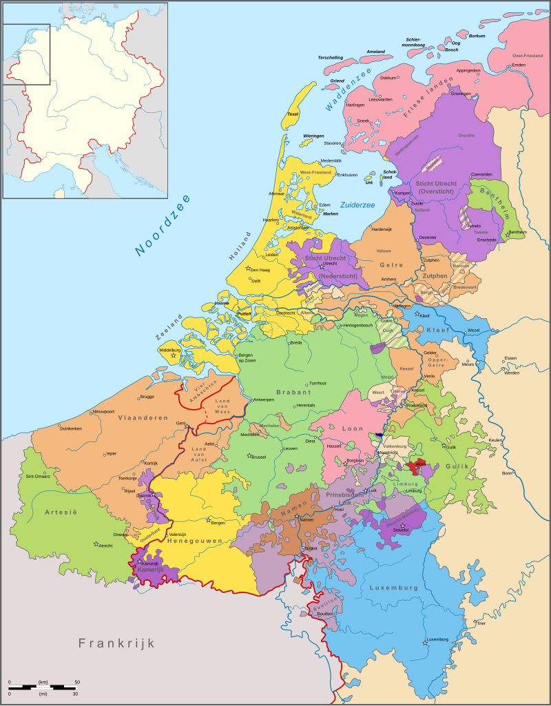
Provinces of the Republic of the Netherlands in the 1600s: I would use these borders for the provinces
800px-Republiek_der_Zeven_Verenigde_Nederlanden.svg.png

P.S. I know everyone has their own regions they'd like to see improved and I think it's great everyone makes suggestions for different parts of the world: so please don't turn this into another discussion about which other part of the world should be improved FIRST.

Edit 6 March: See the map below for a visualisation of these 4 changes. One small addition: since the small province of Utrecht loses some territory to Gelre, it should be expanded a little bit in the West (give it a tiny part of Holland) to keep it clickable. Moreover, this also corresponds to the two maps above!

winsEG6.png

Edit (6 March): see the discussion below for other possible changes that have been proposed. Notably: adding Upper-Gelre/Roermond, dividing Holland into 2 provinces, adding Tournai in the Flanders region.

uYHsT7G.png
 
Last edited:
Upvote 0
What about cutting Breda into Den Bosch and Eindhoven? With Brabant being cut into Mechelen, Leuven, and Brussels? This way we also balance the Belgium-area of the Lower Countries.
 
As provinces are the basic units in the game, I don't think it's feasible to propose cutting them down to the level of cities and towns.

Also I wouldn't propose cutting provinces that are perfectly fine as they are, just for the sake of having more provinces. The changes I proposed are meant to enhance both accuracy and gameplay. That's why I took the Seventeen Provinces as guideline for the provinces in the Low Countries: these were all historical administrative units.

(BTW: as I said before, Eindhoven was really quite insignificant in this timeframe. It only became one of the biggest cities in the Netherlands over the course of the twentieth century...)
 
When making suggestion remember that:

1. Be clear with the suggestions, so if like many suggestion are collect one should update the thread.
2. Try not to overdo it, we know that it would be perfect if all or most of the provinces of the Netherlands can be represented, but is it worth it? Drenth is small and poor, it can easily be included into Overjissel. While Holland could actually be divided!

As provinces are the basic units in the game, I don't think it's feasible to propose cutting them down to the level of cities and towns.

Also I wouldn't propose cutting provinces that are perfectly fine as they are, just for the sake of having more provinces. The changes I proposed are meant to enhance both accuracy and gameplay. That's why I took the Seventeen Provinces as guideline for the provinces in the Low Countries: these were all historical administrative units.

(BTW: as I said before, Eindhoven was really quite insignificant in this timeframe. It only became one of the biggest cities in the Netherlands over the course of the twentieth century...)
Yeah personally, I´d add Oversticht and divide Holland into 2, for the new provinces.


Groningen maybe but I really don´t see it being added, it´s on the same country and is not as compelling.


Of course the suggestion can be made, but I fear that seeing 4 provinces suggestion might "scare" devs away from even adding 2 or 1. Not sure if this is true, @Trin Tragula , is it true what I think/said?
 
As provinces are the basic units in the game, I don't think it's feasible to propose cutting them down to the level of cities and towns.

Also I wouldn't propose cutting provinces that are perfectly fine as they are, just for the sake of having more provinces. The changes I proposed are meant to enhance both accuracy and gameplay. That's why I took the Seventeen Provinces as guideline for the provinces in the Low Countries: these were all historical administrative units.

(BTW: as I said before, Eindhoven was really quite insignificant in this timeframe. It only became one of the biggest cities in the Netherlands over the course of the twentieth century...)


These additions are to boost the wealth, population, and development of the Netherlands so that it can be more capable of holding its own against its bigger neighbors.
 
These additions are to boost the wealth, population, and development of the Netherlands so that it can be more capable of holding its own against its bigger neighbors.
Does it need though? Netherlands never were able to hold against their big enemies by themselves really, they always had allies because they were helpful in weakning many people´s enemies.
 
@Zerodv

Right, I agree that proposing to add a very large number of provinces could be counter-productive: that's why I just proposed 4 changes in my original post (of which 3 new provinces and 1 simple border correction between existing ones).

But because I understand that might already be too demanding, I also put the suggestions in the order from most important to least important (in my highly subjective view): I agree with you that Oversticht is the most important new province that should be added.

As for Holland: I understand splitting the province could be interesting because of the concentration of important cities there. But I don't see why dividing Holland should have priority over Groningen, Drenthe, or even Upper-Gueldres (Roermond area). The province was always one united administrative area, in contrast to those others. So while I'd welcome the division, I'd give it lower priority than the other proposed provinces, all of which add more accuracy.
 
Does it need though? Netherlands never were able to hold against their big enemies by themselves really, they always had allies because they were helpful in weakning many people´s enemies.

They are always absorbed severely during their revolt in the game. This can be solved by giving them a few more provinces that switch to their side quickly or having event-spawned rebels appearing to help out as well.
 
@Zerodv

Right, I agree that proposing to add a very large number of provinces could be counter-productive: that's why I just proposed 4 changes in my original post (of which 3 new provinces and 1 simple border correction between existing ones).

But because I understand that might already be too demanding, I also put the suggestions in the order from most important to least important (in my highly subjective view): I agree with you that Oversticht is the most important new province that should be added.

As for Holland: I understand splitting the province could be interesting because of the concentration of important cities there. But I don't see why dividing Holland should have priority over Groningen, Drenthe, or even Upper-Gueldres (Roermond area). The province was always one united administrative area, in contrast to those others. So while I'd welcome the division, I'd give it lower priority than the other proposed provinces, all of which add more accuracy.
Maybe it´s not counterproductive, we should ask the dev, I have the feeling it is but I might be wrong.


About Holland: Even as single unit the importnat of representing the Hollandic importance goes over Drenthe at least, Groningen less so. The defensivness value of it is bigger and also you could increase or represent the development better there. But really if had the choice I would add them all, LOL.


Any idea on what could be changed in term of trade goods or terrain? Marshes in the Netherlands are a bit too harsh IMO.
 
Last edited:
Quick answer. I was just browsing a book (Manors and markets : economy and society in the Low Countries, 500-1600 / Bas van Bavel, 2010) to learn about trade goods in the area.

Basically, Gelre, Overijssel en Drenthe could all produce either grain or wool. If Holland is divided into 2 provinces, one should keep the tradegood fish, while the other one could get textile.

According to Van Bavel, Holland was already heavily industrialised (especially textile production) in 1514:
In Holland as a whole, town and countryside, only 25 per cent of labour was engaged in agriculture, supplying less than 20 per cent of GDP. If fishing and peat digging are included, the primary sector still involved no more than 39 per cent of labour, generating only 31 per cent of GDP. Industry accounted for 38 per cent of the labour force and 39 per cent of GDP, and services for 22 per cent and 30 per cent, respectively. This is a very exceptional economic structure for late medieval western Europe: before the Industrial Revolution, on average 80 per cent of the European population were engaged in agriculture. The share of GDP earned in industry in early 16th‐century Holland, 39 per cent, was at a level not attained elsewhere in Europe until the beginning of the 20th century, even in England and Germany.

As for the marshes: I tend to agree with you that it's too harsh, especially in the mid- and end-game. Dikes were built in the 12th and 13th century, but large parts of the Netherlands were still quite swampy in 1444. This changed over the course of the early modern era: the lands were changed into farmlands. It’s unfortunate that EU IV doesn’t simulate this, because it’s strange indeed to see half of the Netherlands as marshes in the eighteenth century.
 
Quick answer. I was just browsing a book (Manors and markets : economy and society in the Low Countries, 500-1600 / Bas van Bavel, 2010) to learn about trade goods in the area.

Basically, Gelre, Overijssel en Drenthe could all produce either grain or wool. If Holland is divided into 2 provinces, one should keep the tradegood fish, while the other one could get textile.

According to Van Bavel, Holland was already heavily industrialised (especially textile production) in 1514:


As for the marshes: I tend to agree with you that it's too harsh, especially in the mid- and end-game. Dikes were built in the 12th and 13th century, but large parts of the Netherlands were still quite swampy in 1444. This changed over the course of the early modern era: the lands were changed into farmlands. It’s unfortunate that EU IV doesn’t simulate this, because it’s strange indeed to see half of the Netherlands as marshes in the eighteenth century.

Events could appear where the geography of the land is changed from swamp to grassland.
 
For a suggestion I prefer to keep it as detailed and thourough as possible, I don't think doing that is "asking too much" cause these are just suggestions, the korea revamp that was recently done were very thourough indeed which gives Korea a good, satisfying feeling of being "done", at least within the current scope of the game.
The reason also why I'd like to see more provinces is due to increased dynamics in the region, more provinces to conquer, and especially not having Utrecht and Gelders as OPM to be annexed at best possible time. But I'll write a more thourough explanation of every point of conflict to make my point more clear.

Generally about some parts of the low countries I feel some provinces are a bit richer than they should be but at the same time (despite this) some countries are weaker than they should be cause they only got one province. Splitting dev between more provinces but in general increasing dev points of the countries appears to be more realistic to me.

I also don't know who exactly I'm writing this to, since there's been a lot of post since my last post. It's just a further argumentation for why the provinces could be included in the game.

1. West Friesland - There was a debatte whether to split Holland into the modern day provinces of North/South Holland which were met with soem critic that Holland were never divided administratively like that and it would reduce the individual development of the hollandic provinces (since dev probably wouldn't slap another 20 dev or so out of nowhere in Holland). West Friesland fullfill the critera of having been treated as a separate part of Holland and had status similiar to a province. It'd be a low dev province, it could even be made so that Hollands dev isn't increased and 4-5 dev are moved primarily from Zeeland (which from what I gather wouldn't be that rich in the EUIV timeframe) It'd also make it possible as was mentioned making the Holland province more valuable by having textile as a trade goods, with fish moved to west friesland.
read this part of wikipedia for the historical circumstances: https://en.wikipedia.org/wiki/West_Friesland_(region)#History

2. Groningen should be an independent merchant republic, historically accurate and an interesting addition to the game.

3-4. OverIjissel and Drenthe cold be one province but for depth of action and detail I'd prefer them separatly.

5-6. I thought there were fairly good possibility to split lower gelre into two provinces, it'd fit the map well and Zutphen had been an independent county which been in a personal union with Gelre. Makes for a more dynamic gameplay both playing Geldern and conquering Geldern and administring the low countries.

8. Borders should obviously be drawn better, with more detail.

9-10. Just more historically accurate and would create more gameplay in the region and make for good balance I dare say.

11. Problem with current Limburg is that the province is based on modern era Limburg which doesn't make sense whatsoever in 1444. The town of Limburg isn't even located in modern day Limburg but in the Belgian province of Liege. Completly different shape in 1444 for the Brabantian influenced lands around the Maas and should be better represented.

If people want to double checkagainst my map again I'll include it in this post again.

20170305225644_1.jpg
 
Julich could be made wider by taking some of the land in the Coblenz province. I don't think the developers will make a snake like province. They might as well stretch #7 down so that it touches #11.
 
can someone like they one of those well done HRE map, cut the region specific and color the map so that all the small enclaves, exclaves and so on get simplified, so to give both a historical and viable in-game form to the suggest provinces, I think it´s a good way of illustrating rather than in-game colored maps.
 
can someone like they one of those well done HRE map, cut the region specific and color the map so that all the small enclaves, exclaves and so on get simplified, so to give both a historical and viable in-game form to the suggest provinces, I think it´s a good way of illustrating rather than in-game colored maps.

Here are some reshapings some people have done:

c6NAMgK.png


2qw06mw.jpg
 
@Trin Tragula Would you say this makes a strong enough case to improve the low countries? They could really do with a revamp to more accurately depict the region of the time.

We appreciate any thread with suggestions for the map of the regions our game cover and as always I follow the discussion with interest.
However we are not at this time looking to improve the European map. 1.20 will focus on east Asia.
If/when we do touch up Europe again we will revisit all threads like these for inspiration.
That said I also want to mention the Low Countries and the Rhine area currently have the highest province densities in the game. In some cases the reason we don't cover certain things is that we don't believe we have space to do it in an acceptable way for vanilla. The map is this games most important interface and needs to be clear enough to read and clickable enough to use in all places.
This is why we have never added Jüllich for instance. Much as I'd love to see it in the game.

Any way to let us know ahead of time so we can prepare our suggestions?
 
@Trin Tragula
Thank you for your reply. Too bad no improvements can be made to this region for this patch, but hopefully you'll consider it for a next one. :)

I understand and fully agree with you clickability concern. That's also why I only proposed provinces that would all be bigger than the current province of Utrecht.

Anyway, if only a very limited change could be made because you don't want to further increase the province density here, I'd just go for the border correction around Utrecht (no new province needed for this one) and 1 new province: Oversticht (owned by Utrecht). I think this new province would make a 1444 start with Utrecht more interesting and change the dynamics in this area.

(that would be Overijssel en Drenthe on the map below, together combined as one province)

uYHsT7G.png