Ok, I´ll start with the border stuff.
First, the "flattening" of Brazil is REALLY severe and annoying. I actually think the whole continent is afected by the problem, but Brazil get´s it worst than the other countries. It makes my country looks like a fat lady

. I can´t really sugest where to redraw the border because the shape of the continent and the way Brazil fits in it makes it almost impossible without a complete redraw.... I have to ask OHgamer and anyone else that is involved in this: Is there any chance that we can at least remedy this problem to a degree? Or are we going to have to live with it?
Second, the province of "Santa Barbara" in the game (2105) should be in Brazil. I just noticed it is the modern-state of Roraima. I don´t know what the heck it´s doing in Venezuela. This is a SERIOUS flaw (and I´m ashamed to not have noticed it before
). In the 1914 scenario it is correctly in Brazil, but I´m 100% sure it was part of Brazil since the Treaty of Madrid (1750). The only land-grabs Brazil made after that were the Seven Missions in 1801, the buying of Acre and little bits of Paraguay. Returning it to Brazil will correct most of the problems with the borders with the Guyanas and Venezuela.
Following. The Brazilian-Colombian border is wrong. It´s nothing major, but what I´ve outlined above will make it better.
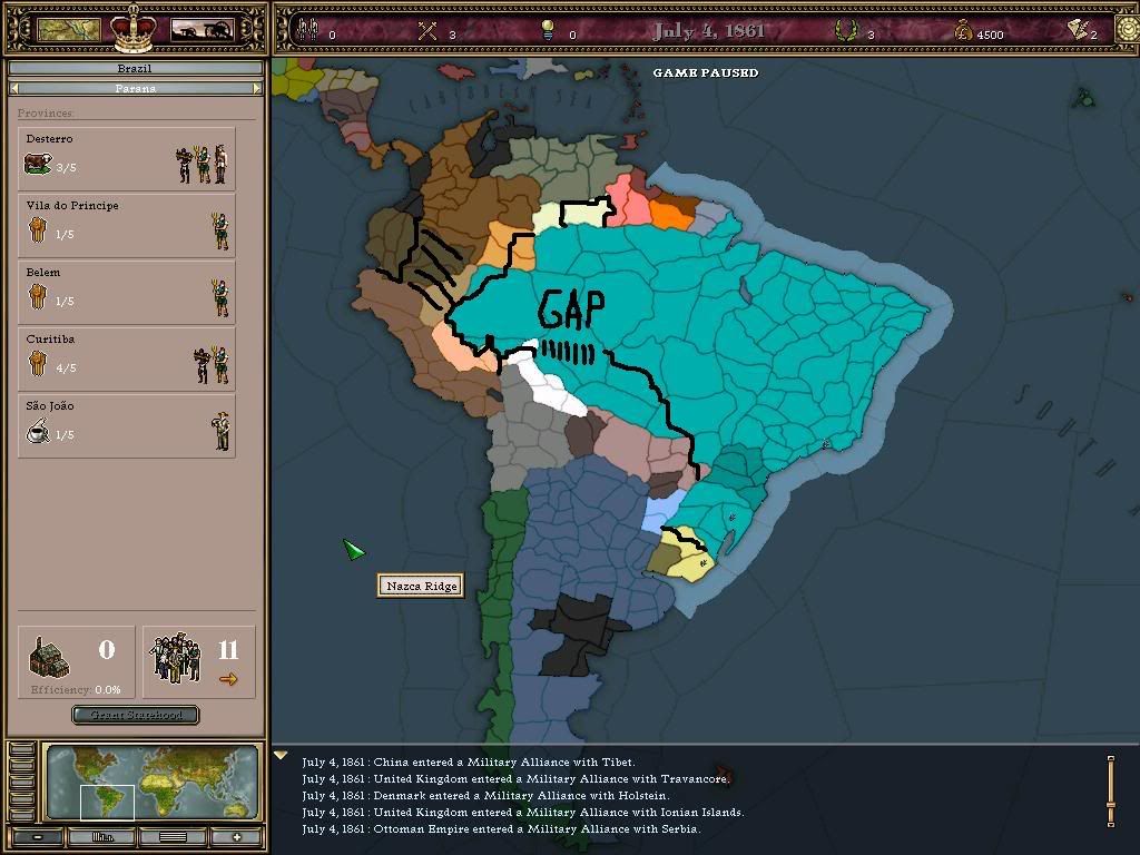
Now, the really bad part. Bolivia and Paraguay. I can´t honestly say how to correct it. The real problem here is because the proportions are screwed, so instead of Brazil´s border following a mostly vertical line from the triple frontier (between Argentina, Brazil and Paraguay) up to the northern point of the Brazil-Bolivia border, it follows a mostly horizontal line. I´ve drawn a line from the point of the triple frontier more or like the real frontier should be, but the line doesn´t close where it should, there´s a gap that I´ve marked with my not-so-handsome writing. I´m showing the problem, but I don´t know how to correct it without redrawing most of the continent.
The brazilian-uruguayan frontier is mostly straight, it doesn´t have that "pocket" of Uruguay. I´ve made a line that corrects that.
Now, for the other countries. The Venezuelan-Colombian frontier looks nice to me, so let´s leave at it.
Ecuador promises to be a big headache, tough. It is MUCH bigger than today in Vicky. Even with the province they are supposed to loose to Peru, it looks too big. I know the two countries have had a history of border disagreement and perhaps Ecuador really was bigger than today. We will need to look into that, but it seems that a lot of territory was Ecuatorian in name but Peruvian in fact, and that situation was ratified in the 1936 agreement and the 1941 war. I´ve drawn a modern border there, to illustrate the difference. I don´t know how much of the territory I´ve marked should be given to Peru and what should stay with Ecuador, but it needs changing.
Bolivia borders looks okay with Chile and Peru and I´ve already talked about the border with Brazil. The paraguayan border will need checking, since they too had border disputes and a war there and we will need to discover what was the status quo in 1836.
Paraguay definetly looks odd and not very much like today, but it´s the hardest one to correct. Primarily, because it lost a lot of territory in the Triple Alliance War and we need to check a good atlas to see what they had back then. They also disputed territory with Bolivia. And being located squarely in the middle of the continent transform it in a sort of "cushion" that absorb all the deformities of the other countrie´s borders, mainly Brazil. I´ve didn´t touched it because of this.
Argentina also looks a little "fat", like Brazil, but the problem is much less severe. It seems a little bit too big to my eyes too, but I don´t think it´s much off and perhaps doesn´t need any changing. It has a LOT of provinces, tough. But, well, Generalissimo can come in here and speaks much better than I about his country, so let´s leave it to him.
If we want to portray a better geography, we must make Chile even thinner. It is VERY thin in RL, and some of those provinces are too big. I don´t know if it will affect clickability, but we should make them a little less fat, at least.