We have updated our Community Code of Conduct. Please read through the new rules for the forum that are an integral part of Paradox Interactive’s User Agreement.
You are using an out of date browser. It may not display this or other websites correctly. You should upgrade or use an alternative browser.
@MTGian Can't some of the divergence between GAEZ and historical data be explained by sociopolitical factors and not climatological ones? Your argument implicitly assumes that all countries were exploiting their agricultural potential equally well, which would make the discrepancy between GAEZ and historical data quite challenging for GAEZ. However, it may have been that England was simply operating much closer to the production possibility frontier than Spain was in the same period. As an example - English agricultural efficiency grew dramatically as a result of the enclosure movement, ending the open-field system, but this at the same time caused huge social upheaval and required a powerful and capable state to enforce and to quell unrest. If the enclosure movement had never happened, which it might not have done without such a powerful and centralized state, English agricultural productivity would have been lower notwithstanding that the climate conditions were the same.
Could it not simply be the case for some of the discrepancy that English agriculture was more productive because of these kinds of sociopolitical reasons, which are not captured by the climate system and should not be attempted to be captured b the climate system?
I'd like to hear your thoughts on this. This pattern of cold and dry weather seems utterly bizarre to all Chinese people, yet it appears to be the consensus across international online communities.
There are also many issues with climate classification.
I know that the climate of EU5 is based on Köppen, but modern climate should not be used.
It is too rigid in dividing different climates, especially in modern times due to the influence of urban heat island effect, which may lead to the fragmentation of areas with small differences in temperature and precipitation within the same geographical area into two different climates.
These cold arid regions are almost indistinguishable from the surrounding terrain and climate, but are rigidly divided. Especially in climate maps drawn with reference to other climate classification methods, these areas are located in monsoon regions with semi humid areas with precipitation greater than 400mm, and there is no significant difference in temperature and precipitation compared to surrounding areas. This almost divides several modern cities and surrounding areas into different climates, but as is well known, there was no Industrial Revolution in 1337.
Here are some maps of other climate related data that can prove that there is no significant climate difference between these areas and the surrounding areas.
Apologies for not responding right away. I've been busy with work and these posts take time to put together.
Two things:
1) I've expressed skepticism over the GAEZ maps producing results that at least to my eyes make large parts of Iberia appear relatively similar in agricultural potential to large parts of England. If possible, I want to stress this skepticism strongly enough that everyone shares it.
The following are excerpts from "Spanish Agriculture: The Long Siesta, 1765 - 1965" by James Simpson (Professor at Charles III University of Madrid).
I've guessed that the Agricultural Revolution might have been more difficult without seasonal rainfall (because of fewer seasons to plant crops and low concentration of livestock). Simpson says as much in this passage and also that yields in northern Europe were three times those of Spain by the end of the period.
One major step in avoiding the Malthusian threat is usually considered to be the Agricultural Revoluion of northwest Europe. This was such innovations as the planting of forage crops in the fallow, especially legumes and turnips, and the introduction of convertible husbandry using commercially-produced grass seeds. Both allowed a much greater density of livestock and its better integration with arable cultivation. These changes helped improve the nitrogen content of soils, producing in turn higher cereal yields. The success was by no means limited to England. the diffusion of one or more of the techniques involved in raising the nitrogen level of soils had allowed, according to one historican, wheat yields in 'Ireland, northern France, Holland, and probably western Germany and Belgium' to be similar to those achieved in England around 1800. At an assumed yield of 1.58 tons a hectare (22.5 bushels an acre), these northern regions enjoyed levels almost twice those that Spain would experience a century later. When allowance for the much greater quantity of unsown fallow that was needed in Spain is also taken into the comparison, then northern Europe was producing about three times as much wheat per hectare as Spain, and a century earlier.
This startling contrast in yields is the single most important difference in traditional agriculture between Spain (or the Mediterranean in general) and northwest Europe. It was not caused by the ignorance of Spanish farmers of the new methods, but by the difficulties in introducing intensive farming rotation to a country with low rainfall and without irrigation. I will explore the nature of technical change in dry-farming later in the book. Meanwhile, the low summer rainfall implied that the First Agricultural Revolution would not be feasible over most of Spain.
Here are some sections where Simpson discusses the challenges in Spain. He mentions some of the things that I have pointed out - low livestock densities (which made for less fertilizer), winter planting season instead of summer, longer fallow periods to maintain moisture, less rainfall meant for poor pasture (explaining the low livestock densities), and mixed farming being more difficult.
Contemporaries provided a number of explanation for the poor performance of Spanish agriculture described in chapter I, with unfavourable topography, poor soils, inclement climate, and an 'inefficient' property distribution being the most frequently cited. This chapter is divided into three sections. In the first, I examine some of the consequence of resource endowments. In particular, the presence of summer drought over much of the Peninsula meant that dry-farming methods were used, and livestock densities were low.
After Switzerland, Spain is Europe's highest country, with 18.4 percent of the land mass above 1,000 meters, and only 11.4 per cent found between 0 and 200 metres, the optimal height for agricultural purposes. Climatically, the country divided into two broad areas, with the north and northwest receiving between 30 and 45 inches (760 - 1140 millimetres) of rain annually and, expect in the mountains, enjoying relatively mild temperatures. Over large areas of the rest of the country, rainfall is often under 20 inches (less than 500 millimetres), although of greater importance for agricultural is the seasonal distribution, with the summer months experiencing long droughts. Dought, combined with the high temperatures, severely limits the choice of crops, and has made intensive cultivation impossible except where irrigation can be practised. Outside the North, extremes of winter temperature are marked by the limits for olive culivation, which is roughly south of a horizontal line going through Madrid, together with north-eastern Spain (especially the Ebro valley). Finally, except along the Mediterranean coast, the risk of frosts limits crop choice.
If not the sole factor, climatic factors and especially summer droughts have played a major role in determining crop mix, livestock densities, and farming systems. As table 2.1 shows, Spanish agriculture in 1910 was very different from that of northwest Europe. First, the relative importance of arable was much greater in the Mediterranean countries, a factor which, until very recently, was reflected in the extremely low per capita meat consumption. Second, fruit, nuts, wine, and olive oil were much more prominent in the Mediterranean than in the North. Lastly, cereals were especially important in Spain.
Specialisation in cereals and legumes need not by itself imply inefficiency if the country had a comparative advantage in their production. However, this was not so in Spain. Most cereals in Spain were grown under conditions of dry farming, so much so that one agronomist noted that if Spanish farmers had written about their own farming techniques, the world would have used the word secano, instead of dry-farming. Dry-farming can be defined as growing crops under semi-arid conditions where moisture is deficient and which require special cultivation methods. In the case of Spain, special cultivation methods were required in almost all non-irrigated areas outside the North, about four-fifths of the country's land mass. Dry-farming cereal had three main characteristics: the need for winter rather than spring planting; a period of fallow of one or two years after each crop to 'conserve' moisture; and the need to carefully maintain the depth of tillage, especially in the spring, to avoid moisture loss. The unsown land provided sparse pasture for livestock, which in turn produced virtually the only fertiliser that the soil would receive.
Summer droughts also resulted in poor quality animals and low livestock densities. The large areas of empty and initially turbulent lands in central Spain led to the founding of the Mesta in 1273, an institution which North and Thomas, among others, have identified as a major cause of Spanish agricultural backwardness. The Mesta was a transhumant organisation, allowing sheep to graze the winter pasture of Extremadura and the Sierra Morena, and the summer pasture of the foothills of the Cantabrian mountains and other upland areas of the northern Interior. by using two different geographical regions, separated by three or four hundred miles, relatively large numbers of sheep could be kept. The lad led one recent study to stress the postiive value of the institution, namely its ability to achieve efficient property rights for grazing. The establishment of canadas (designated sheep walks) kepy the animals away from crops, and special courts existed to deal with the problems caused by straw animals. Furthermore, and in contrast to what North and Thomas believe, sufficient land existed to make the Mesta compatible with arable farming until the late eighteenth century. By then, as chapter 3 argues, under the influence of population growth, the Mesta's usefulness began to be widely questions, and it quickly lost its powers, eventually disappearing in 1836. If the role of the Mesta in Spanish agriculture needs to be re-examined in a much more favouarble light, it still needs to be stressed that transhumant sheep farming was totally incompatible with mixed husbandry. Everywhere outside the North, farmers found it almost impossible to maintain high livestock densities for mixed farming on unirrigated soils, and this lack of grazing helps to explain why, by the twentieth century, miles were the principal work animals over much of Spain's secano (maps 3 and 4).
If you read all of that and say to yourself, "Spain didn't face challenges that made it categorically different from England", then we can just agree to disagree.
2) I believe that I have found the smoking gun to my concerns over GAEZ.
Here is an excerpt from Theme 3: Agro-climatic Potential Yield:
"Crop specific requirements are matched with temperature regimes prevailing in individual grid-cells. Matching is tested for the full range of possible starting dates. For rain-fed conditions the crop calendar resulting in the highest expected (water-limited) yield is selected to represent maximum biomass and agro-climatic potential yield of the respective crop in a particular grid-cell. The estimation of yield losses due to water stress is based on crop-specific water balances. Yield estimation for irrigation conditions assumes that irrigation is scheduled such that no yield-reducing crop water deficits occur during the crop growth cycle."
I think this explains the problem. GAEZ is focused on identifying the best yield that you could possibly achieve regardless of timing. So, the wheat yield that it produces for Spain is planted over the winter rainy season, while the wheat yield that it produces for England is planted over the summer season. Those not being terribly far apart isn't shocking to me. Summers in England are maybe not terribly different than winters in Spain when it comes to conditions.
However, that is not the overall agricultural productivity of the place. That does not take into account any of the factors listed above. It doesn't take into account that England can plant a summer *and* a winter crop, while Spain only gets the one winter crop. The effect of that was that Spain only did a 2-field crop rotation (50% fallow), while England did a 3 or more-field (33% fallow at the most). It also doesn't take into account the low livestock densities, less fertilizer, etc, etc.
I keep saying that GAEZ is missing something. This is what it is missing. The numbers that it produces are a great *starting point* for yields, but we need to layer some things on top of it. There probably needs to be a penalty to agrarian yields (to reflect fewer seasons and the larger fallow) and a penalty to amount of livestock (to reflect less overall/seasonal greenery). This would also penalize fertilizer production. On top of that, there needs to be a penalty to adoption of Agricultural Revolution technologies.
The penalties could be cancelled out with irrigation. However, irrigation should either be difficult (more expensive) or impossible in places where there wasn't a source of water. I researched this at one point and that actually covers a fairly large portion of Spain. There either weren't nearby rivers or rivers were in recessed canyons, so it wouldn't be easy to move the water to farming areas. The Spanish weren't dumb. The agriculture problem was actually difficult to solve. The same should be true for the person who plays as Spain.
Rainfall has nothing to do with what is being represented in the table: the table purely considers percentage of fallow duration in terms of soil fertility (i.e. nutrient availability). The only way rainwater matters for this table is through leaching of soils. Soil type is the primary factor for the numbers in this table.
I'm not sure this is worth arguing about because you could make a practical argument for why Mediterranean countries would do a 2-field rotation instead of 3-field when they only had one planting season - it takes time to plant a field. So, in England, farmers would only have to plant 1/3 of their field in spring, then another 1/3 in fall. The work is distributed over the year. If farmers in Spain wanted to do a 3-field, then they would have to plant 2/3 of their field all at once during the one winter season.
However, I buy the argument that drier conditions would make for drier, lighter soils, which could be worked less often. Simpson says that above and I've read that elsewhere as well. If GAEZ is not including the effect of a long dry season in the fallow percentage, then that seems wrong to me.
That said, I absolutely believe England indeed had higher outputs than spain, but when trying to identify global, general trends to apply for in game use, the agro-climatic yields provide a solid basis. In spain there's just
As I said above, I think the GAEZ maps are a great starting point to use a basis for agricultural production, but I think we need to layer some other systems on top of it.
@MTGian Can't some of the divergence between GAEZ and historical data be explained by sociopolitical factors and not climatological ones? Your argument implicitly assumes that all countries were exploiting their agricultural potential equally well, which would make the discrepancy between GAEZ and historical data quite challenging for GAEZ. However, it may have been that England was simply operating much closer to the production possibility frontier than Spain was in the same period. As an example - English agricultural efficiency grew dramatically as a result of the enclosure movement, ending the open-field system, but this at the same time caused huge social upheaval and required a powerful and capable state to enforce and to quell unrest. If the enclosure movement had never happened, which it might not have done without such a powerful and centralized state, English agricultural productivity would have been lower notwithstanding that the climate conditions were the same.
Could it not simply be the case for some of the discrepancy that English agriculture was more productive because of these kinds of sociopolitical reasons, which are not captured by the climate system and should not be attempted to be captured b the climate system?
There were other factors, definitely. Parts of northern Spain had minifundios, which are micro-sized plots. This created all kinds of challenges for agricultural productivity and technological adoption. Large parts of southern Spain had latifundios, which were a legacy of the Reconquista. These were very large estates held by nobles and ecclesiastical organizations. These organizations employed peasants to work the land. They tended to be conservative, which slowed adoption of new methods.
Here are some excerpts on land ownership/tenurial systems by Simpson:
Contemporaries and, more recently, historians have emphasised not only the poverty of Spain's natural resources as a limitation to agricultural progress, but also a supposed sub-optimal distribution of property. According to Malefakis, land ownership in Spain had two major characteristics:
a) the predominance of either very large or small holdings, with an absence of holdings large enoguh to maintain comfortable, but not excessively, a peasant family, and
b) a marked regional difference in the distribution of the two extremes: small holdings being found in the north and centre of the country, and large farms in the south.
Malefakis defines small as below 10 hectares and large as above 100, a division that he admits has limitations without knowledge of land quality or cropping systems. Despite this problem, Malefakis reinforced what contemporaries had generally believed, that the pocket handerchief plots of Galicia, the fragmented farms of Castilla-Leon, and the undercapitalized latifundios of large areas of Andalucia, Extremadura, and La Mancha, all created institutional barriers to the modernisation of the sector.
However, it was the latifundios in southern Spain, and especially Andalucia, which caused the main 'agrarian problem' prior to the Civil War. Owners of the latifundios were often absentee, and the property leased in large units and on short leases, to a lreatively small tenant class. Cultivation was then carried out by joraleros, temporary workers, who numbers tended to exceed demand except during the harvest.
The problem of small holdings was most acute in the North, and in particuolar in Galicia, in the extreme northwest. In Galicia, it was not just the minute and fragmented owvership, but until the twentieth century, also the frequent division of ownership of the dominuim utile and directum. One example, not atypical, was a 'field' found in Mera (La Coruna) which measured 32 square metres and on which three people owned indefinite property rights: one had the use of the land, another the chestnut tree to be found on it, and a third, received as rent six eggs annually, being paid alternately by the farmer who worked the land and by the 'owner' of the chestnut tree.
So, there were definitely other challenges that were heaped on top of the climatic issues, but there definitely were climatic issues. To ignore them would not be accurate.
Tables and Maps that may be of interest. These are all from well after the game period was over, but they are probably representative of at least the second half of the game period.
Apologies for not responding right away. I've been busy with work and these posts take time to put together.
Two things:
1) I've expressed skepticism over the GAEZ maps producing results that at least to my eyes make large parts of Iberia appear relatively similar in agricultural potential to large parts of England. If possible, I want to stress this skepticism strongly enough that everyone shares it.
The following are excerpts from "Spanish Agriculture: The Long Siesta, 1765 - 1965" by James Simpson (Professor at Charles III University of Madrid).
I've guessed that the Agricultural Revolution might have been more difficult without seasonal rainfall (because of fewer seasons to plant crops and low concentration of livestock). Simpson says as much in this passage and also that yields in northern Europe were three times those of Spain by the end of the period.
One major step in avoiding the Malthusian threat is usually considered to be the Agricultural Revoluion of northwest Europe. This was such innovations as the planting of forage crops in the fallow, especially legumes and turnips, and the introduction of convertible husbandry using commercially-produced grass seeds. Both allowed a much greater density of livestock and its better integration with arable cultivation. These changes helped improve the nitrogen content of soils, producing in turn higher cereal yields. The success was by no means limited to England. the diffusion of one or more of the techniques involved in raising the nitrogen level of soils had allowed, according to one historican, wheat yields in 'Ireland, northern France, Holland, and probably western Germany and Belgium' to be similar to those achieved in England around 1800. At an assumed yield of 1.58 tons a hectare (22.5 bushels an acre), these northern regions enjoyed levels almost twice those that Spain would experience a century later. When allowance for the much greater quantity of unsown fallow that was needed in Spain is also taken into the comparison, then northern Europe was producing about three times as much wheat per hectare as Spain, and a century earlier.
This startling contrast in yields is the single most important difference in traditional agriculture between Spain (or the Mediterranean in general) and northwest Europe. It was not caused by the ignorance of Spanish farmers of the new methods, but by the difficulties in introducing intensive farming rotation to a country with low rainfall and without irrigation. I will explore the nature of technical change in dry-farming later in the book. Meanwhile, the low summer rainfall implied that the First Agricultural Revolution would not be feasible over most of Spain.
Here are some sections where Simpson discusses the challenges in Spain. He mentions some of the things that I have pointed out - low livestock densities (which made for less fertilizer), winter planting season instead of summer, longer fallow periods to maintain moisture, less rainfall meant for poor pasture (explaining the low livestock densities), and mixed farming being more difficult.
Contemporaries provided a number of explanation for the poor performance of Spanish agriculture described in chapter I, with unfavourable topography, poor soils, inclement climate, and an 'inefficient' property distribution being the most frequently cited. This chapter is divided into three sections. In the first, I examine some of the consequence of resource endowments. In particular, the presence of summer drought over much of the Peninsula meant that dry-farming methods were used, and livestock densities were low.
After Switzerland, Spain is Europe's highest country, with 18.4 percent of the land mass above 1,000 meters, and only 11.4 per cent found between 0 and 200 metres, the optimal height for agricultural purposes. Climatically, the country divided into two broad areas, with the north and northwest receiving between 30 and 45 inches (760 - 1140 millimetres) of rain annually and, expect in the mountains, enjoying relatively mild temperatures. Over large areas of the rest of the country, rainfall is often under 20 inches (less than 500 millimetres), although of greater importance for agricultural is the seasonal distribution, with the summer months experiencing long droughts. Dought, combined with the high temperatures, severely limits the choice of crops, and has made intensive cultivation impossible except where irrigation can be practised. Outside the North, extremes of winter temperature are marked by the limits for olive culivation, which is roughly south of a horizontal line going through Madrid, together with north-eastern Spain (especially the Ebro valley). Finally, except along the Mediterranean coast, the risk of frosts limits crop choice.
If not the sole factor, climatic factors and especially summer droughts have played a major role in determining crop mix, livestock densities, and farming systems. As table 2.1 shows, Spanish agriculture in 1910 was very different from that of northwest Europe. First, the relative importance of arable was much greater in the Mediterranean countries, a factor which, until very recently, was reflected in the extremely low per capita meat consumption. Second, fruit, nuts, wine, and olive oil were much more prominent in the Mediterranean than in the North. Lastly, cereals were especially important in Spain.
Specialisation in cereals and legumes need not by itself imply inefficiency if the country had a comparative advantage in their production. However, this was not so in Spain. Most cereals in Spain were grown under conditions of dry farming, so much so that one agronomist noted that if Spanish farmers had written about their own farming techniques, the world would have used the word secano, instead of dry-farming. Dry-farming can be defined as growing crops under semi-arid conditions where moisture is deficient and which require special cultivation methods. In the case of Spain, special cultivation methods were required in almost all non-irrigated areas outside the North, about four-fifths of the country's land mass. Dry-farming cereal had three main characteristics: the need for winter rather than spring planting; a period of fallow of one or two years after each crop to 'conserve' moisture; and the need to carefully maintain the depth of tillage, especially in the spring, to avoid moisture loss. The unsown land provided sparse pasture for livestock, which in turn produced virtually the only fertiliser that the soil would receive.
Summer droughts also resulted in poor quality animals and low livestock densities. The large areas of empty and initially turbulent lands in central Spain led to the founding of the Mesta in 1273, an institution which North and Thomas, among others, have identified as a major cause of Spanish agricultural backwardness. The Mesta was a transhumant organisation, allowing sheep to graze the winter pasture of Extremadura and the Sierra Morena, and the summer pasture of the foothills of the Cantabrian mountains and other upland areas of the northern Interior. by using two different geographical regions, separated by three or four hundred miles, relatively large numbers of sheep could be kept. The lad led one recent study to stress the postiive value of the institution, namely its ability to achieve efficient property rights for grazing. The establishment of canadas (designated sheep walks) kepy the animals away from crops, and special courts existed to deal with the problems caused by straw animals. Furthermore, and in contrast to what North and Thomas believe, sufficient land existed to make the Mesta compatible with arable farming until the late eighteenth century. By then, as chapter 3 argues, under the influence of population growth, the Mesta's usefulness began to be widely questions, and it quickly lost its powers, eventually disappearing in 1836. If the role of the Mesta in Spanish agriculture needs to be re-examined in a much more favouarble light, it still needs to be stressed that transhumant sheep farming was totally incompatible with mixed husbandry. Everywhere outside the North, farmers found it almost impossible to maintain high livestock densities for mixed farming on unirrigated soils, and this lack of grazing helps to explain why, by the twentieth century, miles were the principal work animals over much of Spain's secano (maps 3 and 4).
If you read all of that and say to yourself, "Spain didn't face challenges that made it categorically different from England", then we can just agree to disagree.
2) I believe that I have found the smoking gun to my concerns over GAEZ.
Here is an excerpt from Theme 3: Agro-climatic Potential Yield:
"Crop specific requirements are matched with temperature regimes prevailing in individual grid-cells. Matching is tested for the full range of possible starting dates. For rain-fed conditions the crop calendar resulting in the highest expected (water-limited) yield is selected to represent maximum biomass and agro-climatic potential yield of the respective crop in a particular grid-cell. The estimation of yield losses due to water stress is based on crop-specific water balances. Yield estimation for irrigation conditions assumes that irrigation is scheduled such that no yield-reducing crop water deficits occur during the crop growth cycle."
I think this explains the problem. GAEZ is focused on identifying the best yield that you could possibly achieve regardless of timing. So, the wheat yield that it produces for Spain is planted over the winter rainy season, while the wheat yield that it produces for England is planted over the summer season. Those not being terribly far apart isn't shocking to me. Summers in England are maybe not terribly different than winters in Spain when it comes to conditions.
However, that is not the overall agricultural productivity of the place. That does not take into account any of the factors listed above. It doesn't take into account that England can plant a summer *and* a winter crop, while Spain only gets the one winter crop. The effect of that was that Spain only did a 2-field crop rotation (50% fallow), while England did a 3 or more-field (33% fallow at the most). It also doesn't take into account the low livestock densities, less fertilizer, etc, etc.
I keep saying that GAEZ is missing something. This is what it is missing. The numbers that it produces are a great *starting point* for yields, but we need to layer some things on top of it. There probably needs to be a penalty to agrarian yields (to reflect fewer seasons and the larger fallow) and a penalty to amount of livestock (to reflect less overall/seasonal greenery). This would also penalize fertilizer production. On top of that, there needs to be a penalty to adoption of Agricultural Revolution technologies.
The penalties could be cancelled out with irrigation. However, irrigation should either be difficult (more expensive) or impossible in places where there wasn't a source of water. I researched this at one point and that actually covers a fairly large portion of Spain. There either weren't nearby rivers or rivers were in recessed canyons, so it wouldn't be easy to move the water to farming areas. The Spanish weren't dumb. The agriculture problem was actually difficult to solve. The same should be true for the person who plays as Spain.
I'm not sure this is worth arguing about because you could make a practical argument for why Mediterranean countries would do a 2-field rotation instead of 3-field when they only had one planting season - it takes time to plant a field. So, in England, farmers would only have to plant 1/3 of their field in spring, then another 1/3 in fall. The work is distributed over the year. If farmers in Spain wanted to do a 3-field, then they would have to plant 2/3 of their field all at once during the one winter season.
However, I buy the argument that drier conditions would make for drier, lighter soils, which could be worked less often. Simpson says that above and I've read that elsewhere as well. If GAEZ is not including the effect of a long dry season in the fallow percentage, then that seems wrong to me.
As I said above, I think the GAEZ maps are a great starting point to use a basis for agricultural production, but I think we need to layer some other systems on top of it.
There were other factors, definitely. Parts of northern Spain had minifundios, which are micro-sized plots. This created all kinds of challenges for agricultural productivity and technological adoption. Large parts of southern Spain had latifundios, which were a legacy of the Reconquista. These were very large estates held by nobles and ecclesiastical organizations. These organizations employed peasants to work the land. They tended to be conservative, which slowed adoption of new methods.
Here are some excerpts on land ownership/tenurial systems by Simpson:
Contemporaries and, more recently, historians have emphasised not only the poverty of Spain's natural resources as a limitation to agricultural progress, but also a supposed sub-optimal distribution of property. According to Malefakis, land ownership in Spain had two major characteristics:
a) the predominance of either very large or small holdings, with an absence of holdings large enoguh to maintain comfortable, but not excessively, a peasant family, and
b) a marked regional difference in the distribution of the two extremes: small holdings being found in the north and centre of the country, and large farms in the south.
Malefakis defines small as below 10 hectares and large as above 100, a division that he admits has limitations without knowledge of land quality or cropping systems. Despite this problem, Malefakis reinforced what contemporaries had generally believed, that the pocket handerchief plots of Galicia, the fragmented farms of Castilla-Leon, and the undercapitalized latifundios of large areas of Andalucia, Extremadura, and La Mancha, all created institutional barriers to the modernisation of the sector.
However, it was the latifundios in southern Spain, and especially Andalucia, which caused the main 'agrarian problem' prior to the Civil War. Owners of the latifundios were often absentee, and the property leased in large units and on short leases, to a lreatively small tenant class. Cultivation was then carried out by joraleros, temporary workers, who numbers tended to exceed demand except during the harvest.
The problem of small holdings was most acute in the North, and in particuolar in Galicia, in the extreme northwest. In Galicia, it was not just the minute and fragmented owvership, but until the twentieth century, also the frequent division of ownership of the dominuim utile and directum. One example, not atypical, was a 'field' found in Mera (La Coruna) which measured 32 square metres and on which three people owned indefinite property rights: one had the use of the land, another the chestnut tree to be found on it, and a third, received as rent six eggs annually, being paid alternately by the farmer who worked the land and by the 'owner' of the chestnut tree.
So, there were definitely other challenges that were heaped on top of the climatic issues, but there definitely were climatic issues. To ignore them would not be accurate.
Tables and Maps that may be of interest. These are all from well after the game period was over, but they are probably representative of at least the second half of the game period.
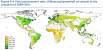
I just realised that the past few days we've been arguing about Theme 3 (agro-climatic POTENTIAL yields), while In my OP I (correctly) made all my low-/high input maps with Theme 4: agro-ecological ATTAINABLE yields. The maps I provided in previous post were thus not in context of my OP, apologies for the confusion. https://gaez.fao.org/pages/theme-details-theme-4
Your skepticism on the entirety of GAEZ is imo misguided, because your skepticism should be directed to specific maps, as every map tells its own story and should be considered in the context it was designed. When trying to compare historical harvested volumes to agro-climatic potential yields, then it won't line up, because the data you compare it to are production volumes (actual yields), not 'potential yields'.
Agro-ecological attainable yields are a step further into the right direction, but even then there are always production gaps between theoretical attainable yields and effectively harvested volumes (actual yields).
The latter is demonstrated in theme 6, and there's a clear higher % achieved in northern regions (like the UK) vs more southern regions (like Spain). What the detailed reasons are for that are something I would need to read up upon, but more reliable conditions in humid England vs drier Spain are probably a major factor. https://gaez.fao.org/pages/data-viewer-theme-6
Returning to fallow periods:
Your numbers on how long fields are fallow in Spain vs England in historic times are no doubt correct, but it does not make sense to compare them to tables where the goal is to illustrate how long fields should remain fallow for soil fertility retention. There are several reasons for a field to be left fallow, and GAEZ does not focus on 'how long it should be fallow due to climate', as you obviously can't grow anything outside of the growing period anyway and it is by default left fallow. Therefore, the focus is on how long it should be fallow for soil fertility retention.
Pretty much all factors you sum of that Simpson noted upon are included in the models. Be it water availablity, pest influence
In conclusion, for global patterns, where specific crop fertilities could be tied to climates, the agro-ecological attainable yield is imo sufficient to estimate ball-park averages. I'm all for adding technological advances to increase these yields, or using the weather front and drought systems to increase/decrease food outputs n the game.
I just realised that the past few days we've been arguing about Theme 3 (agro-climatic POTENTIAL yields), while In my OP I (correctly) made all my low-/high input maps with Theme 4: agro-ecological ATTAINABLE yields. The maps I provided in previous post were thus not in context of my OP, apologies for the confusion. https://gaez.fao.org/pages/theme-details-theme-4
I'm sure the same thing applies to all of the yield maps. They're picking the best time to plant for each location to get the maximum yield. So, winter for Spain and summer for England.
The problem is that the real life situation is more complicated than just comparing the best yield you would get if you did one planting in each place at the optimal time of year.
Returning to fallow periods:
Your numbers on how long fields are fallow in Spain vs England in historic times are no doubt correct, but it does not make sense to compare them to tables where the goal is to illustrate how long fields should remain fallow for soil fertility retention. There are several reasons for a field to be left fallow, and GAEZ does not focus on 'how long it should be fallow due to climate', as you obviously can't grow anything outside of the growing period anyway and it is by default left fallow. Therefore, the focus is on how long it should be fallow for soil fertility retention.
If there is only one fallow number that is used in the calculation and that fallow number does not take into account the practical considerations of only having one season to plant crops or how drier conditions would require more time between plantings, then the fallow number is missing some factors that should be included.
If you read everything that I posted in Simpson, then I find this a shocking thing to type. You think that GAEZ is factoring in the practical benefits of having two seasons of farming versus one (England could divide up the workload), the effect the dry conditions would have on the soil, the lower concentration of livestock and proportionate lower concentration of fertilizer, and the challenges in implementing the Agricultural Revolution techniques that required multiple seasons of rainfall to implement? I mean, I don't think GAEZ is factoring in any of that. If you argued that it includes some of that, I would disagree, but I could at least understand it. All of that? I think it pretty obviously does not include all of that. If you're saying it includes all of that, then I don't think you are being very open-minded. You've decided GAEZ is perfect and nothing I can say will change your mind.
So, to quote the following from my last post:
If you read all of that and say to yourself, "Spain didn't face challenges that made it categorically different from England", then we can just agree to disagree.
It sounds like you are disagreeing with me, which means that you are saying that Spain did not face challenges that made it categorically different. If so, then I think we are in agree to disagree territory. I feel that I have unequivocally proven that agricultural in Spain was categorically different from England. The lower amounts of rainfall and lack of summer rainfall made for a completely different experience with completely different challenges, which should be reflected in much different yields without irrigation.
In conclusion, for global patterns, where specific crop fertilities could be tied to climates, the agro-ecological attainable yield is imo sufficient to estimate ball-park averages. I'm all for adding technological advances to increase these yields, or using the weather front and drought systems to increase/decrease food outputs n the game.
At the end of the day, it isn't up to either of us, so it doesn't really matter. As I said in my last post, if it were me, I would start with the yields from the GAEZ maps, then modify them based on a few factors. Two obvious ones would be 1) summer rainfall (only one planting season creates problems) and 2) concentration of livestock for fertilizer. Spain gets hit for both, so should be significantly lower than England without irrigation.
Let me conclude with why I am arguing this point. It may be that we are not that far apart when the why is taken into consideration.
If I am playing as Spain, then I want the dry conditions to be a challenge. I want them to be something that I need to overcome. I want to be building expensive irrigation projects to "make the desert bloom". The thing that scares me about your proposal is that the climate wouldn't be a challenge and I wouldn't need to do anything to overcome it. That feels way off to me.
If you agree that the climate should be a challenge, then maybe we are just coming at it in different ways.
I want to start off with this point you made here: I fully agree with your statement: they should behave differently in game.
Imo, I think mediterranean and the semi-arid environments should be hit with droughts that reduce the food output of crops, unless there's a river or irrigation present. The inverse of how weather fronts work now, and can boost food production in places like England.
If you read all of that and say to yourself, "Spain didn't face challenges that made it categorically different from England", then we can just agree to disagree.
It sounds like you are disagreeing with me, which means that you are saying that Spain did not face challenges that made it categorically different. If so, then I think we are in agree to disagree territory. I feel that I have unequivocally proven that agricultural in Spain was categorically different from England. The lower amounts of rainfall and lack of summer rainfall made for a completely different experience with completely different challenges, which should be reflected in much different yields without irrigation.
You have indeed absolutely proven Spain was different than England. I do not try to argue with that.
What I AM arguing for is that the GAEZ data is also correct, but needs to be interpreted in the context the data was made for. It is not a direct comparison tool of effective yields across the globe, but a model of what is attainable given certain levels of input.
Whether a region can feasibly achieve these levels of input, is another matter entirely. Spain evidently has always struggled with these inputs, with even varying degrees within the country in itself, as you have indeed demonstrated.
BUT this does not mean the GAEZ model is incorrect, the model does not try to emulate this either.
Let me rephrase what I'm defending and arguing for:
I'm not disagreeing that actual yields across Spain were even remotely equivalent to England, quite the contrary, as the GAEZ maps of attainable yields also illustrate this. I'm not arguing about any of this at all.
I'm not dictating that the GAEZ is holy, I'm just not entertained by the idea it's being discredited due to some very specific arguments you have, that make total sense in the context in you are phrasing, but are not applicable to the context the GAEZ is presenting their data. Your consistent arguments that their data 'does not make sense' and that they're making mistakes, is that you're interpreting their maps in the wrong context which you use as basis to disregard them. I just want to defend the GAEZ data, that they absolutely have their merit, and that they provide the best basis we have to determine the 'natural potential' a region has, regardless of what resources humans can throw at it. Be it historical or modern.
the agro-ecological atttainable yield, focuses on ONLY these agro-ecological factors. Not technologies, not availablility of livestocks. It presents a global model for what each region can yield given a certain amount of input, equalised for the entire world. Whether or not you actually have 20 cows: if you WOULD have 20 cows, this is what you could attain. Yes summer droughts are severe in Southern Spain, but are offset by the fact that the growing period can realistically be extended earlier into spring and later into autumn. Is that the actual practice in real life? Not historically at least, as you pointed out, but this map is not trying to illustrate that either. These maps are not 'wrong', but they can be interpreted in the wrong context.
I'm sure the same thing applies to all of the yield maps. They're picking the best time to plant for each location to get the maximum yield. So, winter for Spain and summer for England.
The problem is that the real life situation is more complicated than just comparing the best yield you would get if you did one planting in each place at the optimal time of year.
Yes, that's what the potential map is all about.
Have you looked at any of the maps I've been posting in the meantime? Attainable yields for Spain are significantly lower, with some local exceptions, and in large parts of the country attainable yields are even abysmal.
The "real life situation" you are interested in are actual yields. Not attainable yields, not potential yields. I'm just advocating to not compare apples with pears and bananas: the agro-climatic map dictates what the climate is theoretically capable of, when optimising for the conditions of said climate. Whether or not those optimisations are feasible or easily reached is another matter entirely.
This is why I made the three separate maps in the first place:
- agro-climatic potential yields map, says you even have (low) potential yields for growing sturdy grains in the middle of the Sahara. Obviously the actual window of doing this is guaranteed unlikely to achieve this in real life.
- agro-ecological attainable yields map - low input, is when you do low efforts by modern standards - this is probably what Spain was able to procure in historic times, ball-park wise.
- agro-ecological attainable yields map - high input is when you optimise fertilisation and labor - England was probably a whole lot more leaning towards this end of the spectrum, due to the factors you mentioned earlier (livestock, fertilizer, more practical seasons).
If there is only one fallow number that is used in the calculation and that fallow number does not take into account the practical considerations of only having one season to plant crops or how drier conditions would require more time between plantings, then the fallow number is missing some factors that should be included.
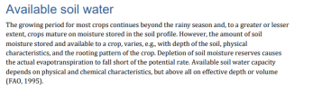
Growing period accounts for the precipitation patterns and thermal regimes, and fallow accounts for the soil fertility recharge. We can argue semantics all day, but water access etc. is all accounted for in their model. I really don't see the problem: you consider the effects of the dry climate issue in that land has to be left fallow. You therefore argue that this must be used in the equations. GAEZ uses the raw climate data directly: soil moisture, precipitation, thermal regimes,... dictate the potential growing period and therefore the potential biomass that can be grown. However, without fertilisers, you're still forced to fallow fields due to soil fertility recharge. Thát is what they're using as a factor.
Of course, all of this resulted in different agricultural practices around the world, two-field, vs three-field systems, the eventual usage of the four-field system etc. But depending on your inputs (low in spain, higher in England), what is attainable will differ. But if you consider similar inputs around the globe (low inputs or high), you get the GAEZ maps. And thát's their goal: to emulate what nations and regions can strive towards.
If you read everything that I posted in Simpson, then I find this a shocking thing to type. You think that GAEZ is factoring in the practical benefits of having two seasons of farming versus one (England could divide up the workload), the effect the dry conditions would have on the soil, the lower concentration of livestock and proportionate lower concentration of fertilizer, and the challenges in implementing the Agricultural Revolution techniques that required multiple seasons of rainfall to implement? I mean, I don't think GAEZ is factoring in any of that. If you argued that it includes some of that, I would disagree, but I could at least understand it. All of that? I think it pretty obviously does not include all of that. If you're saying it includes all of that, then I don't think you are being very open-minded. You've decided GAEZ is perfect and nothing I can say will change your mind.
Of course the GAEZ is not perfect, this is modeling we're talking about, it will never be perfect.
it defines growing seasons as a whole, capturing which technologies are/were being used in a specific location are not the goal of these maps
dry/wet conditions of the soil are absolutely calculated, what makes you think it isn't?
Available soil water
The growing period for most crops continues beyond the rainy season and, to a greater or lesser extent, crops mature on moisture stored in the soil profile. However, the amount of soil moisture stored and available to a crop, varies, e.g., with depth of the soil, physical characteristics, and the rooting pattern of the crop. Depletion of soil moisture reserves causes the actual evapotranspiration to fall short of the potential rate. Available soil water capacity depends on physical and chemical characteristics, but above all on effective depth or volume(FAO, 1995).
livestock and fertility is emulated through the 'low inputs' vs 'high inputs' factors. Indeed, if England has more cattle, more fertilizers than Spain, it will have results more akin to the 'high input' map mode, and Spain more towards 'Low input'. This doesn't make either map mode wrong in what it's trying to portray.
Technological advances are also included in the 'inputs' map (with a modern twist as in: use of motorized vehicles, etc.). Again within one map, all regions are treated equally in terms of what is potentially being used. Rural England is capable of far higher inputs than the majority of Rural Spain, even in modern day.
---
To summarise:
I agree Spain had (and has) lower outputs than England, and that it indeed in game should emerge that way.
BUT, these are ALSO (not only) the result of practical, logistical and technological limitations that prevent successful adaptation to the local agro-climatic conditions, rather than purely climate in and of itself. The GAEZ maps demonstrate what is attainable for each agro-ecological region, given a certain amount of input.
But which input levels are actually being reached in practice, is another matter entirely. and thát's why I'm arguing that the models of the GAEZ are not wrong, and one should just be careful how to interret and apply them.
I want to start off with this point you made here: I fully agree with your statement: they should behave differently in game.
Imo, I think mediterranean and the semi-arid environments should be hit with droughts that reduce the food output of crops, unless there's a river or irrigation present. The inverse of how weather fronts work now, and can boost food production in places like England.
You have indeed absolutely proven Spain was different than England. I do not try to argue with that.
What I AM arguing for is that the GAEZ data is also correct, but needs to be interpreted in the context the data was made for. It is not a direct comparison tool of effective yields across the globe, but a model of what is attainable given certain levels of input.
Whether a region can feasibly achieve these levels of input, is another matter entirely. Spain evidently has always struggled with these inputs, with even varying degrees within the country in itself, as you have indeed demonstrated.
BUT this does not mean the GAEZ model is incorrect, the model does not try to emulate this either.
Let me rephrase what I'm defending and arguing for:
I'm not disagreeing that actual yields across Spain were even remotely equivalent to England, quite the contrary, as the GAEZ maps of attainable yields also illustrate this. I'm not arguing about any of this at all.
I'm not dictating that the GAEZ is holy, I'm just not entertained by the idea it's being discredited due to some very specific arguments you have, that make total sense in the context in you are phrasing, but are not applicable to the context the GAEZ is presenting their data. Your consistent arguments that their data 'does not make sense' and that they're making mistakes, is that you're interpreting their maps in the wrong context which you use as basis to disregard them. I just want to defend the GAEZ data, that they absolutely have their merit, and that they provide the best basis we have to determine the 'natural potential' a region has, regardless of what resources humans can throw at it. Be it historical or modern.
the agro-ecological atttainable yield, focuses on ONLY these agro-ecological factors. Not technologies, not availablility of livestocks. It presents a global model for what each region can yield given a certain amount of input, equalised for the entire world. Whether or not you actually have 20 cows: if you WOULD have 20 cows, this is what you could attain. Yes summer droughts are severe in Southern Spain, but are offset by the fact that the growing period can realistically be extended earlier into spring and later into autumn. Is that the actual practice in real life? Not historically at least, as you pointed out, but this map is not trying to illustrate that either. These maps are not 'wrong', but they can be interpreted in the wrong context.
Yes, that's what the potential map is all about.
Have you looked at any of the maps I've been posting in the meantime? Attainable yields for Spain are significantly lower, with some local exceptions, and in large parts of the country attainable yields are even abysmal.
The "real life situation" you are interested in are actual yields. Not attainable yields, not potential yields. I'm just advocating to not compare apples with pears and bananas: the agro-climatic map dictates what the climate is theoretically capable of, when optimising for the conditions of said climate. Whether or not those optimisations are feasible or easily reached is another matter entirely.
This is why I made the three separate maps in the first place:
- agro-climatic potential yields map, says you even have (low) potential yields for growing sturdy grains in the middle of the Sahara. Obviously the actual window of doing this is guaranteed unlikely to achieve this in real life.
- agro-ecological attainable yields map - low input, is when you do low efforts by modern standards - this is probably what Spain was able to procure in historic times, ball-park wise.
- agro-ecological attainable yields map - high input is when you optimise fertilisation and labor - England was probably a whole lot more leaning towards this end of the spectrum, due to the factors you mentioned earlier (livestock, fertilizer, more practical seasons).
Growing period accounts for the precipitation patterns and thermal regimes, and fallow accounts for the soil fertility recharge. We can argue semantics all day, but water access etc. is all accounted for in their model. I really don't see the problem: you consider the effects of the dry climate issue in that land has to be left fallow. You therefore argue that this must be used in the equations. GAEZ uses the raw climate data directly: soil moisture, precipitation, thermal regimes,... dictate the potential growing period and therefore the potential biomass that can be grown. However, without fertilisers, you're still forced to fallow fields due to soil fertility recharge. Thát is what they're using as a factor.
Of course, all of this resulted in different agricultural practices around the world, two-field, vs three-field systems, the eventual usage of the four-field system etc. But depending on your inputs (low in spain, higher in England), what is attainable will differ. But if you consider similar inputs around the globe (low inputs or high), you get the GAEZ maps. And thát's their goal: to emulate what nations and regions can strive towards.
Of course the GAEZ is not perfect, this is modeling we're talking about, it will never be perfect.
it defines growing seasons as a whole, capturing which technologies are/were being used in a specific location are not the goal of these maps
dry/wet conditions of the soil are absolutely calculated, what makes you think it isn't?
livestock and fertility is emulated through the 'low inputs' vs 'high inputs' factors. Indeed, if England has more cattle, more fertilizers than Spain, it will have results more akin to the 'high input' map mode, and Spain more towards 'Low input'. This doesn't make either map mode wrong in what it's trying to portray.
Technological advances are also included in the 'inputs' map (with a modern twist as in: use of motorized vehicles, etc.). Again within one map, all regions are treated equally in terms of what is potentially being used. Rural England is capable of far higher inputs than the majority of Rural Spain, even in modern day.
---
To summarise:
I agree Spain had (and has) lower outputs than England, and that it indeed in game should emerge that way.
BUT, these are ALSO (not only) the result of practical, logistical and technological limitations that prevent successful adaptation to the local agro-climatic conditions, rather than purely climate in and of itself. The GAEZ maps demonstrate what is attainable for each agro-ecological region, given a certain amount of input.
But which input levels are actually being reached in practice, is another matter entirely. and thát's why I'm arguing that the models of the GAEZ are not wrong, and one should just be careful how to interret and apply them.
Thank you for writing this. I know it took more time, but it really, really helped. It went into a lot more depth and gave examples, which was what I needed to understand your position.
The short version is that you've largely convinced me.
The long version is a bit more complicated.
First, when I read the above, I understood what you were saying. GAEZ takes all of the factors that were raised by Simpson into consideration. If a farmer in England or Spain uses the methods that GAEZ is based upon (modern methods), then they would expect to achieve the GAEZ yields. GAEZ modelers are aware of dry conditions drying out the soil, etc. BUT, that doesn't mean that historic farmers would achieve those yields. That's because historic farmers might use different methods than GAEZ was based on. However, a time-traveler from today going back to historic Spain/England using the GAEZ methods would achieve the GAEZ results.
That makes sense to me.
But that does create a problem. The point of these maps is not to model what a time-traveler would achieve going back in time using modern methods, but to model what the historic farmer would have achieved using historic methods. While you could just assign modern yields to the historic farmer, which is effectively what you are proposing, there is an assumption in doing so:
The difference in yields for modern methods and historic methods is the same between places. That might not be the case. England was doing simpler farming than was done in Spain. As Simpson makes clear, dry-farming was more technically difficult than traditional farming. Modern dry-farming methods might have advanced more than traditional farming methods, which would make it so that Spain would benefit more by applying modern yields than England. For example, modern methods have probably come up with a better solution to the dry climate than fallowing 50% of the time.
That said, your response should be: "It's the best we can do". I get that. I'm just pointing it out.
My issue with the maps is that the low-input attainable map for Spain looks relatively close to England. If you exclude the mountainous areas in Spain, then the yields in the populated parts of Spain look pretty similar to most of southern England. For example, the plateau areas look pretty similar to southern parts of England excluding East Anglia and the London area.
That could be explained by Spain gaining more by using modern yields. I'm not sure what we do about it, but I'm just pointing it out. The impression Simpson gives is that dry farming was pretty hard and that yields in Spain should be a fair bit worse than England. That doesn't appear to be the case based on the low-input attainable yield map to me.
That said, you did propose making droughts more common in dry climate locations, which maybe solves the issue. While the yields might not be that bad, the penalty would be that they are inconsistent.
Moving on, one thing that I found very encouraging is that I went into GAEZ and the difference between the high-input and the low-input yields was roughly triple (not sure I had all of the same map selections, but hopefully that is true for your maps as well). IF Spain and England had the same yields at the start and Spain stayed at low-input while England went to high-input, then England would have roughly triple Spanish yields at the end. If it's a lot harder for Spain to achieve high-input than England, then that would make sense to achieve the historic situation.
That made a big difference in convincing me.
So, presently, I'm largely convinced. The low-input maps might be generous for the dry climates, but that can be offset by making droughts more common. The end game difference can be achieved by making it difficult for Spain (or other dry-location country) to upgrade to high-inputs. It all seems to fit together pretty well. Not that convincing one forum member is worth a lot, but congrats. I wasn't easy to convince. I think you've proposed something sensible and defended it well.
Thank you for writing this. I know it took more time, but it really, really helped. It went into a lot more depth and gave examples, which was what I needed to understand your position.
Your position was also very clear, and I learnt a lotfrom it in the process, too.
I really enjoy these discussions with you, they're always well supported, well cited, well written and very respectful.
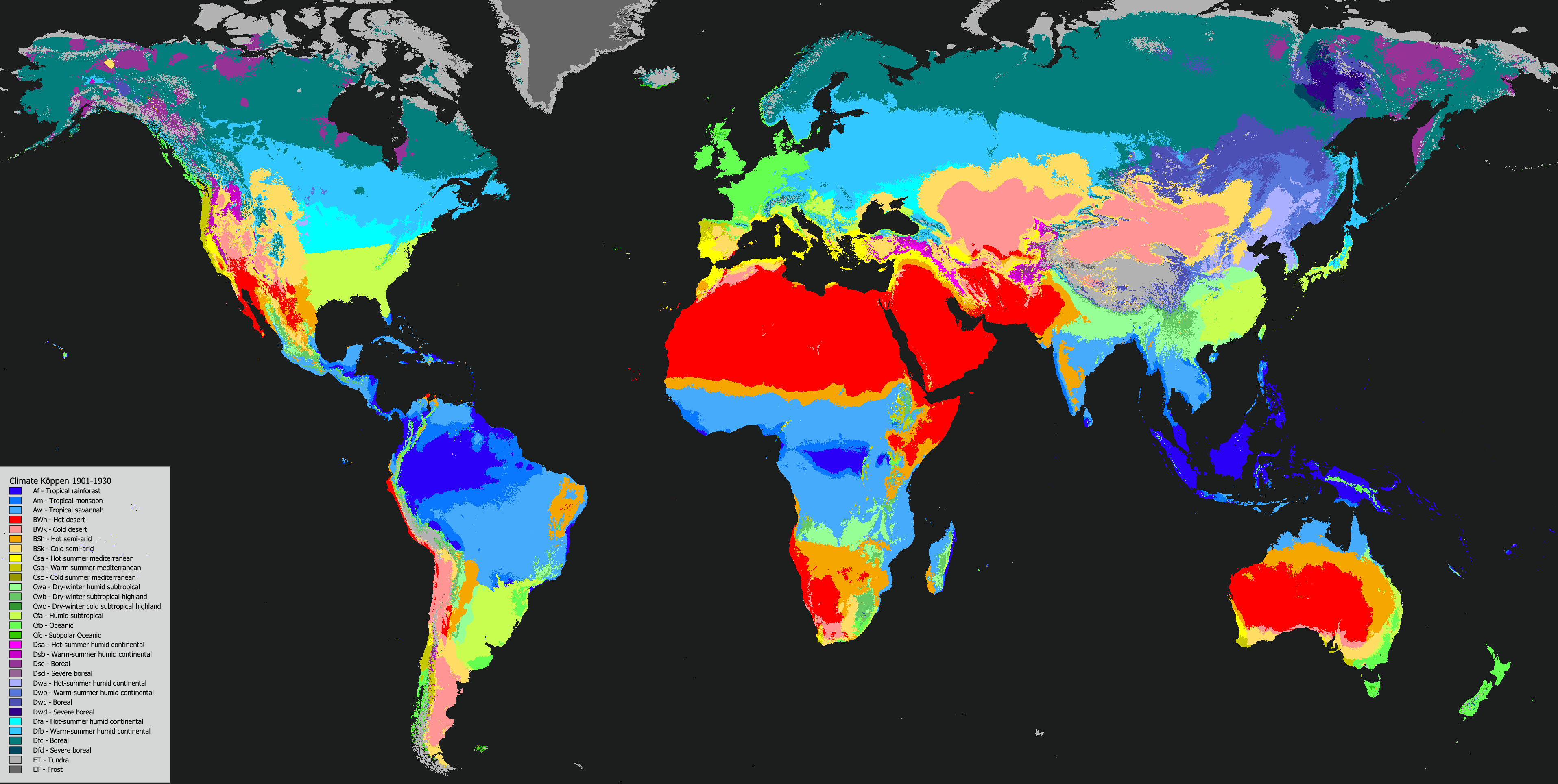
When you map Köppen climate classifications to the EUV categories, @Sulphurologist you map boreal climates with no dry season (Dfc) to arctic but map boreal climates with a summer or winter dry season (Dsc or Dwc) to continental. The developers admittedly seem to be a bit inconsistent themselves, particularly with Dwc, but having Dsc be continental means there is a decent amount of continental quite far up in the Arctic.
When you map Köppen climate classifications to the EUV categories, @Sulphurologist you map boreal climates with no dry season (Dfc) to arctic but map boreal climates with a summer or winter dry season (Dsc or Dwc) to continental. The developers admittedly seem to be a bit inconsistent themselves, particularly with Dwc, but having Dsc be continental means there is a decent amount of continental quite far up in the Arctic.
IIRC I matched the Koppen categories to the extents of how Tinto seemingly mapped them. Unless I made a mistake, Tinto indeed maps Dfc to Arctic, and Dsc, Dwc to Continental.
I think they actually weren't consistent with Dwc for instance (looking at Eastern Siberia, where it's arctic)
note: climate map here is pre-update to 1901-1930
Also, thanks to your post I finally got the courage to fix the mistake with the high-inputs potatoes map and statistics. The OP and the google sheets have been updated.