We have updated our Community Code of Conduct. Please read through the new rules for the forum that are an integral part of Paradox Interactive’s User Agreement.
You are using an out of date browser. It may not display this or other websites correctly. You should upgrade or use an alternative browser.
Whether they made wine in Scandinavia is interesting for Scandinavian history or the long term view of global warming, but it's pretty much irrelevant to the question of how they got to name Vinland.
Not irrelevant to the question that was asked by @Acheron , who clearly asked "Did the Vikings make wine?"
Perhaps some kindness to those who are asking questions might be extended by those who have all of the answers?
And hasn't the reason for the name Vinland already been clearly established in this thread multiple times (including various posts from @rakovskii )?
Sometimes it's hard to tell people's tones in internet discussions because they are just tuping sentences, so you don't get aids like voice tones and face expressions, unless they use emojis like So sometimes to make upf or it, I try to hit Like on everyone's helpful answers, like in this thread.
The story really is a cool mystery, in part because it's neat for me, living in the US, to think that the Vikings visited or camped in the US. But it's also pretty tricky to figure out. @Wagonlitz was doing a good job pickin gover the text, but I guess he got burnout.
My guess is that Hop (Tidal Pool Estuary) Land is in New England and Straumsfjord is in the Bay of Fundy, because of its strong currents, but it's not clear. A lot of this information in the two Sagas is not specific enough to a specific location.
For instance, the Amerindians attack at Hop with skin canoes, and it seems that B. Wallace is right that Amerindians only had skin canoes from the region of central Maine northward, and that we would be talking about the Micmacs with skin canoes or other such tribes with them. However, the author of the Saga could be misremembering the type of canoes that the Amerindians had at Hop.
Yet the Saga of Eric the Red also says that Hop had a snowless winter, whereas the winter today in Rhode Island is a couple degrees below freezing, so that it seems that we would more likely be talking about a spot in Rhode Island, or a place further south. Literally, the Carolinas from the costal south of NC southward do not get snow many years. But the snowless winters might not be meant literally.
Or to give another piece of evidence, Rhode Island has such big literal tidal pool estuaries, that RI might be called "Hop" reasonably well, yet lots of other places on the Atlantic coast also have tidal pool estuaries.
In Chapter 14 of Sephton's 1880 translation of Eric the Red's Saga, the Vikings go to Kjalarnes (north or northeast Cape Breton or the north end of Newfoundland) and then sail a long time west with the land on their west side to a westward flowing river in the one-footer's mountainous area. The author supposes that the mountain range here connects to Hop. The Gaspe' Peninsula has a lot of westward flowing rivers, and it's mountainous, and its mountain range runs south to New England. But the Saga's comment about the mountain connecting to Hop is only in the Hauksbok version of the Saga, not the Skalholtsbok version of the Saga.
Technically, there are also other westward flowing rivers, like on the western coasts of Nova Scotia and Newfoundland. But those are really more southwestward-running coasts, whereas the Saga says that the Vikings sailed west a long time (instead of a specified number of days) to get to the one-footer's mountain region. Nova Scotia's west coast with westward flowing rivers is really only like 70 miles long, which would not really be long for the VIkings. Newfoundland's west coast is like 250-300 miles long, so it's more within the expected range for a "long" travel, considering that the Vikings might make 84 miles in 12 hours at 7 mph. In contrast, a coastal journey to the Gaspe' Peninsula's westward rivers from the north of Cape Breton could cover 500 miles.
The one-foot in the story I guess is the Atlatl. The Micmacs used an Atlatl weapon, and I don't know if the Beothuks also used Atlatls, but some Arctic peoples did.
There are a bunch of other pieces of evidence like the four ones above about where Hop would be. But they don't really prove that Hop was in New England, or really any other specific place. I suppose that you have to consider it to be someplace more than two estuaries at least southeast of L'anse aux Meadows down Newfoundland's northeast coastline.
For me, it seemed odd that a people would name a land after something they ought to have hardly known. However, the thing about communion wine especially is relevant. My wild guess would be now, that wine was rare and exotic to the Vikings but also a luxury good, something they cared about, so finding a land where there seemed to grow grapes for wine, they named it wineland.
I'd suspect that discovering a big island was a big deal so most people Is suspect would be unlikely to name it after whatever they had for breakfast. More likely, name it after something in abundance there (Iceland) or maybe, if you are an early adopter of marketing, after something you want people to believe is in abundance there (hello Greenland).
And now, I wonder if more Scandinavians might have settled in the new world if they hadn't been burned by not-so-Greenland.
For me, it seemed odd that a people would name a land after something they ought to have hardly known. However, the thing about communion wine especially is relevant. My wild guess would be now, that wine was rare and exotic to the Vikings but also a luxury good, something they cared about, so finding a land where there seemed to grow grapes for wine, they named it wineland.
Right. There's a bunch of arguments that the Vikings knew what grapes were. Another was that in the Greenlanders' Saga, there is a German named Tyrker with the Vikings who finds the grapes in Vinland and gets drunk off them, They ask him if those are really grapes, and he answers Yes, he can tell, because his homeland has grapes.
It's kind of funny geographically that the southern half of the St Lawrence Gulf has grapes but Denmark barely does, since I think of them as comparably cold. But actually the reason for this is due in part to the issue of latitude, whereby the grapes grow across the globe usually based on latittudes. Similarly, most of Newfoundland is actually south of Ireland, but my connotations in my head are that Newfoundland is colder than Ireland.
The grapes come up in a couple more ways with the Vinland identification issue. There's a bunch of early modern sources specifying that Newfoundland had grapes in its west and east regions in the early modern period. And there are grapes cultivated there now. But grapes don't grow wildly in Newfoundland's range today. One would expect that there would be more grapes growing wild in New Brunswick than in Newfoundland 1000 years ago. So you can really look at this issue a couple ways as to the likelihood that the Vikings would have found grapes in Newfoundland and named it Vinland or if they would have traveled to New Brunswick to find the grapes. It doesn't look dispositive of the issue.
The Saga overall gives the impression that the main problem for the Vikings in settling Vinland was conflict with the Amerindians. This is specifically why they say that they left the land of Hop, and they note that it was quite a good place in terms of fertility and arability.
Climate must have played a role to some extent. The Greenlanders 1000 years ago grazed cattle, and the Sagas talk about them bringing their cattle to the Americas. So this shows that at that time, they weren't well adapted to very cold temperatures like in Newfoundland or Greenland. If they had been very well adapted, they would have fared better in Greenland like the Eskimos did. They did adapt better over time and switched from cattle to sheep herding, but it still wasn't as good as the Eskimos did.
Then some other factors are the scarcirty of wood on Greenland north of their Eastern Settlement at the south end of Greenland, and the logistical great distance from their bases in Norway and Iceland. They can't easily send supply, colonial, or army expeditions from Norway to the St. Lawrence Gulf area and Newfoundland. 500 years later, the Spaniards did this pretty well, but they were dealing with a warmer climate and more advanced technology than the Vikings had. The Spaniards began by colonizing Caribbean islands, and those regions might have been less threatened by hostile Amerindians than the eastern St. Lawrence Gulf was.
In the Amerindians' defense, neither the Vikings nor the Spaniards nor the 16th-17th century Virginia Colony English colonists treated the Amerindians consistently humanely, and in all 3 cases, the relationship between Europeans and Amerindians had a mix of trade/peace and military conflict. The main Pacifist colony that comes to my mind was the 17th century Quaker colony in PA. Maybe if the Vikings had taken a more pacifistic approach to the Natives, things would have turned out better. Based on information on Viking raids in Western Europe, the Vikings had an aggressive tradition. Eric the Red in the Greenlanders' Saga got exiled from Iceland for manslaughter. The Vikings did trade with the Amerindians, so it looks like they had a mixed relationship.
Not irrelevant to the question that was asked by @Acheron , who clearly asked "Did the Vikings make wine?"
Perhaps some kindness to those who are asking questions might be extended by those who have all of the answers?
And hasn't the reason for the name Vinland already been clearly established in this thread multiple times (including various posts from @rakovskii )?
I didn't intend to sound harsh, I'm sorry if it came across that way. But I do stand by the content, the name makes sense even if the Norse were familiar with wine without making it in their homeland.
Right. There's a bunch of arguments that the Vikings knew what grapes were. Another was that in the Greenlanders' Saga, there is a German named Tyrker with the Vikings who finds the grapes in Vinland and gets drunk off them, They ask him if those are really grapes, and he answers Yes, he can tell, because his homeland has grapes.
It's kind of funny geographically that the southern half of the St Lawrence Gulf has grapes but Denmark barely does, since I think of them as comparably cold. But actually the reason for this is due in part to the issue of latitude, whereby the grapes grow across the globe usually based on latittudes. Similarly, most of Newfoundland is actually south of Ireland, but my connotations in my head are that Newfoundland is colder than Ireland.
The grapes come up in a couple more ways with the Vinland identification issue. There's a bunch of early modern sources specifying that Newfoundland had grapes in its west and east regions in the early modern period. And there are grapes cultivated there now. But grapes don't grow wildly in Newfoundland's range today. One would expect that there would be more grapes growing wild in New Brunswick than in Newfoundland 1000 years ago. So you can really look at this issue a couple ways as to the likelihood that the Vikings would have found grapes in Newfoundland and named it Vinland or if they would have traveled to New Brunswick to find the grapes. It doesn't look dispositive of the issue.
The Saga overall gives the impression that the main problem for the Vikings in settling Vinland was conflict with the Amerindians. This is specifically why they say that they left the land of Hop, and they note that it was quite a good place in terms of fertility and arability.
Climate must have played a role to some extent. The Greenlanders 1000 years ago grazed cattle, and the Sagas talk about them bringing their cattle to the Americas. So this shows that at that time, they weren't well adapted to very cold temperatures like in Newfoundland or Greenland. If they had been very well adapted, they would have fared better in Greenland like the Eskimos did. They did adapt better over time and switched from cattle to sheep herding, but it still wasn't as good as the Eskimos did.
Then some other factors are the scarcirty of wood on Greenland north of their Eastern Settlement at the south end of Greenland, and the logistical great distance from their bases in Norway and Iceland. They can't easily send supply, colonial, or army expeditions from Norway to the St. Lawrence Gulf area and Newfoundland. 500 years later, the Spaniards did this pretty well, but they were dealing with a warmer climate and more advanced technology than the Vikings had. The Spaniards began by colonizing Caribbean islands, and those regions might have been less threatened by hostile Amerindians than the eastern St. Lawrence Gulf was.
In the Amerindians' defense, neither the Vikings nor the Spaniards nor the 16th-17th century Virginia Colony English colonists treated the Amerindians consistently humanely, and in all 3 cases, the relationship between Europeans and Amerindians had a mix of trade/peace and military conflict. The main Pacifist colony that comes to my mind was the 17th century Quaker colony in PA. Maybe if the Vikings had taken a more pacifistic approach to the Natives, things would have turned out better. Based on information on Viking raids in Western Europe, the Vikings had an aggressive tradition. Eric the Red in the Greenlanders' Saga got exiled from Iceland for manslaughter. The Vikings did trade with the Amerindians, so it looks like they had a mixed relationship.
IMO the most important factor is the population from which the prospective settlers would come. Keep in mind that Iceland was relatively thinly populated at this time and that Greenland, in turn drawing on Icelandic settlers, was a small colony. Neither place had enough surplus population to build a sizeable settlement in Vinland without affecting their welfare, or in Greenland's case even risking its survival. If the new colony had been able to draw directly on Norway, things could have been different but, as it was, we're talking a small group in Greenland deciding whether they could split into two. That's a difficult decision just based on the climate and the basic economy of a settlement; it becomes impossible when you take into account the risk of losing people, or for that matter cattle, to native raids.
Compare it to a 4X game where you have a 1 pop city with a nice bit of land further on. You can't do it from that city until it grows but it's on tundra and barely survives. The next one over is pop 2 or 3, it could be done but would set that city back by tens of turns. If you played Civilization and you had Norway, you'd ideally recruit the settler there and sail it all the way over. In real history, though, the Norse didn't play as a unitary civilization: links were tenuous, news spread slowly and various political and economic troubles got in the way.
I didn't intend to sound harsh, I'm sorry if it came across that way. But I do stand by the content, the name makes sense even if the Norse were familiar with wine without making it in their homeland.
IMO the most important factor is the population from which the prospective settlers would come. Keep in mind that Iceland was relatively thinly populated at this time and that Greenland, in turn drawing on Icelandic settlers, was a small colony. Neither place had enough surplus population to build a sizeable settlement in Vinland without affecting their welfare, or in Greenland's case even risking its survival. If the new colony had been able to draw directly on Norway, things could have been different but, as it was, we're talking a small group in Greenland deciding whether they could split into two. That's a difficult decision just based on the climate and the basic economy of a settlement; it becomes impossible when you take into account the risk of losing people, or for that matter cattle, to native raids.
Compare it to a 4X game where you have a 1 pop city with a nice bit of land further on. You can't do it from that city until it grows but it's on tundra and barely survives. The next one over is pop 2 or 3, it could be done but would set that city back by tens of turns. If you played Civilization and you had Norway, you'd ideally recruit the settler there and sail it all the way over. In real history, though, the Norse didn't play as a unitary civilization: links were tenuous, news spread slowly and various political and economic troubles got in the way.
You're right, but settling Vinland would not have been as bad as you make it sound. If the Norse needed to settle Vinland, they realistically could have done that.
By comparison, for the Spaniards, there was a religious compulsion to spread Christianity across the globe, although it was not as much of a motivation for them as a route to the Indies and gold mining was the Spanriards' motivation. The Vikings were into Christianity, but it was still a new thing for them and in c. 1000 AD, only about half of them on the Vinland trips were Christian according to the Sagas. When the Vinland Sagas talk about the drive to spread Christianity to Greenland, it's like they are talking about spreading it to the Vikings living there.
You gave the analogy about a 4x game where they would have to settle a 1 Pop Tundra colony, but in real life, the Vikings didn't need to acquire the connecting lands between Greenland and Vinland, such as Baffin Island and Labrador. Rather, they theoretically just needed to carry a ship with settlers to Newfoundland or Vinland in order to start a colony in real life, and the ship could most reliably hug landmasses like Labrador to get there. In the game IMPERATOR, to colonize a lot of lands across seas, you don't even need to control lands on the most direct land-sea route.
It sounds like the Amerindians were the toughest factor. Befriending the natives would be a realistic possibility, but it could be a little tricky to find from an initial exploration which tribes were the most peaceful. The Vikings' MO seems to have been, including in Western Europe, some mix of random raids, political domination, settlement, conquest, building Viking-style basic forts/castles in strategic spots near target cities, etc. Look at how the Vikings subjugated parts of England, Scotland, Ireland, the Orkneys, and Shetlands. It's not complicated when it comes to settling the Orkneys, Shetlands, and Iceland, because there are almost no other people there (some Irish maybe), it's close to Norway, has decent summers and forests, etc.
Labrador, Greenland, Baffin Islands - these are for settling if you are well adapted like the Eskimos and Dorset people have been. It's impressive how far north Eskimo settlements are in Greenland, Baffin Island, Alaska, etc. The Vikings would have had to have adapted and practically lived off the land like the Eskimos did, probably befriending them, learning from them. This was not the kind of "one with nature" approach that the Vikigns took, at least not to that extent.
Farther south in the new world, the Vikings' Modus operandi had a big risk of backfiring on them, because if they raid some Indian villages like how they raided the British Isles' monasteries, the Indians are native there and have big numbers to fight back. If the Indians perceive the Vikings as threats, it's a big problem for the Vikings, because unlike in Britain, the Vikings don't have the numbers and accessibility and impulse/drive to keep sending successive waves of conquerors and raiders into North America's arable lands south of Labrador. Britain, Colombia, Holland, and Mexico had treasure for the Vikings to raid, but Vinland did not. Vinland had grapes and butternuts and arable land, but that's really not as lucrative for one-time expeditions. There is a kind of psychological/sociological phenomenon, whereby being a raider/aggressor "works" in the short term, like robbing someone's pocket money or scamming customers, but it's a self-destructive policy in the long term.
The Amerindians of Newfoundland and farther south, ie. the Algonquin tribes weren't cannibals, so it's not really as if living in harmony with them was unfeasible. The French sent missionaries to live with them in the 16th century, and the missionaries did OK, taught the Indians writing and had some success with Christianizing them. In the Norse stories about Ireland the Great west across the ocean from Ireland, some Norse persons went to Ireland the Great at different times and lived among the Amerindians there.
But this would require a different MO than the Vikings used. In Eric the Red's Saga, the Vikings send a colonizing expedition of like 160 people and three ships with cattle to the lands south of Labrador. Out of these 160 people, suppose that a big majority of them were peaceful and super respectful to the Amerindians. It would still just take a few vikings to "Go Viking" in the literal Old Norse meaning of the word and kill some Natives in order for relations to go south. SInce they didn't understand each other's languages, there's a lot more room for misunderstanding. They could have gotten a Sacagawea-type Native guide and helper, and maybe historically they did, but this would be a different approach, like the Lewis and Clarke expedition strategy.
I meant that Greenland was the 1 pop colony on tundra. Not that they needed to settle anything in between but rather that Greenland itself did not have the population. Remember, it's only a single generation since it was itself settled from Iceland. The legend says 14 ships made it to shore then, which allows a rough estimate of ca. 500 people. The ships would have been the ocean-going kind, presumably knarrs (or whatever the plural of knarr is) which usually had a crew of 20 to 30. You could stow more people aboard but the ships also had to carry livestock and provisions for the first months. New colonies rarely thrive right from the start, the first few years are usually difficult and more about survival than growth. All the more so in the conditions of the Greenland colony. Even at its height, its estimated population was between 2000 and 10,000 people, with most historians on the lower end (according to Wikipedia), and that's much later. In the first generation it's probably close to the number of original settlers.
So those 160 people in Eric the Red's Saga represent about 25% of Greenland's population. That's a huge percentage, so high that I rather suspect the saga is off. I don't know if the original text says all 160 were in the same 3 boats with the cattle, or that there were more ships but 3 specifically carried cattle; maybe @Wagonlitz can clarify? In any case, it doesn't change much if we do take these figures for the settling of Greenland, it raises the total number to 14 x 50 or ca. 700 people. 160 would still be about 20% of Greenland's population.
You can imagine the trouble it causes to the still young settlement in Greenland when 20% of its population leaves. Then imagine what happens if the settlement of those 160 people in Vinland gets in trouble: where do they get reinforcement? They already took everyone Greenland had to spare, any more and Greenland itself could well run into the ground. That's why I suggested they'd have to appeal to Iceland and eventually, because Iceland was also rather thinly populated, all the way back to Norway.
You're right that wars and raids are a big factor here. The losses from peaceful settlement (starvation, poor housing, disease, etc.) are much easier to replace than those plus battle losses. The sagas do suggest that the fight with the skraelings decided the Vinlanders to move back to Greenland. But, first, that's against the background of not having a local surplus population to absorb those losses.
Second, I think you shouldn't rely too much on the idea of a typical Norse MO. There's a lot more variation between their operations in Francia, Ireland and Russia than you sketch. Iceland, Greenland and Vinland were never about raiding, the first two were practically empty when the Norse found them and they probably thought the same about Vinland initially. The people that wanted to go raiding, stayed in Europe. The ones that went to Iceland wanted to farm or fish or generally live a peaceful life. Although they did take slaves captured on previous raids to Iceland, they didn't expect to continue that practice.
I'm not even sure they thought of Vinland as a new settlement at all. The sagas did later exaggerate the importance of the journey to Vinland (and particularly the role of an ancestor of the person who wrote it down) but that's in hindsight, with the knowledge that the settlement was subsequently lost. The Vinland settlers didn't know that. I think most people on the Vinland expedition didn't regard their new settlement as a separate colony but rather as an extension of Greenland, a place not too far away where they could get some scarce resources such a timber. Think of the relation of a village to a town, it provides something the other villages don't (or not enough anyway), but it doesn't form an economy of its own, it relies on the town for its market and some administrative functions (like a judge or a thing). There are clear signs of this in the sagas, with people sailing back and forth even during the short lifespan of the Vinland settlement. They're not emigrating, then immigrating again, etc. They're more like villagers going to the market town to get something they need. There's no hint of tension between them and the people who stayed in Greenland as you would expect if they were thought of as abandoning the Greenland settlement.
The implication is that on this model, the Vinland settlements would be rather close to Greenland. You don't settle a new village a huge distance away from the town, you want going to market to be fairly easy, To be sure, that's by Norwegian standards, where settlements on its lengthy coast were farther apart than in continental Europe and traffic was often by sea (land traffic in Norway is difficult due to all those mountains). A few days back and forth, a week or two, or even a month, would not be considered unusual in northern Norway, but the smaller settlement would still be oriented towards the bigger one. IMO that makes a northern settlement on Newfoundland more likely than one in the modern USA.
So those 160 people in Eric the Red's Saga represent about 25% of Greenland's population. That's a huge percentage, so high that I rather suspect the saga is off. I don't know if the original text says all 160 were in the same 3 boats with the cattle, or that there were more ships but 3 specifically carried cattle; maybe @Wagonlitz can clarify? In any case, it doesn't change much if we do take these figures for the settling of Greenland, it raises the total number to 14 x 50 or ca. 700 people. 160 would still be about 20% of Greenland's population.
The Saga of Eric the Red says that they had 160 people and that they had ships and cattle with them in these terms:
He went in the ship with Thorvald and his man, because he was widely acquainted with the unpeopled districts. They had the ship which Thorbjorn had brought to Greenland, and they ventured on the expedition with Karlsefni and the others; and most of them in this ship were Greenlanders. There were one hundred and sixty men in their ships.
...
They continued their course up the firth, which they called Straumsfjordr, and carried their cargo ashore from the ships, and there they prepared to stay. They had with them cattle of all kinds, and for themselves they sought out the produce of the land thereabout. There were mountains, and the place was fair to look upon.
I have a little trouble finding out exactly how many ships the Vikings brought on their journey to Straumsfjordr witht he 160 settlers. It was at leat two ships because it talks about the groups of Vikings who arrived there later splitting up into different sailing groups, like how one group got blown to Ireland and another one explored by boat in another direction in the meantime.
Nancy Brown writes on her blog:
In The Saga of Eirik the Red, Karlsefni's expedition had three ships: two crewed by Icelanders, and one, Gudrid's ship, that was "mostly" Greenlanders. Those ten bits of jasper seem to assert Karlsefni's claim.
Which does not push Leif Eiriksson out of the picture. His crew might have wintered here, building themselves a sturdy longhouse and some outbuildings. When Karlsefni and Gudrid arrived four years later, with three ship’s crews to house, perhaps they enlarged the settlement.
You can imagine the trouble it causes to the still young settlement in Greenland when 20% of its population leaves. Then imagine what happens if the settlement of those 160 people in Vinland gets in trouble: where do they get reinforcement? They already took everyone Greenland had to spare, any more and Greenland itself could well run into the ground. That's why I suggested they'd have to appeal to Iceland and eventually, because Iceland was also rather thinly populated, all the way back to Norway. You're right that wars and raids are a big factor here. The losses from peaceful settlement (starvation, poor housing, disease, etc.) are much easier to replace than those plus battle losses. The sagas do suggest that the fight with the skraelings decided the Vinlanders to move back to Greenland. But, first, that's against the background of not having a local surplus population to absorb those losses.
Second, I think you shouldn't rely too much on the idea of a typical Norse MO. There's a lot more variation between their operations in Francia, Ireland and Russia than you sketch. Iceland, Greenland and Vinland were never about raiding, the first two were practically empty when the Norse found them and they probably thought the same about Vinland initially. The people that wanted to go raiding, stayed in Europe. The ones that went to Iceland wanted to farm or fish or generally live a peaceful life. Although they did take slaves captured on previous raids to Iceland, they didn't expect to continue that practice.
I'm not even sure they thought of Vinland as a new settlement at all. The sagas did later exaggerate the importance of the journey to Vinland (and particularly the role of an ancestor of the person who wrote it down) but that's in hindsight, with the knowledge that the settlement was subsequently lost. The Vinland settlers didn't know that. I think most people on the Vinland expedition didn't regard their new settlement as a separate colony but rather as an extension of Greenland, a place not too far away where they could get some scarce resources such a timber. Think of the relation of a village to a town, it provides something the other villages don't (or not enough anyway), but it doesn't form an economy of its own, it relies on the town for its market and some administrative functions (like a judge or a thing).
OK. Your points seem to be that Greenland was a key colony base for settlements in Vinland, so that the Greenland population couldn't afford much to lose many people to a tottering tentative Vinland outlying colony. That makes sense. You are saying that they would have needed to get more people from Iceland and Norway if they wanted to build more colonies and that Iceland also had limited human resources. Right: The limitations of manpower in Greenland and Iceland are a limiting factor. By comparison, the Spaniards made a colony in the coastal south Alabama area and it got devastated by a hurricane in the 16th century. It was one of the first Spanish colonies in the continental US and called Santa Maria de Ochuse (https://www.archaeology.org/news/5791-170807-florida-luna-settlement). So the manpower risks of starting a new colony/outlying village as you say, are a big deal.
So like you said, they would have needed to appeal for more manpower from other Norse communities. With the Spaniards, the Indies route, gold mining like in Puerto RIco, and missionizing were all factors adding to stimulate the Spaniards to colonize the Americas, but we don't have such comparable stimuli that would have made other Norse communities send colonists to Vinland beyond what Iceland could afford. The English found that raiding Spanish treasure ships was lucrative like with Sir Francis Drake, and the Vikings found that European raids were profitable, but Vinland didn't offer the same level of allure for the Vikings at that time.
You seem to differentiate the types of Vikings living in Iceland and further west across the Atlantic from the Norse who attacked Britain. So OK, on one hand there is a difference, like how subugating Ireland with Viking conquests is different than making farms on Iceland and Greenland, etc. We don't find attempts in the Vinland Sagas for the Vikings to vassalize the Inuits or become "kings" of the Skraelings like how the Danes conquered parts of England, the Normans conquered England, or the Varangians became dynastic rulers of Russia. So Yes, there is a difference.
But there is als a similarity of Viking MOs that comes up directly or indirectly in the Sagas, enough to the point that whatever flexible strategy they would need to "go native" and live in harmony with the Natives that vastly outnumbered them in Hop and Vinland was not a typical part of their playbook. So for instance, you write: "The ones that went to Iceland wanted to farm or fish or generally live a peaceful life. Although they did take slaves captured on previous raids to Iceland, they didn't expect to continue that practice." I don't know if you read the Greenlanders' Saga and Eric the Red's Saga where it talks about the settlements south of Vinland. But Yes, this was the kind of stuff that they were doing. The only example of Viking enslavement/kidnapping of Amerindians that sticks out in my head is the case at the end of Eric the Red's Saga where they go against an Amerindian family in Markland/Labrador and abduct the Amerindians' children. They raise the children to speak Norse and the children tell the Vikings about White-Man's-Land as a separate land from Vinland and next to Markland (I guess that this land would be Newfoundland in real life, based on a bunch of descriptions about it in Wikipedia's Ireland the Great entry.). Then there is the story of how the Vikings used Scottish slaves (thralls) to search the Wonder Shores southeast of Kjalarnes. Then there are a bunch of messed up stories of thralls/slaves getting killed in Iceland. And there is the story of a couple Skraelings being found in the sea in medieval times north of Scotland, with one of the modern academic theories being that the Skraelings who were discovered were likely escaped Viking slaves.
Then besides the enslavement issue, there are the cases in both Vinland Sagas where the Vikings just slaughtered a bunch of Amerindians who they found without provocation by the Skraelings/Amerindians. The implication in the Greenlanders' Saga is that the Amerindians came in canoes and attacked the Vikings as payback, and one wounded Viking got buried at Krossanes/Cross-Point.
Starvation, poor housing, and disease don't seem to be critical factors ruining the camps south of Labrador in the Vinland Sagas, although they are a secondary bit of a factor. For instance, there are a few cases of disease, like one major one in Greenland IIRC in one of those Sagas. But the general sense is that the Greenland colony recovered from the outbreak OK eventually. There is information on Iceland and Greenland being relatively better protected from Europe's worst plagues because of how limited they were in contact with mainland Europe.
To get back to the point I was making about the key problem of dealing with Natives, there are at least two strategies that I see. One strategy is the kind of typical Viking strategy that you find in Europe of raiding, subjugation, conquest, mixed with settlement, trading, and farming. I don't want to make too much of a Hagar the Horrible stereotype, but those elements existed, and historically for that matter weren't limited to the Vikings when it came to dealing with Amerindians. This kind of subjugation and domination strategy works OK when you are the 166th century Spaniards and have one of the world's top Armadas, armies of conquistadors, major interest from your home monarch in resource extraction, etc. etc. But when you just are dealing with some tentative settlements, it's a weak policy.
I don't know how familiar you are with the Roanoke Island colony, but they had a skirmish with some natives early on, and one of the colonists seemed to later blame this kind of bad relations on the colony's failure, and IIRC the blame seemed to be on some of the Roanoke colonists' side. In the 17th century, the Dutch colonists in Zwanendaal, Delaware got in a tiff with a local Indian tribe over a piece of art that supposedly one of the Indians stole, and in payback, the Indians wiped out all but one of the Dutch colonists there.
The Vikings called the Amerindians "skraelings," which at least nowadays has a negative connotation, as if they had dry shriveled skin or were weaklings. It just takes a couple Vikings out of 160 on the journey to do something bad to the "Skraelings" for relations to go sour. In one Saga, a bull got loose and charged, and it made relations go bad. I suppose that this might be an allusion to how Vikings used a oxhorn to blow calls and make announcements, but the story that a bull literally got loose and soured relations is also realistic.
The other strategy that the Vikings theoretically could have tried would have been one of living in harmony with the Natives and being very careful about that, with lots of respect being paid to the Natives. It's really not impossible for the Norse to have tried that, based on the story of a Norse exile who came to White-Man's-Land / Ireland the Great west across the ocean from Ireland and lived with the Natives. Based on the available information, the Vikings did have a mixed strategy/tactic collection/practice of trade, settlement, harmonic living, and conflict with the Amerindians in the two Sagas.
You wrote about how a village "relies on the town for its market and some administrative functions (like a judge or a thing)." This is a little bit fun for me to read: What country are you from? The only time I've seen a "thing" referred to in this way is in the Scandinavian context, although that context does apply here.
Firstly: I've skipped most of what's been written since my last post as I just don't have the time for long posts atm, as I've explained in other threads when prodded for a post.
I'm also not sure exactly how much more we can really narrow things down geographically, as the sagas also to some extent are works of fiction - some more than others, and I don't know how much fiction are in the two about Vinland. But even if there's not much fiction, then I'm still not sure we can really narrow it that further down.
But yeah, reason I've not posted until now was plain and simply lack of time for a proper post, plus I just can't easily navigate long posts on my phone and I use the fora on my phone almost exclusively atm.
I've not stopped pondering the topic, though, and have been trying to look at various sources and avenues open to me, including visiting some museums with high quality viking parts. And I have learnt some stuff that might be helpful.
Also, I've tried to investigate what the thing about the Sun being on the sky at dagmål and øgt means, but it seems there's no consensus at all, and that there's a good chance nobody actually knows exactly how the vikings kept time. it's possible that it just is noting that the Sun was on the sky at those times, as opposed to further north where it'd not be visible. Or it could be when it was rising. Thinking about it more myself, based on some talks, etc. as well then I think I myself now slant towards it just meaning it was visible as opposed to further north. Meaning that it'd only be usable for a limit for how far north it could be.
I don't know about the other Norse areas, but in Denmark grapes were grown and wine made at least around Tissø. Albeit, don't know if it was grown and made elsewhre. The national museum mentioned them being grown and made at Tissø, though, so that must have happened. That's also around where you have one of the biggest seats of power in Denmark at teh time, so if it was gonna happen it'd likely be someplace like there.
In any case, it was a high luxury, and growing it also wasn't something you just could do as a farmer, so even in the Danish parts of the Norse area it was a rarity, but did happen. And the vikings from all areas knew about wine in any case.
I'm going to guess that wine from grapes wasn't a normal thing made in Norway, Iceland, or Sweden, and the main homeland for the Vinland explorers was Norway-Iceland. But there was enough contact with Germany and places farther south for them to know about actual grapes.
Wine was a luxury. Normal drinking was (clean) water, beer, and mead. And probably primarily the latter two, if the viking age was similar to the later ages in Scandinavia on that front, as getting clean water was super hard. That's why you in the early modern era had light beer that was almost not alcoholic and which even children drank, and I'd not at all be surprised if you had similar back then, but I don't know.
Iceland doesn'ty actually have an abundance of ice neither now nor back then. Rather it has one area with lots of ice, and that was the area that by chance was reached first and the land was named after that as a result. Had any other part of the land been reached first then it'd have had a different name.
Also, Greenland actually was pretty lush back then, so I'm not sure it was that much of a marketing stunt, and in any case, the theory of peopl emore or less being rused into going to Greenland by promises not holding isn't considered credible anymore.
They weren't burnt by Greenland. In fact Greenland thrived for one reason, and one reason only: Walrus tusks. They were extremely sought after in Scandinavia (and from what I understood Europe in general) and hence it was super profitable to hunt for them.
That's why they did repeated trips north to around Disko, 1000 km north of their settlements, to hunt for walruses for their tusks which were sold to Europe. That's what made Greenland worth colonising. The land wasn't bad, but it also wasn't exceptional, and it's not like there was an outright lack of land elsewhere.
When Europe stopped demanding tusks around the 1300s/1400s that's also when the Greenlandic colony 1) stopped going far north (and hence also likely stopped going to Vinland) and 2) started declining.
The decline seems to not be as much due to the onset of the little ice age as opposed to people plain and simply migrating away as there just wasn't as much money in the area anymore. And when you have a small colony of something like 5-6k people, IIRC, then you don't need that many people to leave before you can't sustain the losses. Similarly, it's known that there were battles with the Inuits, and that the Inuits massacred large amounts of Norse. At the population sizes, then that also starts not being something you really can come back from fast.
So those 160 people in Eric the Red's Saga represent about 25% of Greenland's population. That's a huge percentage, so high that I rather suspect the saga is off. I don't know if the original text says all 160 were in the same 3 boats with the cattle, or that there were more ships but 3 specifically carried cattle; maybe @Wagonlitz can clarify? In any case, it doesn't change much if we do take these figures for the settling of Greenland, it raises the total number to 14 x 50 or ca. 700 people. 160 would still be about 20% of Greenland's population.
Later on at it's height there was 5-6k, IIRC. No idea how many were tehre initially, but initially I don't think it mattered as much as things were still being settled, tusks were extremely valuable, and hence there was a constant influx of people. So a high percentage setting off needn't be a problem, I think.
3 ships for 160 people isn't impossible. I don't know how many people would fit into an average longship, but the biggest, extant one could seat 100, albeit that one was probably quite larger than most other ships and a royal ship. But 53 people per longship, as you'd need for 160 in three, definitely does sound doable without requiring longships so long that it seems unreasonable for them to have been available. I don't know how carrying cattle, etc. factored in with regard to space, and you'd obviously need more ships when also carrying that.
But yeah, reason I've not posted until now was plain and simply lack of time for a proper post, plus I just can't easily navigate long posts on my phone and I use the fora on my phone almost exclusively atm.
Your response was good in your last message, @Wagonlitz
You do a good job picking away at issues and reading the texts closely and carefully, and it helps me in thinking through them. I want to keep the task of identifying the issues simple, starting with the easiest lands to identify.
The first two regions in the journey from Greenland to the lands south of Labrador in Eric the Red's Saga are relatively simple: Brattahlid and Vestribygd. Brattahlid ("Steep Slope") is a known neighborhood or village in the Vikings' Eastern Settlement on Greenland's southern region. Vestribygd ("Western Settlement") is a known collection of villages or farmsteads inland east of modern Nuuk, such as "Sandnaes." A map of the villages or farmsteads of the Western Settlement are here: https://en.wikipedia.org/wiki/Western_Settlement
The next region in their journey was Bjarneyar (Bear Islands) in Eric the Red's Saga that the Vikings sailed to from Vestribygd. So my basic question for you at this point is: Do you think that we got enough information to reliably decide that the Bjarneyar were in the region of Disko Island and islands around it?
Here I will summarize some clues that the Bjarneyar are a group of island's on Greenland's west coast north of Nuuk, particularly in the Disko Island area.
In Eric the Red's Saga, no sailing time is given as to the journey from Vestribygd to the Bjarneyar. You asserted in agreement with a scholar (IIRC it was Gisli Sigurdsson) that when the Vikings were sailing along the coasts in these Sagas, they weren't mentioning the sailing times. If true, this is one piece of evidence that the Bjarneyar were on Greenland's coast.
Next, in Eric the Red's Saga, the Vikings sailed 2 days south from Bjarneyar to get to Helluland, so if one identifies Helluland as Baffin Island or an island on Baffin Island's coast, then this implies that the Bjarneyar were about ~168 to ~250 miles north of Baffin Island's east end.
Another clue was that an early modern Scandinavian writer noted an "old book" that gave detailed directions on how to row northward 15 days from the Western Settlement region along Greenland's west coast to get to the Bjarneyar. A fourth piece of evidence is the presence of polar bears on islands like Disko Island north of Nuuk. A fifth piece of evidence is how the ice sheet grows eastward in the winter from Baffin Island toward Disko Island, so that it becomes more recognizable to make a route to sail from Disko Island to Baffin Island, and plus the bears float in the winter from Baffin Island to Disko. Sixth, Disko Island has a pretty big mountain that is visible a long way south of Disko Island, ie. from about a third of the distance from Baffin Island to Disko (ie. 1/3 of ~250 miles), and can serve as a key navigation point as to where to make a crossing from Disko Island to Baffin Island.
Arnved Nedkvitne writes about this in Norse Greenland: Viking Peasants in the Arctic:
In Greenland's west coast the largest and most stable concentrations of walrus were formerly found between Sisimiut and the Nuussuaq peninsula. Kroksffjardarheidi (=Nuussuaq) was in the 1260s the northern limit of the region which the Norse normally visited. ... Nordrseta (stay in the north), will be used in the sense of "stay for hunting purposes in the Disco region", which corresponds with how the Norse Greenlanders used the word. ...
When Bjorn Jonsson (died 1655) wrote his "Graenlands annal", he used an "old booklet" (gomlu kveri) with information about distances in Norse Greenland, measured in how many days it would take to row it. [Footnote 157] The information is so precise that is inspires confidence and is likely to have been written at a time when the Norse Greenlanders still visited the northern hunting grounds. From the Western Settlement it would take 15 days to row to Bjarneyar, which evidently was DiscoIsland. [Footnote 158] The Norse could normally row in ice-free waters from the Western Settlement up to Sisimiut where the hunting grounds for walrus started. There they would meet ice floes originating from coastal ice between Sisimiut and Disco Island, but it would normally be possible to navigate between them.
Footnotes:
157. The information is so precise that it inspires confidence and is likely to have been written at a time when the Norse Greenlanders still visited the northern hunting grounds...
Before I forget: Old Norse was called Danish Tongue both by Western Europeans, but also by the Norse themselves during the early Viking age (yes, I too was very much: What when I first came across that recently).
And a writing from the early 1200s, so around the height of Greenland, asks why anybody would go to Greenland despite how it risks their life and then answer that it's for fame, curiosity, and for greed due to the riches to be had up there.
So we really shouldn't ignore the importance of the walrus tusks and narwhal horns.
Before I forget: Old Norse was called Danish Tongue both by Western Europeans, but also by the Norse themselves during the early Viking age (yes, I too was very much: What when I first came across that recently).
Nice. Your familiarity with Scandinavian languages is a good tool. I'm looking to hear back from you on if you think we have a good hold on Bjarneyar being on Greenland's west coast north of Nuuk.
Peace.
@Wagonlitz
In case you feel too unsure about the Bjarneyar identification issue, you can just say if you can think of any other arguments or counteraguments besides what I put in Message #152 above.
@Wagonlitz
In case you feel too unsure about the Bjarneyar identification issue, you can just say if you can think of any other arguments or counteraguments besides what I put in Message #152 above.
Yes and no. I don't think we can make a decisive call that it's Disko. But Disko definitely is an option. In that case it's a single island. If it's multiple isles then it's idles off the coast of America.
Don't let whether there's plural or not in your translation matter. Plural in Scani languages can be as little as a single letter, and no, it's not just an s. It can be super simple to make a plural error when making a transcription. E.g. Björney vs Björneyar. You can easily miss the ar by accident.
Or take the trip to hob where a single letter determines whether it's small isles or sand banks. And that single letter easily could have been messed up.
That's a good point except they navigated after the sun, AFAIK using solar compasses, and in any case they went out during Summer, not Winter
Which reminds me: Think I forgot to mention it earlier, but I got confirmation for what I wondered about earlier and was pretty sure probably was the case: Midwinter is in Jamuary, and hence likely mid Jan, just like how Midsummer is mid July.
Need to remember that Summer is around mid April to mid October and Winter mid October to mid April.
"Do you think that we got enough information to reliably decide that the Bjarneyar were in the region of Disko Island and islands around it?"
Yes and no. I don't think we can make a decisive call that it's Disko. But Disko definitely is an option. In that case it's a single island. If it's multiple isles then it's idles off the coast of America.
My main question for you here is: Can you think of other arguments or counterarguments for Bjarneyar's location besides what I mentioned earlier in #152?
When you say "isles off the coast of America", by "America" I don't know if you mean the USA, or mainland North America (Labrador Peninsula + Nova Scotia + New Brunswick + New England), or British America (US & Canada).
I picked Bjarneyar to focus on because it's the first place that's not clear when sailing west from Vestribygd in the Vinland Sagas. If we can't identify Bjarneyar, it seems harder to identify other places, although we can still make some clear statements about the range for those places too.
"Vinland" has to be some place in the Gulf of St. Lawrence region or farther south, such as New England, due to the range of grapes. The only way to argue otherwise about Vinland, ie. to argue that it's not in the grapes' range would be to argue that the "grapes" in the Sagas are just a mistaken idea for berries. However, since it describes Vinland as being so warm/frostless in the winter, it seems more realistic to describe it as someplace in that Gulf of St. Lawrence region or southward than to imagine that they are talking about Labrador or a place north of Labrador.
"Helluland" would de facto have to be north of the Labrador Peninsula for a couple reasons. Although the Labrador Peninsula has some glaciers, those are basically at the top end of that peninsula, at the Torngat Park, and therefore not identified as being a land of glaciers by seafarers. This plus the fact that Labrador is not an "island" like Helluland is in at least one Saga rules out the wooded Labrador Peninsula being identified as Helluland. In both Sagas, I recall Helluland being described as having glaciers.
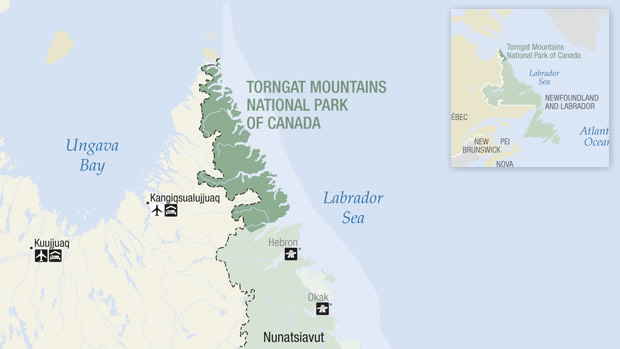
"The Torngat Mountains National Park, northern Labrador, Canada, contains more than 120 small glaciers: the only remaining glaciers in continental northeast North America."
You brought up the point earlier that maybe 1000 years ago there were glaciers in Labrador, 1000 years ago was the medieval warm period, whereas the glacier melting of the Ice Age would have been like 20,000-10,000 years ago. Specifically in Labrador, the Laurentide Ice Sheet disappeared a couple thousand years after the main ice sheet of Ice Age North America melted, as this article notes:
The number of eskers in Keewatin dramatically increased as the Northern Hemisphere climate warmed and the ice sheet retreated, Storrar said. (The Northern Hemisphere climate started warming about 12,500 years ago, and the ice sheet disappeared about 7,000 years ago.) The Labrador section shows a similar pattern, lagging behind by a few thousand years.
Map of the Torngat National Park.
In the Greenlanders' Saga, it's a 3 doegr/day journey from Markland northeast to Helluland, and another 4 doegr/day journey from Greenland to Helluland.
In Eric the Red's Saga, it's 2 half-days' journey from the Bjarneyar south to Helluland, and another 2 half-days' journey south from Helluland to Markland.
The distance from Greenland to the Torngat National, as well as to any little islands off Labrador's east coast, is a bit over 500 miles. The standard Knarr ship distance for a 4 day journey would be 240 miles (5 mph X 12 hr X 4 days), whereas the maximum viking distance for a 4 doegr/day viking ship sail is 624 miles (13 mph X 12 hr X 4 days) at the maximum speed that I've seen, and in the Greenlanders' Saga, the Vikings sail for 4 doegr from Greenland to Helluland. If we suppose that Bjarneyar is on Greenland's west coast, such as Disko Island, then the case for Helluland being north of Labrador's Peninsula becomes stronger. Therefore, based on the Sagas, it seems less likely that Helluland would be the Labrador Peninsula or an island off its coast, but rather would more be a land closer to Greenland, and thus north of Labrador's Peninsula, such as Baffin Island or anorther such island. This is because on a map, all islands closer to Greenland than Labrador is are north of Labrador.
To put it in other words, based on the distances known and possible speeds, it seems that Helluland could be around the north end of Labrador, or else would have to be north of it. On the other hand, if the ships were sailing at standard speed in the Greenlanders' Saga, or if one takes the view that the Bjarneyar are on Greenland's west coast north of Nuuk (eg. Disko Island), then the distances and speeds stated would entail that Helluland must be north of Labrador.
"Markland" would therefore have to de facto be the Labrador Peninsulva. This is because in Eric the Red's Sagas it's described as at least a 2 days' sailing journey from Helluland, which we can deduce is at the farthest south at the northern Labrador Peninsula, and because Markland is also described as 2 days' sail northeast or north from the grape-bearing regions of Vinland in the Greenlanders' Saga and the Wonder-Strands in Eric the Red's Saga. Hence, the land of Markland would have to be at most 2 days' sail north of the grape-producing region of the eastern Canadian Maritimes (St Lawrence Gulf area, Newfoundland, etc.) and also at most 2 days' sail southward from the glacier flat stone lands of northern Canada, such as Baffin Island, the Torngat Park, or the small islands around them. A 2 days' sailing journey would be at the minimum like ~120 miles (5 mph X 12 hours X 2 days) if we are talking about a standard knarr speed, and a maximum of 312 miles (13 mph X 12 hr X 2 days) if we are talking a maximum longship speed.
The Cross Island - Hopedale/Agvituk region of eastern Labrador is about 330 miles northwest of the north end of Newfoundland, which in turn would be conceivably the northernmost end of the land points south of Markland, based on the Sagas' directions (ie. it's 2 days' southward sail from Markland to a landmass and northward cape, etc. in the Greenlanders' Saga). The only way to make a 2 day southwest sail to get to a grape-growing region in North America would be by departing from the Labrador Peninsula. There is no other way to draw a southward or southwestward route like that on a real world map except by departing from the Labrador Peninsula or a point farther south
In other words, the landmass in the Greenlanders' Saga that Vinland is located upon is reached by sailing southwest from Markland, and there is no way to sail southwest to the grape-growing region of eastern Canada except by sailing from the Labrador Peninsula or a place further south.
There is a similar issue for Eric the Red's Saga. In that Saga, the Vikings sailed 2 days southward from Markland and got to Kjalarnes, then sailed east and south on Kjalarnes' coast that became the Wonder Strands, and the Scottish thralls found grapes while searching from there on land. This puts Kjalarnes on either Newfoundland's or Nova Scotia's northern ends, since there were grapes on both, but not further north.
However, if you pick a point further south than the Labrador Peninsula as the candidate for Markland, such as Newfoundland or Nova Scotia, then you would have to compensate by choosing a longer journey southward from the glacier region around the north of the Labrador Peninsula. The whole distance from Torngat Park down to the north end of Newfoundland is 577 miles in a straight line, well over the maximum distance it would take for a two day journey south from the glacier range of Canada to get to northern Newfoundland.
With (A) Helluland being at Torngat Park on the southernmost oceanside point of Labrador and (B) Vinland's landmass and Kjalarnes being at the northernmost potential oceanside point at Newfoundland, (C) the minimum distance between A and B being ~577 miles, and (D) the maximum total two 2-days' journeys covering 312 miles, there is no way for "Markland" to be any other place than the Labrador Peninsula.
In other words, the northernmost region for Markland has to be the Labrador Peninsula because the northernmost candidate for Vinland and Kjalarnes is Newfoundland, from which Markland is a two day journey. And meanwhile, the southernmost candidate for Markland must also be the Labrador Peninsula, because the southernmost seaside glacier area for Helluland is at the north of the Labrador Peninsula, and you wouldn't get past Labrador in a two day southward oceanside journey from that glacier range.
Plus, even if you counted Helluland as an island off the coast of Labrador at the Torngat Park instead of being the Labrador Peninsula itself, you still wouldn't change that southernmost limit for Markland. Furthermore, unlike Helluland, there is no indication of Markland being an island.
So on one hand, there is no way to make Markland to be anything farther north than the Labrador Peninsula, and as for anything farther south than this Peninsula, you would again run into obstacles:
First, you would have to postulate that Helluland would be Labrador or a glaciered island off the coast of Labrador
Second, you would have the potiential obstacle that Labrador and any islands off its coast are far further from Greenland than the standard distance from Greenland to Labrador and its seashore isles and from the theoretical location of Bjarneyar north of Nuuk.
Third, you would have the issue that Helluland is a rocky glaciered "worthless" land but that Labrador's Peninsula is actually well forested in general, despite the northern spot at Torngat park.
Fourth you would have the issue that on Bjarni's journey, Bjarni would be sailing from south to north and thus see the forested part of Labrador before seeing Torngat park and thus be more likely to identify Labrador as forested than to identify it as the "worthless" glaciered Helluland.
Fifth you would have the issue that Helluland is called an island, whereas Labrador is not an island, leaving you to consider Helluland to be a small island off the coast of Labrador.
Six, in the case that you identify Helluland as an island off the coast of Labrador, you would have the problem that the Sagas consider it to be a two-three day's journey from Markland to Helluland, whereas all islands off Labrador's coast would be right next to a big landmass, Labrador. And in that case you would wonder why the Saga mentioned the landmass of Helluland but not the landmass that is Labrador in real geography.
Seventh in case you postulate that Helluland is a glaciered island by Torngat park, you would have the issue that Newfoundland, the hypothetical "Markland" in this scenario, is still 577 miles off of Torngat Park, whereas the maximum sailing distance for the 2 days' journey between Markland and Helluland would only be 312 miles.
Eighth, in order to accommodate the difference in sailing mileage, you could suppose that in the Vikings' time, the glaciers went farther south than Torngat Park, so that Helluland was closer to Newfoundland, but in that case you would have to postulate that the glaciered range went at least 265 miles south in order to make up the difference.
Meanwhile, the farther south that you postulate the location for Helluland to be off of Labrador's coast, the farther that you would have to postulate Helluland to be from Greenland. So if you postulate that Helluland is a two doegr/days' sail (maximum of 312 miles) north of Newfoundland at the Bay of Islands south of Cross Island, Helluland would be 565.50 miles southwest from Greenland, whereas the Greenlanders' Saga counted Helluland as 4 doegr/days (a maximum of 624 miles) from Greenland. And even then one would wonder why it talks in both Sagas as if Helluland was the next land that the Vikings saw after leaving Markland, when in fact if you left Newfoundland to get to an island off of Labrador's coast (like Cross Island or Turnavik Island), you would certainly see the Labrador Coast before getting to that island.
So at this point, deductive logic practically forces one to conclude that Markland is the Labrador Peninsula. To argue in the alternative that Markland is Newfoundland, would create a bunch of major problems as I mentioned above.
Further, to argue an alternative that Markland is just one part of eastern Labrador on the Atlantic coast and not the entirety of Labrador would also create problems, because it wouldn't make sense then how the Vikings could sail two days north or northeast to get to Helluland before sailing from there north or east to Greenland. This is because if you check on a map, the only landmasses that would be north or east of any part of Labrador would be those north or northeast of Labrador's north end. To reiterate, there is no way to make any two day north or northeast voyage from Labrador to get to land without leaving from the north or northeast end of Labrador, particularly at Torngat Park.
Once we've established that Markland is the Labrador Peninsula, it becomes provable that Helluland has to be either Baffin Island or an island right off its east coast. This is firstly because the only point from which one can depart the Labrador Peninsula to reach any landmass by sailing northeast as in the Greenlanders' Saga is the north end of Labrador. Just check a correct geographical map and you can see this very easily. Secondly, the distance is given as 3 days' sail, and in three 12 hour days with a standard knarr speed of 5 mph, one would reach 180 miles. So this can give you an idea of the area where they might have landed on Baffin Island or one of its coastal islands.
Then, finally once we've established that Helluland is Baffin Island or an island right off its east coast, I am wondering whether we can use this information to show where Helluland and Bjarneyar would be, but it looks tricky. Helluland would have to be either Baffin Island or an island on its south or east sides to be reachable by sailing north and northeast from Labrador's Peninsula, ie. Helluland couldn't be an island on Baffin's north-facing coastline because the Vikings would come to Baffin Island before getting to an island on its north coast. Plus, Baffin Island's eastern most point, Cape Dyer, is ~427 miles from Labrador, so it's too far to get to those islands on Baffin Island's north side in 2 days. Nor could it be any island on Baffin Island's southwest side west of Resolution Island, because one could not sail north from there to the Bjarney Islands and to Greenland per Eric the Red's Saga without hitting Baffin Island, or for that matter could one sail from such a westward coastal island northeastward to Greenland per the Greenlanders' Saga without hitting Baffin Island.
By trying to plot routes on a real world map and look for real world options for Helluland, you can narrow down the possibilities at least.
When you say "isles off the coast of America", by "America" I don't know if you mean the USA, or mainland North America (Labrador Peninsula + Nova Scotia + New Brunswick + New England), or British America (US & Canada).
Off the American mainland. If I meant the US I'd say the US.
I'm following what I recall my translations saying. They're saying, as I also mentioned long ago in the thread, that it's either a single island off Greenland, most likely Disko, or its isles off America, in which case we don't know which, but likely small ones that may no longer exist.
That was only in the northern hemisphere and even then it varied how warm it was from area to area.
And it also didn't get that warm relatively speaking. Compared to today it was quite a bit colder for instance.
Specifically in Labrador, the Laurentide Ice Sheet disappeared a couple thousand years after the main ice sheet of Ice Age North America melted, as this article notes:
The number of eskers in Keewatin dramatically increased as the Northern Hemisphere climate warmed and the ice sheet retreated, Storrar said. (The Northern Hemisphere climate started warming about 12,500 years ago, and the ice sheet disappeared about 7,000 years ago.) The Labrador section shows a similar pattern, lagging behind by a few thousand years.
Here is a map of the ice sheet in green at c.6200 BC during what is known as the "8.2 ka event" (ie. 8200 years ago), a decrease in global temperatures:
Here is a tentative map of the retreat of the Laurentide ice shield, with the last, smallest oval being marked as 6,000 years ago, ie. 4,000 BC, in agreement with the Scientific American article. The oval marked 6,000 years ago is on the western, left side of the north end of Labrador:
Caption: "Tentative model of the ice-front retreat of the Laurentide Ice Sheet, in Québec-Labrador, between 13.5 and 6 cal. ka BP. Zone in grey: area from Clark et al. (2000) where pre-late ice retreat forms seem to be preserved, that is, extension of residual cold-based ice or stagnant ice. After the fragmentation of this ice mass, ice disappeared ca. 6 cal. ka BP (see Dyke et al., 2003, for current model)."
Source: "Late Wisconsinan-Early Holocene deglaciation of Québec-Labrador"
The relevance of the ice sheet and glacier zone is that the farthest south that Helluland can be is this limit: the glaciered area of north Labrador, especially Torngat Park. Therefore, the farthest south that Markland could be is eastern Labrador, as Eric the Red's Saga has the Vikings sailing 2 days south (312 miles at most) from Helluland to Markland, and as I mentioned, it's 577 miles as the crow flies from Torngat Park to northern Newfoundland, and a seashore route would be even longer than the 577 miles.
Let's try to figure out Helluland's location's range, with Baffin Island or an island off its east coast being a tentative possibility.
In the last message, we've established that Markland is the Labrador Peninsula or at a minimum a costal eastern region or island on the middle of that peninsula.
Plus:
In the Greenlanders' Saga, it's a 3 doegr/day journey from Markland northeast to Helluland, and another 4 doegr/day journey from Greenland to Helluland.
In Eric the Red's Saga, it's 2 half-days' journey from the Bjarneyar south to Helluland, and another 2 half-days' journey south from Helluland to Markland.
Consequently, Helluland has to be somewhere north of the Labrador Peninsula. This is because there is no way that you can sail for 2 days northeast from a spot in the established range of Markland to get to any landmass that is not east of the Labrador Peninsula.
Even considering the directional variability that the journey from Markland to Helluland in the Greenlanders' Saga could have between a pure straight north direction and a true 45 degree northeast direction, the journey would be no farther west than the slowest journey on a 3 doegr northward direction from Labrador. A 3 half-day journey would cover somewhere from 144 miles (3 doegr X 12 hours/doegr X 4 mph for a slow standard knarr speed) to 468 miles (3 X 12 hr/doegr X 13 mph at an optimal longship speed). You would not be realistic able to sail from any spot west of the southernmost end of Baffin Island to Greenland without hitting another spot on Baffin Island. This allows us to establish the westernmost limit for a journey to Helluland. I am showing this on the attached map with the dark red line.
Similarly, considering directional variability and the calculations above, a 3 day northeast sail could get the Vikings at most 468 miles north from Markland at the fastest speed and northernmost angle, the northermost end point would be at Cape Dyer. This is because it's not feasible to think that they sailed northwest around Cape Dyer without seeing it, as they were sailing northeast. Plus, Cape Dyer is within 468 miles of Labrador and any place within the 468 mile limit that is further north than Cape Dyer and no farther west than it would be open sea, as I am showing with a 450 mile pink line north from the Labrador Peninsula.
A 4 half-day journey would cover somewhere from 192 miles (4 doegr X 12 hours/doegr X 4 mph for a slow standard knarr speed) to 624 miles (4 X 12 hr/doegr X 13 mph at an optimal longship speed). Cape Dyer, the southernmost end of Baffin Island and Resolution Island, to the southeast of Baffin Island, are all within 600 miles of Greenland, so they would all be reachable within the maximum distance from Greenland covered by the journey in the Greenlanders' Saga from Greenland to Helluland. For reference, Cape Dyer is about 200 miles from Greenland, and the farther south that one would travel on Baffin's coast, the faster one would have to sail from there to Greenland.
A 2 half-day journey would cover somewhere from 96 miles (2 doegr X 12 hours/doegr X 4 mph for a slow standard knarr speed) to 312 miles (2 X 12 hr/doegr X 13 mph at an optimal longship speed). Therefore, based on the northern end of the Labrador Peninsula facting the Atlantic Ocean, the northern limit for the journey in Eric the Red's Saga that stretched for 2 days from Helluland to Markland would be around Leopold Island, as I've shown with an Orange line.
Based on those distance limits, then based on the theory that the Bjarneyar were a coastal island like Disko Island on Greenland's coast, the 2 doeger journey from Bjarneyar south to Helluland would take the Vikings to Cape Dyer or a point a bit farther south on Baffin Island's east coast, as I showed with a Yellow Line.
Supposing that the Bjarneyar are in fact an area along Greenland's coast such as Disko Island, then Helluland would have to be Baffin Island itself, and not an island off the coast of Baffin Island. This is because the distance between the Helluland parts of (A) the maximum journey from Markland to Helluland and (B) the maximum journey from Bjarneyar to Helluland is too great for these to journeys to arrive and depart from any other landmass besides Baffin Island. In other words, even if the Vikings were to travel at their top speed for 2 doeger/days from some place like Disko Island and reach an island off Baffin Island's coast by Cape Dyer, that island would be too small to depart from it to get to Markland/Labrador in another 2 doeger/days.
If the Vikings had departed from some point on Greenland farther south than Disko Island to get to Helluland, then the Vikings could reach some more southern area like Leopold Island within the 2 days, but in that case, the author should seem better inclined to refer to the journey as being in a southwest or western journey, rather than a southward one. A second, thinner yellow line shows the trajectory of a 300 mile route almost directly west from mainland Greenland. Such a journey would land near Leopold Island at the southern limit of such an arrival point.
So to recap some parameters on Helluland's possible locations:
1. Helluland can't be on the Labrador Peninsula or one of Labrador's seashore islands because (A) we've identified Markland as including at least the eastern central part of coastal Labrador and (B) the Greenlander's Saga says that Helluland is 3 days' sail northeast of Markland, and Eric the Red's Saga says that Helluland is 2 days' sail north of it. There is no practical way to identify any part of the Labrador Peninsula as an arrival point from such directions on any other part of Labrador's Peninsula that you would get to from eastern Labrador.
2. Thus since Markland is the Labrador Peninsula or part of it, Helluland must be north of the Labrador Peninsula.
3. Looking at the Macro Level, where the Saga names different major-sized "lands" (Bjarni's First Land = Newfoundland, Markland is the Labrador Peninsula, the Vikings visit Greenland and Iceland), a preliminary candidate for Helluland would be the major sized landmass of Baffin Island.
4. In case Helluland would be a literal island smaller than Baffin Island, there is a limit for where the island could be:
A. The farthest west that Helluland could be would be about 624 miles west of Greenland, as it took 4 days to sail from Helluland to Greenland in the Greenlanders' Saga (4 doegr X 12 hrs X 13 mph). Big Island on Baffin Island's south side is 618 miles from Greenland by sail, although one would have to sail from Big Island around the south end of Baffin Island to complete the trip. Baie Tursujuq on the north side of Quebec is 628 miles from Greenland by a sail. So Big Island and Baie Tursujuq mark the western limit for Helluland, based on the time that it would take to sail to Greenland at the top speed.
B. The farthest north that Helluland could be according to the Greenlanders' Saga would be Cape Dyer, as a sailing trip to an island any farther north within the limit of a 3 day trip, 468 miles, would have to travel north from Labrador and then counterclockwise from north to west around Cape Dyer, whereas the Greenlanders' Saga has the Vikings simply traveling northeast from Markland / Labrador. Even if it they sailed 468 miles north from Labrador and then around Cape Dyer, the total shortest sailing distance would only take them to Red Bay, a bit northwest of Cape Dyer.
C. The farthest north that Helluland could be according to Eric the Red's Saga would be around the area of Leopold Island, which is 306 miles north of Killiniq, Labrador, due to the 2 doeger trip in that Saga from Helluland to Markland.


")