

Yup, good to knowGood to know. I know that these oasis were institutions on their own, and there were two administrative divisions in Roman Egypt for Oasis Parva and Oasis Magna (Magna being the union of the Kharga and Dakhla oasis), so I thought it was fitting to have a duchy for them. It also works well with the setup.
")
Your motives are understandable. So let's think about possible solutions:I know, but I tried to do bigger provinces. If I had it my way I'd have the strip of land around the nile and desert everywhere else.
But I have drawn it this way for two reasons:
1- Visibility and clarity: to give the appearance of a developed state structure that can control the hinterland.
2- If I draw the river provinces strictly into the fertile area around the Nile, then I don't really know what to do with the hinterland. Adding more provinces in the desert seems like a waste. I could expand the coast ones, yes, but that would looks funny. In Ptolemais and Hermopolis, for instance, I used the range around Mons Claudianus as a natural border for the provinces and their "reach" into the desert. There were quarries there, therefore population, centers of work and transporation, etc:. Here's one of the maps that shows the quarries and trade-and-transport centers:
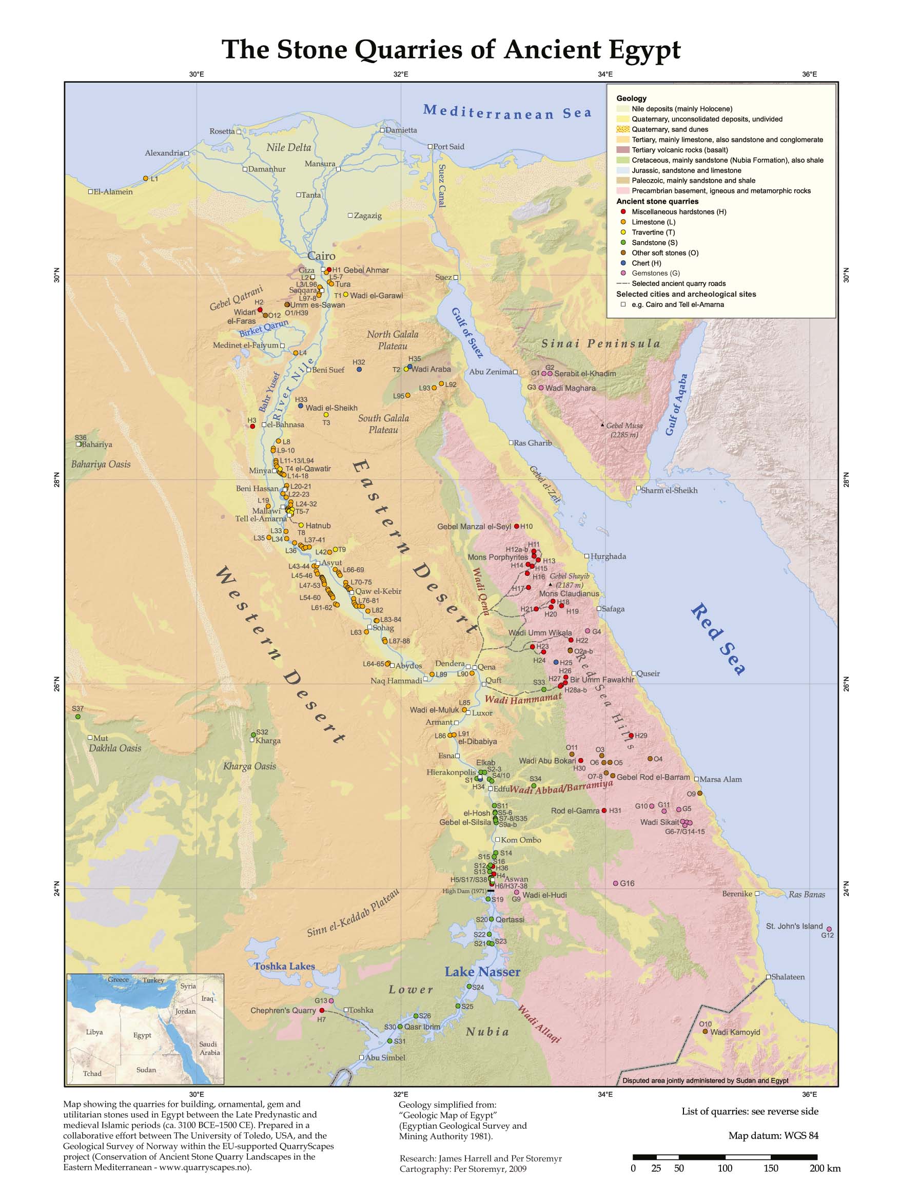
But I can rework it, of course. And I agree that the Lybian Desert provinces probably should keep their borders closer to the Nile... I can rework it so that the province Porphyrica/Porphyritia engulfs all those quarries, although then Egypt would have direct contact with the Red Sea shore, and that shore was (or appears to have been, I've never bought it entirely...) quite devoid of Egyptian, Ptolemaic or Roman activity. The Red Sea Hills are very inhosipitable, but over the years some systems of hostels and small herdsmen villages could have developed, makign the trip easier...
1) how about to make the mountainious area between the coast and the Nile a separate province/s? It might well simulate both hinterland and the riches of Egypt on the Nile. Giving those provinces only 1-2 provinces would well represent how poor they were and they would in most cases be occupied by the rulers of Egypt propper. The positive of this setup may be (if connected to some tribal-nomadic mechanic) that it may help to simulate the problems the Egyptians had with nomads living just next to them - in the desert/hills east/west of Nile.
2) not really a solution, considering preferences of other LI mapmakers, but still - you can make those inhospitable areas or parts of them (like I did in SWMH) a wasteland
3) really pushing the border little closer to the Nile. I mean not entirely, because I admit that the visibility is a big concern too - for instance in my own SWMH setup I really dislike to see the Lawata Berbers on the western (desert) shores of Egypt to be more visible than Tulunids who control the (not so) narrow strip around the Nile.
While in Europe and other regions the mountains were the border-making/divisive factor, here in Egypt and MiddleEast they were only partialy. From the perspective of agricultural societies of Egypt and Syria it was the deseert.
But as I said, there are various factors which influence the final look of our maps.
For instance the suggestion 1) requires more ballancing like terrain etc. so that armies marching down Egypt would turn into the desert only if they really want to cross it etc.