• We have updated our Community Code of Conduct. Please read through the new rules for the forum that are an integral part of Paradox Interactive’s User Agreement.

Rzeczpospolita3Narodów

Second Lieutenant
7 Badges
Sep 18, 2015
199
79
  • Crusader Kings II
  • Europa Universalis IV
  • Hearts of Iron III
  • Mount & Blade: With Fire and Sword
  • Hearts of Iron IV: Cadet
  • Crusader Kings III
  • Crusader Kings III: Royal Edition
Hey guys! i think there very unhistorically provinces, and veeeery big..:) So i offer new provinces, not need make all of this, but a half of this would be nice!
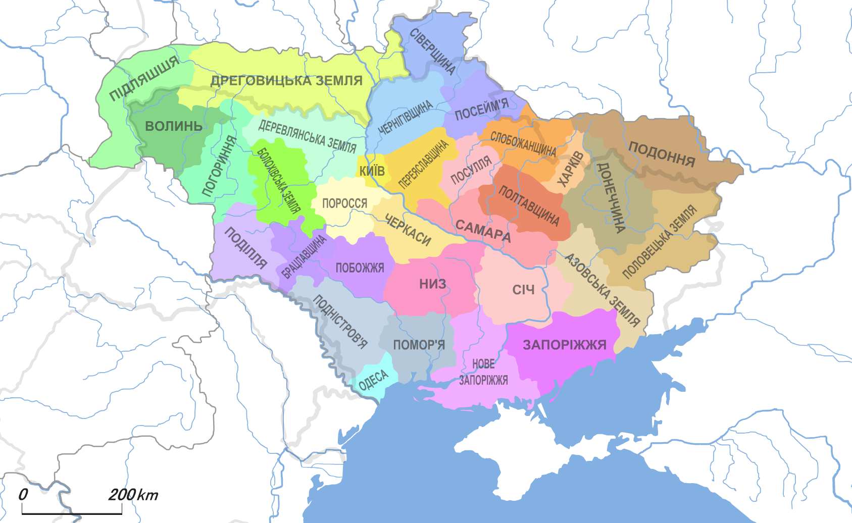
Provinces(adm. division of ukraine on 1918):
UNR_1918_divisions-1.png

UNR_1918_divisions-0.png
Cultures:
lithuania1568.gif

a8-YlqxxZ8M.jpg
fgyPZxt0IPA.jpg

sgpr4g.jpg
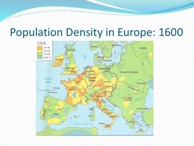
population in Conmmowealth:
6wuIaZoNq6A.jpg
some maps which i hope help for you:
7dijKdhHtwM.jpg
u-NU71j7O5M.jpg
 
Last edited:
  • 9
  • 3
Reactions:
Upvote 0
Keep in mind that, the steppe was very depopulated and devastated economically in this period. Almost constant Tatar raids had basically destroyed the economy of the region and made huge swaths of rich fertile land a virtual wasteland.

experiences-of-life-in-early-modern-europe-9-638.jpg


The above map is not a great resolution, but it gives a decent idea of the relative density of population.

I can understand adding more Provinces for gameplay reasons, but adding more development than strictly necessary is unrealistic. There is just not enough economic value, or just raw people living in the area to justify it. In fact it wasn't until the 17th century until the members of the Szlachta/Lithuanian Boyars even thought to start claiming land there*. That's how empty and devastated the region was.

Edit: * By this I mean colonizing the empty fields and bringing in serfs to work the region. Even then, it was not a huge influx of people, though it did inflame tensions with the Cossacks.

Nice, on your map Balkans, a small part of Anatolia, Hungary, Poland-Lithuania, Muscovy-Novgorod and Baltic sea have roughly the same pop density. Still look ta Hungary, look at Scandinavia and compare to Eastern Europe.
 
Nice, on your map Balkans, a small part of Anatolia, Hungary, Poland-Lithuania, Muscovy-Novgorod and Baltic sea have roughly the same pop density. Still look ta Hungary, look at Scandinavia and compare to Eastern Europe.
I agree, in the 15th century Hungary was way more populous than that. That map shows it after ~80 years of Ottoman invasions. By 1600 a huge percent of the population perished in middle-Hungary.
Under Matthias Corvinus, the core area of the Kingdom (without his conquests) had around 4.000.000 inhabitants. England had something around 3.000.000 AFAIK.
While significantly less populous than the Kingdom of Hungary, the territories of the Old Rus' were still more densely populated than most parts of Scandinavia. Norway had around 250.000 population...

England had well over 5 million people, as they reached five million in the late medieval period.

Also keep in mind 10-30 people/mile^2 is a huge variance in pop density. So most of your complaints are a result of such an approximation of the map.

Edit: used the wrong unit, the map is in square miles!
 
Last edited:
England had well over 5 million people, as they reached five million in the late medieval period.
We are less than a century after the Black Death. Most sources I read state that the English population was somewhere between 2.5 - 3 million people in the mid 15th century.
Surely we don't have exact data, but 5 million is probably a way too big guess.

Nevertheless that's not the point. What we can safely say is that the map above is way too arbitrary.
I can't even put the orange color for Ireland anywhere. Wasn't it very sparsely populated up until the introduction of potato?

EDIT: One more thought about England: even wikipedia lists them as 3.3 million in 1450, together with Wales!
https://en.wikipedia.org/wiki/Medieval_demography#Demographic_tables

I don't trust those Wikipedia figures, first they are from a source from 1941 which is likely outdated. Second my numbers are from estimates I've been told from my late medieval history professor as of last month, who specializes in the period (more specifically in the British Isles).

Also Ireland was always a fairly densely populated island, furthermore 1600 is after the introduction of the potato to Ireland, though only by 11 years. For the most part the map is in the ball park for the density of Ireland as its population pre-Cromwell was ~2 million.

On whether the map is too arbitrary or not, I never posted it as a definite statement. Instead I posted it as its *reasonably* good and gives you an idea of the population density. Also keep in mind its in square miles and has very large data ranges. Basically don't look at a reference and hold it to a high standard, as it was never intended to be used that way.
 
Some thoughts as an economist and Ukraine geek:

Just wanted to pop in and say that as always we keep track of map suggestion threads but cannot promise any changes in particular.
The maps in this thread are a bit more modern than I like, for Poland and Lithuania we've leaned on PLC administrative divisions as well as post partition divisions for inspiration in the past, of course that's not always going to work out so well in places like the wild fields (and we haven't adjusted provinces there since version 1.8 I think) so feel free to press on specific changes you'd like to see.
Eastern European development (and plc development in particular) has been adjusted a lot both up and down during the course of this games lifespan, it is as always a constant balancing act to get it where it's both fair in the long run and in 1444. There are still frequent cries to decrease the plc development even now so it's apparent the community is pretty divided on this itself.
If you feel it should be changed again please argue for it in detail and we will as always consider it :)

This long run-1444 dilemma really is the key with Ruthenia, even more so than other parts of the map, isn't it? There's this contradiction within Ruthenia whereby the steppe-cossack state organisation was a huge obstacle to fully developing the natural wealth and potential of Ruthenia - but the features of the terrain and actions of the local population made that steppe-cossack state so effective and allowed both the Tatars and the Cossacks to punch far above their weight as independent actors. The problem is not really whether Ukraine was historically rich or poor, but that the way "Ukraine" was organised as a society was so different to other states at the same time but this suited their local environment.

What this implies is that A) the Tatars and Cossacks should be far more powerful than they currently are on the steppe itself B) over time the advantages they possess should diminish relative to the other Eastern Europeans C) fully consolidating Ukraine should unlock much more development.

The addition of Ukraine to the Russian Empire put Russia's great power status in an entirely new gear, because of a combination of the natural wealth (soil, industry), migration to Ukraine (from all over the place - Greeks, Serbs, Russians, Jews, Germans, and other Ruthenians/Ukrainians), but also unlike the rest of the steppe that Russia had conquered Ukraine had exposure and easy access to world markets through the sea. Russia was the world's leading grain exporter in the 19th Century with very poor tech because of the sheer scale of Ukrainian grain output, and this is really the kind of benchmark you need to be setting for a properly developed Ukraine. This is in contrast to Belarus which remained incredibly underdeveloped right up until the mid-20th century.

So, a checklist for properly balancing Eastern Europe as a whole would be, in the early game:
  • Tatars and Cossacks should be militarily buffed in the early game relative to non-tribal states on the steppe (eg manpower boosts from escaped serfs for Cossacks and converts for Tatars, stronger cavalry).
  • Occupying and fighting on land for non-tribal states in the region should be difficult, and vassalising the Cossacks as PLC/Russia etc is an important way to gain an edge over other powers in the region.
  • So they don't blob, the tribal states should find it extremely difficult to rule over provinces which don't have an accepted culture, and their list of accepted cultures should be very short.
  • Attempting to diploannex either Crimea or the Cossacks/any tribal-steppe state when they're vassalised should create a massive headache for everyone in the region. "Support independence" should be a very common kind of war in the region.
  • The steppe is poor so long as the tribal states exist. Migration occurs but is minimal.
  • Religion should be more and less important than it currently was - this was part of the world where Catholicism, Orthodoxy, and Islam all bordered each other, and the results were messy. For Cossacks to ally with the Turks or the Tatars was a big deal, but possible - for Poles to ask them to convert to Catholicism was intolerable. At present, these things are the wrong way round (should Cossacks have a high heathen tolerance but a low heretic tolerance?)
And later in the game:
  • The military advantage the Cossacks/Tatars enjoy over the Poles, Russians, and Turks on the steppe should rapidly diminish in the late 1600s and be gone by 1730.
  • Securing all of Ruthenia as a non-tribal state (whether Polish, Russian, Turkish, or even Tatar or Ruthenia!) should begin a process of Ruthenia's development increasing rapidly due to events, particularly thanks to migration.
  • Switching to a non-tribal state for Cossacks and Tatars should be more difficult (and less desirable until later in the game) than it currently is - it shouldn't be possible in the mid-1500s.
  • Access to trade and an open Bosphorus is important for Ukraine's development.
The effects of all of this would be:
  • War is harder for everyone else and easier for the cossacks - diplomacy is more unpredictable, and death-spirals are weakened.
  • Ruthenia is poor for most of the game, and owning parts of Ruthenia is not a huge advantage, but it is a huge asset once it has been conquered and secured.
  • The Bosphorus becomes the next goal for any European power which takes Ruthenia - either to conquer it and open it up to ships, or to humiliate a weakened Turkey and force them to keep the Bosphorus open.
  • The game becomes much more fun for Cossack/Tartar players.
  • Balance is improved, not just between the different countries, but throughout the arc of the game in both Eastern Europe and Europe as a whole.
 
and? In asian steppes provinces like in eastern europe. Plus i think need just make system the provinces without development. Exemple with 0-0-0, is will realize the history too, when you big blob, but dont have nothing. But need make the more provinces, is realy make game more interesting, dinamic, and historicaly!!

This is an interesting thought. With the changes to how development is displayed the whole development map looks red now. If they made the 0-5 development more in depth on the screen that would be good. A possibility could doing something like raising everythings development by 6 they can add new provinces that only have 1 1 1 by splitting those provinces that only have 1 1 1 but are vast. This may also have the effect of allowing wasteland provinces to have development.