• We have updated our Community Code of Conduct. Please read through the new rules for the forum that are an integral part of Paradox Interactive’s User Agreement.
elvain said:
btw:
the names you wrote, BorisK, they are Spanish - German - Latin.. am I right?
but I supose those are names of tribes rather than regions, aren't they?

also I came across some problems in getting PhotoShop so I still do this all in Windows paint what's not very ideal...

Hello,
Well... yes, the names are spanish-german-latin, latin comes from

http://www.columbia.edu/acis/ets/Graesse/orblatn.html#Nordalbingia

Yes, in the beginning were saxon tribal territories (until 8o4). In 804 after defeat the nordalbingians and begin the famous deportations of Widmodia, etc., Charlemagne founds the counties of Dithmarschen, Holstein y Stormarn and give it to the abodrites slavs. Later on slavs are expelled and became eclesiastical divisions depending Archbishopric of Hammaburg, with concrete limits as you can see in the map. This is my work (804-810).
I have red in the ESPASA_CALPE (is the bible-enciclopedy in spanish language), that Oton I defeat the wagrians slavs (abodrites too) and found the bishopric of Wagrien or Wagria incorporating it to Holstein. If you go on in medieval history, the names of Storman, Dithmarschen, Holstein and Wagria apear continuously as parts of Holstein. As counties or historical divisions of Holstein. Other thing are the imperial free towns of Hamburg and Lübeck.
In your map I recognize:
-Dithmarschen county
-Hzm. Holstein
-Territories of free imperial towns of Hamburg and Lübeck.
-Hzm. Lauenburg

My opinion is that if you include Dithmarchen in the map, you have to include too Wagrien, Storman and Holstein.

I hope it will help you...

PD
I think that is better to work with vectorial programs like Free Hand or Adobe Ilustrator because bipmaps programs, with pdf. archives by example, are too heavies and slow for this kind of maps.
 
Last edited:
elvain said:
that "province south of Härjedalen" was just caused by coexistence of 2 maps being put one on another. it is NW part of Dalarna/Dalecarlia which in older times was part of Norway (according to most of maps of Scandinavia I have seen) It has no name and it is there just because the map is indefinite
That part of the map (the area around Sveg) was Norwegian and a part of Herjedalen until Sweden conquered Jemtland/Herjedalen (1645). There was no treaty establishing Swedens claim on that area but they sent in armies and de facto controlled it until it was formally annexed by Sweden in some later treaty (can't remember which). Today, Sveg is a town in Dalarna (Dalecarlia) and that's why it's often confused.
 
Last edited:
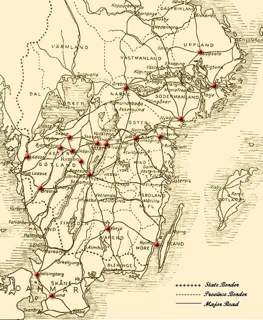
My translation of a quote by Snorre Sturlason and a map from my old court in EU:M, this might help you.

Snorre Sturlason said:
"The realm of Svitjod (Sweden), Snorre says, is divided into many provinces. One of these areas is Västergötland, Värmland and the Marks (Dal, the forest parts near Norway). It's such a wide realm, that one diocese who lives there has over 1100 churches as subjects. The second area is Östergötland, where the other diocese is with Gotland and Öland. The last two islands alone together are larger than a normal bishopric. In Svitjod proper there is an area called Södermanland, also a diocese. Then there is Västmanland or Fjerdhundraland, also a diocese. Thereafter is Tiundaland, the third part of Svitjod proper. The fourth province is called Attundaland. Then there is Sjöland (Rodland or Roslagen). The fifth area is everything east of Svitjod."

provinces.jpg


Source: http://www.wadbring.com/historia/index.htm
 
here is Maghrib:


maghribjm7px.png
 
One word:

WOW!

First time I've heard of this project; how ignorant of me :(

Either way, this is perfect for the Medieval Universalis mod - would any of you chaps like to help, as it seems to fit my timeline pretty well: 1066 - 1453.

I can't believe this project exists, it's great. I just hope to God it works okay when you test it out.

Jim :)
 
the project is not a map for any mod. It is just collection of all medieval regions of Europe and surrounding territories.

It is to serve as a base for other maps.

Some regions are complete (Arabia, Egypt, Maghreb, British isles, Bohemia and Italy), other are mostly around 80%
 
I updated the map i n the first post:
romeresizeht3.gif

(for those who watch map development of Arabia Universalis nothing very new, though :( )
 
Can you please tell me when do you expect to have it done for Knights of honor?(it is also for Knights of honor isn`t it??I think there was a forum thread in knightsofhonor.de if not sorry for the offtopic)
 
iot is not for Knights of Honor but the game inspired my research which led to this project and I would like to use it for the game too

btw, if you know, there was announced second patch for knights of honor and it seems that the developers will teach us how to use map editor so I could use this project for KoH

PS: KoH has own sub-forum here on these boards...
 
second patch where where??????? :eek:.I hope they do(teach us)
ps: i check their site every week,nothing new lol
ps:it`s a pity it isn`t for koh
 
check Knights of Honor section on this board or official KoH board

I hope that in Editor I could load actual KoH map and extend it to the middle east.. and change it a little :)

PS: I will do my best to use as much of this project for KoH...
 
"I hope that in Editor I could load actual KoH map and extend it to the middle east.. and change it a little :)

PS: I will do my best to use as much of this project for KoH.."
I already found the koh forum here and read about the patch,thanks however.I would really appreciate i you made an alternative map for koh ,this one is kind a small with very few territories to conquer especially in south-eastern europe.
My homeland(Bulgaria) is about 5 territories :( ,i tought there were a lot more people in this region of europe in the mid ages :confused:
ps: thanks for adding the bulgars as a unit in holy roman!It was strange they weren`t added in the original version of the game
 
When Europe + Mediterranean have only 168 provinces there is not much space for no region

I would like to make small regional maps (The Balkans, HolyRomanRmpire, Italy+West Balkans, Middle East, Britain+NorthFrance) for multiplayer but now I can just hope it would be possible
 
update on the map:
auromeresizepf5.png


West Iran:
westirannamesresizevd1.png


Fertile Crescent and Caucasus:
neareastresizenamesot9.png
 
Last edited:
the red line is border of PTI for Arabia Universalis. I was just too lazy to remove it :D
 
here are some new maps for those who are interested in the project or in Middle Eastern history:
mehijraresizelb8.png

me811resizeld5.png


sorry that the thread is moving to be more Regions of Medieval Middle East in last several months, but after I finnish this to cover all/most of the map I will start fixing the regions that are done