• We have updated our Community Code of Conduct. Please read through the new rules for the forum that are an integral part of Paradox Interactive’s User Agreement.

Mallos

Private
Jun 26, 2025
12
49
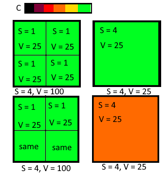
So, what do I mean by area based maps? I mean maps which show some value per pixel instead of per location. So, if c = location color on a map, s = location area and v = location value (population, devastation, development, etc. depending on map mode), k = some coefficient, in per-location maps c = v * k while in per-province ones c = (v / a) * k.
1753085364748.png


For example, here first four location each have a size of 1 and population of 25 while another one has size of 4. If we insert these values into the formula we get that colors of both locations will be the same even though population density in first four locations is obviously bigger. Note I'm not talking about area of arable land, real-life area, etc. I'm talking about amount of pixels player sees in game. If we insert the same values into the second formula we get c = 25 / 1 * k and c = 25 / 4 * k or c = 25 * k and c = 7.5 * k, so bigger location with the same population looks darker.

How can both maps can be used? The location-based one is better for, well, location level stuff, like checking which location is better to take in a peace deal or whether it's possible to build a new city (as amount of pixels has no impact on city size). Area-based maps, on other hand, are more useful in less "zoomed in" situations. For example, when deciding broadly which area to invade or checking how developed other nations are just by looking at their color in corresponding map, which may be much less useful in cases like I described previously (where two areas of the same size are shown as the same color even though one has 100 population and other only 25 due to different location density).

Of course, I don't want full replacement of per-location maps with per-area ones: the former are still useful in most cases. But making the latter an option would be useful too.

Edit: rewrited the post.
 
Last edited:
  • 4
  • 3Like
  • 1
Reactions:
I dont know if you want to get another map mode of if you want to get rid of locations and replace them with provinces or areas.

Can you rephrase your suggestion and maybe add a screenshot (if possible) from the current system that you want to have changed?
 
  • 1
Reactions:
Basically OP means that should be a density variation of maps (e.g. population) that counts the numbers per area (or pixel) vs per location. It does make a difference in immersion, as a country with low location density (e.g. Golden Horde) can show same density as a country with higher, just because the locations are bigger. Since the world has quick varying location sizes even on the same continent, I would like that. It would make places like the HRE better when you think about density land-wise and not location-wise.
 
  • 4Like
Reactions:
Aside from immersion, a map mode that shows "<some value> per pixel" is useful gameplay-wise, too. I'm gonna try to rephrase OP's argument:

Imagine we are playing EU4 and there are two countries, A and B. We want to determine which one is wealthier by comparing their total development using the development mapmode. Now, A has 10 provinces and B has 5 provinces, but B's provinces are twice as large, so A and B take up the same size on your screen.

Let's say all of A and B's provinces have a development of 3. That means that at a first glance, A and B seem like they have about the same amount of development, because all their provinces are colored the same on the development map, and the countries are of equal size. This is incorrect, of course, because A has 30 development but B only 15; A is twice as wealthy. You need to more closely inspect the map to see that B's provinces are larger.

Now what if there was a "development per area" (DPA) mapmode, as suggested? Then, since B's provinces are twice as large as A's provinces, their DPA would be half that of A's. That means B would accurately show up on this mapmode as having half the development of A. Additionally, if all B's provinces had a development of 6 instead, then B's development would also accurately show up as being equal to A. Basically, a DPA mapmode would be much more intuitive to use if you're doing a large-scale overview.

Of course, this is not an issue if all provinces are the same size, or at least similarly-sized. But as we've seen in the map overviews, EU5 location sizes vary a lot, even between regions that are near each other (for example, between Tibet and China). That's why area-based mapmodes makes some amount of sense in EU5.
 
  • 5Like
  • 3
Reactions:
Aside from immersion, a map mode that shows "<some value> per pixel" is useful gameplay-wise, too. I'm gonna try to rephrase OP's argument:
There's a better way to do this: map modes that display the relative total values of a nation compared to yours. ie: Your nation is blue, nations with lower total population are orange/red, ones with higher are green.

The OP's idea is much less clear: if my nation is small and green, does a nation that's 4 times as big and yellow have more or less population than me? If you want to know for sure, you have to look at the numbers, which is what you would have done if the map mode didn't exist in the first place.
 
  • 1
Reactions:
Aside from immersion, a map mode that shows "<some value> per pixel" is useful gameplay-wise, too. I'm gonna try to rephrase OP's argument:

Imagine we are playing EU4 and there are two countries, A and B. We want to determine which one is wealthier by comparing their total development using the development mapmode. Now, A has 10 provinces and B has 5 provinces, but B's provinces are twice as large, so A and B take up the same size on your screen.

Let's say all of A and B's provinces have a development of 3. That means that at a first glance, A and B seem like they have about the same amount of development, because all their provinces are colored the same on the development map, and the countries are of equal size. This is incorrect, of course, because A has 30 development but B only 15; A is twice as wealthy. You need to more closely inspect the map to see that B's provinces are larger.

Now what if there was a "development per area" (DPA) mapmode, as suggested? Then, since B's provinces are twice as large as A's provinces, their DPA would be half that of A's. That means B would accurately show up on this mapmode as having half the development of A. Additionally, if all B's provinces had a development of 6 instead, then B's development would also accurately show up as being equal to A. Basically, a DPA mapmode would be much more intuitive to use if you're doing a large-scale overview.

Of course, this is not an issue if all provinces are the same size, or at least similarly-sized. But as we've seen in the map overviews, EU5 location sizes vary a lot, even between regions that are near each other (for example, between Tibet and China). That's why area-based mapmodes makes some amount of sense in EU5.
I am sorry, but I can't think of a single time where I would want to use that instead of a ledger or in case the information should be relatively obscured a systems that gives me relative values (e.g. stellaris, HOi4) and i can increase my informationlevel through spies. Like what's the point in getting population numbers instead of economic and military information which directly tell me how well I would compare to that nation.