• We have updated our Community Code of Conduct. Please read through the new rules for the forum that are an integral part of Paradox Interactive’s User Agreement.

Tinto Maps #11 - 19th of July 2024 - Scandinavia

Welcome everyone, today I’ll talk about the Scandinavian region. Part of it was the first maps we drew for Project Caesar back in early spring of 2020. Today we will look at all parts of the Scandinavian Peninsula (including Denmark & the Kola Peninsula). Greenland & Iceland will be looked at in a separate map talk.

Countries
SCA_countries.png

Scandinavia has only five location based countries at the start of the game. Denmark, who is in a bit of a crisis at the moment and their vassal Schleswig is in the south. On the peninsula proper, we have Sweden and Norway who are in a union at the moment as they share the same King. Scania was sold off to Sweden by the Danes five years before the start of the game.

There is no need to show off a Dynasty map, as Denmark does not exactly have a ruling King at the moment, and the rest is ruled by Magnus IV of the Bjälbo Dynasty.

Locations

sca_northlocations.png

sca_eastlocations.png

sca_westlocations.png

sca_centralocations.png


sca_southlocations.png

While Scandinavia has a lot of locations, we have to remember that this is a huge area, and together with Kola & Karelia, it is the same size as France, Spain, Portugal, Italy & Benelux together.. The size of locations are smaller in the south, particularly where the population was and still is relatively bigger.


Provinces
sca_provinces.png

We have tried to follow historical traditional province borders here, but some ended up too big like Småland, Lappland or Österbotten, which were cut into pieces, and some are just too tiny to matter.

Now I wish I had time to write up a history about each province here, but I’ll just add a few fun tidbits.

Satakunta, which is the Finnish name, is named in Finnish like the old regions of Svitjod, which were divided into “hundreds”. It was also refered to Björneborgs län, named after Björneborg (Pori in Finnish), a town founded by Johan III when Ulfsby was no longer accessible from the sea. The regiment from the area was the last Swedish Army Regiment that has ever won a battle inside Sweden, and their military march is a song I think every Finnish Citizen want to play repeatedly on TV during the Olympics..

Småland, which is divided into Tiohärad and Kalmar Län here, should really be referred to as Småländerna, as there were 12 small countries there.. Compared to the 3 other much larger countries of Svealand, Östra Götaland and Västra Götaland. And now why is Östra Götaland not containing Kinda?

Topograhy
sca_topography.png

It's mostly flatland.. I went by the rule that if the peaks are less than 500 meters it's flatland, and you need to have over 1,000 meters and rather uneven to be a mountain. Norway is interesting there.. We do have a lot of impassable areas in Norway, making this one of the most fun parts to play in.

Vegetation
sca_vegetation.png

There are some farmlands in Denmark, Scania and in Götaland, but the rest is basically a big forest.. And up north it's even worse.

Climate
sca_climate.png

Yeah, well. There is a reason I moved to Spain..


Cultures
sca_culture.png

Most of the north east is still Sami, and the Finnish tribes have not unified into the more modern Finnish culture. We decided to call the modern Meänkieli with their more ancient name of Kven. We still have Gutnish on Gotland, but the Norwegian, Danish and Swedish cultures have been becoming more monolithic already.

Religions
sca_religion.png


The Finnish are mostly Catholic, but the Sami, Tavastian, Savonia, Bjarmian and Karelians are mostly still following their old pagan beliefs. There are still some Norse people in the forests of Dalarna and Västmanland..

Raw Materials
sca_rawmaterials.png

It is mostly lumber, fish, wild game, fur and iron. We of course have the famous copper mountain as well.

Markets
sca_market.png

Scandinavia is divided by the rich markets of Lübeck and Riga. A strong Scandinavian country will probably want to set up their own unified market.


Population
sca_pop.png


Not many people live up in the north..
sca_eastpops.png


sca_west_pops.png

sca_south_pops.png

I liked nice round numbers as estimates, but the team I hired for content design are mad men, and wanted the distribution to feel more organic.. For the far north of Scandinavia we know that people were semi nomadic, and that some people lived there.. But if it was 100 there, or 250 there or 20 there it's just guesswork..


And let's end with a quote from the Greatest of Poets..

Jag vill, jag skall bli frisk, det får ej prutas,
Jag måste upp, om jag i graven låg.
Lyss, hör, ni hör kanonerna vid Jutas;
Där avgörs finska härens återtåg.


Next week Pavia is back with some German maps…
 
  • 166Like
  • 67Love
  • 6
  • 4
  • 2
Reactions:
Thanks for that, clearly you have great expertise. Just one question.
Some of this area is now under water.
Given that the land in Finland tends to rise after being pushed down in the ice age, turning seabed to dry land, what happened in Viipuri?
 
Thanks for that, clearly you have great expertise. Just one question.

Given that the land in Finland tends to rise after being pushed down in the ice age, turning seabed to dry land, what happened in Viipuri?

I recall reading that part of the area is now under water, but that's a good question to which I have no answer. It's not impossible that I've misremembered.

Also, there's some more information on what I wrote about in my previous post in this Viipuri's Finnish Literature Society (VSKS) text by Viljo Nissilä here, uploaded by the society onto the Wiipuri website, itself a VSKS portal.

While we both agreed in-game Kexholm borders should match the post Treaty of Stolbovo borders, it could add some flavor to represent the older border in the game, especially because it almost became part of the official border between Sweden and Russia.

It could, but it would likely require a rather small "state" to be added just to facilitate the relatively small area of the de jure Korela Uyezd left outside of Kexholms län, which in in-game terms probably isn't worth it. It depends of course on whether states will work similar to how they've worked in other PDX games thus far.

That aside, I just wanted to mention that I am happy about my feedback regarding the border on the Karelian Isthmus and the impassable territory in East Karelia evidently having been taken into account. Now in the newer "dev diaries" the southern border on the Isthmus is correct (the border could still cut through Retusaari Island (Kotlin Island) like it did historically at least since c. 1400 to 1617/1721, but I understand if the island is too small to represent that), and the impassable territory in East Karelia looks to be gone.
 
Last edited:
  • 2Like
  • 1
Reactions:
It could, but it would likely require a rather small "state" to be added just to facilitate the relatively small area of the de jure Korela Uyezd left outside of Kexholms län, which in in-game terms probably isn't worth it. It depends of course on whether states will work similar to how they've worked in other PDX games thus far.
Not a problem because you can take individual locations in peace deals:
Peace Treaties
A peace treaty can be the transfer of a location, province or area. It can also be to force another country to stop sending privateers, or transferring gold to you, or dismantling fortification in a location, humiliating them or any other of the dozens upon dozens of possible peace treaties of Project Caesar.
It's great that provinces don't have to be divided ahistorically into smaller provinces just to allow the creation of certain historical country borders.
 
  • 2
  • 1Like
Reactions:
Not a problem because you can take individual locations in peace deals:

I was thinking more of the economic and demographic implications. As an example in Vicky you don't want many small states with small populations because it messes with the POPs in some funky ways, at least that was the case in Vicky 2. But we'll see.
 
Last edited:
The letter Å/å was introduced into Danish and Norwegian in the last century and should be replaced in all instances by Aa/aa.

Jämtland is the Swedish name of a province that at this time belongs to Norway. I'm not sure what the Norwegian name would be, but it wouldn't contain an ä.

Bergenhus Län should be Bergenhus Lehn. Blekinge should be Blekyng. Bohus Län should be Baahus Lehn.

Funen should be Funen & Laaland. Göinge should be Gønge.
So apparently, the Scandinavian languages in 1337 were close enough to each other that we can still effectively speak of them as different dialects of Old Norse. So how about we just use the Old Norse spelling for all of these and a whole bunch of other names?


And by we I mean someone who speaks any of these languages natively and would have a much easier time than me compiling a list of changes.
 
  • 1
Reactions:
So apparently, the Scandinavian languages in 1337 were close enough to each other that we can still effectively speak of them as different dialects of Old Norse. So how about we just use the Old Norse spelling for all of these and a whole bunch of other names?

And by we I mean someone who speaks any of these languages natively and would have a much easier time than me compiling a list of changes.
This was discussed earlier in the thread. @Johan said older names are preferred, but it's never been confirmed that names will change automatically with time, so there was some understandable pushback.

I am confident that I could change most (if not all) the Norwegian location-names into their old forms, given that I can easily read both modern Norwegian and Old West Norse, but at this point I'd need some clarifications from the devs first.

Like, are the old names still preferred despite the pushback in this thread? Will they change automatically into more modern forms over time? Should completely archaic letters (like ǫ and œ) that will just confuse people be modernized or left as is?
 
Last edited:
  • 2
  • 1Like
Reactions:
Fredrikshamn got its name from Frederick I, a Swedish king who in 1337 wasn't even a twinkle in his father's eye, a father who also wasn't even a twinkle in his father's eye, a father who also... you get my point. It should be renamed Veckelax.

Hedmark should be enlarged with Idre.
Bohus Län should be Baahus Lehn.

Göinge should be Gønge.
After further consideration, I think Bohus Län should be renamed to Ranafylke and Göinge to Gladsax & Gønge. Malmöhus should be enlarged with Borghandæholm (Hammershus) and renamed to Malmø & Borghandæholm. (To be more precise, they should be renamed to the Old Norse version of those names, but I don't know what those were.)
 
  • 1
Reactions:
After further consideration, I think Bohus Län should be renamed to Ranafylke and Göinge to Gladsax & Gønge. Malmöhus should be enlarged with Borghandæholm (Hammershus) and renamed to Malmø & Borghandæholm. (To be more precise, they should be renamed to the Old Norse version of those names, but I don't know what those were.)
Please keep the location and province names short. "Malmø & Borghandæholm" would likely be such a small fontsize that it becomes unreadible. Moving Bornholm from Sjaelland to Malmö is okay, but why would the island be represented in the province name?
 
  • 5Like
Reactions:
Please keep the location and province names short. "Malmø & Borghandæholm" would likely be such a small fontsize that it becomes unreadible. Moving Bornholm from Sjaelland to Malmö is okay, but why would the island be represented in the province name?
To avoid giving the same name to the province as to the location.
 
Not too uncommon an occurance so far.
I try to avoid it when possible. Otherwise you might as well name all the provinces and areas after their most populated location in 1337 (in other words, treat them sort of like the markets) and be done with it.

Which wouldn't be an entirely stupid idea, now that I think about it. For better or worse, there would be no more naming debates.
And keeping it at "Malmöhus" would then suffice. Or something like Western Skåne ?
It's a good thing you mentioned that, because it reminded me of something that briefly bugged me when I first saw the province map but was quickly forgotten as I absorbed the deluge of information: Is that really the best way to divide Scania proper? I know it reflects the 1719 partition into 2 counties, but wouldn't it make more sense to have one province covering the more populous western and southwestern coasts and another covering the rest (to which Bornholm can be added)? An actual West and East Scania, in other words?
 
  • 1
Reactions:
Lake Saimaa in eastern Finland is Europe's 4th largest lake, though it doesn't look like it due to its shape and width. Between the Treaties of Åbo (1743) and Fredrikshamn (1809) it was situated on the Russo-Swedish border, and both countries maintained flotillas on the lake for at least part of that period. I think it should be depicted as 2 narrows, one to the north of present-day Savonlinna and one to the south.
 
  • 4Like
Reactions:
Current Project Caesar locations of Södermanland:
1729244797339.png

Especially Kolmården is a bad name for location as it is the border forest between Södermanland and Östergötland and most of it actually is in Östergötland. But also Oppunda is uninterresting when Södermanland got several cities.


Sugested locations for Södermanland:
1729245316030.png

Tören (blue area) - This area of Södermanland county belonged to Stockholms slottslän
Telge (green area) - Modern name Södertälje. This is the area of Telgehus slottslän.
Nyköping (red area) - This is the area of Nyköpings slottslän.
Torshälla/Eskilstuna (yellow area) - This is the are of Eskilstuna län which was broken out of Gripsholms län. In 1337 Torshälla (got city privileges in 1317) was bigger than the neighboring Eskilstuna but Eskilstuna was also important as it was a bishop seat.
Strängnäs (purplearea) - The rest of Gripsholms län. Daga härad did originally belong to Nyköpings län.
 
Last edited:
  • 3Like
Reactions:
Lake Saimaa in eastern Finland is Europe's 4th largest lake, though it doesn't look like it due to its shape and width. Between the Treaties of Åbo (1743) and Fredrikshamn (1809) it was situated on the Russo-Swedish border, and both countries maintained flotillas on the lake for at least part of that period. I think it should be depicted as 2 narrows, one to the north of present-day Savonlinna and one to the south.
Lake ships are not the same thing as ocean ships. While navigable lakes would be cool in many places on the map, they’d have to use unique ship types, and idk if they really want to do that. Not to mention gameplay issues of spending resources building ships that can only access a few tiny lakes…
 
  • 6Like
  • 2
Reactions:
Lake ships are not the same thing as ocean ships.
That depends on the depth of the lake.
While navigable lakes would be cool in many places on the map, they’d have to use unique ship types, and idk if they really want to do that.
It doesn't sound terribly complicated.
Not to mention gameplay issues of spending resources building ships that can only access a few tiny lakes…
I'd hardly call the 33rd largest lake in the world "tiny." They already depict the Caspian divided into numerous locations, and there's literally a naval terrain code named Inland_sea. At which point between Saimaa and the Caspian does "tiny" begin in your estimation?

More to the point, what you do with these locations is entirely up to you. Major lakes that aren't on the border of hostile power are very unlikely to see any naval action, and as for those that are, you're not being forced to build ships there any more than you're being forced to make any other military decision. Right now you're complaining about the player being allowed to do something. These aren't "issues," these are options, something you'd think the player would want more of. "I was looking forward to doing my own version of the War of 1812, but I was put off when I found out I could deploy a fleet on Lake Erie," said no one ever. "They shouldn't have added that mountain pass, cause if you build a fort there it can only be attacked from 2 directions," as famously stated by the same people. "Naval terrain that can freeze over during winter shouldn't be a feature because it's an extra thing to consider when allocating military resources," is another famous complaint we hear from this crowd.
 
I hope late feedback is still being considered, as I have a few more changes in mind which I think would improve the map. The Scandinavia update seems to be WIP from the glimpses we've seen and we should still have Britain, Russia, Balkan and Egypt feedbacks before Scandinavia. Also, great work on the changes already implemented! It's awesome to see some of my own suggestions in the game along other people's suggestions.

The Wastelands in Northern Scandinavia

1729258837208.png


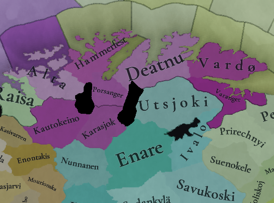
In the colonialism TT we can see two new wastelands that were added to Finnmark, while the northernmost wasteland in the Scandes was removed. Regarding the Finnmark wastelands, I like the idea but I think their positioning is a bit strange. The eastern wasteland covers a part of the Tana river, which, being a river, has many settlements along it. The central winter village of the historical Tenoby siida is located entirely within the wasteland, while the settlement of Karasjok is located on its border:
1729259713886.png

1729259811045.png

I highlighted the Tana river and its branches with blue.

1729260199617.png

Modern settlements are concentrated largely around the Tana river.

It looks like the wastelands were inspired by this post, but on the post the wastelands specifically do not overlap with Tana. I think it would make the most sense to have the wastelands correspond to these mountains, though I'm not exactly sure how much of an obstacle they actually are.
1729257893277.png

1729258893979.png


This would also work perfectly with the next section of this post, which has to do with location borders, but first I want to comment on the wasteland that was removed, by which I refer to this one:
1729257989786.png


I'm not sure if the wasteland should've been removed completely. The change seems to be based on this post by @rapido and, while I don't claim to know better than a person who has actually been there, at least on the map the area looks just as mountainous as the rest of the Scandes. It may be easy to traverse through certain valleys, but that could probably be said about many other parts of the mountain range too. Perhaps part of the wasteland could be preserved, but movement would be allowed through Kilpisjärvi, as shown on the map below. The area nowadays has a road going through it, and the road also corresponds to a river. This crossing also leads directly to Skibotn, so I wouldn't be surprised if this was part of the most popular path from Tornio to Skibotn. It would be great to have rapido's input on this though.
1729258295927.png


Swedish Claims in Finnmark

In the 1751 Treaty of Strömstad, Sweden and Denmark-Norway officially divided Finnmark between themselves. Before the treaty the inner Sámi siidas were disputed and they had to pay taxes to both countries at once. Sweden claimed the whole disputed area for itself and we have maps from the time showcasing the borders that Sweden claimed, such as this. This map from 1905 shows it with more accurate geography. I propose that this border should exist in game, not only because it corresponds well to historical siida borders, but also because Project Caesar is a game that simulates alt history. What if Sweden was able to receive everything that it claimed? Here is a map of how I think this should be done:
1729258251358.png


The map also shows my proposed wasteland changes, and how they would block movement between locations. It also has two new locations I suggest adding: Lappajärvi and Tenoby. Lappajärvi is simply a historical siida in the area that is currently missing, so it's not important to include. Tenoby on the other hand is more important because it fills in the space between my proposed border and the real/modern Finland-Norway border at the Tana river. Historically this sliver of land consisted of the northern parts of the Tenoby and Utsjok siidas. While Tenoby's winter village was situated on the southern coast of the Tana river, it is close enough to the proposed location that this inaccuracy is in my opinion excusable. The borders of the new siidas are based on a map from this Norwegian paper. The map is "Figur 2.2" on page 393. The borders of Porsanger are depicted a bit differently on my map because of feedback given by other people here.

With this setup combined with my earlier suggestions both Sweden and Norway would be able to form borders in Finnmark corresponding to the extent of the pre-Strömstad disputed territory.
1729258729684.png

1729258736083.png


I want to note that the names of Tenoby and Deatnu can be a bit confusing. Both are named after the Tana river (Deatnu in Northern Sámi). The current in-game location of Deatnu matches the modern municipality of Tana, but I've seen Tenoby also being referred to by the name of the river, at least in Finnish sources. Finnish Wikipedia refer to Deatnu on the other hand as "Tenonsuu" (The Mouth of Tana). On a map historical siidas found in this report by Finnmarkskommisjonen (Figur 4.1), the coastal siida (Deatnu) is referred to in Northern Sámi as "Deanodat" while Tenoby is "Deanusiida". However, another map with Sámi names simply calls Tana Deatnu. The best and most accurate way to name the locations would probably be to call Deatnu "Tana" in Norwegian, "Teno" in Finnish and "Deatnu" in Sámi. Tenoby would then be "Tenoby" in Norwegian, "Tenokylä" in Finnish and "Deanusiida" in Sámi.

Names:
NorwegianSwedishFinnishNorthern Sámi
AviovaraAviovaraAviovaaraÁvjovárri
KautokeinoKautokeinoKoutokeinoGuovdageaidnu
Lappajärvi?LappajärviLappojärviLáhpojávri
TenobyTenobyTenokyläDeanusiida

Locations in Kola

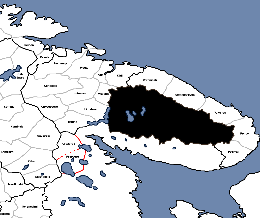
I decided to review the locations in Kola because I hadn't seen anyone give feedback on the area. I found several inaccuracies, mainly locations being placed wrong or having misspelled names. I used various sources, such as the Wikipedia page for Kolsky Uyezd, which has a list of pogosts in 1785, and some Russian language sites to get an idea of the settlements and administrative divisions in the area. Here's my suggestion for how Kola could be made more accurate, with sources and explanations below it:
1729258932188.png


Sources used:
Explanations:
  • I redrew the borders of the locations to be closer to historical siidas/pogosts. The borders of Pechenga (Petzinka) would be especially good to represent, as it was the easternmost siida of the Russo-Norwegian shared area (Fellesdistrikt) before the modern Russo-Norwegian border was drawn. Similar to the border claimed by Sweden in Finnmark, it would've been plausible for Norway to receive the whole Fellesdistrikt for itself, with the border possibly matching Pechenga's eastern border.
  • Relating to Pechenga and Fellesdistrikt, for the sake of immersion I divided the current Varanger location into the historical siidas of Neiden and Pasvik, both part of Fellesdistrikt. Despite Pasvik's territory reaching a bit east of the modern Russia-Norway border, the more recognizable border would probably be better and less confusing. To my knowledge this change shouldn't conflict with any more prominent Norwegian settlements in the area. (From the Steppe TT culture map it looks like the location is already split into two locations, but I don't know what they're called. Neiden and Pasvik would make the most sense to me.)
  • A few locations on the current map have errors in their names. The errors seem to come from this map of Russian Lapland by Thomas Kithen or a similar source, as the names are exactly the same as the in-game map. Molouskoj is very likely a misspelling of Motovskoi (Motka) seen on the source maps while Mafelskoj is likely meant to be Maselskoi (Maselga) (Perhaps the map maker confused the long s with f?). I wasn't able to identify what Lekanstroj on the in-game map is, but from its location in relation to the other locations it probably is meant to be Iekastrov (Ekostrov).
  • I wasn't able to identify Koliskoj, but on the 1745 map it is seen on the coast of a lake called Ozero Kola. It's very close to Kuolajärvi (Kola Lake) on the side of Kemi Lappmark, so perhaps they're the same? As Kuolajärvi should be part of Kemi Lappmark, I replaced Koliskoj in Western Kola with Babino/Akkala based on my sources.
  • I wasn't able to find any mentions of Peszenskoi (even by googling the Cyrillic name and its romanizations), but it can be seen on the source maps. In the maps its placed on the eastern side of the Kola settlement and river, while the current in-game location is too far to the south and west. Because its historical place would overlap with the Kildin location and historical pogost, I think it should simply just not be included.
  • I moved Kola a little bit to the west to work better in a setup based on historical pogost/siida borders.
  • As already pointed out by someone, Prirechny is far too recent, established in 1960. Based on the maps of historical siidas, I moved Suenokele/Songelsk to its place and added Girvasozero in its old place. I made Girvasozero bigger than it was historically to avoid odd-looking borders.
  • Notozero is another new addition based on historical siidas.
  • While I was able to find Dalen Olina and Svetenoes on maps, I'm unsure if they were actual settlements or just geographical names, so I replaced them with historical siidas based on the source maps.

Names in different languages:
RussianNorwegianSwedishFinnishKarelianSámi
Babino/Babensky (Бабинo/Бабенский)Ah´kelAkkalaA´hkél (Akkala Sámi)
Ekostrov/Ekostrovsky (Экостров/Экостровский)JokostrovČu´kksuâl (Akkala Sámi)
Girvasozero (Гирвасозеро)HirvasjärviHirvasjärviSââ´rvesjäu´rr (Akkala Sámi)
Kildin/Kildinsky (Кильдин/Кильдинский)KildinKiltinäKiillt (Kildin Sámi)
Kola (Кола)KolaKolaKuolaKuâlõk (Skolt Sámi)
Maselga/Maselgsky (Масельга/Масельгский)Masel`gaMaaselkäMoašelgä? (Name of a village in Karelia with the exact same name)Maaziell`k (Kildin Sámi)
Motka/Motovsky (Мотка/Мотовский)MuetkeMuotkaMue´tǩǩ (Skolt Sámi)
Notozero/Notozersky (Нотозеро/Нотозерский)NuortijärviNuorttijärviNjuõʹttjäuʹrr (Skolt Sámi)
Nyavdema/Nyavdemsky (Нявдема/Нявдемский)NeidenNäätämöNjauddâm (Skolt Sámi)
Pazreka/Pazretsky (Пазрека/Пазрецкий)PasvikPaatsjokiPaaččjokk (Skolt Sámi)
Pechenga/Pechengsky (Печенга/Печенгский)PeisenPetsamoPeäccam (Skolt Sámi)
Ponoy (Поной)PonojPonojPyönnePɨenne (Ter Sámi)
Pyalitsa (Пялица)
Semiostrovsk/Semiostrovsky (Семиостровск/Семиостровский)Norres (Danish)Nyrr’t (syjjt) (Kildin Sámi)
Songelsk/Songelsky (Сонгельск/Сонгельский)SuenjellSuonikyläSuõʹnnʼjel (Skolt Sámi)
Voroninsk/Voronensky (Воронинск/Вороненский)Koarrdõgk (Kildin Sámi)
Yokanga/Yokangsky (Йоканьга/Йоканьгский)JokangaJofkjogk (Ter Sámi)

I also readjusted the borders of the provinces a little to correspond with a way the Kola Sámi were historically divided. Current Western Kola corresponds almost perfectly to the territory of the Konchanskaya Lapps, while North Kola corresponds to the Terskaya Lapps. Southern Kola works well to represent the Russian pogosts.

I also have a suggestion for locations in the northernmost part of the old Karelian wasteland. I've seen some suggestions for it by other people, such as extending Alakurtti to encompass some of the area. I however found some information about the historical Sámi settlements in the area. On the Wikipedia page for the historical Kolsky Uyezd, a place called Pyaozersky is mentioned as one of its pogosts. This corresponds to the lake Pyaozero in White Karelia. saami.su lists several siidas in the area, but only two of them were mentioned after 1607-1611, these being Pyaozersky (Пяозерский) and Orezersky (Орезерский). On this map the same siidas can be seen under the North Sámi names Oaivejávri and Orešjávri. (Also known as Bejauri and Orejauri in supposedly another Sámi language. I found these names from the paper Saamelainen asutus karjalassa.) I think these would be better than Alakurtti for two reasons: First, Alakurtti was historically part of Kuolajärvi on the Swedish side, so it wasn't even an independent parish or part of Russia. Second, it was a newer colonial settlement compared to the older Sámi settlements. Here's a sketch of the locations on a map that also includes my older suggestions (Alakurtti doesn't appear at all due to being part of Kuolajärvi. Also, Orezero has a question mark because its so obscure that I wasn't even able to find Finnish/Karelian names for it):
1729258954264.png


Names:
RussianFinnishKarelianSámi
Orezero/Orezersky (Орезеро/Орезерский)Orešjávri/Orejauri (North Sámi/?)
Pyaozero/Pyaozersky (Пяозеро/Пяозерский)PääjärviPiäjärviOaivejávri/Bejauri (North Sámi/?)

The names Orejauri and Bejauri are also used in this Swedish language source from 1828: Anteckningar om församlingarne i Kemi-lappmark af And. Joh. Sjögren. Maybe they could be the names in Swedish/Norwegian/Danish?

White Sea Salt Production

One major thing I discovered that is not currently represented on the map is the important salt production industry on the coast of the White Sea in Karelia. According to Karjalan kansan historia (Heikki Kirkinen, 1995), salt production became a major industry in the area in the 16th century, and became the largest source of wealth in the region. The salt was produced from sea water by boiling it inside large salt kettles. A salt brewery was known as a "varnitsa" to the Karelians and the word comes from Russian Варница. Varnitsas were most common in the area between Unezhma and Kem, but were also used a lot between Keret, Kovda, Kandalaksha and on the southern coast of Kola. At the peak of the industry, the Karelians had around 180 varnitsas and produced around 18 000 tonnes of salt per year. The German traveller Sigismund von Herberstein described how every winter the salt was brought to Novgorod using 2 000 horses.

Based on this, some coastal locations on White Karelia and Southern Kola should have salt as a raw material. I don't really know what the best way for determining the salt locations would be, but if we go by the density of varnitsas, the following map could be useful:
1729280483078.png

Saltworks on the coast of Dvina Bay at the end of the 16th century. From Karjala idän ja lännen välissä (Heikki Kirkkinen, 1970).
- Black dots: Varnitsa in use
- White dots: Unused varnitsa

The biggest singular concentration of varnitsas was in Keret (Fin. Kieretti), but the southern coast had more in total. The village of Porjalahti stands out too. Depending on balance there could be more or less salt locations.

Salt production required a lot of iron, as the salt kettles had to be replaced annually. While Russia had many large centers of iron production, most of the iron was used by the core areas of Russia. Instead they used local Karelian iron. In Karjala idän ja lännen välissä Kirkkinen mentiones many places that were a source of iron, such as Aunus (Olonets), Suoju (Shuya), Kiisi, Megra, Vaasena (Vazhiny) and Oshta. However, the village of Sunku (Shunga) is mentioned as one of the most important sources of iron (and coal) in Karelia. In Karjalan kansan historia Kirkkinen says that the Zaonezhye peninsula, which Shunga is a part of, was an abundant source of iron. In the 17th century many large Russian, German and Dutch owned smelting plants were built on the peninsula. Based on this, perhaps it would make sense for Shunga (or the in-game location corresponding to it) to have iron as a raw material.

Useful Resources

The paper Words and Varieties. Lexical Variation in Saami has a section and the end listing the names of various places in Finnmark, Lapland and Kola in Swedish, Norwegian and the local Sámi languages.

I also want the mention this report by Finnmarkskommisjonen again. Figur 4.1 shows a map of historical siidas in Norway with Northern Sámi names. The siidas don't seem to completely match the siidas in other maps though, probably because they were different at different times.
 
Last edited:
  • 8
  • 4Like
  • 4Love
Reactions:
The Wastelands in Northern Scandinavia

View attachment 1203684

I'm not sure if the wasteland should've been removed completely. The change seems to be based on this post by @rapido and, while I don't claim to know better than a person who has actually been there, at least on the map the area looks just as mountainous as the rest of the Scandes. It may be easy to traverse through certain valleys, but that could probably be said about many other parts of the mountain range too. Perhaps part of the wasteland could be preserved, but movement would be allowed through Kilpisjärvi, as shown on the map below. The area nowadays has a road going through it, and the road also corresponds to a river. This crossing also leads directly to Skibotn, so I wouldn't be surprised if this was part of the most popular path from Tornio to Skibotn. It would be great to have rapido's input on this though.
View attachment 1203690

I generally agree with your wasteland points here.

I am originally from the Tromso area, and while Rapido was techncially correct on the history, it still feels super weird that Northern Norway is so geographically exposed. Applying a standard of (a) "could an army realistically march through this area," and (b) could a state maintain standard administrative control across this terrain, I'd argue that the areas should probably have remained wasteland (except maybe a narrow corridor?).

It is technically possible to traverse the area on foot... in the same way that it is to cross the Himalayas, deserts, or other areas that Tinto Maps classify as "wasteland." In the summer, the area was incredibly marshy, and in the winter, you really need sleds/skis to move large quantities of people. Until industrial mechanization, I think it pretty inconceivable that a state could effectively move an army through these areas.

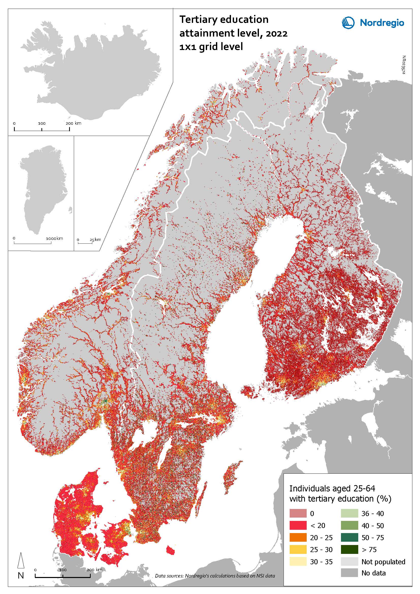
Regarding wasteland placement, I feel a better angle would be to simply rely on modern population heat maps to indicate which areas aren't really traversable. For example, the gray areas here probably do a decent job of indicating which areas you could label as "wasteland":

High-level-education_2023_grid-scaled-1.jpg
 
  • 5
Reactions:
That depends on the depth of the lake.
Not really. Oceans can have huge waves and strong storms which lakes can never have. Also, logistically speaking on a lake you are never as far away from land as on ocean. I can see coastal ships (like galleys in eu4) being able to access lakes though.
It doesn't sound terribly complicated.
I didn’t say it was?
I'd hardly call the 33rd largest lake in the world "tiny." They already depict the Caspian divided into numerous locations, and there's literally a naval terrain code named Inland_sea. At which point between Saimaa and the Caspian does "tiny" begin in your estimation?
Tiny as in 1-3 locations in size. Which Saimaa pretty much is. The comparison to the Caspian is strange as the Caspian is not a lake, but an inland sea. The Caspain has a surface area of 371,000 km2 and average depth of 211 m compared to Saimaa’s 4,279 km2 and 17 m. It makes perfect sense to make the Caspian navigable. Can’t say the same for Lake Saimaa. Lake Ladoga, the largest lake in Europe, is a bit more reasonable, but as the devs have said no to navigable rivers, the option of linking the lake to the Gulf of Finland via the Neva is not available. Thus it too would only be about 4-6 more locations in size, and not really worth it to be navigable in my opinion. As an example of lakes that could be navigable, the Great Lakes in the Americas are probably the best example. Surface area is 244,106 km2 and average depth is 18–146 m which is pretty close to the Caspian Sea.
More to the point, what you do with these locations is entirely up to you. Major lakes that aren't on the border of hostile power are very unlikely to see any naval action, and as for those that are, you're not being forced to build ships there any more than you're being forced to make any other military decision. Right now you're complaining about the player being allowed to do something. These aren't "issues," these are options, something you'd think the player would want more of. "I was looking forward to doing my own version of the War of 1812, but I was put off when I found out I could deploy a fleet on Lake Erie," said no one ever. "They shouldn't have added that mountain pass, cause if you build a fort there it can only be attacked from 2 directions," as famously stated by the same people. "Naval terrain that can freeze over during winter shouldn't be a feature because it's an extra thing to consider when allocating military resources," is another famous complaint we hear from this crowd.
I’m complaining? Not really. At this point your post devolves into a weird strawman argument so I won’t bother writing anything else about this section.
 
  • 6
  • 1
Reactions:
Not really. Oceans can have huge waves and strong storms which lakes can never have. Also, logistically speaking on a lake you are never as far away from land as on ocean. I can see coastal ships (like galleys in eu4) being able to access lakes though.

I didn’t say it was?

Tiny as in 1-3 locations in size. Which Saimaa pretty much is. The comparison to the Caspian is strange as the Caspian is not a lake, but an inland sea. The Caspain has a surface area of 371,000 km2 and average depth of 211 m compared to Saimaa’s 4,279 km2 and 17 m. It makes perfect sense to make the Caspian navigable. Can’t say the same for Lake Saimaa. Lake Ladoga, the largest lake in Europe, is a bit more reasonable, but as the devs have said no to navigable rivers, the option of linking the lake to the Gulf of Finland via the Neva is not available. Thus it too would only be about 4-6 more locations in size, and not really worth it to be navigable in my opinion. As an example of lakes that could be navigable, the Great Lakes in the Americas are probably the best example. Surface area is 244,106 km2 and average depth is 18–146 m which is pretty close to the Caspian Sea.

I’m complaining? Not really. At this point your post devolves into a weird strawman argument so I won’t bother writing anything else about this section.
To characterize a reductio ad absurdum as a strawman argument is an act of intellectual cannibalism.

If you think the Caspian Sea isn't a lake; if you'd rather play word games than engage with counterarguments; if you're going to pretend that you can't tell the difference between "these are some unfortunate and unforeseen consequences of the principle that you invoked" and "these are some things I've decided out of the blue that you believe"; and if you need to invent moral victories for yourself to bail out on conversations that aren't going your way; then I look forward to no longer reading any replies from you.
 
Not really. Oceans can have huge waves and strong storms which lakes can never have. Also, logistically speaking on a lake you are never as far away from land as on ocean. I can see coastal ships (like galleys in eu4) being able to access lakes though.
Some lakes can have quite large waves and storms, but Samaiaa is indeed not one of those in any reasonable sense. Lake Ladoga or the Great Lakes likely are different. So this is not a good argument. Saimaa also is not that deep in many places (as can be seen from the numerous islands), which makes navigation more difficult when using larger ships.

To characterize a reductio ad absurdum as a strawman argument is an act of intellectual cannibalism.

If you think the Caspian Sea isn't a lake; if you'd rather play word games than engage with counterarguments; if you're going to pretend that you can't tell the difference between "these are some unfortunate and unforeseen consequences of the principle that you invoked" and "these are some things I've decided out of the blue that you believe"; and if you need to invent moral victories for yourself to bail out on conversations that aren't going your way; then I look forward to no longer reading any replies from you.
The Caspian Sea isn't just named that, it is considered a sea by multiple languages / definitions. Hower, that also was the case for the Aral Sea at some point.. Yet, the size difference is extreme. Samaiaa is hardly bordering more than two land locations and quite narrow in many places.
That some lakes are navigable doesn't mean that all of them make sense to be included.
To give a rough answer to your question about where to put the border, maybe take a lake that definitely covers more than one typical sea zone and where transport by ship definitely would be better than over land. Being permanent is also helpful (not like Lake Chad).
The Great Lakes are a viable example, though in game, the Lakes Erie and Ontario potentially are of questionable use (unless Erie is connected to the larger group). In Europe, the Lakes Ladoga and Onega are similar, potentially large enough for 3-4 sea locations, but not really impactful. Lake Baikal could be navigable, but again have negligible impact. Similarly, Lake Malawi or Lake Tanganjika. The big Swedish lakes are similar to Saimaa, and mostly interesting for providing transport/control..

Would you build a navy on the smaller lakes? Any military action in the area will happen on land anyway, as the lake does not block any route. The AI will potentially consider building a useless navy there, which is something we would want to avoid.
 
  • 2Like
  • 1
  • 1
Reactions: