• We have updated our Community Code of Conduct. Please read through the new rules for the forum that are an integral part of Paradox Interactive’s User Agreement.

Tinto Maps #12 - 26th of July 2024 - Germany

Hello, and welcome to another new Tinto Maps! I’m back to duty, after the review of Italy that we posted last Thursday, and Johan taking care of Scandinavia last Friday. Today we will be taking a look at Germany! This region comprises the modern territories of Czechia, Austria, Switzerland, and Liechtenstein. However, for most of the timeline in Project Caesar, it was better known as the Holy Roman Empire. This organization once was a feudal empire elevated from the Kingdom of the Germans, but by 1337 was mostly disaggregated into a multitude of temporal and ecclesiastical jurisdictions, with only a tenuous feudal relationship with their Emperor.

Let’s start diving deep into this nightmare, then…

Countries:
Countries.png

I’m showing here a bit more of what the region is, so you can have a clear depiction of how it looks compared to the neighboring regions we’ve previously shown (and so that the Reddit guy who is patchworking the world map has an easier day ). What I can say about this when the map speaks for itself… The lands of Germany are highly fractured among different principalities, making for an extremely complex political situation. The Emperor in 1337 was Louis IV von Wittelsbach of Upper Bavaria… Because, yes, Bavaria is also divided. He is married to Margaret of Avesnes, daughter of Count William of Hainaut, Holland, and Zeleand, while his son Louis is the Margrave of Brandenburg. But probably the strongest power of the period is the Kingdom of Bohemia, whose king John also Duke Luxembourg and rules over both lands in a personal union, while also being overlord of the Margraviate of Moravia, ruler by his son Charles, and the Silesian principalities. The third contender probably is the Duchy of Austria, ruled by Albert II von Habsburg. He also rules over some lands in the formed Duchies of Swabia and Carinthia. There are also plenty of medium and small countries all over the region, with very different forms of government, which will probably make this HRE a very replayable experience…

Dynasties:
Dynasties.png

The dynastical map of the HRE gives a nice picture of the situation explained in the previous one. The von Wittelsbach, de Luxembourg (John of Bohemia is considered of French culture, therefore it uses the French toponymic article ‘de’; if he would change to the German culture, then it would be the ‘von Luxembourg’ dynasty), and von Habsburg cover much of the map; you may note that the Wittelsbach rule over five different countries (Upper Bavaria, Lower Bavaria, the Palatinate of the Rhine, and Brandenburg); while the House of Luxembourg also control the Archbishopric of Trier through Balduin, uncle of King John. Other important dynasties, although in a secondary position, are the Welfen, von Mecklenburg, and Gryf, present in multiple countries to the north; the Askanier, who happen to control half of Upper Saxony, while the rest is in the hands of the von Wettin; and the von Görz, who rule over the Duchy of Tirol and the County of Gorizia.

HRE:
HRE.png

We obviously have to repost the HRE IO map again here. The purple stripes mark the imperial territory, while the different types of members use different colors. We currently have these divisions in the IO: the Emperor (1, dark blue), Prince-Electors (4, light blue), Archbishop-Electors (3, medium blue), Free Imperial Cities (23, light green), Imperial Peasant Republics (2, orange), Imperial Prelates (44, white), and Regular Members (280, dark green). So, yeah, that make for a total of 357 countries that are part of the HRE. And before you ask: No, we won’t talk about its mechanics today, that will happen in future Tinto Talks.

Locations:
Locations.png

Locations 2.png

Locations 3.png

Locations 4.png

Locations 5.png
Germany has the highest density of locations in the world, as we wanted to portray the historical fragmentation of the HRE at the most detailed level of any Paradox GSG. There are a couple of things that we are aware of and we want to rework: the location connections (as in some places they are not obvious at all, and we want to make warfare in the HRE not impossible); and the transition between the German locations and those at their east, making it smoother (something that we will be doing in the review of Poland, Hungary and this region [e.g. for Bohemia]). A final comment: if you click on the spoiler button, you may be able to see 4 more detailed maps of the region.

Provinces:
Provinces.png

Map of provinces. As usual, suggestions are welcomed.

Areas:
Areas.png

Areas. We are currently not happy with the area borders (or at least, one of our German content designers isn't, and let me note it while preparing the DD... ;) ), as they reflect more modern areas so we will be looking into an alternative setup for them with your feedback. They also currently use their German names, which will change to English ones to be in line with other areas, as usual.

Terrain:
Climate.png

Topography.png

Vegetation.png

Terrain mapmodes. The region is quite forested, in comparison to other parts of Europe.

Culture:
Cultures.png

Let’s open the Pandora box and take a look at the cultures! The German cultures have come through a couple of reworks, until we’ve found a spot in which we’re kind of happy (or, at least, our German content designers do not complain!). The German cultures are very linguistically related, as we thought that it would be the best starting point for 1337. Please let us know about your thoughts on them.

Religion:
Religion.png

Boring religion map this week, as the region is overwhelmingly Catholic. There are Ashkenazi Jews in a bunch of places (a quick account: they’re present in 204 locations all over Central and Eastern Europe), and you may also see the Waldesians we added in the review of Italy last week.

Raw Materials:
Raw materials.png

Raw materials! Plenty of!

Markets:
Markets.png

The main market centers of the region are Cologne, Lúbeck, and Prague. We have reviewed them a couple of times, and this is the configuration that makes for a good setup historical and gameplay-wise. And you may also see Bruges, which has been reinstated as the main market of the Low Countries, after some tweaks.

Country and Location Population:
Population.png

Population 2.png

Population 3.png

Populations 4.png
The population of the HRE is… Fragmented. In that regard, Bohemia starts in a very strong position, with a strong competitor to its south (Austria) and north (Brandenburg).

And that’s it for today! I hope that we didn’t drive you into madness with this map… Next week we will take to a very different region, the Maghreb! See you then!
 
  • 175Love
  • 121Like
  • 4Haha
  • 4
  • 3
  • 2
Reactions:
After seeing 200000 German states, I hope to see all the Iberian microstates of Andorra and Couto Mixto!
They were both existing before and during the entire period of EU4 and both have pretty unique government systems
 
  • 1Like
Reactions:
I agree with your redrawing of the Provinces of Mark Brandenburg. But one thing I have addressed in my post about Brandenburg: Markish and Brandenburgish are not synonymous. One refers to linguistic-historical characteristics (Markish) whereas the other one refers to geographical ones (Brandenburgish). The question I raised was therefore what is it supposed to represent? If it's linguistic affiliation (dialect group), then there is a difference between the Berlin / Southern Brandenburg dialect and Markish because Brandenburgish belongs to the Middle German dialects whereas Markish belongs to the Lower German dialects (source). The maps you posted show precisely that, Berlin and Southern Brandenburg are not included in the Lower German dialects.
True but that map is far too modern and shows modern dialects not historical ones, other maps i shared do show older dialect continuums. I used to have some maps somewhere showing the exact line moving north.

I agree though that I was somewhat confused about why they chose both names and how mixed up it all is that it is hard to say what exactly it is showing.

Though Märkish is a dialect that has a broader term than just brandenburg, it mostly overlaps. The issue is like you said South Märkish and North Märkish. But again that's a modern distinction, it's hard to judge what the ones were back in the day.
 
  • 2Like
  • 1
Reactions:
True but that map is far too modern and shows modern dialects not historical ones, other maps i shared do show older dialect continuums. I used to have some maps somewhere showing the exact line moving north.

I agree though that I was somewhat confused about why they chose both names and how mixed up it all is that it is hard to say what exactly it is showing.

Though Märkish is a dialect that has a broader term than just brandenburg, it mostly overlaps. The issue is like you said South Märkish and North Märkish. But again that's a modern distinction, it's hard to judge what the ones were back in the day.
I was confused about that, too. But I learned the differences when reading the Wikipedia article. One difference is, e.g.
  • märk. up ‚auf‘, bln. uff
You would never say "Mak mal up" when speaking Berlin dialect. Apparently, the Berlin / Brandenburgish dialect only developed in the 15th century which is why I suggested to just use Markish instead of having this division (with the option to introduce Brandenburgish later maybe).
 
  • 4Like
Reactions:
Will it be possible when let’s say, playing as Poland, to obtain border based on Odra river? I know that it wasn’t based on it at the time when the game starts, but it was before and much later. It was even Russian Empire’s idea to have a border on that river.
 
  • 1
Reactions:
After seeing 200000 German states, I hope to see all the Iberian microstates of Andorra and Couto Mixto!
They were both existing before and during the entire period of EU4 and both have pretty unique government systems

If you look for the Iberian thread, Andorra is in, but Couto Mixto was considered too small. But there were a lot of requests for it, so I don't know how it might come out in revision (unless the Iberia revision thread has been posted and I missed it).
 
  • 1Like
Reactions:
I'd definitely keep Holstein and Schleswig seperate as one was in the HRE and one was kinda out of it.

I also think lausitz/lusatia could make for a good way to split up Brandenburg being so huge.View attachment 1168858
I like that idea. It seems a lot more natural then the Sachsen-Anhalt approach, and would make for an interesting smaller area with pops of a bunch of different cultures.
 
  • 1Like
Reactions:
I'll have to agree with your German content designers, those areas need a bit of rework.

I went ahead and worked out an (actually two) alternative version to provide some input, and also visualised it to get a better sense of what that alternative map could look like. The names that are spelled out are the areas where something changed. Regarding my reasoning:

  • North Rhine-Westphalia is a very modern construct. The two provinces started to develop increasingly close economic ties during the 19th century, and the idea of those areas being united only came up after WWII under foreign (British) occupation, and for purely economic reasons.
    • A unified Rhineland (consisting of Nieder- and Mittelrhein) could also work in that regard, but I assume that the region is probably too dense for this.
  • The "Mittelrhein" area could include the German-speaking areas of Luxembourg, while the French part would remain largely with Wallonie (except for Thionville, which would go to Lorraine, both for logistical reasons and because it is part of France today). That would nicely underline the cultural diversity found within the country.
    • Alternatively, Luxembourg could also be it's own area if there need to be more, but I figure that it would probably be too small...
  • Since the "Oberrhein" area in the current version consists mostly of locations belonging to the "Kurrheinischer Reichskreis" (including the Electoral Palatinate), I just went ahead and combined in with the Pfalz, since those areas would mostly belong together politically anyways. Mainz and Worms could also be added to it potentially.
    • But you could also just leave the current "Oberrhein" be, and add another independent, small but dense "Pfalz" area, if you wanna leave the Rhine as a boundary. This might even be the better option...

  • Since Schwaben was split into two anyways, I changed the split a little to reflect cultural lines better, and changed it to "Schwaben" and "Baden".
    While "Baden" was, in some capacity, used contemporarily for the area (some of the counties in the area carried it in their name, and where controlled by the house of Baden)
    • Another possible name for it would be "Alemannien" (which was, however, also used synonymously with all of "Swabia" for a long time, but it would still get the idea across and be a bit more neutral).

  • The "Innviertel" of Oberösterreich used to be part of Bavaria until the late 1700s, and only then changed hands.
    Given that it consequently was part of Bavaria for the majority of the game, and that there isn't really a cultural or geographic reason for it to belong to Austria, it would make more sense for it to belong to the Niederbayern area.

  • The borders of Sachsen, Thüringen and Brandenburg should be a bit different.
  • Sachsen (which should probably rather be called "Obersachsen") used to be much bigger (at it's largest extend, it even included Belzig), with a lot of the areas that used to belong to it directly or where part of independent and semi-independent states being part of the Brandenburg-area in the current map (Wittenberg being in the Brandenburg area strikes me as especially weird, given the role that the city and it's connection to the Elector of Saxony played in the Reformation). These areas only came under the influence of Brandenburg after being annexed during the 18th and 19th century, though, and many of them even then remained their own thing as the "Province of Saxony" within the Kingdom of Prussia, much of which became modern-day Sachsen-Anhalt. I roughly oriented myself on said Prussian Province when drawing the new borders.
  • However, there are also areas in the Sachsen area that historically should be part of other areas.
    • Görlitz belonged to Silesia until WW2, only being transferred to Saxony as part of the new Oder-Neiße-border.
    • Altenburg could be assigned to the Thüringen area, as it used to be one of the independent small "Thuringian states", and also is part of Thuringia today
  • I'm not a fan of your Sachsen-Anhalt area, if I'm being honest, since it again feels a little artificial. However, if you keep that one around, at least include the location of Zerbst in it, since it historically belonged to Anhalt.

  • Regarding Northern Germany, there are multiple ways of handling it.
  • First off, Mecklenburg simply isn't part of Pommern.
  • Schleswig-Holstein could act as one large area (with the Danish King trying to gain / increase his control over it), or it could be two different areas ("Schleswig" and "Holstein"). Either way, Hamburg may or may not be part of it (it technically was a vassal of the Danish crown at some point iirc, but it really is more culturally tied to Lower Saxony).
  • The area that is currently labeled "Niedersachsen" (and some parts of the surrounding areas), could simply be split in two along the river Weser, creating two new large areas, "Westfalen" and "Ostfalen".
    • If these areas are two big, parts of them could be split off as a costal "Niedersachsen" area.
      • As Mecklenburg and Holstein used to be part of the "Niedersächsischer Reichskreis" and used to have deep ties with the Hanseatic trade, they could also be part of that area.
        • Given it's Hanseatic history, Hamburg should probably be included in it either way.
      • Besides the areas I have shown on my map, the Oldenburg Province, as well as Celle and everything North of that could also be added.
    • If Westfalen extends too far south, the region around Olpe could be given to (or split between) Niederrhein and Hessen.

  • Finally, I think that it might be more interesting to split of Slovenia into different areas, since that also used to be the case historically (and to some degree to this day). The concept of a unified geographic location called "Slovenia" is relatively new, after all, and wasn't really used before the 19th century.
  • Instead, it would make sense to simply give Maribor and Celje to Styria, since they are part of that region.
    • If that works better, you could also think about making a mostly German "Obersteiermark" and a mostly Slovene "Lower Styria", though the Slovene area would probably need a few more locations than just Celje and Maribor for that to work...
  • Tolmin and Gorizia could be given to the Istria (or in that case, it may be bette to rename it "Litorale") area. Or they could be given to "Veneto and Friuli".
    • In that case, you could maybe even go ahead split "Veneto and Friuli" into, well... "Veneto" and "Friuli".
      • If you go for that option, it may be a good idea to also add Trieste to it, to have a larger city included in the area. But it could also remain with Istria, I can see arguments for both approaches.
  • What remains of "Slovenia" forms the "Carniola" area.

These ideas are, of course, all from a purely cultural / geographic angle, since I obviously can't really consider gameplay balancing for a game that isn't out yet. So there may or may not be very good reasons for the map to be as it currently is.

But still, I hope I could provide you some useful feedback. What you have shown of the game up to know looks great, and maybe you'll find something worth considering among my insane ramblings.
The first one of this I think is by far my favourite of all the area proposals so far. I have a few comments though:

Bruntál and Opava should be part of Silesia.

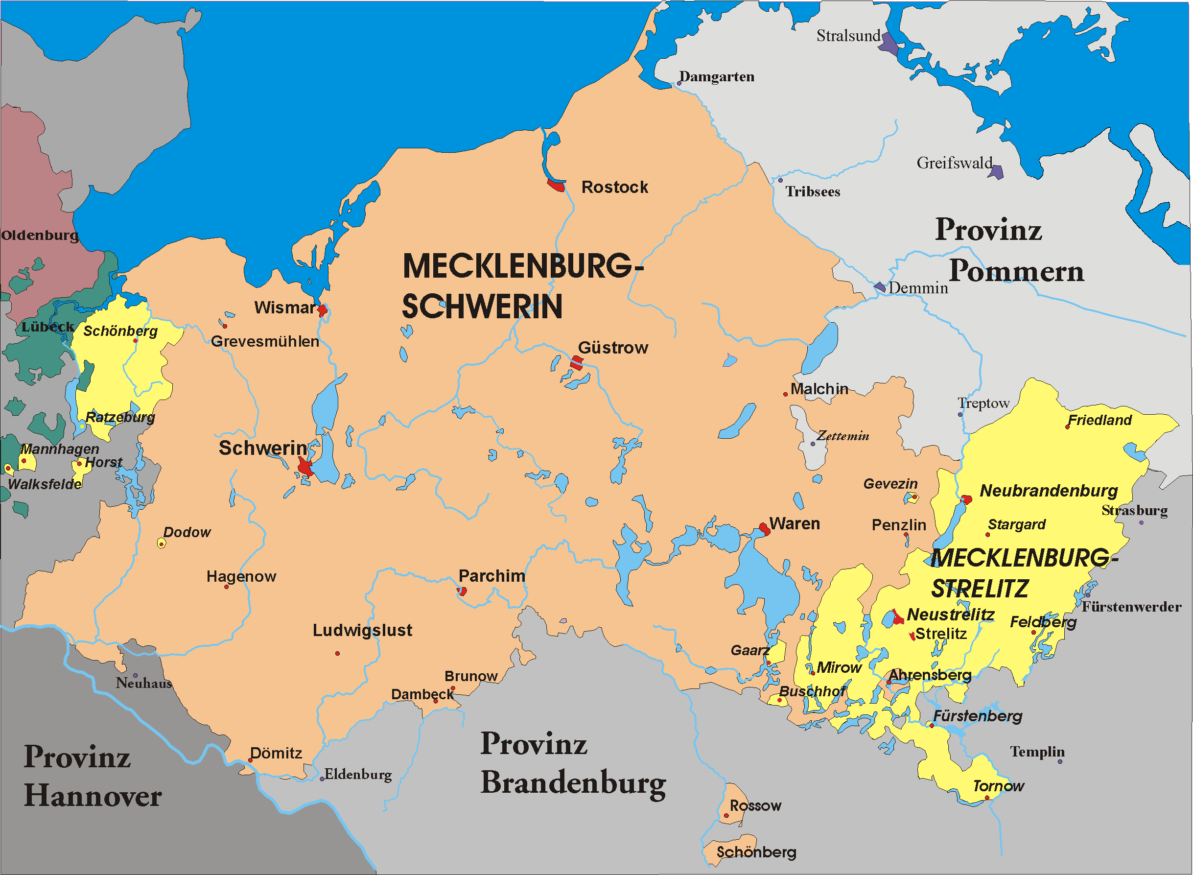
Shouldn't the territory of Mecklenburg-Strelitz be part of Mecklenburg? It was owned by Brandenburg a bit before the game start, but I'm pretty sure it was part of Mecklenburg throughout the whole span of the game, and Mecklenburg is already a small area anyways.

I think Lusatia should be an area rather than being awkwardly split between Silesia, Upper Saxony, and Brandenburg.

Slesvig should probably be its own area, or maybe part of Jutland.

Baden seems a bit anachronistic as a name for that whole region though I'm not sure if there's a better name for it.
 
  • 1Like
Reactions:
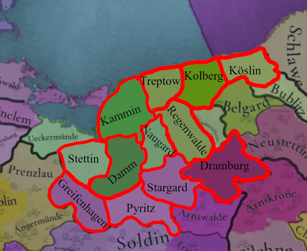
Pomerania feedback

Locations:
Pomeranai provinces feedback.png


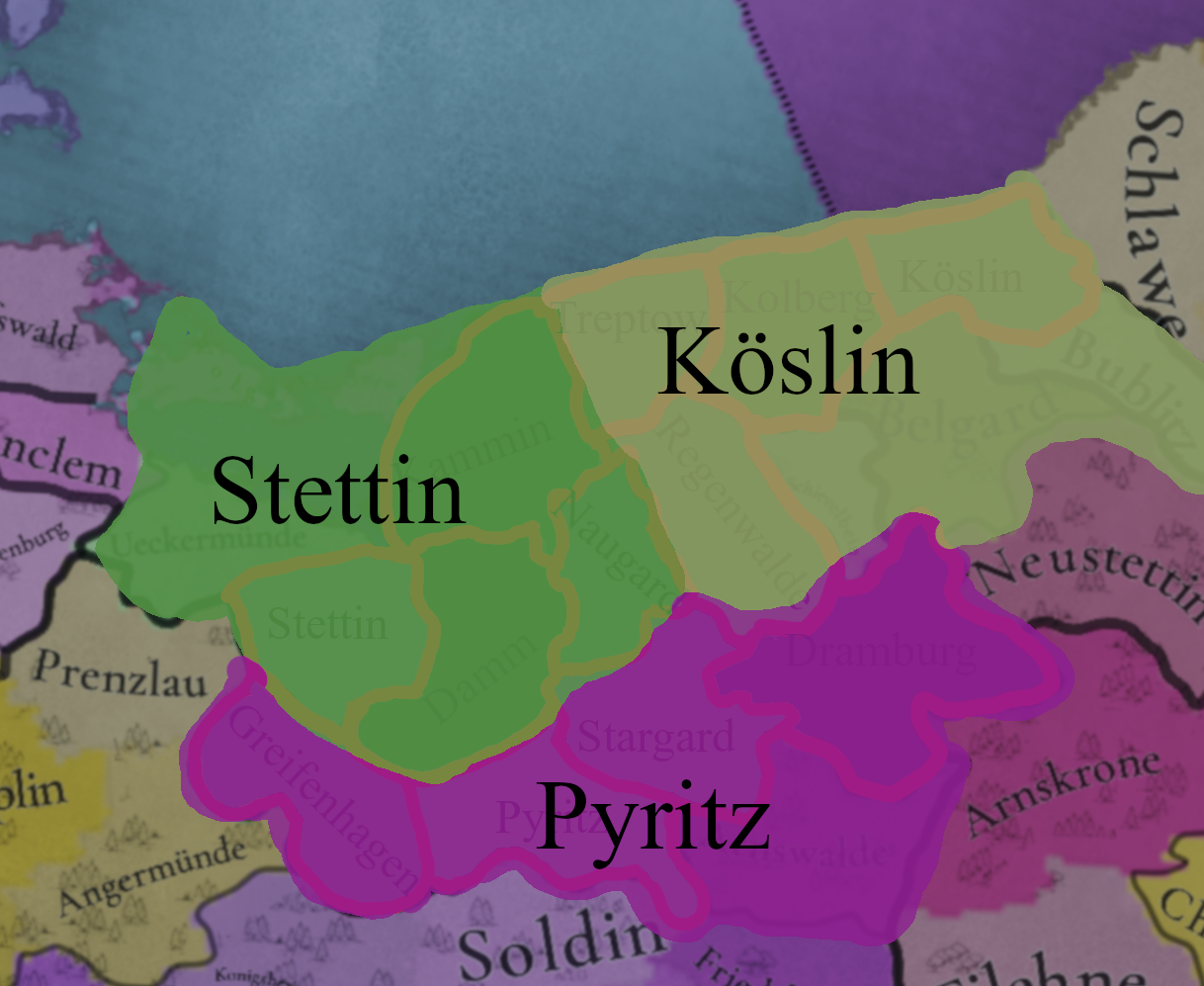
Damm:

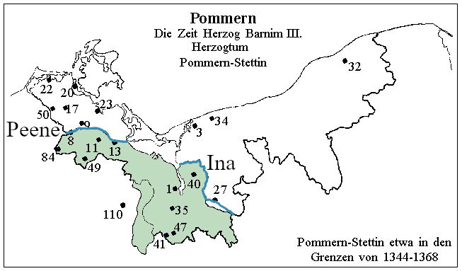
In 1295 the Duchy of Pomerania was divided by the rivers Peene and Ina between the Duchies of Pomerania-Stettin and Pomerania-Wolgast. The border on the Peene River is good, with Anklam and Demmin on the Stettin side.
9783767114_9d7a652919_o.jpg


However, the border on the river Ina is not visible being completely owned by the Naugard location. To show this divide I suggest adding the location of Gollnow or Damm.
Damm (Dam, Damme, Dąbie) got Magdeburg rights in 1260, changed to Lübeck rights in 1293. Gollnow (Goleniów) got Magdeburg rights in 1264 and Lübeck rights in 1314. I chose the former because it is in the center of the province and was the favorite residence of the Stettin Duke Otto I. The border from north and east is the Ina river from west Oder river and Dabie (Damm) Lake and from south the Buchheide (Puszcza Bukowa). Since it was a fishing village, fish should be the trade good there.
karte.jpg


Stargard/Saatzig:
The location should be renamed since Stargard was the most important city and trade cnetre in that area. Saatzig was only used as administrative district in german empire.

Treptow/Greifenberg:
Optional rename, both cities in that location were important trade centers.

Kolberg:
Köslin should be divided into Kolberg and Köslin, since they were the 2 most important cities in the bishopric of Cammin. The bishops had their residence in Kolberg and the administration of the diocese was done from Köslin. Kolberg had two salt pans, which were used for mining and later for trade, so the trade good should be salt there. (Jörg Jarnut, Peter Johanek, Die Frühgeschichte der europäischen Stadt im 11. Jahrhundert, Köln-Weimar-Wien 1998, pp.273–305)


The county of Naugard:

Grafschaft Lippe & Grafschaft Naugard-Massow.jpg


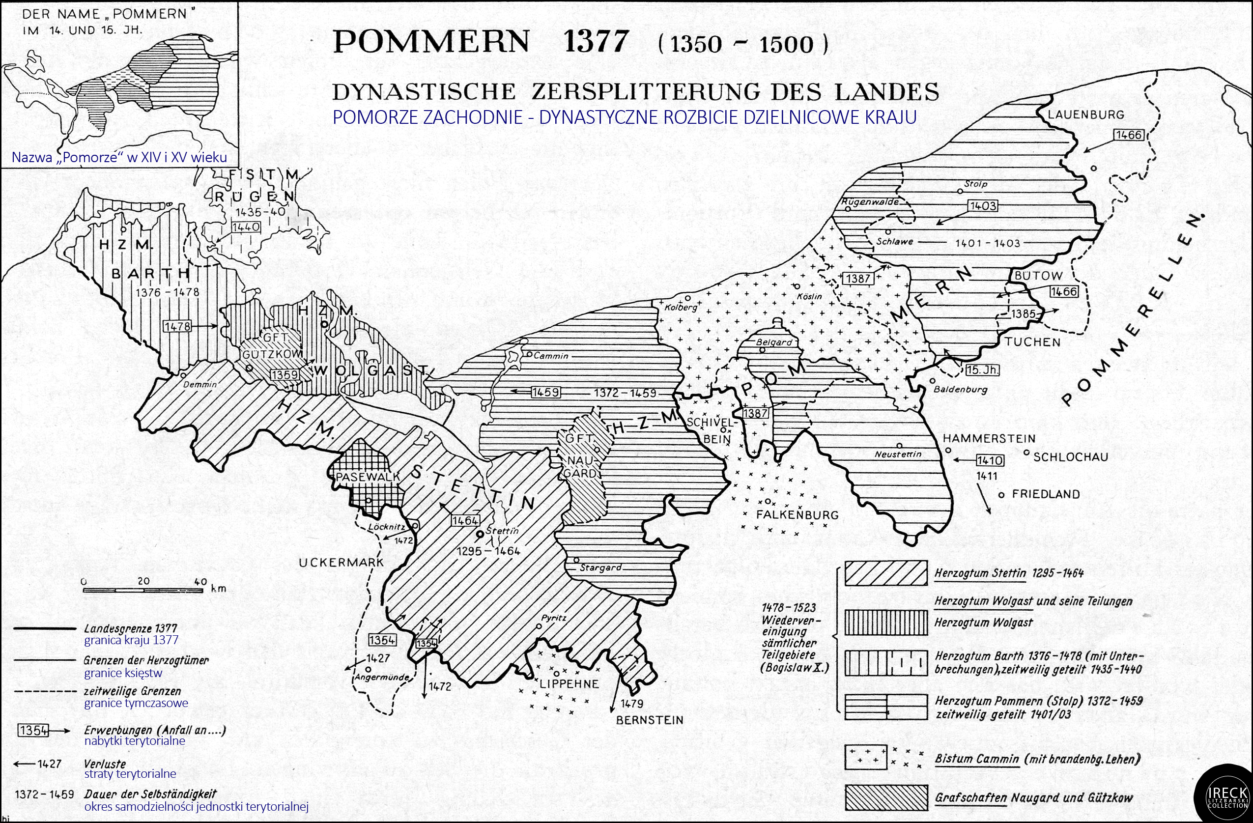
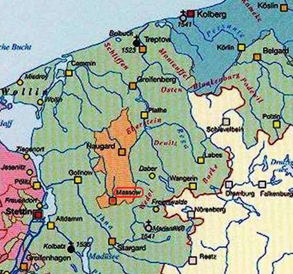
Since your inclusion of Regenwalde (Resko) as an independent tag ruled by the von Borcke family, it is hard not to include the "County of Naugard" in the location of Naugard. It was ruled by the Eberstein family from XIII to XVII century. The county is also visible on the Pommern 1377 map higher in this post (Grafschaft Naugard). Gustav Kratz: Die Städte der Provinz Pommern 263-298.


Provinces:
pomeranian provinces re.png

Stettin: added Wolgast, if you wanted to go to the port of Stettin you had to go through these islands. Remove Greifenhagen
Pyritz: Add Greifenhagen, since it is on the western edge of the Pyritz Plain (Równina Pyrzycka). And for balance (6 locations in Stettin, 5 in Pyritz and 7 in Köslin).


Areas:
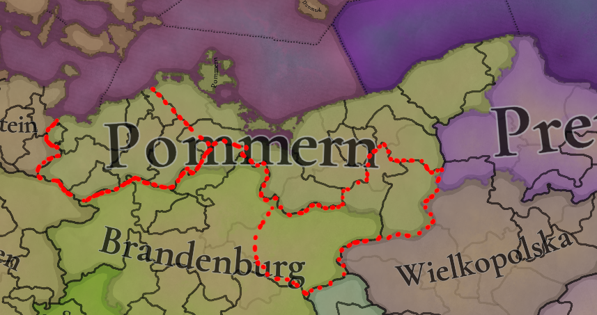
provinces re.png

This region should be split into 3 part:
Mekclenburg
Pomerania (let's use the English name)
Neumark

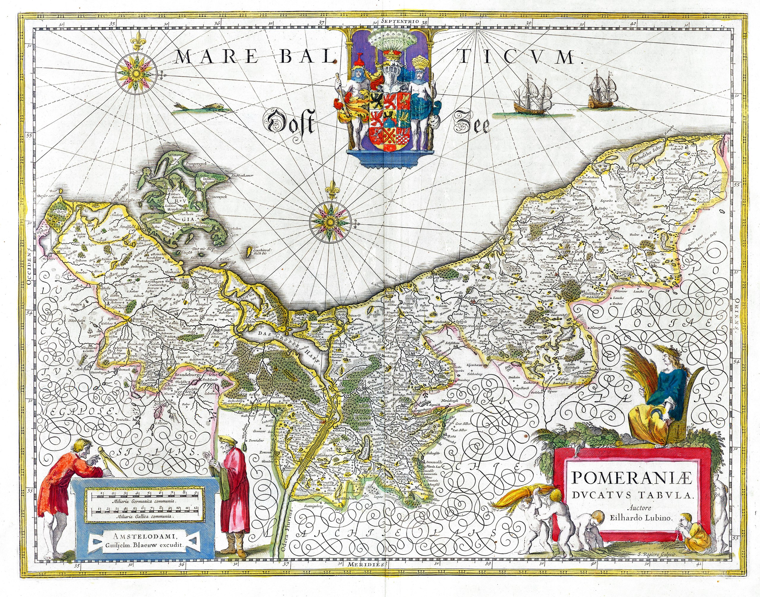
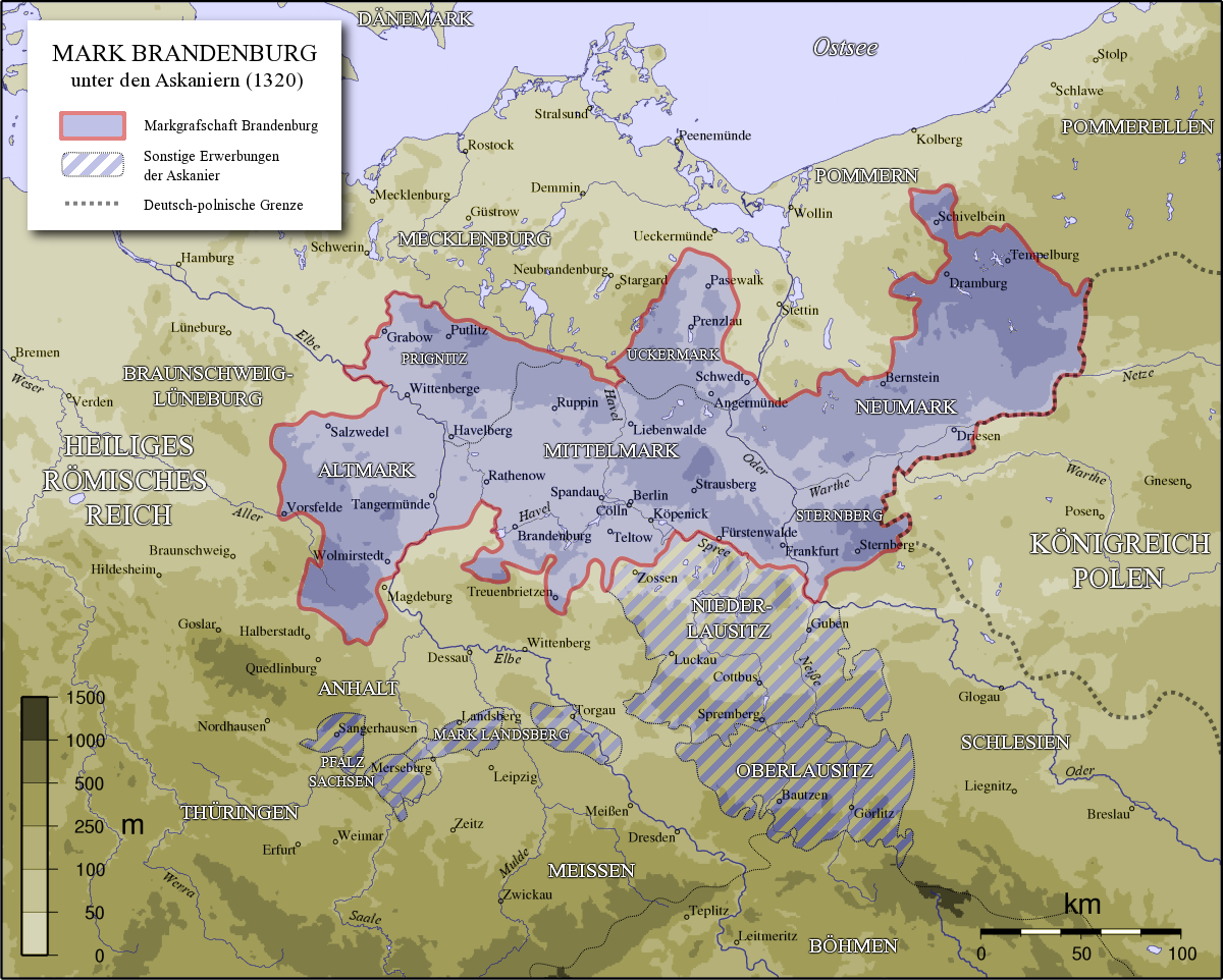
The borders I drew here are not precise, here are the individual maps of the areas:
Pomerania:

Pomeraniae_Ducatus_Tabula.jpg


Neumark (with inclusion of Sternberg with the western border on the Oder River):
MarkBrandenburg.png


Mecklenburg:
Karte-Mecklenburg.png


Thank you very much i wish you a pleasant day.

P.S. I think Markish and Brandeburgian shouldn't be separate, Western Pomeranian should be renamed to Mecklenburgian and Eastern Pomeranian to Pomeranian.
 
Last edited:
  • 7Like
  • 4Love
  • 3
Reactions:
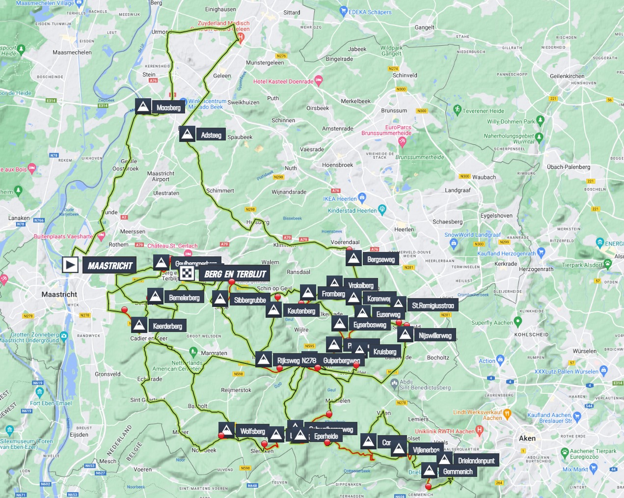
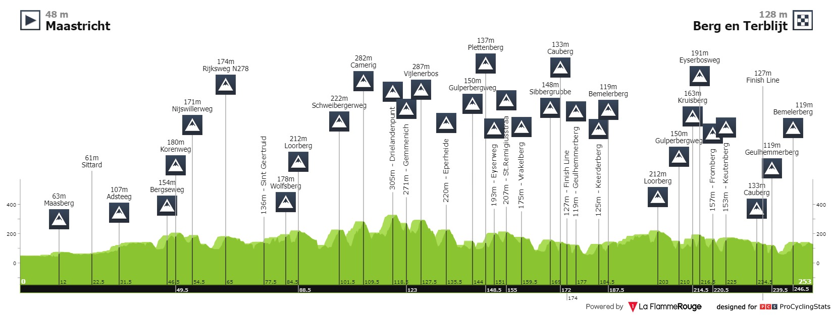
This year's Amstel Gold Race had 3290 vertical meters:
amstel-gold-race-2024-result-map-7c57dd084b.jpg
amstel-gold-race-2024-result-profile-6df15d2321.jpg
This basically covers most of the Maastricht location in the game. Not big hills, but a lot of them. That's why making Maastricht hilly came up several times in the Low Countries threads.
But anyway, that's not really something for the Germany thread.
You're kidding, right :D
Notice how the majority of those elevations are closer to Aachen than to Maastricht, and would be part of tha location in game.
If there was a rolling hills terrain in game, I would grand it that, but not hilly, really just no. Compared to the rest of the Netherlands maybe but compared to the rest of the world, no.
 
  • 2
  • 1Like
Reactions:
The first one of this I think is by far my favourite of all the area proposals so far. I have a few comments though:

Bruntál and Opava should be part of Silesia.

Shouldn't the territory of Mecklenburg-Strelitz be part of Mecklenburg? It was owned by Brandenburg a bit before the game start, but I'm pretty sure it was part of Mecklenburg throughout the whole span of the game, and Mecklenburg is already a small area anyways.

I think Lusatia should be an area rather than being awkwardly split between Silesia, Upper Saxony, and Brandenburg.

Slesvig should probably be its own area, or maybe part of Jutland.

Baden seems a bit anachronistic as a name for that whole region though I'm not sure if there's a better name for it.
Btw, Bruntál should be owned by the Dukes of Troppau (Opava, illegitimate Přemyslid dynasty), thus shouldn't be part of Charles IV's Moravia.

I think that their geographical division of Swabia is actually the best variant (obviously you could also split it into north - south) but there really was no unifying term. Otherwise you might need to split Swabia into three instead of two.
 
  • 4Like
Reactions:
You're kidding, right :D
Notice how the majority of those elevations are closer to Aachen than to Maastricht, and would be part of tha location in game.
If there was a rolling hills terrain in game, I would grand it that, but not hilly, really just no. Compared to the rest of the Netherlands maybe but compared to the rest of the world, no.
(Almost) the entire race happens in the Netherlands, so would certainly not be part of the Aachen location. The eastern and southern borders of the Maastricht location are also the border between the Netherlands, Germany and Belgium.
 
  • 1Like
Reactions:
(Almost) the entire race happens in the Netherlands, so would certainly not be part of the Aachen location. The eastern and southern borders of the Maastricht location are also the border between the Netherlands, Germany and Belgium.
I like how you chose not to argue with the second part of my statement. I take that we are in agreement there, no? :)

Edit: unfortunaly we dont see where excactly the rivers and cities are on the provided map but I believe the locations in game are a bit differnt shaped than the current borders.
 
Last edited:
  • 1Like
Reactions:
I like how you chose not to argue with the second part of my statement. I take that we are in agreement there, no? :)
No, because I already wrote my position in the post that you quoted: While the hills in the Maastricht locations aren't very tall in absolute terms, it's still very undulating terrain, which is why several people suggested hills for the location in the Low Countries threads.
 
  • 1Like
Reactions:
No, because I already wrote my position in the post that you quoted: While the hills in the Maastricht locations aren't very tall in absolute terms, it's still very undulating terrain, which is why several people suggested hills for the location in the Low Countries threads.
then we agree to disagree on that one location. May the dutch have their "hills"! :D

I believe they should change the other locations as I suggested though, namely
Remscheid and Altena to hills (you know actually hilly terrain, check it out for reference)
and
Rourmond, Heinsberg, Bergheim and maybe Düren to flatland instead of hills.
 
Last edited:
  • 1Like
Reactions:
Some points on Lorraine and some surrounding regions :
- The county of Saarwerden didn't belong to Nassau in 1337. They only inherited the title in 1527. According to some sources from the french wiki, the counts of Saarwerden were vassals of the Bishops of Metz until the end of the 14th century (Notice de la Lorraine : qui comprend les duchés de Bar et de Luxembourg etc., 2e édition, Lunéville, Mme George, 1840 (1re éd. 1756), from the french wiki of the county of Saarwerden)
- Also the city of Metz didn't really belong to the bishop of Metz in 1337 since it became an independant republic in 1189. The bishops even lived in Vic-sur-Seille instead of Metz from 1234. I know it can be a bit repetitive to have two country named Metz, but it is already the case for Riga so I think it shouldn't be a problem. The republic of Metz even was in a complicated war some decades before teh start of the game (Guerre des Quatre Seigneurs on the french wiki since it has more information, but there are also a english and a german page)
- I think Strasbourg is in the same situation than Metz (a free city and a bishop living outside the city) but I am less knowledgable about them.
- The county of Bitche also seemed to have been indpendant at the start of the game. It was in a personal union with Zweibrücken until 1333 but the county broke into two parts with Zweibrücken-Bitsch on one side and independant (garman wiki of the county of Zweibrücken-Bitsch has more info) . It wasn't under Lorraine's hand since the end of the 13th century (1297).
- Since you already have Saarwerden as a location, I think you could also add Dagsburg (Dabo in french) as a location and an independnat county. The county lost quite a lot of power (the pope Leon IW came from this county) after Gertrude of Dagsburg died without an heir from her family and the bishop of Metz took some of the territories of the county but it was still a player in the region under the Leningen dynasty (german wiki on the Grafschaft Dagsburg has more informations). Of course the resource for this location would be lumber since its a hilly and heavily forested area.
 
  • 1
  • 1Like
Reactions:
You corrected the border of Croatia with HRE! Now, the river of Rječina divides Croatia (technically, demense of the Crown of St. Stephen) and the HRE. Thank you so much!
 
  • 2Like
Reactions:
There should be a major concentration of Waldensians in the Location of Steyr in the Province of Traungau and the Location of Krems in the Province Ober dem Manhartsberg. Upper and Lower Austria were major hotspots for this heresy, and especially Steyr until 1397 when several hundred Waldensians were burned there.

Source: (in German)
Heinz, Daniel. Waldenser in Oberösterreich - Zum Gedenken an die Ketzerverbrennungen in Steyr vor 600 Jahren. published in: Oberösterreichische Heimatblätter. #52. #1/2. (1998)
 
  • 3Like
Reactions:
I dug through my sources on the Polabian language or, more precisely, the Slavic dialects from northeastern Germany (Polabian in the scientific literature refers to the language written in the early 18th century in the areas around Luchow and Dannenberg). The names I have presented here are reconstructions of names recorded in medieval documents, which were collected in works such as the Mecklenburgisches Urkundenbuch and the Pommersches Urkundenbuch, and from these names the Slavic etymology was then interpreted. The reconstruction is necessary because, as we know, the Polabian language became extinct several hundred years ago and the language itself, apart from the names of settlements and first names, was never written down (apart from the previously mentioned dialects in Wendland).

The scheme should be defined as follows: name of the location/province from the map - my Slavic proposal in bold. In brackets I have given the year and the original spelling of the name of the town. In some cases I have given a reconstruction based on the late Polabian name. In others, however, when there was no Slavic etymology or variant, I searched in nearby towns (or names of districts) for names of Slavic origin. I did not provide my own proposals for changes to the current English names of the locations/provinces - I am not an expert in the history of the region, I only specialize in Slavic onomastics. If the names change or new ones are added, I will be happy to share my comments.
In the reconstructed names I decided to use Polish orthography, because the closest relatives of Polabszczyzna are Polish and Kashubian (its orthography is inspired by Polish). All "cz", "sz" etc. are Polish, and the spelling of the "v" sound with "w" is Polish-German.

Plon – Plonie (1075 Plunie, 1197 Plune, 1214 Plone, 1259 Plone
Eutin – Utyn (1139 Uthin, 1172 Uthine, 1124 Utin, 1397 Oytyn)
Lubeck – Liubice (bef. 1075 Leubice, 1133 Lubeke, 1139 Lubece)
Ratzeburg - Ratibor (1062 Razesburg, bef. 1075 Razispurg, 1139 Racesburch, 1154 Racesburc and Racezburg, 1160 Raseburch, 1296 Rathibor)
Lauenburg – Laba (from Slavic-German hybrid Polabenburg. Other sources claim that settlement’s name was Lowenburch – another hybrid that could be interpreted as Lawen-burch, thus Slavic name would something like Lawno)
Hagenow – Does not have Slavic name, but could be easily replaced by nearby Boiczina (Boizenburg) (768 Bicinam, 1158 Boyceneburg, 1171 territorium Boiceneburg, 1223 Boizenburc)
Luneburg - Glin (reconstruction based on attested late Polabian locative /vå Gľainĕ/
Uelzen – Wilsza (possibly from Proto-Slavic olšina, meaning “the place where alders grow
Dannenberg – change it to Luchowo, as it was the more Slavic city in the region. If not, late Polabian Woikam could be used.
Grevesmuhlen – Gniewosz (1230 Gnewesmulne, 1237 Gnewismulne, 1260 Gnewesmolen, 1262 Gnewesmolne)
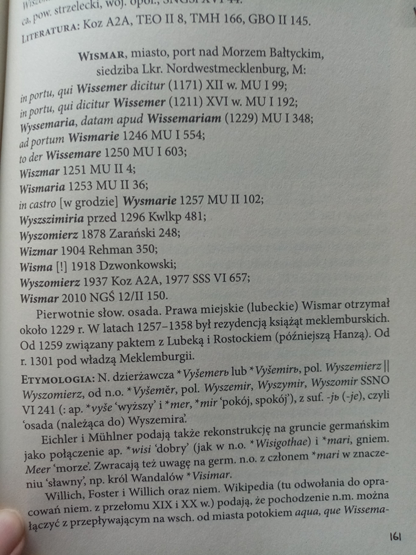
Wismar – Wyszemer (1229 Wyssemaria, 1230 Wissemaria, 1237, 1246 Wismaria, 1250 Wissemare)
Doberan – Dobran (1192 and 1197 Doberan, 1209 Doberan, 1216 Dobran)
Schwerin – Zwerin (1018 Zuarina, 1160 Zuerin)
Grabow - Grabowo (1186 Grabowe, 1189 Grabow, 1259 Grabow, 1262 Grabowe)
Havelberg - Hobolin (in my opinion it's incorrect reconstruction, but it's been established as a name in Polish historiography)
Rostock – Roztoka (throughout the years Rozstoc, Rostoch, Rotstoc, Rotstoch, Rozstoc, Roztoc, Rozstok and Rostok were used)
Gustrow – Gustrowo (Guztrowe, 1228 Guzstrowe, 1232 Guozstrowe, Gutztrowe)
Parchim – Parchom (1170 Parchim, 1225 Parchem, 1227 Parchem, 1229 Parchim)
Ribnitz – Rybnica (1216 rivus Ribeniz, 1225 Ribeniz, 1223 Rybeniz, 1311 Ribbenitze)
Stralsund - Strialow (1234 Stralowe, 1240 Stralesund, 1248 Stralsunde)
Grimmen – Grim (1267 Grimme, 1279 Grimmen, 1304 Grimme, 1326 Grimmis
Rugen – Rana (1149 Rana, Slavic inhabitants were called Rani)
Greifswald – Gryfia (no Slavic name, a later German settlement)
Wolgast – Woligost (1186 Wolegost, 1197 Wolegast)
Anclem – Tąglim (1243 Tanchlim, 1247 Tanchlym, 1251 and1264 Tanchlim, 1280 and 1283 Tanglim 1272 Tanclam)
Demmin – Dymin (1171 Dimin, 1241 Demyn)
Uckermunde - Wkra (1178 provinica Vcra, 1183 Vkra, 1223 Vkramund, 1242 Vkeremunde)
Malchin – Malochinia (1215 Malekin, 1236 Malchyn, 1247 Malechin)
Waren – Warny (1229 Warne, 1273 Warne)
Neubrandenburg – no Slavic name, could be changed to nearby Stargard (Burg Stargard) (1170 Stargart, 1244 Staregart)
Strelitz – Strelice (Strelitz (1278) and Streltza (1350)
Prenzlau - Premyslaw (1188 Prenczlaw, 1235 Prenzlawe, 1237 Premizlawe, 1261 Primzlawe, 1302 Prentzlow)
Templin – Tęplin (1270 Templyn, 1287 Templin)
Angermunde – no Slavic name, could be changed to nearby Swet (Schwedt) (1265 Scwet,1269 Zuet, 1271 Zweth, 1295 Zswet, 1321 Zweth)
Salzwedel – Liastowo (reconstruction from late Polabian Lostüv)
Osterburg – no Slavic name, Rosowo (Rossow) (a part of city of Osterburg) could be used (1184 Nycholai rossow, 1287 Rossow)
Stendal – no Slavic name, no nearby Slavic place names.
Genthin – no Slavic name, could be changed to nearby Jerichowo (Jerichow) (1183 Iericho, 1224 and 1293 Ierichow, 1225 Iericow). No relation to biblical Jericho! Name comes from Old Slavic word meaning, "riverside settlement of the dominant one".
Brandendurg – Brenna (929 Brennaburg, 948 Brinnaburg, likely originally a German name)
Potsdam – Postąpim (993 Poztumpimi, 1304 Postamp, 1459 Potstamp)
Berlin – Berlin (from Old Polabian root berl-, meaning swamp)
Ruppin – Rupin (1237 Olden Rupyn)
Wittstock – Wysoka (948 Wizoka, 1271 Wiztok, 1284 Witzstock, 1441 Witstock)
Herzfelde - couldn't find it.
Freienwalde - no Slavic name, Bralice (Bralitz) (a part of city of Freienwalde) could be used (1337 Bralitz).

1722155888696.png


When it comes to the culture map:
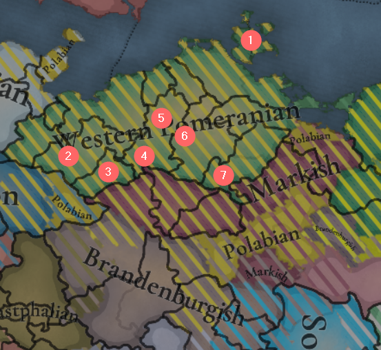
1. Rügen should have a Slavic majority - as I mentioned in an earlier comment in the thread, a few years before the starting date it had a native dynasty, whose members had clearly Slavic names. The names of the nobility from this and later periods are largely Slavic (the Slavic nobility and residents of large centers were the first to undergo voluntary Germanization.
2, 3, 4, 5, 6, 7 - Since these are more remote places, they should either have a Slavic majority or a significant Polabian minority, especially 2 and 3 - according to Samuel Buchholtz's account (Versuch in der Geschichte des Herzogthums Mecklenburg 1753), the Polabian language was preserved in this region (known in German as Jabelheide) even in the 16th century. In the remaining, not numbered on the map locations, there should be fewer Polabians, between 25 and 50 percent in medium-sized centers and between 10 and 25 percent in the largest.

The names of the provinces were inspired by the names of the Slavic tribes living in these areas. A general Slavic tendency, and very strongly present in Western Slavdom, was to create names of lands from the names of tribes, and this is also visible among the Polabians from the 12th-13th centuries (however, these names were replaced by German ones), but they concerned much smaller areas.

Lubeck - Wagria
Gau Polabi - Obodritia
Stralsund - Czrezpenianie
Altmark – Biala Zemia
Zirzipanen - Weleti
Ruppin - Rupin
Uckermark – Wkrianie
Bardengau - Drawanie (Ger. Drawehn)


Finally, the reconstruction of male and female names of medieval Polabians. Some of them were mentioned directly in sources, some were interpreted from the names of settlements. For example reconstruction for city of Wismar in Meklemburg.

1722155530923.png


Vyšemir is personal name (Vyše “higher” + mer/mir “peace”) combined with -jь (possessive suffix), this gives us Vyšemerь, which means “Settlement belonging to Vyšemir”

Male names:
Bialk Barnim Barnuta Bądech Bądimer Bądk Bezmer Bliżegniew Bliżemer Bojan Boleczek Boleslaw Borisz Bornk Buriwoj Buguslaw Chotan Chotebąd Chotemir Czarnota Czarnowąs Dalech Dargobąd Dargoch Dargomysl Dargorad Dargosz Dargoslaw Dargun Darislaw Dobiemer Dobieslaw Dobr Dobriech Dobromer Domastryj Dumamir Grąbesz Gniew Gniewomer Gniewosz Godirad Gorigost Gorislaw Gostiemer Jarogniew Jerk Jeroma Jeromer Jeroslaw Jutrogost Karnasz Kazimer Liub Lubimer Lubola Ludislaw Milogost Mirogniew Mstislaw Myslibor Myslidarg Myslim Naczęmir Nakon Niebur Niemer Niesemer Priedk Preslaw Priezemer Prosimer Pribygniew Pribyslaw Radim Radogniew Radogost Radoliub Radomir Radomysl Radoslaw Radosz Ratibur Ratimer Ratislaw Siemilub Slawotech Sobol Stark Stoislaw Suliąta Swiątobor Swiątopolk Tągomer Techoslaw Teszymer Teszygniew Triebogost Unieslaw Walim Wartislaw Więcegur Witogost Witolub Woligost Wolilub Wyszemer

Female names:
Boguslawa Boleslawa Bożena Barnislawa Brietislawa Dąbrowka Dalimira Dobroniega Dargomira Gostimira Jerka Jermila Jeroslawa Jesza Krieslawa Liuba Ludmila Malomira Miroslawa Mstigniewa Niesemera Pribyslawa Ratibora Radomila Radomira Radoslawa Stibora Slawina Slawomira Smiechna Sobieslawa Stanislawa Swiątoslawa Witoslawa Wyszemera Wera Witoliuba Wojslawa Zdenka Zwinislawa


Sources I used:
  • K. Polański “Gramatyka języka połabskiego” (“Grammar of the Polabian language”) https://sbc.org.pl/Content/18899/gramatyka_jezyka_polabskiego.pdf;
  • K. Polański “Ethymological dictionary of Polabian language” https://starling.rinet.ru/~minlos/Etymological_dictionaries/Polab/;
  • E. Rzetelska-Feleszko “Dawne słowiańskie nazwy miejscowe Pomorza Szczecińskiego” (“Old Slavic toponyms of western Pomerania”);
  • T. Białecki “Słowiańskie nazwy geograficzne w Niemczech, część I” (Slavic toponyms in Germany, part 1a, 1b, 1c”),
  • M. Jeżowa "Dawne słowiańskie dialekty Meklemburgii. Cz. 1. Fonetyka" (Old Slavic dialects of Mecklenburg. Part 1. Phonetics),
  • M. Jeżowa "Dawne słowiańskie dialekty Meklemburgii. Cz. 2. Slowotwórstwo" (Old Slavic dialects of Mecklenburg. Part 2. Word formation),
  • S. Papierkowski "Szczątki języka słowiańskich mieszkańców Starej Marchji i okolic Magdeburga". „Slavia Occidentalis”. IX, s. 73-124, 1930. (Les restes de la langue des Slaves, habitants l'Altmark et les environs de Magdebourg).

There are definitely things I forgot to mention. I'll be happy to answer any questions. In my free time I will try to write a similar post about Lusatia
 
Last edited:
  • 13Like
  • 6
  • 1Love
  • 1
Reactions:
Pomerania feedback

Locations:
View attachment 1168917


Damm:

In 1295 the Duchy of Pomerania was divided by the rivers Peene and Ina between the Duchies of Pomerania-Stettin and Pomerania-Wolgast. The border on the Peene River is good, with Anklam and Demmin on the Stettin side. View attachment 1168918

However, the border on the river Ina is not visible being completely owned by the Naugard location. To show this divide I suggest adding the location of Gollnow or Damm.
Damm (Dam, Damme, Dąbie) got Magdeburg rights in 1260, changed to Lübeck rights in 1293. Gollnow (Goleniów) got Magdeburg rights in 1264 and Lübeck rights in 1314. I chose the former because it is in the center of the province and was the favorite residence of the Stettin Duke Otto I. The border from north and east is the Ina river from west Oder river and Dabie (Damm) Lake and from south the Buchheide (Puszcza Bukowa). Since it was a fishing village, fish should be the trade good there.
View attachment 1168922


Stargard/Saatzig:
The location should be renamed since Stargard was the most important city and trade cnetre in that area. Saatzig was only used as administrative district in german empire.

Treptow/Greifenberg:
Optional rename, both cities in that location were important trade centers.

Kolberg:
Köslin should be divided into Kolberg and Köslin, since they were the 2 most important cities in the bishopric of Cammin. The bishops had their residence in Kolberg and the administration of the diocese was done from Köslin. Kolberg had two salt pans, which were used for mining and later for trade, so the trade good should be salt there. (Jörg Jarnut, Peter Johanek, Die Frühgeschichte der europäischen Stadt im 11. Jahrhundert, Köln-Weimar-Wien 1998, pp.273–305)


The county of Naugard:

View attachment 1168920


Since your inclusion of Regenwalde (Resko) as an independent tag ruled by the von Borcke family, it is hard not to include the "County of Naugard" in the location of Naugard. It was ruled by the Eberstein family from XIII to XVII century. The county is also visible on the Pommern 1377 map higher in this post (Grafschaft Naugard). Gustav Kratz: Die Städte der Provinz Pommern 263-298.


Provinces:
View attachment 1168923
Stettin: added Wolgast, if you wanted to go to the port of Stettin you had to go through these islands. Remove Greifenhagen
Pyritz: Add Greifenhagen, since it is on the western edge of the Pyritz Plain (Równina Pyrzycka). And for balance (6 locations in Stettin, 5 in Pyritz and 7 in Köslin).


Areas:
View attachment 1168924
This region should be split into 3 part:
Mekclenburg
Pomerania (let's use the English name)
Neumark

The borders I drew here are not precise, here are the individual maps of the areas:
Pomerania:

View attachment 1168925

Neumark (with inclusion of Sternberg with the western border on the Oder River):
View attachment 1168926

Mecklenburg:
View attachment 1168928

Thank you very much i wish you a pleasant day.

P.S. I think Markish and Brandeburgian shouldn't be separate, Western Pomeranian should be renamed to Mecklenburgian and Eastern Pomeranian to Pomeranian.
Nice that we all seem to agree on the Markish / Brandeburgish issue, it should all be Markish and that's it. ;)
 
  • 2Like
Reactions: