• We have updated our Community Code of Conduct. Please read through the new rules for the forum that are an integral part of Paradox Interactive’s User Agreement.

Tinto Maps #12 - 26th of July 2024 - Germany

Hello, and welcome to another new Tinto Maps! I’m back to duty, after the review of Italy that we posted last Thursday, and Johan taking care of Scandinavia last Friday. Today we will be taking a look at Germany! This region comprises the modern territories of Czechia, Austria, Switzerland, and Liechtenstein. However, for most of the timeline in Project Caesar, it was better known as the Holy Roman Empire. This organization once was a feudal empire elevated from the Kingdom of the Germans, but by 1337 was mostly disaggregated into a multitude of temporal and ecclesiastical jurisdictions, with only a tenuous feudal relationship with their Emperor.

Let’s start diving deep into this nightmare, then…

Countries:
Countries.png

I’m showing here a bit more of what the region is, so you can have a clear depiction of how it looks compared to the neighboring regions we’ve previously shown (and so that the Reddit guy who is patchworking the world map has an easier day ). What I can say about this when the map speaks for itself… The lands of Germany are highly fractured among different principalities, making for an extremely complex political situation. The Emperor in 1337 was Louis IV von Wittelsbach of Upper Bavaria… Because, yes, Bavaria is also divided. He is married to Margaret of Avesnes, daughter of Count William of Hainaut, Holland, and Zeleand, while his son Louis is the Margrave of Brandenburg. But probably the strongest power of the period is the Kingdom of Bohemia, whose king John also Duke Luxembourg and rules over both lands in a personal union, while also being overlord of the Margraviate of Moravia, ruler by his son Charles, and the Silesian principalities. The third contender probably is the Duchy of Austria, ruled by Albert II von Habsburg. He also rules over some lands in the formed Duchies of Swabia and Carinthia. There are also plenty of medium and small countries all over the region, with very different forms of government, which will probably make this HRE a very replayable experience…

Dynasties:
Dynasties.png

The dynastical map of the HRE gives a nice picture of the situation explained in the previous one. The von Wittelsbach, de Luxembourg (John of Bohemia is considered of French culture, therefore it uses the French toponymic article ‘de’; if he would change to the German culture, then it would be the ‘von Luxembourg’ dynasty), and von Habsburg cover much of the map; you may note that the Wittelsbach rule over five different countries (Upper Bavaria, Lower Bavaria, the Palatinate of the Rhine, and Brandenburg); while the House of Luxembourg also control the Archbishopric of Trier through Balduin, uncle of King John. Other important dynasties, although in a secondary position, are the Welfen, von Mecklenburg, and Gryf, present in multiple countries to the north; the Askanier, who happen to control half of Upper Saxony, while the rest is in the hands of the von Wettin; and the von Görz, who rule over the Duchy of Tirol and the County of Gorizia.

HRE:
HRE.png

We obviously have to repost the HRE IO map again here. The purple stripes mark the imperial territory, while the different types of members use different colors. We currently have these divisions in the IO: the Emperor (1, dark blue), Prince-Electors (4, light blue), Archbishop-Electors (3, medium blue), Free Imperial Cities (23, light green), Imperial Peasant Republics (2, orange), Imperial Prelates (44, white), and Regular Members (280, dark green). So, yeah, that make for a total of 357 countries that are part of the HRE. And before you ask: No, we won’t talk about its mechanics today, that will happen in future Tinto Talks.

Locations:
Locations.png

Locations 2.png

Locations 3.png

Locations 4.png

Locations 5.png
Germany has the highest density of locations in the world, as we wanted to portray the historical fragmentation of the HRE at the most detailed level of any Paradox GSG. There are a couple of things that we are aware of and we want to rework: the location connections (as in some places they are not obvious at all, and we want to make warfare in the HRE not impossible); and the transition between the German locations and those at their east, making it smoother (something that we will be doing in the review of Poland, Hungary and this region [e.g. for Bohemia]). A final comment: if you click on the spoiler button, you may be able to see 4 more detailed maps of the region.

Provinces:
Provinces.png

Map of provinces. As usual, suggestions are welcomed.

Areas:
Areas.png

Areas. We are currently not happy with the area borders (or at least, one of our German content designers isn't, and let me note it while preparing the DD... ;) ), as they reflect more modern areas so we will be looking into an alternative setup for them with your feedback. They also currently use their German names, which will change to English ones to be in line with other areas, as usual.

Terrain:
Climate.png

Topography.png

Vegetation.png

Terrain mapmodes. The region is quite forested, in comparison to other parts of Europe.

Culture:
Cultures.png

Let’s open the Pandora box and take a look at the cultures! The German cultures have come through a couple of reworks, until we’ve found a spot in which we’re kind of happy (or, at least, our German content designers do not complain!). The German cultures are very linguistically related, as we thought that it would be the best starting point for 1337. Please let us know about your thoughts on them.

Religion:
Religion.png

Boring religion map this week, as the region is overwhelmingly Catholic. There are Ashkenazi Jews in a bunch of places (a quick account: they’re present in 204 locations all over Central and Eastern Europe), and you may also see the Waldesians we added in the review of Italy last week.

Raw Materials:
Raw materials.png

Raw materials! Plenty of!

Markets:
Markets.png

The main market centers of the region are Cologne, Lúbeck, and Prague. We have reviewed them a couple of times, and this is the configuration that makes for a good setup historical and gameplay-wise. And you may also see Bruges, which has been reinstated as the main market of the Low Countries, after some tweaks.

Country and Location Population:
Population.png

Population 2.png

Population 3.png

Populations 4.png
The population of the HRE is… Fragmented. In that regard, Bohemia starts in a very strong position, with a strong competitor to its south (Austria) and north (Brandenburg).

And that’s it for today! I hope that we didn’t drive you into madness with this map… Next week we will take to a very different region, the Maghreb! See you then!
 
  • 175Love
  • 121Like
  • 4Haha
  • 4
  • 3
  • 2
Reactions:
Hello I kind of have a problem with the depictions of Lower Saxony and Saxony. I think at least at the start of the game Lower Saxon should still be called Saxon, as the title of Duchy of Saxony wasn't done moving around until 1422.
Also the Culture of Saxon would need to be called something else since Saxon would still be the name of the Lower Saxons. Maybe call the current Saxons Meissner or something.
I don't think the Saxons should be called Saxons yet as the Duchy of Saxony (the old one with the Modern Day Low Saxons) was only Divided by Emperor Barbarossa in 1180 because Henry the Lion (Duke of Saxony) didn't join Barbarossa in some War in Lombardy. And as mentioned the title of Duchy of Saxony was still Moving until 1422.
And on your Map you can still see Meißen, so Saxony isn't fully established.

The term Low Saxon hasn't even been established at the start of the game to differentiate between High and Low Saxons.
So I think the Low Saxons should be called Saxons and it would be incredibly fun to have some kind of Mission to be able to reclaim the title of the Duchy of Saxony as a Low Saxon / Westphalian / Eastphalian / Angrian nation and prevent the High Saxons from being known as Saxons later on.
Maybe there could be a renaming of the cultures once Meißen turns into Saxony with (Low) Saxon then being known as Lower Saxon and (High Saxon) Meissner being then known as Saxons. And if you reclaim the title of Duchy of Saxony you could avoid the renaming of the cultures.

So basically I want to be able to undo the wrong done by Emperor Barbarossa and have Low Saxons continuing to be known as Saxon.

Also as an Eastphalian I want to thank you for representing my Regional culture and Dialect that still is hanging on at the edge of existence. And it's also cool that the Low Saxon / Low German Regions of the Netherlands are Westphalian, so the renaming of Lower Saxon to Saxon would contribute to that beautiful historical accuracy.

[Edit1] Some more Info from the Web Page of the State of Lower Saxony: The Term Lower Saxony was used first in 1354 and was used officially for the first time by 1512
 
Last edited:
  • 2
  • 1Like
  • 1
  • 1
Reactions:
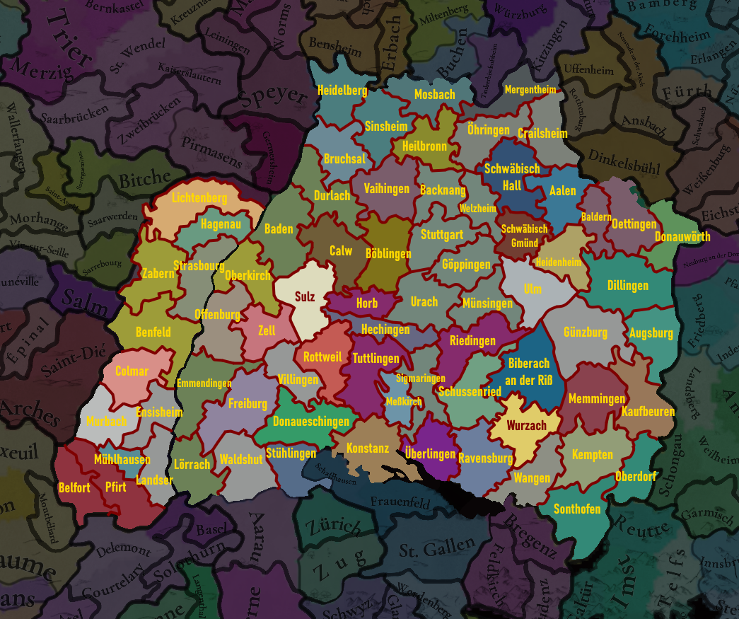
My suggestions / thoughts on Swabia:

Suggestions - Swabia.png


Alsace:
Upper and Lower Alsace are swapped around; Upper Alsace in the south.
- Lichtenberg was an immediate lordship, not a territory of the Bishopric of Strasbourg. German Wikipedia has enough information to implement it:
https://de.wikipedia.org/wiki/Herrschaft_Lichtenberg
https://de.wikipedia.org/wiki/Stammliste_des_elsässischen_Adelsgeschlechts_Lichtenberg
After the family died out with no male heirs in 1471, it's heiresses saw half go to Hanau-Babenhausen and the other half to Zweibrücken-Bitsch (which in turn passed to Hanau-Lichtenberg in 1570).
- Strasbourg was a free imperial city, and did not belong to the bishopric.
- Hagenau, Colmar and Mühlhausen were free imperial cities, not Austrian territories. Austria wasn't the emperor in 1337 so even if you didn't want to create these as free cities at game start, it would still be incorrect to give them to Austria. I've shown all three as free cities above.
- I think the existing Mühlhausen location as it was is problematic because this city was a Swiss ally in 1515, became an independent state in 1648, and was only annexed to France during the revolution. The city also had quite the divergent 'foreign' policy to the rest of the Alsatian Decapolis, and was a Calvinist republic for much of the time frame. None of the territory of this location belonged to the county of Pfirt (Ferette). I see two ways to go here: one rename this location to 'Landser' at give it to Austria at start to retain what I think you're going for with Austrian domination of Alsace, or split the location into Mühlhausen and Landser so that both work.
- Lastly, Murbach was an Imperial abbey, not an Austrian territory. It was heavily in debt so I guess it starting as Austrian isn't too wrong.

Breisgau:
I have some potentially controversial ideas for this region.
- Rename Müllheim to Lörrach, and give to Baden to represent the Baden-Hachberg-Sausenberg rule. This corner of Breisgau was for the entire period Badish, so I don't believe it should be given to Strasbourg.
- I split Stühlingen off from Waldshut to represent the eponymous landgraviate. This was a possession of the counts of Lupfen, who were Austrian allies. The Peasants' War started here in 1524 before spreading across Germany. The counts of Lupfen died out in 1582 and Stühlingen as seized by the house of Pappenheim (though only enfoeffed in 1602), then in 1631 passed to the House of Fürstenberg. Trade good would be wheat, wool or livestock as this was always agricultural.
https://adw-goe.de/digitale-bibliothek/hoefe-und-residenzen-im-spaetmittelalterlichen-reich/id/rf15_IV-2768/
https://www.geni.com/people/Konrad-I-Graf-von-Lupfen/343787217910001836
- The controversial suggestion I have is to not include Triberg, which markes space of other locations instead:
- Without Triberg, Freiburg becomes the northern half of Austria's Breisgau possessions, making the borders recognisable.
- There's now space to add Emmendingen in the west of was formerly Freiburg. Emmendingen was the centre of the house of Baden-Hachberg, a separate line of the Zähringer that sold itself off to the main Baden branch in 1415. The early economy here was built on Lumber.
- With Villingen expanded northwards to take the Austrian lands formerly Triberg, there's now room for Donaueschingen too. This was the centre of the counts of Fürstenberg, who ruled the area until mediatised to Baden in 1806. Trade good would be wool, and Donaueschingen has had a long-running brewery. German Wikipedia comes in clutch with the details of the family:
https://de.wikipedia.org/wiki/Fürst...afen_und_Fürsten_von_Fürstenberg-Heiligenberg

Ortenau:
- I feel like Oberkirch is misplaced. The territories of the Bishopric of Strasbourg were more to the north - I've got it taking land from Offenburg it to border the Rhine.
- The space left over from moving Oberkirch and removing Triberg leaves room in the southwest of the Ortenau for a new location. I went with the Imperial City of Zell (am Harmersbach). Zell starts as a Badish territory, but by the end of the 14th Century was a free city, remaining so until 1803. It was an ally of Offenburg.

Ufgau:
- Durlach was misshapen. It should have that bit that dangles over Calw. To compensate, I extended Bruchsal slightly into the Palatinate.

Hegau:
- I think that the Imperial City of Rottweil is more important that Oberndorf, so I moved Tuttlingen out of the way and removed Oberndorf to make space for it. It was the site of one of the most important courts during early game period, and is also what the rottweiler dog breed is named after. Rottweil allied the Swiss in 1463, and kept the alliance until it was annexed by Württemberg in 1802. Rottweil was a centre of cattle trading, so trade good should be livestock.
- Ballingen found itself with Tuttlingen when I added Rottweil, so in place of it I've added Sigmaringen and Meßkirch. Sigmaringen belonged to Württemberg at game start before passing to Hohenzollern in 1535. It remained part of Hohenzollern until its abolition in 1946. Sigmaringen's trade good would be Livestock. Meßkirch starts in 1337 as a marital union of Zimmern and Rohrdorf, so it'd be fine to start with Werner von Zimmern as baron. Meßkirch was a cultural and intellectual centre in the region during the renaissance. The Zimmerns were succeeded by the Helfensteins in 1594, and they in turn by the Fürstenbergs in 1627 who would rule it until mediatisation to Baden in 1806. Was also an agricultural area so trade good livestock. If you feel that the two locations are too much, I would still recommend either of them over Ballingen.
https://de.wikipedia.org/wiki/Zimmern_(Adelsgeschlecht) (usable coat of arms: https://de.wikipedia.org/wiki/Meßkirch#/media/Datei:DEU_Meßkirch_COA.svg)

Linzgau:
- I replaced Waldsee with Wurzach, simply because Wurzach was directly ruled by the Waldburgs, and you've added Riedlingen, a city they would in time come to rule.
- I shifted Riedlingen north of the Danube to occupy the lands of all the lordships and abbeys between Württemberg and the Danube. In the remaining space the most significant location would probably Schussenried abbey, though I sense that you guys aren't too keen on adding any abbey if you can avoid it. Schussenried produced a lot of peat. This is here as a suggestion on the off-chance you do want one of the many, many prince abbeys in this corner of the Empire.

Albuch:
- Heidenheim was ruled by the counts of Helfenstein until passing to Württemberg in 1448.

Oberschwaben:
- I think this name should be changed. Upper Swabia refers to a much larger area than just this region, so maybe Burgau would be better?
- Oettingen is placed almost fully in the wrong location (currently Aalen). I think there is room within Donauwörth if borders are adjusted to place Oettingen as its own location where it should be.
Hohenloher Ebene:
- As mentioned just above, you've placed Oettingen in Aalen instead of where it should be. Aalen was a free city. Alternatively this location is almost entirely comprised of the Provostry of Elwangen.
- Baldern is a possible addition, split of from both Aalen and Heidenheim to contain the western sliver of Oettingen that was mediatised to Württemberg in 1810. It might be better to not include it separately at all.
- Schwäbisch Gmünd was an important free city during this period which you might also consider adding. It became a major producer of gold and silver crafts in the 17th Century.

Areas:
I think the division into eastern and western Swabia is a bit of kludge. My suggestion: Upper Swabia (Linzgau, Allgäu and Oberschwaben), Lower Swabia (Albuch, Strohgäu, and Hohenloher Edene), and the Black Forest (Hegau, Breisgau, Ortenau and Ufgau).
 
  • 11Like
  • 3
  • 1
Reactions:
Oh, yes, Switzerland. We're considering making the Swiss Confederation an IO, at least in its initial stage of formation, yes!
Is there scope to make it so that a player part of an IO and not necessarily its most powerful member or leader can choose to play as a nation formed by the IO(swiss confederacy, Scotland technically getting a 'PU' on england historically, native federations if there are similar mechanics to eu4?)

Something like choosing to play New Providence/Zulu in eu4 but instead it's more of a 'promotion'
 
1722080470477.png


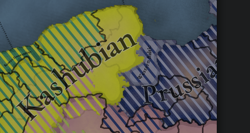
Excuse me why da hell is Gdańsk/Danzig and other locations on the left side of Vistula WESTERN BALTIC???? Baltic settlements never corssed Vistula and that river was for ages border between Kashubians (Pomeranians) and Baltic Prussians. Also Gdańsk is historical capital of Kashubia it makes no sense for Western Baltic in those areas @Pavía pls fix that
 
  • 4Like
  • 4
  • 1
Reactions:
1722081253320.png

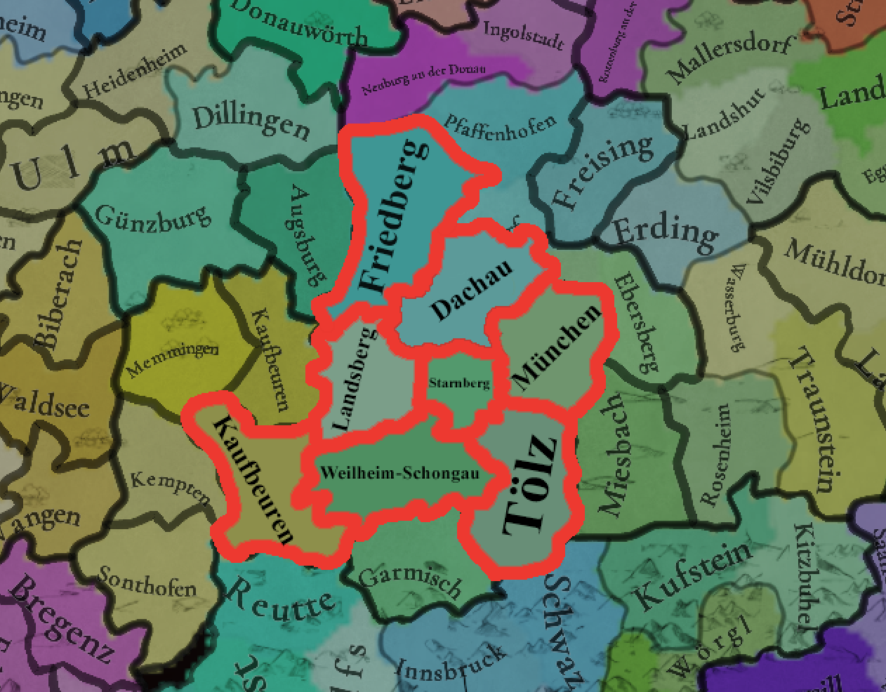
Suggestions for changes in and around Munich
 
  • 1
Reactions:
View attachment 1168598

Excuse me why da hell is Gdańsk/Danzig and other locations on the left side of Vistula WESTERN BALTIC???? Baltic settlements never corssed Vistula and that river was for ages border between Kashubians (Pomeranians) and Baltic Prussians. Also Gdańsk is historical capital of Kashubia it makes no sense for Western Baltic in those areas @Pavía pls fix that
You should write this feedback into Poland Tinto Maps
 
  • 1Haha
Reactions:
I think someone said it in the Italy feedback post but Triest should be majority Friulian(or maybe Venetian/Dalmatian) in 1337, even if you take in consideration cities like Monfalcone or towns in the countryside the majority of population spoke a Romance based language and definilty not Slovenian due to its commercial ties with Venice
 
  • 1Like
Reactions:
My suggestions / thoughts on Swabia:

View attachment 1168513

Alsace:
Upper and Lower Alsace are swapped around; Upper Alsace in the south.
- Lichtenberg was an immediate lordship, not a territory of the Bishopric of Strasbourg. German Wikipedia has enough information to implement it:
https://de.wikipedia.org/wiki/Herrschaft_Lichtenberg
https://de.wikipedia.org/wiki/Stammliste_des_elsässischen_Adelsgeschlechts_Lichtenberg
After the family died out with no male heirs in 1471, it's heiresses saw half go to Hanau-Babenhausen and the other half to Zweibrücken-Bitsch (which in turn passed to Hanau-Lichtenberg in 1570).
- Strasbourg was a free imperial city, and did not belong to the bishopric.
- Hagenau, Colmar and Mühlhausen were free imperial cities, not Austrian territories. Austria wasn't the emperor in 1337 so even if you didn't want to create these as free cities at game start, it would still be incorrect to give them to Austria. I've shown all three as free cities above.
- I think the existing Mühlhausen location as it was is problematic because this city was a Swiss ally in 1515, became an independent state in 1648, and was only annexed to France during the revolution. The city also had quite the divergent 'foreign' policy to the rest of the Alsatian Decapolis, and was a Calvinist republic for much of the time frame. None of the territory of this location belonged to the county of Pfirt (Ferette). I see two ways to go here: one rename this location to 'Landser' at give it to Austria at start to retain what I think you're going for with Austrian domination of Alsace, or split the location into Mühlhausen and Landser so that both work.
- Lastly, Murbach was an Imperial abbey, not an Austrian territory. It was heavily in debt so I guess it starting as Austrian isn't too wrong.

Breisgau:
I have some potentially controversial ideas for this region.
- Rename Müllheim to Lörrach, and give to Baden to represent the Baden-Hachberg-Sausenberg rule. This corner of Breisgau was for the entire period Badish, so I don't believe it should be given to Strasbourg.
- I split Stühlingen off from Waldshut to represent the eponymous landgraviate. This was a possession of the counts of Lupfen, who were Austrian allies. The Peasants' War started here in 1524 before spreading across Germany. The counts of Lupfen died out in 1582 and Stühlingen as seized by the house of Pappenheim (though only enfoeffed in 1602), then in 1631 passed to the House of Fürstenberg. Trade good would be wheat, wool or livestock as this was always agricultural.
https://adw-goe.de/digitale-bibliothek/hoefe-und-residenzen-im-spaetmittelalterlichen-reich/id/rf15_IV-2768/
https://www.geni.com/people/Konrad-I-Graf-von-Lupfen/343787217910001836
- The controversial suggestion I have is to not include Triberg, which markes space of other locations instead:
- Without Triberg, Freiburg becomes the northern half of Austria's Breisgau possessions, making the borders recognisable.
- There's now space to add Emmendingen in the west of was formerly Freiburg. Emmendingen was the centre of the house of Baden-Hachberg, a separate line of the Zähringer that sold itself off to the main Baden branch in 1415. The early economy here was built on Lumber.
- With Villingen expanded northwards to take the Austrian lands formerly Triberg, there's now room for Donaueschingen too. This was the centre of the counts of Fürstenberg, who ruled the area until mediatised to Baden in 1806. Trade good would be wool, and Donaueschingen has had a long-running brewery. German Wikipedia comes in clutch with the details of the family:
https://de.wikipedia.org/wiki/Fürstenberg_(schwäbisches_Adelsgeschlecht)#Grafen_und_Fürsten_von_Fürstenberg-Heiligenberg

Ortenau:
- I feel like Oberkirch is misplaced. The territories of the Bishopric of Strasbourg were more to the north - I've got it taking land from Offenburg it to border the Rhine.
- The space left over from moving Oberkirch and removing Triberg leaves room in the southwest of the Ortenau for a new location. I went with the Imperial City of Zell (am Harmersbach). Zell starts as a Badish territory, but by the end of the 14th Century was a free city, remaining so until 1803. It was an ally of Offenburg.

Ufgau:
- Durlach was misshapen. It should have that bit that dangles over Calw. To compensate, I extended Bruchsal slightly into the Palatinate.

Hegau:
- I think that the Imperial City of Rottweil is more important that Oberndorf, so I moved Tuttlingen out of the way and removed Oberndorf to make space for it. It was the site of one of the most important courts during early game period, and is also what the rottweiler dog breed is named after. Rottweil allied the Swiss in 1463, and kept the alliance until it was annexed by Württemberg in 1802. Rottweil was a centre of cattle trading, so trade good should be livestock.
- Ballingen found itself with Tuttlingen when I added Rottweil, so in place of it I've added Sigmaringen and Meßkirch. Sigmaringen belonged to Württemberg at game start before passing to Hohenzollern in 1535. It remained part of Hohenzollern until its abolition in 1946. Sigmaringen's trade good would be Livestock. Meßkirch starts in 1337 as a marital union of Zimmern and Rohrdorf, so it'd be fine to start with Werner von Zimmern as baron. Meßkirch was a cultural and intellectual centre in the region during the renaissance. The Zimmerns were succeeded by the Helfensteins in 1594, and they in turn by the Fürstenbergs in 1627 who would rule it until mediatisation to Baden in 1806. Was also an agricultural area so trade good livestock. If you feel that the two locations are too much, I would still recommend either of them over Ballingen.
https://de.wikipedia.org/wiki/Zimmern_(Adelsgeschlecht) (usable coat of arms: https://de.wikipedia.org/wiki/Meßkirch#/media/Datei:DEU_Meßkirch_COA.svg)

Linzgau:
- I replaced Waldsee with Wurzach, simply because Wurzach was directly ruled by the Waldburgs, and you've added Riedlingen, a city they would in time come to rule.
- I shifted Riedlingen north of the Danube to occupy the lands of all the lordships and abbeys between Württemberg and the Danube. In the remaining space the most significant location would probably Schussenried abbey, though I sense that you guys aren't too keen on adding any abbey if you can avoid it. Schussenried produced a lot of peat. This is here as a suggestion on the off-chance you do want one of the many, many prince abbeys in this corner of the Empire.

Albuch:
- Heidenheim was ruled by the counts of Helfenstein until passing to Württemberg in 1448.

Oberschwaben:
- I think this name should be changed. Upper Swabia refers to a much larger area than just this region, so maybe Burgau would be better?
- Oettingen is placed almost fully in the wrong location (currently Aalen). I think there is room within Donauwörth if borders are adjusted to place Oettingen as its own location where it should be.
Hohenloher Ebene:
- As mentioned just above, you've placed Oettingen in Aalen instead of where it should be. Aalen was a free city. Alternatively this location is almost entirely comprised of the Provostry of Elwangen.
- Baldern is a possible addition, split of from both Aalen and Heidenheim to contain the western sliver of Oettingen that was mediatised to Württemberg in 1810. It might be better to not include it separately at all.
- Schwäbisch Gmünd was an important free city during this period which you might also consider adding. It became a major producer of gold and silver crafts in the 17th Century.

Areas:
I think the division into eastern and western Swabia is a bit of kludge. My suggestion: Upper Swabia (Linzgau, Allgäu and Oberschwaben), Lower Swabia (Albuch, Strohgäu, and Hohenloher Edene), and the Black Forest (Hegau, Breisgau, Ortenau and Ufgau).
While I disagree with some of your choices, you're a much better artist than I am and I commend you for this great work. Rather than Baldern did you think about adding Nördlingen? Also nothing north of Schwäbisch Hall should be in Swabia.
 
  • 1
Reactions:
I think someone said it in the Italy feedback post but Triest should be majority Friulian(or maybe Venetian/Dalmatian) in 1337, even if you take in consideration cities like Monfalcone or towns in the countryside the majority of population spoke a Romance based language and definilty not Slovenian due to its commercial ties with Venice
Only the town, the countryside was entirely Slovenian. At that time, the town had approximately 5,000 inhabitants.
 
  • 3Like
Reactions:
It's a map of nightmare.
 
maybe I'm gonna get criticized about this by half of the german speaking world... but what the f*uck is that Danube Bavarian/Southern Bavarian division?!?
To be clear I'm not saying that linguistically or culturally they have no differences or that they should be the same, but why not just divide those 2 vertically between with Bavarian(Bavaria proper, Tyrol and maybe Saltzburg) and Austrian(Austria proper, Styria and maybe Saltzburg)?
Culturally speaking they are very similar to this day just like they were in 1337(I assume that's the reason you divided it like that) but dividing it in this way makes more sense from a gameplay perspective so to not incentivize Austria to expand into Bavaria and instead consolidate the eastern lands(especially if Styria ends up being a separate tag) like they did historically and it also looks waaaay better visually to have Austria being Austrian instead of Danube Bavarian.
 
  • 2
  • 1Like
  • 1
Reactions: