• We have updated our Community Code of Conduct. Please read through the new rules for the forum that are an integral part of Paradox Interactive’s User Agreement.

Tinto Maps #15 - 23rd of August 2024 - Horn of Africa

Hello, and welcome one more week to Tinto Maps! After a short break, we’re back to the duty of sharing more maps! Today the region we will look at is the Horn of Africa! So let’s take a look at it, without further ado:

Countries:
Countries.PNG

Here we have the countries around Nubia, Ethiopia, and Somalia. The first ones are organized around the ancient kingdoms of Makuria and Alodia, which control the Upper Nile region. In the second area, the Empire of Ethiopia stands as the main power, with some smaller countries around it. Finally, the two Islamic sultanates of Ifat and Ajuraan stand as the main powers in the Horn and Somalia. Finally, around the African Great Lakes, there is a country that can be considered a ‘settled’ one, Kitara.

Dynasties:
Dynasties.PNG

The dynasties of the Horn. There are some historical ones, while others are randomly generated. The most famous one is probably the Ethiopian House of Solomon, from where all their Negus come. The Walshma ruler over both Ifat and Ajuraan and we have some others, such as the Medri of Medri Bahri, the Umar of Mogadishu, the Banu Kanz of Makuria, or the Baranzi of Kitara.

Societies of Pops:
Pop-Based.PNG

A new map has popped up! Here you can see the countries that we consider as ‘Societies of Pops’, as they were presented in the last Tinto Talks. We have the famous Oromo people in the lands between Ethiopia, Ifat and Ajuraan; the Kunama, Gumuz, and Berta in the lands between Ethiopia; and Alodia, and the Zaghwa to the north of Wadai; there are a few more to the west, but I’ll share that picture in the Western Africa thread, as it’s more appropriate there. There are more Stateless Societies of this kind that we would like to add in the future, if it is possible due to our schedule.

Locations:
Locations.PNG

Locations 2.png

Locations 3.png

Locations 4.png

Locations 5.png
Locations! You might notice that the density is quite unequal. Unfortunately, the archaeological findings for the period are scarce, specially out of the most known areas and a lack of urbanization in most of the territory has made the finding of proper non-anachronistic settlements quite a challenge. Keep this in mind when making suggestions. ;) It has been that dramatic in some areas that we had to use names of tribes and rivers, a bit contradicting our own rules, but the areas had to be represented as they were active parts in the development of the region.
One thing: a big chunk of the Arabian peninsula can be seen in today’s Tinto Maps; but, please, reserve the feedback for its future DD, when we’ll show all of the peninsula. Apart from that, you can see more detailed maps if you click on the spoiler button, as usual.


Provinces:
Provinces.png


Areas:
Areas.png


Terrain:
Climate.png

Vegetation.png

Topography.png

The terrain types of the region are quite interesting and diverse. It is marked by the Rift Valley, which creates different biomes, such as the Ethiopian Highlands and Plateau, or the African Great Lakes. That also marks a divide between Arid, Tropical, and Oceanic climates. The vegetation of the region also ranges from desertic and sparse, to jungle forests. And one more note: you may also note that 'Marshes' have been renamed into 'Wetlands', as we could put some work into that suggestion the last week.

Natural Harbors:
Natural Harbors.png


Cultures:
Cultures.png

Another interesting map this week… You might notice that the lands of Ethiopia have a very mixed cultural situation. While more to the west and south, we are representing ‘tribal lands’ in a more homogeneous way, with kind of fixed boundaries to represent the different groupings. This doesn’t mean that there wouldn’t be a mixing of cultures, but this was one of the first areas to receive a minority's review and the scope was limited mostly to Ethiopia.

Religion:
Religion.png

Another interesting map! Miaphysite and Sunni are the more widespread religions in the region (while not all areas have their mixed populations, such as Nubia as you might notice, they eventually will as we cover more of the map in our sprints). Animism is completely placeholder, as usual, and you might see some pockets here and there (If you have specific suggestions, please do them). You may also notice a purple minority inside Ethiopia… That is representing the Beta Israel Judaism in the provinces of Semien, of course!

Raw Materials:
Raw Materials.png

The raw materials of this week! A big chunk of the region has livestock as its main raw material, while also having some agricultural goods as Wheat or Sturdy Grains here and there. The most unique good in the region is Coffee, which is cultivated in the Ethiopian highlands. And there are also some precious resources spread here and there, such as Gold, Ivory, Gems, and Incense.

Markets:
Markets.png

The main market centers of the region are Axum and Mogadishu, with ‘Adan/Aden being the main one controlling the access to the Red Sea. There are some weird calculations ongoing on the Somalian inner lands, that are already reported, and we’ll take a look at why is that happening.

Population:
Population.png

Population 2.png

Population 3.png

Population 4.png

Population 5.png
The population of the region! There are approximately 12.3M people in the Eastern African subcontinent; although take into account that it also comprises the regions of the Southern Great Lakes and the Swahili Coast, which we haven’t shown today, so we probably have to discount around 4M people from it (Swahili Coast accounts for 1.7M, and the Great Lakes for 4M, although that region is divided between today’s and next week’s Tinto Maps), for a total of around 8M.

That’s all for today! Speaking of next week’s Tinto Maps, it will be meaty, as it will cover Central, Eastern, and Southern Africa! See you!
 
  • 126Like
  • 39Love
  • 5
  • 4
  • 1
Reactions:
Proposal to add a new province Arba'īn
Both Laqya and Shebb are described as villages
gj.png

It is difficult to say whether these oases were even inhabited by people in 1337. So adding them is not necessary.
Map on page 244

4.png

trades.png

trs.png

trade.png

Zrzut ekranu 2025-01-11 195700.png

Arba'īn Province
- Selima
sal.png
- Laqiya/Laqia
laq.png
- Bir Shab/Shebb
bir Sha.png
- Al'Atun/Atrun
 
Last edited:
  • 2Like
Reactions:
Not-EUV starts over 100 years before EUV, at a time when much of what is now northern Sudan was dominated by the Nubian kingdom of Makuria. Makuria's roots go back to the so-called post-Meroitic period, the turbulent era after the collapse of the kingdom of Kush in the 4th century. Makuria's capital Dongola (Nubian: Tungul) was founded in around 500. Soon after it converted to Christianity. In the 7th century it beat back the Arab invasion, with both sides declaring a sort of truce, the baqt, at the price of an annual tribute of 400 slaves. Both Muslim Egypt and Makuria remained at peace throughout the centuries, interrupted by occasional raids and counter raids. Trade was blossoming, especially during the Fatimid period (969-1171). In 1272 and 1276 respectively king David of Makuria challenged the recently established Mamluk Sultanate, raiding Aidhab and Aswan. The Mamluks responded by invading Makuria and capturing him and much of his family and turning Makuria into a vassal state. For the next decades Makuria was ruled by puppet kings, often challenged by pretenders. Most of these individuals were direct relatives of David, his nephews. In medieval Nubia it were the sons of the king's sister who became the next king, elected by an elite class Arabic sources called "princes".

Dotawo.png

Anonymous Makurian king protected by saints, late 13th-mid 14th century

Things took a turn in the early 14th century: in 1316 the Mamluks installed a Muslim prince, Abdallah Barshanbu, on the Makurian throne. He was a nephew of David who had converted to Islam while in Cairo. He was highly unpopular among the population, perhaps because he tried to introduce sharia laws like the jizya headtax for non-Muslims. He was overthrown and killed by another Muslim nephew of David, Abu Abdallah Muhammad, who also happened to be the Emir (Kanz ad-Dawla) of the Banu Kanz who ruled Aswan in Upper Egypt. This individual ruled from 1317 until about 1328. By 1331 he had been ousted and was reduced to being an Emir once again. The new king of Makuria was Siti, a Christian Nubian. We don't know if he was related to David, we only know that his mother was called Asermari. He is attested from documents found in Edfu (upper Egypt) and Qasr Ibrim (Lower Nubia) as well as a graffito from Banganarti (near Dongola) and Jebel Abu Negila (northern Kordofan). We don't know how long he ruled and sources for the period between 1334 (the last dated document of Siti) and 1365 (the fall of Dongola) are very sparse. It seems reasonable, however, to suppose that Siti still ruled in 1337, when not-EUV begins. Historically, Makuria continued to function until a civil war in 1365, when the king fled Dongola. Afterwards Makuria was restricted to Lower Nubia, with the fate of its southern provinces remaining largely unknown. Makuria continued to exist until around the late 15th century, with its last known king being Joel (ca. 1460). Islam finally superseded Christianity in Nubia from the 16th century, with the arrival of the Ottomans in the north and the Funj in the south.

Siti.png

Document from Qasr Ibrim issued under king Siti, 1334

The provinces

The main purpose of this post is to suggest new, more historically accurate location names and borders. As a reminder, these are the current locations:

Maku.png


This is my suggestion:

Makuria EUV.png


As you can see the size of most locations has been drastically reduced, as I am aiming for a more realistic approach reflecting that Makuria was, just like Egypt, a kingdom centered around the River Nile. The number of locations has been reduced from 14 to 10. I tried to consider the location's relevance both in the medieval (until ca. 1500) and the post-medieval (ca. 1500-1821) period. I will explain every location from north to south.

1) Talmis
This location represents the Dar al-Kunuz. Historically, the Banu Kanz were ousted from Aswan in 1410/1 and settled in this region. The local Nubians converted to Islam and assumed their name, becoming the Kunuz. It extends from Philae to Korosko. Historically, the small strip between Wadi es-Sebua and Korosko was inhabited by another tribe, the Aleiqat, but due to its small size I decided to just include it in this location. Historically, this part of Nubia appears to have been rather underdeveloped: William Adams has only identified two late medieval churches here. In the post-Medieval period, when Lower Nubia was ruled by the Ottomans, there doesn't seem to have been a major urban center in this region. The capital I chose is Talmis. It was probably mentioned by Ibn Shadad ("Darm.s") when the Mamluks invaded Makuria in 1276 and was also one of the few locations where a (crude) church was errected in our period. It had assumed its modern name Kalabsha when Evliya Celebi visited Nubia in 1672.

2) Phrim
Phrim is the Nubian spelling of Qasr Ibrim (alternatively also Silimi). This location is famous for its castle and because it was the residence of the Eparch of Nobadia, who governed Lower Nubia on behalf of the Makurian king. It became a major fortress under the Ottomans, who even named the sanjak ("province") after it, although the civil administration was at nearby Dirr. Its northern border is at Korosko, historically the border between the speakers of Nobiin (a Nubian language) and the Arabic-speaking Aleiqat. After the fall of Dongola in 1365 and the migration of the Banu Kanz five decades later this became Makuria's northernmost province. It southern border is somewhat arbitrary, but is near Adda.

3) Adda
The Arab sources called this castle Daw, the medieval Nubians Addo or Atwa and the modern Nubians called it Adda. Adda/Atwa/Addo became the capital after the civil war of 1365 and remained a majort stronghold under the Ottomans until it was abandoned in the late 18th century. It extends as far south as the 2nd cataract, which al-Maqrizi described as Makuria's southern border after 1365/6.

4) Kulb
Kulb represents the Batn al-Hajar or Kidin Tuu, the extremely inhospitable stretch of the Nile between the 2nd cataract and the Dal cataract. It was always sparsely inhabited, with the population reaching its peak in the late medieval period. In the medieval period the most prominent location was Meinarti, an island just south of the 2nd cataract. It was, however, abandoned in the 15th century. Therefore I chose Kulb (a modern name). A large settlement existed here as early as the 9th century before the population shifted to a seasonal island known as Kulubnarti in around the 11th century. The settlement on Kulubnarti was one of the largest in the Batn al-Hajar throughout most of our time period.

5) Sai
Sai was a prominent island settlement and even functioned as a bishopric. It appears that the settlement was already in decline by 1337, although the Ottomans restored its fortress and turned Sai into the capital of the Sanjak of Sai. Its borders range from the Batn al-Hajar in the north to the 3rd cataract, the southern border of the Makurian Nobatia province and the Sanjak of Sai.

6) Argo / Mushu
My first choice is Argo, an island settlement that is admittedly not attested until 1672. In the Islamic period Argo was the seat of a small "kingdom" loyal to the Funj. There is only vague evidence for a medieval settlement on the island. More evidence comes from opposite the island, with reports of several ruined medieval settlements identified by Derek Welsby. Alternatively to Argo one might consider nearby Mushu, on the western bank of the Nile. Like Argo it is attested only from 1672. While not as relevant as Argo, we have evidence that Mushu might have already existed in the medieval period (though not necessarily under the same name), namely several funerary inscriptions, a ruined church and reports of settlement ruins. The borders are inspired by the Jawabra tribe (a branch of the Danagla) of the Islamic period, who settle from the 3rd cataract as far south as Teiti.

7) Dongola
Dongola, the capital of Makuria and later the capital of the Dongola province of the Funj period. It extends as far upstream as Korti, which in the Funj period was the border between the Danagla and the Shaiqiya.

8) Nuri
This location represents the Shaiqiya, an unruly tribe who terrorized much of the Sudanese Nile Valley in the 18th and early 19th centuries after emerging around 1700 (with a possible mention as early as 1529). They were divided into four chiefdoms, with their respective seats being Hannek, Kajiba, Merowe and Amri. The problem is that there is little evidence that these places already existed in the medieval period. Therefore I went with Nuri, which featured a church of modest size and is mentioned in a graffito from Banganarti (late 13th to mid-14th century). Nuri was apparently also of some relevance in the late 16th century, as it was mentioned by the Tabaqat wad-Dayfallah (early 19th century) as a place controlled by Ajib before he rebelled against the Funj. The eastern border is the 4th cataract region, where the Shaiqiya bordered the small Manasir tribe.

9) Shankir
Shankir was the name of a gold-producing province and bishopric. The name seemingly lived on in the Islamic period, now known as Shemkhiyya, which was also the name of a castle. We are very ignorant about the settlement history of this region, which is why I simply equated Shemkhiyya castle with Shankir, assuming that Shankir was also the name of a town. This location represents Makuria's easternmost province, bordering the obscure kingdom of "the gates" (al-Abwab) that is mentioned by Muslim sources between 1276 and 1317. According to Ibn al-Furat, who described events in 1276, al-Abwab began three days journey south of a large island of three days journey in width, which must be a reference to Mograt island. Therefore the border between Makuria and al-Abwab was somewhere about Artul island.

10) Haraza
Even more obscure than Shankir. It is named after Jebel Haraza, the largest and most famous mountain of northern Kordofan. Northern Kordofan had been under Makurian influence at least since the 10th century, with its inhabitants usually being referred to by Muslim sources as jabaliyyun, "hillmen". These "hillmen" spoke so-called "Hill-Nubian" languages that are quite distinct from the Nubian languages spoken along the Nile, would have been nominal Christians at best and practiced a semi-sedentary lifestyle. The borders are very vague: in the west we have the course of the Wadi Malik as far southwest as Jebel al-Ain, where the remains of a monastery were found. In the south we have Jebel Haraza itself, where a few Christian graves were found. The east is marked by the Wadi Muqaddam, which seperates Kordofan from the Bayuda steppes and is rich in medieval artifacts. The Bayuda is not included because since as of now there is very little evidence that Makuria (or Alodia) exercised any real control there.
 

Attachments

  • Dotawo.png
    Dotawo.png
    855 KB · Views: 0
  • Makuria EUV.png
    Makuria EUV.png
    175,7 KB · Views: 0
Last edited:
  • 7Like
  • 4
  • 1Love
  • 1
  • 1
Reactions:
This is a great suggestion! But could I propose that you try to divide the haraza province into at least another location? Alternatively you could add some wastelands in that area. As it is it looks a tad too big.
 
I hope they fix the aden market overlap soon

Also the axum trade MAP is quite anachronistic

Axum wasn't a coastal city and didn't have any impact on coastal or regional trade that honour mostly fell to the coastal city of zeila as well as other ifat and later adal owned cities that held the bulk of exports and imports going in and out of region during this time
 
  • 1
Reactions:
I think the locations in the Harar Plateau should be much smaller to be the same sizes as Ethiopia's. Some states: Hubat, Gidaya, Fatagar, Fedis, Biqulzar, Kwelgora. Zeila should probably be tiny
 
Last edited:
  • 1Like
Reactions:
I hope they fix the aden market overlap soon

Also the axum trade MAP is quite anachronistic

Axum wasn't a coastal city and didn't have any impact on coastal or regional trade that honour mostly fell to the coastal city of zeila as well as other ifat and later adal owned cities that held the bulk of exports and imports going in and out of region during this time
Zeila would make much more sense as a trade centre than Axum
 
Have you got the provinces of ifat and adal the wrong way round or am I just thick

I agree with you, but it seems pretty nebulous

Adal is described to be based in the Harari highlands, while Ifat was located further west past the left bank of the Awash river. So rather than dividing Ifat and Adal by north and south, it might have been better to split them into east-west?

But today, modern Zeila is in the Awdal region of Somaliland (named for Adal), given the importance of Zeila to Adal historically. So I agree flipping the names to have Adal being labeled as coastal with Ifat as inland would indeed make more sense?

Wow though--kudos to the devs for navigating issues like this over the entire world
 
  • 2
Reactions:
Suakin should be owned by the Mamluks since 1317
In 1316-1317/1319-1320 the Mamluks took away the power of the Artega tribe over the city of Suakin and gave it to the Tribe of Bali/Balaw (Al-Khasa). This tribe previously ruled the city but due to marriage bonds they lost their power to the Artega tribe. The Artega tribe will return to power over the city in the 16th century with the support of the Funj/Senar Sultanate.
This country depends on the Sheriffs of Mecca and the Mamluks.


  • 3
Reactions:
Proposal to add a new province Dar al-Atbara
The name of the province comes from the Atbara River
ggg.png


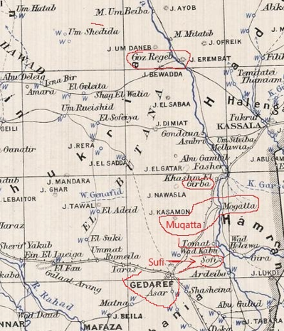
This province includes the city of Gadarif and Mount Teawa located west of the city of Gadarif.
This region is inhabited by two Arab tribes, Shukria and Bawadra. Bawadra As a tribe may have ruled this area in 1337.
According to the Bawadra accounts, Saad is the son of Mak Mahmoud and the grandson of Mak Jasser, who ruled the Butana from Jabal Tawawa, and participated in the Funj alliance that eliminated the Christian state of Alwa.
It was a tribal territory that fell under the influence of the Funj sultans of Sennar in the 16th century . Hasan ibn Hassuna, grandson of a Maghrebi emigrant, established a patriarchal lordship in the Butana region dedicated to cattle breeding and the export of horses to the Sennar and other kingdoms; the lordship maintained a small army and a good number of slaves. Hasan died in 1664/1665 , and the Sega Nissaga continued to the front as vassals of Sennar. At the end of the 18th century with the disintegration of the Funj sultanate, the area passed into the hands of the Shukriyya tribe who became the dominant power in Bhutan.
Quote from the Arabic Facebook page:
Therefore, we find that the Al-Bawadra tribe is one of the ancient Sudanese tribes that is spread in different parts of Sudan, and the largest part of it is concentrated in eastern Sudan, and its history has not been recorded to the extent that allows many to know it comprehensively. It is one of the Arab tribes that inhabit the Butana region and is located north of Gedaref and New Halfa along the Atbara River. And on the Blue Nile in some areas to the east, from eastern Sennar to the outskirts of the capital, in villages distributed and sometimes mixed with other tribes. It is an Adnani tribe of Quraish whose lineage goes back to the Messenger of God, may God bless him and grant him peace, and to the elite of the good people, our master Jaafar bin Abi Talib. It entered Sudan in the fourteenth century AD as part of the Arab migrations at that time.
The tribe's participation in the historic alliance organized by Abdullah Jama'a and Amara Dunqas and led by Sheikh Ajib Al-Manglik, the main ally of the Bawadara, to overthrow the Christian Kingdom of Alwa and establish the Funj Kingdom (1504 AD - 1821 AD). The Bawadra participated in the destruction of Suba Sharq, and then “Jasser,” the leader of the Bawadra, headed east to secure the unknown lands. After that, he was installed as the first “mek” of the Bawadra tribe by the Funj Kingdom through Al-Abdullab, so the Bawadra entered the city under the leadership of Mek Jasser until it became their exclusive property.

One of the nicknames given to Gedaref is Gedarof Saad. Some narrators believe that Saad is the name of a Coptic merchant who established the first store there, and nomads used to come to his store, so they gave Al-Qadarif in the beginning of its inception this name, while some attribute the character of Saad to other tribes such as Al-Shukriya, Al-Dabayna, and Al-Bawadra, all of which are among the groups that settled in the region, according to accounts. There are indications that Saad is the son of Al-Mak Mahmoud and the grandson of Al-Mak Jasir, who ruled the city from Mount Tawawa, and participated in the Funj alliance that eliminated the Christian state of Alwa.
Old Maps
Zrzut ekranu 2025-01-08 202354.png

baaluk.png

gibra.png
Zrzut ekranu 2025-01-08 202440.png

[/SPOILER]
Atbara Province
-Teawa/Gadarif
- Sufi/Sofi
- Muqatta/Mogatta
- Khashm El Girba
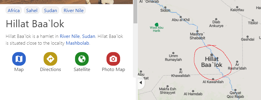
- Baaluk/Hillat Baa'lok
bali.png

baluk.png

Fashoda-4.jpg
 

Attachments

  • jj.png
    jj.png
    842,9 KB · Views: 0
  • butana.png
    butana.png
    396,1 KB · Views: 0
  • gh.png
    gh.png
    685,1 KB · Views: 0
  • gg.png
    gg.png
    552,2 KB · Views: 0
  • but1.png
    but1.png
    1,6 MB · Views: 0
  • butf.png
    butf.png
    850,7 KB · Views: 0
Last edited:
  • 1
Reactions:
Proposal to add a new province Dar al-Atbara
The name of the province comes from the Atbara River
View attachment 1184389

This province includes the city of Gadarif and Mount Teawa located west of the city of Gadarif.
This region is inhabited by two Arab tribes, Shukria and Bawadra. Bawadra As a tribe may have ruled this area in 1337.
According to the Bawadra accounts, Saad is the son of Mak Mahmoud and the grandson of Mak Jasser, who ruled the Butana from Jabal Tawawa, and participated in the Funj alliance that eliminated the Christian state of Alwa.
It was a tribal territory that fell under the influence of the Funj sultans of Sennar in the 16th century . Hasan ibn Hassuna, grandson of a Maghrebi emigrant, established a patriarchal lordship in the Butana region dedicated to cattle breeding and the export of horses to the Sennar and other kingdoms; the lordship maintained a small army and a good number of slaves. Hasan died in 1664/1665 , and the Sega Nissaga continued to the front as vassals of Sennar. At the end of the 18th century with the disintegration of the Funj sultanate, the area passed into the hands of the Shukriyya tribe who became the dominant power in Bhutan.
Quote from the Arabic Facebook page:
Therefore, we find that the Al-Bawadra tribe is one of the ancient Sudanese tribes that is spread in different parts of Sudan, and the largest part of it is concentrated in eastern Sudan, and its history has not been recorded to the extent that allows many to know it comprehensively. It is one of the Arab tribes that inhabit the Butana region and is located north of Gedaref and New Halfa along the Atbara River. And on the Blue Nile in some areas to the east, from eastern Sennar to the outskirts of the capital, in villages distributed and sometimes mixed with other tribes. It is an Adnani tribe of Quraish whose lineage goes back to the Messenger of God, may God bless him and grant him peace, and to the elite of the good people, our master Jaafar bin Abi Talib. It entered Sudan in the fourteenth century AD as part of the Arab migrations at that time.
The tribe's participation in the historic alliance organized by Abdullah Jama'a and Amara Dunqas and led by Sheikh Ajib Al-Manglik, the main ally of the Bawadara, to overthrow the Christian Kingdom of Alwa and establish the Funj Kingdom (1504 AD - 1821 AD). The Bawadra participated in the destruction of Suba Sharq, and then “Jasser,” the leader of the Bawadra, headed east to secure the unknown lands. After that, he was installed as the first “mek” of the Bawadra tribe by the Funj Kingdom through Al-Abdullab, so the Bawadra entered the city under the leadership of Mek Jasser until it became their exclusive property.

One of the nicknames given to Gedaref is Gedarof Saad. Some narrators believe that Saad is the name of a Coptic merchant who established the first store there, and nomads used to come to his store, so they gave Al-Qadarif in the beginning of its inception this name, while some attribute the character of Saad to other tribes such as Al-Shukriya, Al-Dabayna, and Al-Bawadra, all of which are among the groups that settled in the region, according to accounts. There are indications that Saad is the son of Al-Mak Mahmoud and the grandson of Al-Mak Jasir, who ruled the city from Mount Tawawa, and participated in the Funj alliance that eliminated the Christian state of Alwa.
View attachment 1184402
Atbara Province
-Teawa/Gadarif
- Mandera
- Bera
- Facher
All of the work you've done is great, the nile should get this kind of attention. When you feel your done I'd recommend you compile it into one proposal for the devs, because it is a bit hard to follow all of these individual posts, especially when the devs don't seem to be looking at this TM much anymore, so having a single post for all of it would be good. Keep up the great work man!
 
  • 3Like
Reactions:
All of the work you've done is great, the nile should get this kind of attention. When you feel your done I'd recommend you compile it into one proposal for the devs, because it is a bit hard to follow all of these individual posts, especially when the devs don't seem to be looking at this TM much anymore, so having a single post for all of it would be good. Keep up the great work man!
Thanks. When I finish Nubia, I will do so.
 
  • 4Like
Reactions:
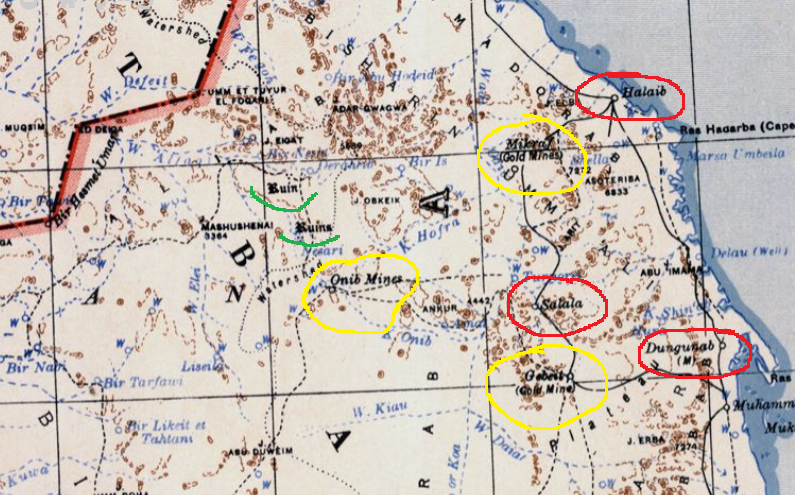
Proposal to add a new province Alaqi
This region is famous for mining gold and emeralds in 1337 this province should be controlled by the Emirate of Aswan of the Banu Kanz tribe. Unless there is evidence that Hadariba of ʿAydhab controls this province.

Aydhab
Map of Wadi Allaqi 1904
allla.png

gold.png

lk.png

hj.png

hj1.png

hj2.png


Zrzut ekranu 2025-01-11 160331.png

Allaqi Province
-Murrat
-Abu Tabag
- Deraheib
- Onib
- Salalah
- Gebest
1939
wad gab.png

Onib-Gebeit.png

Mikraf.png

sal.png
 
Last edited:
  • 2Like
Reactions:
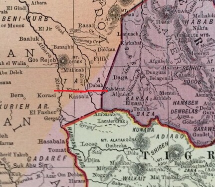
Proposal to add a new province Taka/Derkin
This region is inhabited by the Halenga Tribe which has a kingdom in this region. The kingdom is called Taka/Derkin. This kingdom is located in the delta of the Gash River, which is a very fertile region.
If this kingdom is added to the game, it should be called Taka and the Dynasty should be called Halenga.
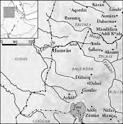
Below the Halenga tribe is the Hamran tribe, which is the Arabic-speaking Beja tribe.
Halenga, Hamran,Mazaga and
Artega are mixed tribes, they were created from unions of Arab and Beja tribes, these tribes are called Gabail Ukhra.
In the current map configuration, the locations in this region have a Sudanese Arab culture, this culture should be changed to Beja culture.
Halenga.png
Derkin2.png
Derkin1.jpg
Taka.jpg
Derkin-Taka.jpg

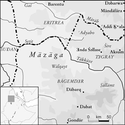
Division into two regions Derkin and Taka. Taka is the name of the mountain region located near the city of Kassala and Derkin is the name of the kingdom adopted as the name of the region between the Atbara River and the Gash River.
Derkin-Taka-Mazaga.jpg
Quote from wikipedia:
Along the Atbara and the adjacent Gash Delta (near Kassala) many Christian sites have been noted.[34] According to Ibn Hawqal, a vassal king loyal to Alodia governed the region around the Gash Delta.

The kingdom was divided into several provinces under the sovereignty of Soba.[157] It seems delegates of the king governed these provinces.[152] Al-Aswani stated that the governor of the northern al-Abwab province was appointed by the king.[158] This was similar to what Ibn Hawqal recorded for the Gash Delta region, which was ruled by an appointed Arabophone (Arabic speaker).[35] In 1286, Mamluk emissaries were sent to several rulers in central Sudan. It is unclear whether those rulers were actually independent,[77] or if they remained subordinate to the king of Alodia. If the latter was the case, this would provide an understanding of the kingdom's territorial organization. The "Sahib" of al-Abwab[92] seems certain to have been independent.[90] Apart from al-Abwab, the following regions are mentioned: Al-Anag (possibly Fazughli); Ari; Barah; Befal; Danfou; Kedru (possibly after Kadero, a village north of Khartoum); Kersa (the Gezira); and Taka (the region around the Gash Delta).[159]

No information was received about the Deccan kingdom after the traveler and geographer Ibn Hawqal referred to its existence in the tenth century AD (Picture of the Land in Massad, Sudanese Library, p. 74), and Ibn Hawqal did not mention anything about its founders in the region of Tiflin or Baqlin in the delta of the Gash Valley, as Al-Yaqoubi did ( Al-Ya’qubi’s History in Massad, p. 22) by him in the ninth century AD, who described the kingdom as vast and many cities, and we discussed this in our previous articles on the history and heritage of the Upper Blue Nile before the establishment of the Funj state in the weekly issue of Al-Sudani newspaper and the Sudanile website.

A few years after the era of Ibn Hawqal, Ibn Sulaym wrote (Akhbar al-Nuba fi Mustafa Massad, p. 100) while talking about the Nile, and he said: “The Nile diverges from this side into seven rivers, from which there is a river that comes from the east, as the water dries up in the summer until its stomach calms. If the time of the increase of the Nile came in it, and the ponds in it increased, and the rain and torrents came in the rest of the country, and the increase occurred in the Nile.” Ibn Sulaym added about this river, “It has a gender that is born between Al-Alwa and Al-Beja, they are called: Dijon.”

It is clear that Ibn Salim talks about the Atbara River, and that the Dijians are the inhabitants of the Deccan region, the delta of the Gash Valley, where the Deccan kingdom was established. However, Ibn Salim did not provide us with information about the inhabitants of the kingdom, which appears to have been at that time (10th century AD) extending south to the Atbara River.

The Arab sources have been silent about mentioning the Deccan kingdom since the era of Ibn Sulaym in the fourth century AH (10 AD) until the eighth century AH (14 AD), and we do not know anything about the conditions of the kingdom in that period. However, it is clear from later writings that its rule of the region continued until the nineteenth century. It seems that the name of the Deccan was no longer known or popular in Egypt after the tenth century AD, so the kingdom appeared under the name of the Taka.

Crawford (p. 96) quoted his sources as saying that the name Al-Taka was known in the region since ancient times, and mentioned that it was mentioned in the famous document of the port of Adulus (Adoli) in the second century BC. I reviewed the document in William Vincnt's The Commerce and Navigatin of the Ancients in the Indian Ocean Vol. 2 p33 - 543 quoted from Kosos' Topographia Chiristiana, written in the villages of the sixth century AD, but I have not found the name of the taka among the names mentioned in the area.

But Crawford linked the area to the people whom Pliny mentioned in the first century AD the Mathetae and whose name may still be living in the Mitatib name north of Aroma and in the Temitatei scheme on the Atbara river north of Goz Rajab. Many indications have indicated that the Taka region, the Gash Delta or the Deccan witnessed human settlements that contributed to the early cultures and civilizations of Sudan since the third millennium BC, such as the civilizations of Wadi Baraka, Jabal Makram and the civilization group c.

Therefore, the emergence of the name of the Taka in the ancient monuments is not excluded. It seems that the first mention of the name of the Taka in Arabic sources came to Ibn Sa`id al-Maghribi, who died in 1285 AD in his book (Geography, Al-Warraq website c. And in the west of Suakin, on the Nile of Abyssinia, the land of Al-Bakkah [Al-Taka], and they are the brothers of Abyssinia who are on this Nile.” And the Nile here is meant by the Atbara River.

Then the name of the Taka came among the Sudanese kingdoms, to which the Mamluk Sultan Al Mansour Qalawun sent his embassy in 1285 AD. Ibn Abd al-Zahir (Honoring Days and Ages in the biography of King al-Nasour in Mustafa Massad, Sudanese Library pg. 197) mentioned that the Sultan sent “Prince Alam al-Din Sanjar al-Ma’adami, a messenger to the king of Nubia, Adar, the king of doors, to the owner of Bara, to the owner of the Taka, to the owner of Kadro, and to the owner of Danfua, and to the owner of the Show me and to the owner of the vale and to the owner of the ang and to the owner of the chair...”

And the word “saheb” mentioned in the text, like “the owner of the taka,” means a ruler or a king. Historians have not yet agreed on the locations of most of the regions or kingdoms mentioned in the text. But the location of the taka is well known and there is no dispute over it, which is the area of the Gash delta, i.e. the location of the kingdom of the Deccan, and the meaning of the word taka itself means water flowing in multiple streams, as mentioned by Crawford. (The Fung Kingdom of Sennar, p. 114) This refers to the flow and dispersal of water in the Gash Delta region. As for Professor Muhammad Adroub Muhammad, an expert in the Beja language, he told me that taka in the Beja language means the area of the Dom trees, because “T” t means a defining tool in the Beja language, and “Ata means the Dom tree.” Fata or Taka means the Dom, meaning the area in which this is located. The tree.

Perhaps the disappearance of the name of the Deccan and the appearance of the name of the Deccan in the Arabic sources at the end of the thirteenth century - needs research and investigation, why and how the name of the Deccan replaced the name of the Deccan at a time when the term Deccan did not stop locally, but continued to be used until the nineteenth century, as will become clear in the following Layla?

Al-Halana and the Deccan/Taka Kingdom​

At the beginning of the fourteenth century, Al-Nuwari (Nahayat Al-Arb in Mus’ad, p. 234) indicated that the kingdom of the Taka was ruled by the Al-Halana tribe. He mentioned that the Mamluks sent an expedition to hunt down some of the Bedouins who raided a caravan in the eastern desert of Egypt. The expedition came to the port of Aizab, then entered the port of Suakin, and then moved south in search of the Bedouins until it reached “the land of the Taka, and they ended on the third day from the day they entered Kaslan [Kasala] … and this mountain is the border of the Taka country from Abyssinia…”

After describing the area, he stated that “dust appeared on them in front of them, so they sent for someone to reveal the news, so the scouts came back and told them that a group from the Sudan called the Helena had gathered to fight the military, and they were many people … by the Helenization of spears, batons and swords, and with some of them arrows … So the military killed them … So four hundred Helenas were killed. Sixty people were wounded and many of them were wounded… The soldiers were not able to capture them, for they thought killing was dearer to them than captivity, and two of their kings were killed according to what was told by those who met with them from the soldiers of the soldiers.”

This indicates that the Halaqa had a kingdom in the Al-Taka region in the fourteenth century AD, which is the same kingdom as the Takha to which the Mamluk embassy was sent at the end of the thirteenth century AD, and it is the same as the Islamic Deccan kingdom mentioned in the tenth century AD. The question that arises here is: When did the Halaqa tribe emerge as a leading force in the region, and what is their relationship to the Balu?

Ibn Hawqal did not mention the Al-Halana tribe among the major tribes in the region in the tenth century AD, which suggests that it will develop as a major power in the region after this century. As for the relationship of the halqa with the blue, the matter needs to be researched by those who are fluent in the Beja language and its heritage. However, I tend to the possibility of a relationship between the two groups, although we do not know the founders of the early Deccan kingdom, but it is not likely that they were the Halaqah, because their name did not appear among the major tribes mentioned by Ibn Hawqal in the region. It is most likely that if the Halaqa tribe had existed in the era of Ibn Hawqal, it must have been a small tribe that did not begin to contribute to the leadership of the region.

So, did the power of the Al-Halana tribe develop in the region at a later time to the tenth century AD and was able to reach the rule of the Deccan Kingdom or the Kingdom of the Taka as defined by Arab sources, and then the Balu tribe followed them in ruling the region? There is nothing to prevent this assumption, and another assumption can emerge, which is that the Balu were rulers of the Deccan kingdom, then the matter came to a family in the name of al-Halana from within the Balu tribe, because the Balu were scattered in the region and their name may have become a general name given to a number of Beja tribes. The Al-Halana family was able to rule the kingdom, succeeding the Balawi family, and the kingdom became famous by its name.
In any case, the Deccan kingdom was known in the Arab sources in the thirteenth and fourteenth centuries AD as the kingdom of al-Takha and the kingdom of al-Halqa. Then the names “The Deccan and the Blue” began to appear in the writings of European travelers in the sixteenth century AD. The name that was prevalent in the region for the queen is "the Deccan", and her kings became al-Buloo instead of al-Halqa. The people of the Belu were spread in all the regions of the current Beja from north to south, and even penetrated to the south? As it turns out? More than the current Peja spread.

And back to asking the questions, what happened to the authority of the Halaqa tribe in the fifteenth century? Were it weakened by the great transformations that occurred in the region since the end of the fourteenth century and the beginning of the fifteenth century AD? Among those transformations in the region are the emergence of some new leaderships that competed with the Blues, such as the Asjad and Bani Amer families.
hallanga.png


Halenga.png

Zrzut ekranu 2025-01-09 162516.png

Gash.png
Zrzut ekranu 2025-02-22 124330.png


Taka Province
-Adarama
Zrzut ekranu 2025-01-08 200358.png
- Goz Regeb
On the current map, this city is located in the Butana region, which is an incorrect location of this city. This city should be located on the right side of the Atbara River.
goz.png
- Filik
- Taka/Kassala
- Sebderat
- Aroma/Magauda

Hamran Province (The name of the Tribe that dominates this area)
- Wad al Hulaywah/Wad Heleiwa
- Tomat
- Abu Gamal
tomat.png

gamal.png

ham.png
 
Last edited:
  • 2
Reactions: