• We have updated our Community Code of Conduct. Please read through the new rules for the forum that are an integral part of Paradox Interactive’s User Agreement.

Tinto Maps #18 - 13th of September 2024 - Persia & Caucasus

Hello everyone, and welcome to one more Tinto Maps! Today we will be taking a look at Persia and the Caucasus! These are regions that encompass several modern-day countries and regions (Iraq, Iran, Balochistan, Afghanistan, Transoxiana, etc.), but for the sake of simplicity, we decided to name this DD this. Let’s start, without further ado!

Countries:
Countries.png

Colored Wastelands.png

The region is quite interesting in 1337, as there are plenty of countries to play with. The Ilkhanate is still alive, but in name only, the real power being hosted by the Jalayirids, who are overlords of some of their neighbors (the Chobanids, and the Eretnids). Other countries, such as Gurgan, the Kartids, and Muzaffarids are also struggling to get the hegemony over the region. Meanwhile, the strongest power in the Caucasus is the Kingdom of Georgia, although the region is also quite fragmented among different polities.

Ilkhanate.png

And speaking of the Ilkhanate, you may have wondered why isn’t it a unified tag… Well, it’s because we consider that it is clearly in decadence, having lost any grasp of authority over the provinces, so the best way of portraying it is through an International Organization. What we can see in this mapmode is that there are two pretenders to get the power, the Jalayarids and Gurgan, with the other countries still being formally part of it. I won’t talk more today about how it works and its features, but I’ll just say that there are two clear fates for the Ilkhanate: being dissolved, as historically happened, or being restored in full power as a unified country.

Dynasties:
Dynasties.png

Not much to say today about the dynasties, as they’re akin to the country names, in most cases. Well, you might wonder which one is the yellow one, ruling over Gurgan… That country is ruled by the Borgijin, heirs of Genghis Khan. Now you get the full picture of their rule over the Ilkhanate being challenged by the Jalayirids, I think…

Locations:
Locations.png

Location 2.png

Locations 3.png

Locations 4.png

Locations 5.png


Provinces:
Provinces.png


Areas:
Areas.png


Terrain:
Climate.png

Topography.png

Vegetation.png

We’re back to a region with lots of different climates, topography, and vegetation. This will make it very unique, gameplay and looking-wise.

Harbors:
Harbor.png

You might notice that there are ports in the Caspian Sea… Because, well, it’s considered a sea in our game, so there can be ships and navies over it.

Cultures:
Cultures.png

There's quite a lot of cultural division throughout the region... The Caucasus is, well, the Caucasus, divided among lots of different people. Then we have the Iraqi and Kurdish in Iraq, Persian and a number of other cultures in Iran, Baloch in Balochistan, Afghan in Afghanistan, and Khorasani, Turkmen, Khorezm, Hazara, and Tajiks, among others, in Khorasan and Transoxiana.

Religions:
Religion.png

Another interesting religious situation. Orthodox is the main religion in Georgia, and Miaphysitism in Armenia, with other confessions spread here and there throughout the Caucasus (Khabzeism, and three 'Pagan' confessions, Karachay-Balkar, Vainakh, and Lezgin). Then Iraq is divided among Sunni, to the north, and Shiism, to the south. And Iran is in an interesting situation, having a Sunni majority, but with some important Shiite pockets here and there. And Zoroastrianism, of course. It was not trivial to properly portray them, as we don't have good data for the 14th century. So what we did was some calculations, between sources that tell that there was still a majority as late as the 11th century, and the religion becoming severely reduced by the 16th century. Therefore, we decided to go with 20% of the population as a general rule of thumb; however, we're quite open to feedback over this matter.

Raw Materials:
Raw Materials.png

This region is full of rich resources, in stark contrast to the one we showed last week, Arabia. There are a couple of bugs on this mapmode that you might spot, I think.

Markets:
Markets.png

This region has several markets: Tabriz, Baghdad, Esfahan, Hormuz, Nishapur, and Zaranj., This will make for regionally fragmented-but-integrated economies (that is, good market access everyhwere, but with regionally diverging economies).

Population:
Population.png

Population 2.png

Population 3.png

Population 4.png

Population 5.png

The total population of the region is around 9M, taking into account all the different areas that we’re showing today. That is divided into about 4.5M in Iran, 2M in Iraq, 1.5M in the Caucasus, and around 1.5M in Transoxiana.

And that’s all for today! Next Friday we will be taking a look at India! Yes, in its entirety; we think that it is the best way to do it, although we’ll talk more about it next week. Another change, only for next week: the DD will be published at 10:00 instead of the regular 15:00, as I won’t be available in the afternoon to reply. Letting you know so there’s a proper wow-pole-run, yes. See you!
 

Attachments

  • Religion.png
    Religion.png
    3,2 MB · Views: 0
  • Cultures.png
    Cultures.png
    3,1 MB · Views: 0
  • 86Like
  • 86Love
  • 5
  • 3
  • 1Haha
  • 1
Reactions:


A couple additions to the map:
  • Expanded Samtskhe, vassal to Georgia
  • Kurds of Jalali, vassal to Jalayirids
  • Hamadan, vassal to Qasarids
  • Qom, vassal to Qasarids
  • Kashan, vassal to Qasarids
  • Merv, vassal to Kartids
  • Khaf, vassal to Kartids
  • Mongol tribe of Jurmanids, independent
  • Mongol tribe of Ughanids, independent
  • Kish, independent?

View attachment 1188529


View attachment 1188535
Out of curiosity, where'd you get the Sutayids owning Tortum?
 
The maps for Samtskhe show that it's not under them. And on the in-game map, the only other country with access to Tortum are the Sutayids, so I went with that
Did some looking. Given this (see the second to last footnote on page 184), it seems that it was controlled by a "Duchy of Tao". Also found the map for which the one on Wikipedia is based off of, and it seems that it still gives this territory to Georgia. I'd say it should belong to a new country, the Duchy of Tao, which at this point is still immediately subject to the Kingdom of Georgia but eventually is moved under Samtskhe.
 
  • 1
Reactions:
Thanks for the information, it's helpful.

Though I can't help but notice the bottom half of the quote. "from 1813, it remained the only military flotilla in the Caspian sea". And from the wiki link, with a size under 40 ships at its apex.
As a comparison, I would quote the American War of Independence and the British American War, which also saw limited navies (less than 30 of all sizes) battling over Lake Champlain. Yet, from the early provincial maps of the whole world we saw, I don't recall seeing "navigable lakes" with subdivision provinces in the dev diary ?
The British Are coming
Lake Champlain battle
40-30 ships is pretty substantial by eu4 standards. Especially since this represents a significant chunk of the Russian navy. Clearly, OTL Russia thought it was worth it to have a large fraction of their naval capacity devoted to the Volga-Caspian, even if you don't. I think I will take their word over yours.
3. In terms of AI ; and that's probably my biggest concern : will the AI be capable to understand when it's worth it and when it's not worth it anymore to develop a fleet in these waters. Woulnd't Russia put to much emphasis on this sea compared to the disadvantage of its other coastal defenses ? (Baltic / Black Sea / White Sea and Okhotshk sea, each one being relatively equivalent in terms of size / number of connected provinces). Wouldn't small central asian nations put to much emphasis on a navy, which would mean spending valuable coin for infrastructure / land army into a navy with limited interests outputs).
This kind of problem already exists in the game since it's the same thing as Egypt having to decide whether to build ships in the Mediterranean or Red Sea. And we already have mostly landlocked countries that can build fleets that don't really need them. In eu4, fleets are dirt cheap to maintain so it doesn't really matter, but I'm not sure how it will work in eu5.
 
  • 1Like
Reactions:
Did some looking. Given this (see the second to last footnote on page 184), it seems that it was controlled by a "Duchy of Tao". Also found the map for which the one on Wikipedia is based off of, and it seems that it still gives this territory to Georgia. I'd say it should belong to a new country, the Duchy of Tao, which at this point is still immediately subject to the Kingdom of Georgia but eventually is moved under Samtskhe.

I'll add Duchy of Tao then


  • 1
Reactions:
I'll add Duchy of Tao then


Either that or just give it to Georgia. I don't know how much autonomy the duchies of the Kingdom of Georgia had in this period, and whether they're better represented with a vassal subject or directly owned. My inclination is that it would be better owned by Georgia proper and represented with a powerful noble estate, but I can't say for sure.
 
Last edited:


On another note, I've drawn up a rough map of the tümen allocations of the Ilkhanate. Many of the nomadic peoples in these tümens were Turkics, hence don't take these tümens as being 100% made up of Mongols. However, from the Mongols that were there, we have little knowledge of their tribal affiliations, because tümens were more often than not mixed units. There would have been Mongols from multiple different tribes, from which the makeshift tribes such as the Jauni Kurban and several others were made up of.

However, I've written up the tribes we know of, or can assume to have been in the area based on the tribes of their commanders:
  • The Jalayirs and Suldus are very well known to have inhabited the central pastures of the empire in the Caucasus and Azerbaijan
    • 200,000, to 240,000 Nomads (Jalayir & Suldus Mongols and Turkics)
  • Ughan, from whom the Ughanids take their name, was a Jalayir minggan commander, so I've decided to mark them as Jalayirs, along with the Jurmanids, with whom they intermixed
    • 10,000, to 12,000 Jalayir Mongols
  • The descendants of Qasar went on to form the Khorchin tribe, and Qasar himself inherited people from the tribe of his mother, the Qonggirad, so I would assume his descendants in Khorasan are alike
    • 150,000, to 180,000 Nomads (Khorchin & Qonggirad Mongols and Turkics)
  • The Oirats had two different migratory paths upon entering the Middle East. To the West, to Eastern Anatolia, Diyarbakir and Mosul, under Buqa Temür. To the East, to Khorasan, under Arghun Aqa
    • West: 100,000, to 120,000 Nomads (Oirat Mongols and Turkics)
    • East: 100,000, to 120,000 Nomads (Oirat Mongols and Turkics)
  • The Hazaras and Moghols were likely descended from one of the Tümen assigned to the region
    • 50,000, to 60,000 Mongols
  • The Negüderis winter pasture is based in Ghazni
    • 50,000, to 60,000 Nomads (Mongols and Turkics, probably mixed with many others)
  • I couldn't find information on which tribes were in the tümen assigned to Kuhistan
    • 50,000 to 60,000 Nomads (Mongols and Turkics)
1 Tümen = 10,000 soldiers = 50,000 to 60,000 nomadic people
1 Minggan = 1000 soldiers = 5000 to 6000 nomadic people

Also note that since it has been 80 years from the time of the Mongol invasion, these populations would only have grown in size. Especially because they had annihilated hundreds of thousands of sedentary peoples and turned their lands into pastures.


Tümen distribution and rough cultures.png


Last edited:
  • 5Love
  • 3
  • 2Like
  • 1
Reactions:
The Negüderi are the southern part of the Qara'unas, as I mentioned in my details about Transoxiana, and so they can be folded in there.

The rest... I don't really know of a good way for present game mechanics to represent these, honestly.
 
The Negüderi are the southern part of the Qara'unas, as I mentioned in my details about Transoxiana, and so they can be folded in there.

The rest... I don't really know of a good way for present game mechanics to represent these, honestly.

I'm just going off on an assumption that the general Mongol culture group would be split into different parts, some of them maybe coinciding with the ones I've listed. Mechanics wise, all of these people would be part of the tribesmen estate.

It would be fun if Paradox made tribesmen pops to be more suspectible to migrations, however
 
Last edited:
  • 1Like
Reactions:
The Negüderi are the southern part of the Qara'unas, as I mentioned in my details about Transoxiana, and so they can be folded in there.

The rest... I don't really know of a good way for present game mechanics to represent these, honestly.
Weren't army based countries added to the game to represent this exact kind of thing?
 
Weren't army based countries added to the game to represent this exact kind of thing?
They are. I suppose to me it just seems a bit odd since they're not really holding any actual territory (most of them; the Qara'unas are very much actually holding territory). They're an ABC without land, and not really inherently settling down in that sort of land-owning way.

I suppose it can work. It really just depends on how an unlanded ABC plays.

The real odd one is figuring out whether it's coherently possible to have the Qara Qoyunlu, after becoming unlanded, wander over to India and conquer Golconda.


Island of Kish:

"Denise Aigle, Le Fārs sous la domination mongole: Politique et fiscalité (XIIIe–XIVes.)"
Review by David Durand-Guedy, The International Journal of Asian Studies. (2009):

View attachment 1188467


"The Mission of Malik Fakhruddin Ahmad Ṭībī to the Court of the Mongols in China" (2022):

View attachment 1188468


Kish was conquered by Hormuz in the 1320s

Screenshot_20240917-074403.png

 
  • 3Like
Reactions:
Suggestions for the next Tinto maps:
1. Map mode that showcases building-based countries
2. Map mode that shows which countries are settled and which are ABCs
3. Map mode that displays which locations are rural, which are towns, and which are cities. (I suppose that's technically covered by the specific population map, but I dont think it's always the case that "big population = higher settlement level")
4. Map mode showing roads and infrastructure (especially considering that's what the next TT is going to be focusing on)


None of those are really necessary, but I think they would greatly enhance our ability to give feedback and would be nice information to have in general, especially the first one.
 
  • 4Like
Reactions:
Does the Ilkhanate IO always collapse or centralize, or is there a possibility of HRE like situation where it stays as an IO with limited influence on members
 
  • 2Like
  • 1
Reactions:
Does the Ilkhanate IO always collapse or centralize, or is there a possibility of HRE like situation where it stays as an IO with limited influence on members


Honestly I would prefer it this way. Even if one of the (four) claimants managed to take charge, the peripheries of the Empire are still slipping, and Southern Iran has always had high autonomy. So victory in the succession wars doesn't immediately result in the centralization of the Empire, other than the consolidations of the locations of the ever important pastures and their tümens (nomadic military units and their Mongol commanders, on which the power of the Ilkhans rested).

The unification of the Ilkhanate should function something like the Shogunate in EU4, tied to the military sttength of the Ilkhan. Just because you took charge in Kyoto, doesn't mean the country is centralized now, and someone else might still try their luck at Imperial power, or independence.

Fits well with the theme of the Army-Based-Countries, whose existence is relied on their army, which all the four claimants are


Last edited:
  • 3Like
Reactions:
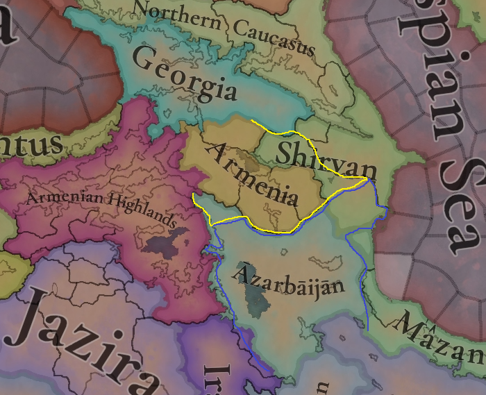
The Mughan plain should be part of the Azarbaijan area
The city of Maku should be part of the Area of Armenia. During the rule of the Safavids, this city was part of the province of Erivan / Chokhur-e Sa'd, i.e. Iranian Armenia.
The Kura River marked the borders of the Iranian province of Erivan
The city of Maku was the capital of the Artaz province ruled by the Armenian Amatuni (Artazian) family. In 1337 this province should have been dominated by the Armenian population.
I don't know what the status of this province was in 1337, but it was definitely part of Zakarid Armeni. It was ruled by the Amatuni family.
The Artazian branch of Amatuni family was ruling castle of Maku (Shavarshan) stil in XVth century and successfully defend it during Timurleng invasion, when he besieged castle of Maku, as was stated in his book by Castilian diplomat don Ruy González de Clavijo, when he was traveling to the imperial court of emir Timurleng in Samarkand.
A branch of the family still controlled a fiefdom of Artaz in Maku down to the 1500s when Ottomans and Kurdish tribes toppled Armenian rule in the region.
Artaz was a district in the northeast of Vaspurakan , whose capital was Maku . It bordered to the north with the Kogovit and the Masiatsun ; to the east with the Artaxes river that separated it from the district of Nakhjavan ( Nakhichevan ); to the south with the Djuash ; and to the west, with Mardastan and Thornavan . It was formed by the Tghmut river valley.

In the 13th and 14th centuries , under the name of Vaixútides(Vachutians)
, the Amatuní appear as princes of Aragatsotn , Siracene and Nig , with the great castle of Anberd. They were then vassals of the Armenian-Georgian Mkhargrdzelis of Northern Armenia.
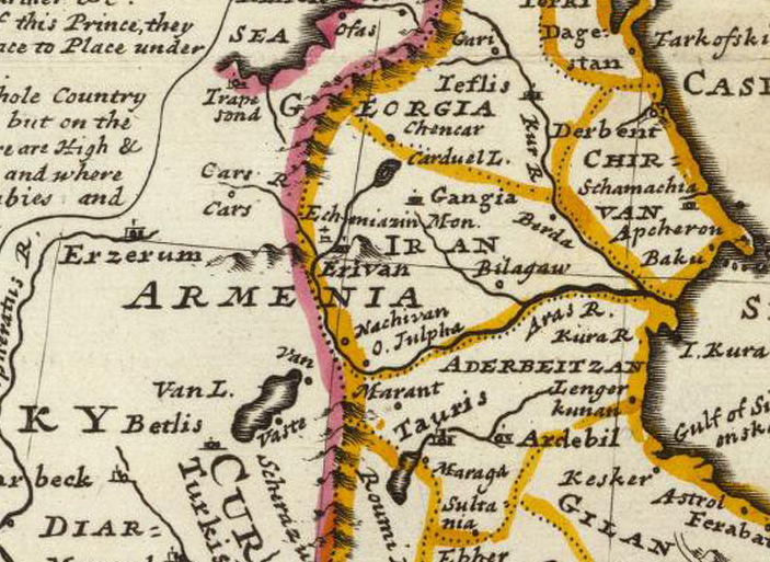
Artaz Province on an old map.
ARTAZ_L'_EMPIRE_De_PERSE_1779_d’Anville_P.Santini_~3.jpg

Areas.png

It seems that the Zakarid Armenia in 1337 should have been divided. The northern lands should have been under the control of the Zakarids and the southern ones should have been under the rule of the Vachutian and Proshyan dynasties.
I think the name of the kingdom of Armenia should be changed to the kingdom of Ani.

In their capital city of Ani, they named themselves the “Kings of Ani” exemplifying their independent ambitions from the Kings of Georgia.

As for the Province of Tashir(Lori-Somkheti), it appears that the Zakarid Dynasty rules it in 1337.
Or the Avanian Dynasty dependent on Zakarid.

During their victorious counter-offensive against the Muslim forces of the "Shah Armen", during what is commonly called the " Georgian Crusade ", the armies of the Kingdom of Georgia temporarily occupied under David IV of Georgia and then permanently from the reign of George III of Georgia part of the former Armenian Bagratid kingdoms , notably that of Lor(r)i 1 , 2 .
This territory which allowed the Bagrations of Georgia to grant themselves the title of "king of Armenia", which they would henceforth add to their royal titulary 3 , was given as a fief to Georgian or Armenian feudal lords under the name of the principality of "Lori-Somkhéti", " Somkhéti (სომხეთი)" meaning Armenia in Georgian .
After the disappearance of Zakarid Armenia to which it was incorporated, the principality of "Lori-Somkheti" was controlled by Armenian dynasts of the Avanian family, called by Cyril Toumanoff "Haykides-Avanides", princes of Dizak and Varanda 4 , descended from the princes of Khatchen . Following the invasions of the Turcomans in the 15th century , the Avanides governed the remains of the principality with the simple title of "melik" until the annexation in 1783 to the kingdom of Karthli - Kakheti by Heraclius II of Georgia .
In the 13th century, Shamkhor, along with other regions of northern and eastern Armenia, was conquered by the Mongols [ 16 ] [ 17 ] . In 1235, the Mongols destroyed it [ 15 ] . At that time, the city of Shamkir was in the possession of Vahram Gagetsi, the nephew of the ruler of the Zakarid principality Ivane Mkhargrdzeli (Zakarian) [ 16 ] . Vahram and his son Aghbugha were in Gardman during the Mongol siege and refused to help the inhabitants of the city despite their calls [ 18 ] . After conquering the region, the Mongols formed a special " Gurjistan Vilayet" (Georgian Province) , which consisted of eight tumans . According to Oxford University doctor Bayarsayhan Dashdondog, “three tumans were Armenian, namely: the lands of the Zakarids of Ani and Kars , the Avagids in Syunik and Artsakh , and the Vahramids (Vahramians)(Gagh, Shamkor and the surrounding area)”

Vahramians Dynasty
The Vahramians dynasty is a branch of the Zakarid dynasty and could probably have survived until 1337, although the last mention of them dates back to 1284.
It is best to give these lands to the Zakarid dynasty

The Vahramians , a princely house in medieval Armenia, operated in the years 1190 - 1300 , were commanders-siders of the Vahramian principality, partially or completely suzerain owners of Dzorapor, Tavush , Parisos, Gardman provinces, bore the title of prince-ruler

Limits of Vahramyans' domain

The domain of the Vahramians was formed in the years 1190 - 1200 . The borders of the empire stretched from the fortress of Gag to Shamkor , from Kur to Sevan mountains. Gag, Gavazan (Gavartsin), Katzaret , Yergevank, Tavush , Terunakan, Sazim, Karherdz, Gardman fortresses, Shamkor city were located in this area . The capital was Gag, the spiritual center was Nor Varagavank . A part of the commercial highway Partav - Gandzak - Shamkor - Tiflis passed through the border of the authority . The Kyurik principalities of Matznaberd and Nor Berd were in vassal dependence from the Vahramians .

Pedigree

The Vahramians belonged to the younger branch of the Zakarian dynasty. They are descended from Vahram A, the brother of Amirspasalar Sargis Zakaryan, after whom the clan got the name Vahramyanner. Vahram I died before 1176 . He had small estates in Debed valley.

Blauz Zakare I, liberating the Armenian provinces from the rule of the Yeltkuzyan Atabek of Gandzak , founded the Vahramian principality. He was succeeded by his son, Vahram B Gagetsi. In 1212 / 1213 , he was appointed maskhurtuchutes of the kingdom of Georgia /corresponds to the position of chamberlain/. Endowed with military and administrative abilities, he played a major role in the political life of the country and in the fight against foreign conquerors. He was especially distinguished during the exploratory expedition of the Mongols in 1220 - 1221 and during the organized resistance against Jalal ed din's gangs in 1225 - 1231 . In 1236 , in order to protect his principality from destruction, he accepted the rule of the Mongols and was recognized as the head of his principality, which turned into a "fog" (about 400 thousand inhabitants). In the 1240s , together with his son Aghbugha, he participated in the Mongol raids to Southern Armenia . In the years 1245 - 1247, Vahram B Gagetsi played a decisive role in raising George Lasha's son Davt to the East Georgian throne, and in 1249 he participated in the Armenian-Georgian rebellion against the Mongols. Vahram B was succeeded by Agbugha. During his reign, the power of the Vahramians began to weaken. In the second half of the 13th century, Aghbugha was succeeded by his sons: Vahram G, Zakare B, Ivane. The last information about the Vahramians dates back to 1284 .

armenia.png
 
Last edited:
  • 6Like
  • 1
Reactions:
I think the name of the kingdom of Armenia should be changed to the kingdom of Ani.

In their capital city of Ani, they named themselves the “Kings of Ani” exemplifying their independent ambitions from the Kings of Georgia.
In Project Caesar, names are dynamic, and as Armenia starts as a subject to Georgia, they should start just as "Armenia", later being elevated to kingship if they become independent.

After conquering the region, the Mongols formed a special " Gurjistan Vilayet" (Georgian Province) , which consisted of eight tumans . According to Oxford University doctor Bayarsayhan Dashdondog, “three tumans were Armenian, namely: the lands of the Zakarids of Ani and Kars , the Avagids in Syunik and Artsakh , and the Vahramids (Vahramians)(Gagh, Shamkor and the surrounding area)”
I think this is a similar problem we faced in the Carpathia/Balkans dev diary, where Transylvania could be represented as a vassal, but wasn't due to gameplay reasons. Georgia already should have a massive vassal in the form of Samtskhe, and adding 3 more would probably be unwise.
 
  • 4
Reactions:
In Project Caesar, names are dynamic, and as Armenia starts as a subject to Georgia, they should start just as "Armenia", later being elevated to kingship if they become independent.


I think this is a similar problem we faced in the Carpathia/Balkans dev diary, where Transylvania could be represented as a vassal, but wasn't due to gameplay reasons. Georgia already should have a massive vassal in the form of Samtskhe, and adding 3 more would probably be unwise.

Armenia starting as vassal to Georgia is definitely debatable. Mentions of their relationship and obligations to the Mongols leans much more towards being their vassals, rather than Georgia. Georgia broke free a decade ago, but no mention of Armenia.
 
  • 2Like
Reactions: