• We have updated our Community Code of Conduct. Please read through the new rules for the forum that are an integral part of Paradox Interactive’s User Agreement.

Tinto Maps #18 - 13th of September 2024 - Persia & Caucasus

Hello everyone, and welcome to one more Tinto Maps! Today we will be taking a look at Persia and the Caucasus! These are regions that encompass several modern-day countries and regions (Iraq, Iran, Balochistan, Afghanistan, Transoxiana, etc.), but for the sake of simplicity, we decided to name this DD this. Let’s start, without further ado!

Countries:
Countries.png

Colored Wastelands.png

The region is quite interesting in 1337, as there are plenty of countries to play with. The Ilkhanate is still alive, but in name only, the real power being hosted by the Jalayirids, who are overlords of some of their neighbors (the Chobanids, and the Eretnids). Other countries, such as Gurgan, the Kartids, and Muzaffarids are also struggling to get the hegemony over the region. Meanwhile, the strongest power in the Caucasus is the Kingdom of Georgia, although the region is also quite fragmented among different polities.

Ilkhanate.png

And speaking of the Ilkhanate, you may have wondered why isn’t it a unified tag… Well, it’s because we consider that it is clearly in decadence, having lost any grasp of authority over the provinces, so the best way of portraying it is through an International Organization. What we can see in this mapmode is that there are two pretenders to get the power, the Jalayarids and Gurgan, with the other countries still being formally part of it. I won’t talk more today about how it works and its features, but I’ll just say that there are two clear fates for the Ilkhanate: being dissolved, as historically happened, or being restored in full power as a unified country.

Dynasties:
Dynasties.png

Not much to say today about the dynasties, as they’re akin to the country names, in most cases. Well, you might wonder which one is the yellow one, ruling over Gurgan… That country is ruled by the Borgijin, heirs of Genghis Khan. Now you get the full picture of their rule over the Ilkhanate being challenged by the Jalayirids, I think…

Locations:
Locations.png

Location 2.png

Locations 3.png

Locations 4.png

Locations 5.png


Provinces:
Provinces.png


Areas:
Areas.png


Terrain:
Climate.png

Topography.png

Vegetation.png

We’re back to a region with lots of different climates, topography, and vegetation. This will make it very unique, gameplay and looking-wise.

Harbors:
Harbor.png

You might notice that there are ports in the Caspian Sea… Because, well, it’s considered a sea in our game, so there can be ships and navies over it.

Cultures:
Cultures.png

There's quite a lot of cultural division throughout the region... The Caucasus is, well, the Caucasus, divided among lots of different people. Then we have the Iraqi and Kurdish in Iraq, Persian and a number of other cultures in Iran, Baloch in Balochistan, Afghan in Afghanistan, and Khorasani, Turkmen, Khorezm, Hazara, and Tajiks, among others, in Khorasan and Transoxiana.

Religions:
Religion.png

Another interesting religious situation. Orthodox is the main religion in Georgia, and Miaphysitism in Armenia, with other confessions spread here and there throughout the Caucasus (Khabzeism, and three 'Pagan' confessions, Karachay-Balkar, Vainakh, and Lezgin). Then Iraq is divided among Sunni, to the north, and Shiism, to the south. And Iran is in an interesting situation, having a Sunni majority, but with some important Shiite pockets here and there. And Zoroastrianism, of course. It was not trivial to properly portray them, as we don't have good data for the 14th century. So what we did was some calculations, between sources that tell that there was still a majority as late as the 11th century, and the religion becoming severely reduced by the 16th century. Therefore, we decided to go with 20% of the population as a general rule of thumb; however, we're quite open to feedback over this matter.

Raw Materials:
Raw Materials.png

This region is full of rich resources, in stark contrast to the one we showed last week, Arabia. There are a couple of bugs on this mapmode that you might spot, I think.

Markets:
Markets.png

This region has several markets: Tabriz, Baghdad, Esfahan, Hormuz, Nishapur, and Zaranj., This will make for regionally fragmented-but-integrated economies (that is, good market access everyhwere, but with regionally diverging economies).

Population:
Population.png

Population 2.png

Population 3.png

Population 4.png

Population 5.png

The total population of the region is around 9M, taking into account all the different areas that we’re showing today. That is divided into about 4.5M in Iran, 2M in Iraq, 1.5M in the Caucasus, and around 1.5M in Transoxiana.

And that’s all for today! Next Friday we will be taking a look at India! Yes, in its entirety; we think that it is the best way to do it, although we’ll talk more about it next week. Another change, only for next week: the DD will be published at 10:00 instead of the regular 15:00, as I won’t be available in the afternoon to reply. Letting you know so there’s a proper wow-pole-run, yes. See you!
 

Attachments

  • Religion.png
    Religion.png
    3,2 MB · Views: 0
  • Cultures.png
    Cultures.png
    3,1 MB · Views: 0
  • 86Love
  • 84Like
  • 5
  • 3
  • 1Haha
  • 1
Reactions:
I feel like there's more stuff we're missing. Are we sure there were no vassals in that separated part of the Jalayirids on SuperLexxe's map? The area controlled by the Qasarids also looks kind of weird - I wonder if they really controlled all of it directly.
 
I feel like there's more stuff we're missing. Are we sure there were no vassals in that separated part of the Jalayirids on SuperLexxe's map? The area controlled by the Qasarids also looks kind of weird - I wonder if they really controlled all of it directly.

It's kind of hard to define what is and isn't a tag in Iran and the surrounds in this time because the whole area is effectively in a giant civil war with rapidly shifting allegiances. If the game were to start in 1335, there's a strong case to be made that the Il-Khanate should be a single unified tag still, with Abu Said in reasonable secure control of strong bureaucratic institutions and the lands of the Il-Khanate being relatively prosperous. Abu Said's death without a clear heir sent various factions trying to place puppets on the throne, but the conflict ended up going on for so long that it completely destroyed any unified institutions and sent the region spiralling into anarchy, which Timur will eventually clean up. Even then, Husayn Gurkan at least nominally succeeded in placing Muhammad Khan on the throne and having that recognised everywhere short of Khorasan and if it wasn't for the shock victory of the Chobanids, we might all be sitting here arguing that the Il-Khanate should be a single tag in 1337 with several active revolts on-going, rather than an IO.

It's very hard to say what should be done with many areas as a result, because events were moving so fast. A particular area might have aligned itself with Husayn Gurkan in 1337 and recognised his rule, then instantly switched over on his defeat. Does that mean it should be represented as Jalayrid territory? Or as a vassal of the Jalayrids? Or as an independent tag? How do you get it to switch over so swiftly to the Chobanids? These are very difficult questions and I don't think there are perfect answers.

In particular, you say "I wonder if they really controlled all of it directly", and the answer is "almost certainly not" - for much of this period, you controlled where your army was and not much more!
 
Last edited:
I feel like there's more stuff we're missing. Are we sure there were no vassals in that separated part of the Jalayirids on SuperLexxe's map? The area controlled by the Qasarids also looks kind of weird - I wonder if they really controlled all of it directly.


From what I know, having perused through about 15 books on this, there are no other tags that could be found to fill those holes. That is likely because those lands fall in direct with the suitable pastures, which were prime real estate for the Ilkhanate, and upon which their entire military and administration was based upon.

Another reason they look odd is because there is a civil war going on. The Khorasani army ran through Iraq-e-Ajam and took Soltaniyeh just as the game starts. Meanwhile the Jalayirids had driven Musa Khan south to Baghdad, but withdrew and didn't lay siege to the city. Musa Khan then made his way to Soltaniyeh to ally with Togha Temür.

It would only be after Musa Khan dies in battle 3 months later in June 1337, when the rest of Iraq submits to the Jalayirids, and when the Chobanids drive the Jalayirids out of Azerbaijan in July 1338, the Jalayirids would establish their new capital at Baghdad.


During this civil war, an occupation of a rival claimant's land is essentially an instant integration, rather than a conquest. Or at least that's how it should be, and that's how we can represent the swift rise of the Chobanids to #1 power in Iran in less than a year, and the unification of the Ilkhanate, without taking 500 AE.


Last edited:
  • 2Like
Reactions:
That and Kurdistan was, even with a fully unified Ilkhanate, always this sorta "area which was worked around". It might seem odd to have that divide between Baghdad and Tabriz, but there's a reason why the Ottomans and the Safavids ultimately had that as their border.

There's a reason why it's only really the semi-nomadic conquerors that managed to build states that exist on both sides of the Zagros, and even then never really controlled it.
I do wonder a bit whether Kurdistan might be better represented by a SoP rather than a series of tiny tags.
 
  • 1
Reactions:
I do wonder a bit whether Kurdistan might be better represented by a SoP rather than a series of tiny tags.


Besides the Kurds already being organized societies, turning them into SoPs would remove the "Kurdish Zone", which was essentially the diplomatic battlefield of the Mamluks and the Ilkhanate in trying to sway them to their side. Later they would be key pawns between the Ottomans and the Safavids, but also occasionally making their own, though limited, territorial overtures.


  • 1
  • 1Like
Reactions:


Besides the Kurds already being organized societies, turning them into SoPs would remove the "Kurdish Zone", which was essentially the diplomatic battlefield of the Mamluks and the Ilkhanate in trying to sway them to their side. Later they would be key pawns between the Ottomans and the Safavids, but also occasionally making their own, though limited, territorial overtures.


I think it depends how SoPs actually function in-game - we still don't really know yet and there's a lot of potential scope there. I don't have strong views on it until we have more detail, but I'm not for taking the idea off the table yet either.
 
  • 1
Reactions:
There's a reason why it's only really the semi-nomadic conquerors that managed to build states that exist on both sides of the Zagros, and even then never really controlled it.
The Medes, Achaemenids, Seleucids, Parthians, Sassanians, and Umayyads would like to have a word with you
 
  • 2Like
  • 2
Reactions:
It seems that the role of the capital of the principality of the Vachutians dynasty was taken over by Karbi

Zrzut ekranu 2025-03-15 120336.png

Zrzut ekranu 2025-03-15 120431.png

arm-yta.png

Talin city
Zrzut ekranu 2025-03-15 122510.png

Hovhannavank Monastery is located above the capital of the Vachutians, so the city of Amberd is not a property of the Alastani principality.
Zrzut ekranu 2025-03-15 125947.png

Zrzut ekranu 2025-03-15 130731.png
 
Last edited:
  • 2Like
  • 1
  • 1
Reactions:
It seems that the role of the capital of the principality of the Vachutians dynasty was taken over by Karbi

View attachment 1266323
View attachment 1266324
View attachment 1266369
View attachment 1266330
As for the fortress of Amberd which lies below Karbi, there are two roads leading to the fortress, with the natural barrier in the middle being the mountains, one road passes through the city of Karbi and the other through the city of Talin near the capital of the Zakarids, the question is which of these roads does the Alastani principality control?
View attachment 1266331
Hovhannavank Monastery is located above the capital of the Vachutians, so the city of Amberd is not a property of the Alastani principality.
View attachment 1266351
View attachment 1266366


My understanding is that Amberd "castle in the clouds" is located on the slopes of Mount Aragats, a fraction of a degree North-West of Karbi.

Amberd location: 40.3886°N, 44.2264°E
Karbi location: 40.3311°N, 44.3764°E


My understanding is that Amberd "castle in the clouds" is located on the slopes of Mount Aragats, a fraction of a degree North-West of Karbi.

Amberd location: 40.3886°N, 44.2264°E
Karbi location: 40.3311°N, 44.3764°E


It is as you say, my mistake.
Zrzut ekranu 2025-03-15 142112.png
 
It seems that the role of the capital of the principality of the Vachutians dynasty was taken over by Karbi

View attachment 1266323
View attachment 1266324
View attachment 1266363

View attachment 1266330
As for the fortress of Amberd which lies below Karbi, there are two roads leading to the fortress, with the natural barrier in the middle being the mountains, one road passes through the city of Karbi and the other through the city of Talin near the capital of the Zakarids, the question is which of these roads does the Alastani principality control?
View attachment 1266331
Hovhannavank Monastery is located above the capital of the Vachutians, so the city of Amberd is not a property of the Alastani principality.
View attachment 1266351
View attachment 1266366
Instead of citing unsourced websites and making random assertions about the geography of the region, why not actually read the source I provided?

I understand that the text is in Georgian, but straight-up ignoring my arguments is just dishonest.

The text clearly states that the land given to the Zakarids in Armenia proper was a fief mouvant, in no way legally differentiated from other lordships in Georgia. The land held by Shanshe II was revoked by David VIII and conceded to his children in the early 1300s. The location of the church is irrelevant here, as the inscription says that the entire region was held by them.

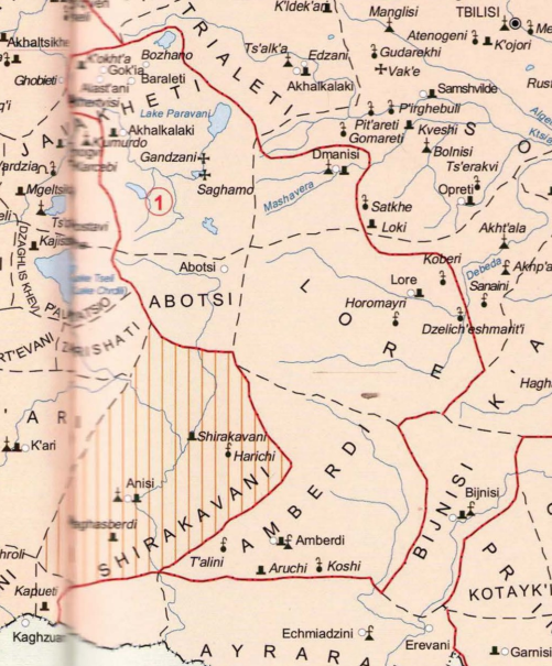
bro.png


The authorial interpretation of the text as represented in this map is very reasonable (hence the devs depicting the region as such in Johan's seismic activity map).


Anyway, I think we all know how messed up feudal borders can be, and the Alastani having been granted the majority of the land around Amberd, doesn't necessarily mean that the Vachutians did not control Amberd itself, or buy and restore it later (as the castle was in ruins).

It is simply that even with EU5 locations being as small as they are, they still aren't small enough to represent something like that.

Considering the information we have, it would be best to keep the land under Alastani, with Amberd having a core on it.


  • 1Like
Reactions:
Instead of citing unsourced websites and making random assertions about the geography of the region, why not actually read the source I provided?

I understand that the text is in Georgian, but straight-up ignoring my arguments is just dishonest.

The text clearly states that the land given to the Zakarids in Armenia proper was a fief mouvant, in no way legally differentiated from other lordships in Georgia. The land held by Shanshe II was revoked by David VIII and conceded to his children in the early 1300s. The location of the church is irrelevant here, as the inscription says that the entire region was held by them.

View attachment 1266395

The authorial interpretation of the text as represented in this map is very reasonable (hence the devs depicting the region as such in Johan's seismic activity map).

This church marks the border between the current capital of Vachutians and the Principality of Alastani. And I confused the location of Amberd Castle with the current city of Amberd in Armenia.
Which doesn't mean the castle isn't under Vachutians control.
 
  • 1
Reactions:
This church marks the border between the current capital of Vachutians and the Principality of Alastani.
Okay. Where did you get that information from? What is even known about that dynasty beyond a poorly sourced Wikipedia page and random obscure website?

Which doesn't mean the castle isn't under Vachutians control.
My brother in Christ, the castle was slighted by the Mongols 100 years ago.

The capital of the Alastani princes is in Lore.

The land grant is confirmed in epigraphic evidence.

Just because the church where this information is found is in a different place from the core of the territory doesn't mean the land wasn't held by them. This is the same exact fief granted to Zakare II by Tamar 150 years ago.

recvrdf.png


Stop being so stubborn and read the paper I provided.
 
  • 1
  • 1Like
Reactions:
I found the original pdf file that mentions Amberd.

G. Hovsepyan in his work “Khalbakyank or Prosheyank Hayotsamutyan med” notes: “The Karbi bell tower was built in 1338, the oldest inscription is by Kurd Anberdetsun, son of Tayir, which is unfinished and probably he was the one who built it himself” 23. Moreover, it is noteworthy that the Karbi bell tower was one of the first bell towers built in Armenia. Although the use of bells in the Christian church dates back to the seventh century, in Armenia, first due to the Arab and then Seljuk domination, their use, as well as the construction of bell towers as an architectural innovation, has a much later history and is associated with the revival of Armenia at the end of the 12th century, when thanks to the two Zakaryan brothers, the Seljuks were expelled from Armenia. The inscriptions on the bell tower of Karbi have served as an important starting point for studying the history of the Vachutyan dynasty, the princes of Aragatsotn, of which the powerful prince of the time, Kurd II of Amberd, was a favorite. One of the inscriptions on the bell tower confirms that during the lifetime of Kurd II, his son was the lord of Amberd. Kurd II formulated it this way: “and my dear son, our Cherkin, lord of the Amber-doy province” 24. Of great interest is the inscription of Theodosius, carved on the southern wall of the Karbi bell tower, on the outside in 1343. In this inscription, Cherkin states: "I, Chrkins, son of Kurd, lord of the Amberd province, saw it as unjust that they should give a horse-drawn carriage to a traveler, and we wrote this edict so that no more horse-drawn carriages would be given to travelers in the Carpathians." With this edict, Theodosius abolished the horse-drawn carriage, the carriage of messengers, travelers, and tax collectors on horseback, food, and food in the princely state.
Zrzut ekranu 2025-03-15 174150.png

Zrzut ekranu 2025-03-15 174414.png
 
  • 1
  • 1Like
Reactions:
I found the original pdf file that mentions Amberd.

G. Hovsepyan in his work “Khalbakyank or Prosheyank Hayotsamutyan med” notes: “The Karbi bell tower was built in 1338, the oldest inscription is by Kurd Anberdetsun, son of Tayir, which is unfinished and probably he was the one who built it himself” 23. Moreover, it is noteworthy that the Karbi bell tower was one of the first bell towers built in Armenia. Although the use of bells in the Christian church dates back to the seventh century, in Armenia, first due to the Arab and then Seljuk domination, their use, as well as the construction of bell towers as an architectural innovation, has a much later history and is associated with the revival of Armenia at the end of the 12th century, when thanks to the two Zakaryan brothers, the Seljuks were expelled from Armenia. The inscriptions on the bell tower of Karbi have served as an important starting point for studying the history of the Vachutyan dynasty, the princes of Aragatsotn, of which the powerful prince of the time, Kurd II of Amberd, was a favorite. One of the inscriptions on the bell tower confirms that during the lifetime of Kurd II, his son was the lord of Amberd. Kurd II formulated it this way: “and my dear son, our Cherkin, lord of the Amber-doy province” 24. Of great interest is the inscription of Theodosius, carved on the southern wall of the Karbi bell tower, on the outside in 1343. In this inscription, Cherkin states: "I, Chrkins, son of Kurd, lord of the Amberd province, saw it as unjust that they should give a horse-drawn carriage to a traveler, and we wrote this edict so that no more horse-drawn carriages would be given to travelers in the Carpathians." With this edict, Theodosius abolished the horse-drawn carriage, the carriage of messengers, travelers, and tax collectors on horseback, food, and food in the princely state.
View attachment 1266485
View attachment 1266496


Considering this has direct reference to Amberd, it looks like it is most accurate to place Amberd under the Vachutians.


  • 1Like
Reactions:
I found the original pdf file that mentions Amberd.

G. Hovsepyan in his work “Khalbakyank or Prosheyank Hayotsamutyan med” notes: “The Karbi bell tower was built in 1338, the oldest inscription is by Kurd Anberdetsun, son of Tayir, which is unfinished and probably he was the one who built it himself” 23. Moreover, it is noteworthy that the Karbi bell tower was one of the first bell towers built in Armenia. Although the use of bells in the Christian church dates back to the seventh century, in Armenia, first due to the Arab and then Seljuk domination, their use, as well as the construction of bell towers as an architectural innovation, has a much later history and is associated with the revival of Armenia at the end of the 12th century, when thanks to the two Zakaryan brothers, the Seljuks were expelled from Armenia. The inscriptions on the bell tower of Karbi have served as an important starting point for studying the history of the Vachutyan dynasty, the princes of Aragatsotn, of which the powerful prince of the time, Kurd II of Amberd, was a favorite. One of the inscriptions on the bell tower confirms that during the lifetime of Kurd II, his son was the lord of Amberd. Kurd II formulated it this way: “and my dear son, our Cherkin, lord of the Amber-doy province” 24. Of great interest is the inscription of Theodosius, carved on the southern wall of the Karbi bell tower, on the outside in 1343. In this inscription, Cherkin states: "I, Chrkins, son of Kurd, lord of the Amberd province, saw it as unjust that they should give a horse-drawn carriage to a traveler, and we wrote this edict so that no more horse-drawn carriages would be given to travelers in the Carpathians." With this edict, Theodosius abolished the horse-drawn carriage, the carriage of messengers, travelers, and tax collectors on horseback, food, and food in the princely state.
View attachment 1266485
View attachment 1266496
Assuming the information is correct here, this just means that this person was a claimant to the title. As per the royal decree, the land belonged to the Alastanians.

Apply your own line of thinking to this information. You said that the Alastanis only owned Hovhannavank, since that's where the inscriptions are and nothing more around it. By this logic, they would have only owned Karbi, no?
 
  • 1Like
Reactions:
Assuming the information is correct here, this just means that this person was a claimant to the title. As per the royal decree, the land belonged to the Alastanians.

Apply your own line of thinking to this information. You said that the Alastanis only owned Hovhannavank, since that's where the inscriptions are and nothing more around it. By this logic, they would have only owned Karbi, no?
Only that in this text both father and son use this title, it refers to both the castle and the province of Amberd
Additionally, the borders of the Amberd province on your map include Karbi, the capital of Kurd II, which means that the Vachutians are still the masters of this land. Unless the map is wrong and the borders of this province should be placed a bit higher?

I don't want to argue endlessly about who has control over province Amberd, let's just give this location to the Vachutians dynasty. And the locations above to the Alastani Principality.
 
Last edited:
  • 1Like
Reactions:
Okay, I suppose the most reasonable decision would be to give the location of Amberd to a Vachutian OPM, while giving Artashavan to Alastani.

It's only through such a delineation which doesn't contradict what our sources tell us.

I don't want to argue endlessly about who has control over Amberd
You said it, mate.
 
Last edited: