• We have updated our Community Code of Conduct. Please read through the new rules for the forum that are an integral part of Paradox Interactive’s User Agreement.

Tinto Maps #18 - 13th of September 2024 - Persia & Caucasus

Hello everyone, and welcome to one more Tinto Maps! Today we will be taking a look at Persia and the Caucasus! These are regions that encompass several modern-day countries and regions (Iraq, Iran, Balochistan, Afghanistan, Transoxiana, etc.), but for the sake of simplicity, we decided to name this DD this. Let’s start, without further ado!

Countries:
Countries.png

Colored Wastelands.png

The region is quite interesting in 1337, as there are plenty of countries to play with. The Ilkhanate is still alive, but in name only, the real power being hosted by the Jalayirids, who are overlords of some of their neighbors (the Chobanids, and the Eretnids). Other countries, such as Gurgan, the Kartids, and Muzaffarids are also struggling to get the hegemony over the region. Meanwhile, the strongest power in the Caucasus is the Kingdom of Georgia, although the region is also quite fragmented among different polities.

Ilkhanate.png

And speaking of the Ilkhanate, you may have wondered why isn’t it a unified tag… Well, it’s because we consider that it is clearly in decadence, having lost any grasp of authority over the provinces, so the best way of portraying it is through an International Organization. What we can see in this mapmode is that there are two pretenders to get the power, the Jalayarids and Gurgan, with the other countries still being formally part of it. I won’t talk more today about how it works and its features, but I’ll just say that there are two clear fates for the Ilkhanate: being dissolved, as historically happened, or being restored in full power as a unified country.

Dynasties:
Dynasties.png

Not much to say today about the dynasties, as they’re akin to the country names, in most cases. Well, you might wonder which one is the yellow one, ruling over Gurgan… That country is ruled by the Borgijin, heirs of Genghis Khan. Now you get the full picture of their rule over the Ilkhanate being challenged by the Jalayirids, I think…

Locations:
Locations.png

Location 2.png

Locations 3.png

Locations 4.png

Locations 5.png


Provinces:
Provinces.png


Areas:
Areas.png


Terrain:
Climate.png

Topography.png

Vegetation.png

We’re back to a region with lots of different climates, topography, and vegetation. This will make it very unique, gameplay and looking-wise.

Harbors:
Harbor.png

You might notice that there are ports in the Caspian Sea… Because, well, it’s considered a sea in our game, so there can be ships and navies over it.

Cultures:
Cultures.png

There's quite a lot of cultural division throughout the region... The Caucasus is, well, the Caucasus, divided among lots of different people. Then we have the Iraqi and Kurdish in Iraq, Persian and a number of other cultures in Iran, Baloch in Balochistan, Afghan in Afghanistan, and Khorasani, Turkmen, Khorezm, Hazara, and Tajiks, among others, in Khorasan and Transoxiana.

Religions:
Religion.png

Another interesting religious situation. Orthodox is the main religion in Georgia, and Miaphysitism in Armenia, with other confessions spread here and there throughout the Caucasus (Khabzeism, and three 'Pagan' confessions, Karachay-Balkar, Vainakh, and Lezgin). Then Iraq is divided among Sunni, to the north, and Shiism, to the south. And Iran is in an interesting situation, having a Sunni majority, but with some important Shiite pockets here and there. And Zoroastrianism, of course. It was not trivial to properly portray them, as we don't have good data for the 14th century. So what we did was some calculations, between sources that tell that there was still a majority as late as the 11th century, and the religion becoming severely reduced by the 16th century. Therefore, we decided to go with 20% of the population as a general rule of thumb; however, we're quite open to feedback over this matter.

Raw Materials:
Raw Materials.png

This region is full of rich resources, in stark contrast to the one we showed last week, Arabia. There are a couple of bugs on this mapmode that you might spot, I think.

Markets:
Markets.png

This region has several markets: Tabriz, Baghdad, Esfahan, Hormuz, Nishapur, and Zaranj., This will make for regionally fragmented-but-integrated economies (that is, good market access everyhwere, but with regionally diverging economies).

Population:
Population.png

Population 2.png

Population 3.png

Population 4.png

Population 5.png

The total population of the region is around 9M, taking into account all the different areas that we’re showing today. That is divided into about 4.5M in Iran, 2M in Iraq, 1.5M in the Caucasus, and around 1.5M in Transoxiana.

And that’s all for today! Next Friday we will be taking a look at India! Yes, in its entirety; we think that it is the best way to do it, although we’ll talk more about it next week. Another change, only for next week: the DD will be published at 10:00 instead of the regular 15:00, as I won’t be available in the afternoon to reply. Letting you know so there’s a proper wow-pole-run, yes. See you!
 

Attachments

  • Religion.png
    Religion.png
    3,2 MB · Views: 0
  • Cultures.png
    Cultures.png
    3,1 MB · Views: 0
  • 86Love
  • 84Like
  • 5
  • 3
  • 1Haha
  • 1
Reactions:
On the current map two new locations need to be added For the Dopian dynasty. Locations Tsar and Sotk.
Duchy of Ani may get new location Talin.
As for the Vachutian dynasty, I'm not sure if they should control the Igdir location.
aRMENIA.png

Nursu
Zrzut ekranu 2025-03-21 232958.png

Zrzut ekranu 2025-03-22 101014.png

Approximate borders of the principalities
ILKHANS AND ISHKHANS COINS OF THE ARMENIAN PRINCIPALITIES OF THE PERIOD OF THE DECLINE OF THE HULAGUID STATE (737-759 AH / 1336-1358 BC)
Zrzut ekranu 2025-03-21 200003.png

13th century.
Zrzut ekranu 2025-03-21 212444.png

 
Last edited:
  • 2
Reactions:
It seems that the regions of Rshtunik and Mokki are ruled by Armenians who should be vassals of the Mongols. The question is whether to present all three principalities or limit ourselves to just one ?
As for formable tags, these countries could recreate the kingdom of Vaspurakan if they are added to the game.
Such was the ambition of the Sephardim dynasty
1:Akdamar
2:Moks
3:Shatakh

Rshtunik​

Moxoene/Mokk'

Zrzut ekranu 2025-03-22 221848.png

Zrzut ekranu 2025-03-22 220247.png

Zrzut ekranu 2025-03-30 223925.png

 
Last edited:
  • 2
Reactions:
As for the location of Sasun, the impassable terrain should surround this location more.

Sasun should have been ruled by the Holo dynasty, this dynasty is probably a branch of the Tornikians dynasty that survived in this area.

gist.png
Zrzut ekranu 2025-03-23 215825.png

It also seems that the real village of Sasun is located deeper and is now called Derince


Zrzut ekranu 2025-03-23 213505.png

Zrzut ekranu 2025-03-23 213336.png
 
Last edited:
  • 2
Reactions:
As for the location of Sasun, the impassable terrain should surround this location more.

Sasun should have been ruled by the Holo dynasty, this dynasty is probably a branch of the Tornikians dynasty that survived in this area.

View attachment 1270650
It also seems that the real village of Sasun is located deeper and is now called Derince


View attachment 1270647
View attachment 1270646
1742765140890.png
1742765154655.png


Like I said, I really suggest reading the paper that I linked; you'll find that it covers most of the ground that you're currently treading.
 
  • 1
Reactions:
It seems that the regions of Rshtunik and Mokki are ruled by Armenians who should be vassals of the Mongols. The question is whether to present all three principalities or limit ourselves to just one ?
As for formable tags, these countries could recreate the kingdom of Vaspurakan if they are added to the game.
Such was the ambition of the Sephardim dynasty
1:Akdamar
2:Moks
3:Shatakh

Rshtunik​

Moxoene/Mokk'

View attachment 1270120
View attachment 1270116
1742765331797.png

1742765349251.png

1742765361678.png

1742765379939.png

1742765623712.png

1742765638584.png

1742765650891.png
1742765659522.png

1742765668706.png
1742765677806.png

1742765686591.png

1742765732737.png


Seriously, read the paper. You'll make your own life a lot easier.
 
  • 1
Reactions:
sorry I didn't look through your link I spend a lot of time reading this pdf file so I don't have time to look through the others.
And I have 10 more pdf files in the queue
I am trying to find information about the Armenian principalities that are on this map.

Zrzut ekranu 2025-03-24 173249.png

Zrzut ekranu 2025-03-23 232353.png
 
Last edited:
This text mentions some Yezidi principality near Savur, do you know which principality this is? @Ispil
Could this country be the Emirate of Şirvan?
Xarzan or, Harzan

Yazidism in Turkey​


MARDIN SANJAK 3. Savur (Avine) province It occupied the northern part of the Mardin sanjak, including the valleys of the right-bank (southern) Savur and Sheikhan tributaries of the Western Tigris. Almost through the center of the province, from south to north, stretched the small mountain range of Sultanyaylağı, which divided the territory of the province into 2 parts: eastern - Bun Savur, and western - Avine. It bordered the Diyarbakir sanjak from the north and west, the Midyat provinces from the east and south, and Mardin provinces from the south. The center was the town of Savur on the banks of the river of the same name. In the early Middle Ages it was called Tsavur (Tsavur, in Byzantine sources - Thaúpaç, Assyrian: Sawro, Sor or Sur). It was a famous Byzantine fortress and episcopal seer. According to G. Inchijyan's data, at the beginning of the 19th century, the majority of the population of Savur province was Armenians, who were endowed with
"were with great autonomy". Unfortunately, this is where our information ends. Judging by the reports of the primary sources known to us from the beginning of the 20th century, the Armenian power gradually weakened and declined throughout the 19th century. Moreover, the majority of Armenians and Assyrians were Muslimized and assimilated". According to the author, the policy adopted by the Second Door in the 1830s-1840s played a sinister role in this, in particular, the destruction of the semi-independent Armenian-Yezidi power of Kharzan or Sgherd, which bordered Savur from the north. According to the data of the Diyarbakir Primate, in 1914 The Armenian population, slightly exceeding 1,000, was preserved only in the administrative center of the province and about 15 km northwest of the latter, in the town of Avine (Asyrian: Owena or Awina, now renamed Sürgücl), located on the right bank of the Sheykhan River. The Armenians were predominantly Catholic and were mainly engaged in gardening (according to Gh. Inchijyan, Savur was famous for its plum harvest). During the years of the Great Genocide, the Armenians and Assyrians of the province were exterminated. The population of the Assyrian town of Kelet (Asyrian: Qeleth, pp. Killit) made an unsuccessful attempt at resistance, after which it was also subjected to a mass massacre (more than 2,000 people). 1914. In Savur province 1 Armenian school operated with 195 students. 10 ARGHANA-MADEN SANJAK 4. Balu province (Balahovit) Balu province included the northern parts of Diyarbakir vilayet, extending from the Armenian Tavros to the Keghi River (historically, the Other Gaylget). The central region of the province occupied the fertile Balu plain, from which, on the left bank of the Aratsan-Murat, the Ashmushat or Vardenyats valley spread. It bordered on the north with the Erzru vilayet, on the east with Bitlis, and on the west with Mamuret-ul-Aziz or Khar-berd vilayet. In the south were the Lrche and Maden (Arghana) provinces of Diyarbakir vilayet. The center was the city of Ha-Manun, located on the right bank of the Aratsan
yezid.png

Savur Province​


I wonder if the Sheikhan Principality mentioned by @AirikrStrife exists in the year 1337?


Zrzut ekranu 2025-03-24 192057.png


Palu/Balu
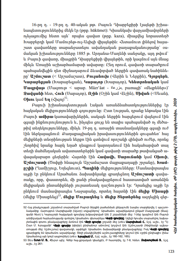
16th century - 19th century. 40s. Balun was one of the principalities (Turkish: hükümet) of the Diyarbakir eyalet. After the destruction of the semi-independent administrative units, it was incorporated as a province (Turkish: kaza) into the newly created vilayet of Kharberd or Mamuret-ul-Aziz. Following the traditional policy of separating the Armenian-populated provinces, the Ottoman authorities in 1885 The Sanjak of Ardana-Maden, including the Balu province, was annexed to the Diyarbakir vilayet, in which it remained until the end of World War I. At the same time, the internal provinces-nahyens formed in the Middle Ages were preserved within the territory of the province: Ashmushat (< Arshamashat), Bulanukh (Upper and Lower), Gökdere Karabekyan (Kharabegyan), Karachor (Kharachor), Central or Mazrvat (Mazrut < Arabic: Mazrat - le jja, literally "margins") with Javgan. Hun (Sarachor), Voshin (Oshin or Veshin), Sivan (<Sevan), Okhu or Yegh (Khizol). One of the essential features of the Balu principality was the existence of Armenian melikiyas. In essence, they were subordinate to the Balu amir-governors, but in internal matters they enjoyed considerable independence and, as the limited amount of information preserved shows, until the 19th century. The first decades of the Armenian Meliks represented considerable power. In parallel with the civil jurisdiction, certain armed forces were under the control of the Armenian Meliks, thanks to which they were able to counterattack the local Muslim lords or the nomadic tribes that had penetrated the territory of the province, if necessary. The Meliks of Havav, Sarujan or Okhu, Ashmushat (the region of the ancient Arshamashat capital of Tsopk), Kham-ishli (Ghamishlur, Yeghegnut), and Paghin were known. The Ashmushat Gava-rak, occupying the left bank of the Aratsan River, was particularly prominent, which was, in fact, a kind of federation of separate Melik families established in several settlements. Among them, Najaran was particularly prominent, where the influential vassals of Melik Misak (Melik Misakents), Melik Muradents, and Melik Terterents were known.
"The Khotoyants (Kurtoyants), Mahtesyans and Oghkasyans were prominent in Paghin. In the village of Trkhe or Trkhe in Ashmushat, the Khtoyans, Haji Davityans, Mrtesyans, Manukyans, Melik-Epsoyans, Khachikyans, families of melik origin were known." There is also information about the influential ancestor of the Vardan dynasty of the village of Khamishli (Qamishluk) in the province of Javgan, located north of Aratsan, Melik Khto. Some facts allow us to speak about military cooperation between individual meliks. In this regard, the joint struggle of the Havav melik Marto and the Sarujan (Okhu) melik Lama against the neighboring bey of Japaghjri is particularly noteworthy in the early 19th century. The fact of the armed cooperation of the Havav melik Marto and the neighboring Dersim Gzhigan (Kzhikan) dmlika tribe is also noteworthy. However, the constant battles against the Muslim (Kurdish and dmlika or Zaza) avad owners, as well as the penetration and increasing pressure of new foreign tribes, undermined the once-powerful power of the Balu meliks. The Armenian meliks suffered particularly heavy and irreversible losses during the period of tribal (tribal) anarchy that prevailed in the first decades of the 19th century. During the inter-tribal wars, the Armenian-populated villages of Mazrvat, Javgan and Karachor (Kharachor) suffered especially badly. By the way, during this period, cases of the extermination or forced conversion of individual meliks, even melik families, were recorded. Thus, the aforementioned melik Khto of Khamishli (Ghamishlur) was killed along with his 3 sons, and the melik settlement, which, according to tradition, had 140 Armenian households, turned into a sparsely populated village. It is noteworthy that the other surviving members of the Vardan dynasty forcibly converted to Islam and assimilated, receiving the nickname Verdan-zade or Papaz-oghly ("our fathers"). Near the village of Khoshmat in Balu, the melik Lama of Okhu (Sarujan) was also assassinated by conspiracy. Gradually losing their traditional political authority, the local Armenian meliks turned into ordinary village heads, albeit from more influential clans.
Zrzut ekranu 2025-03-24 185006.png
 
Last edited:
This text mentions some Yezidi principality near Savur, do you know which principality this is? @Ispil
Could this country be the Emirate of Şirvan?
Xarzan or, Harzan

Yazidism in Turkey​


MARDIN SANJAK 3. Savur (Avine) province It occupied the northern part of the Mardin sanjak, including the valleys of the right-bank (southern) Savur and Sheikhan tributaries of the Western Tigris. Almost through the center of the province, from south to north, stretched the small mountain range of Sultanyaylağı, which divided the territory of the province into 2 parts: eastern - Bun Savur, and western - Avine. It bordered the Diyarbakir sanjak from the north and west, the Midyat provinces from the east and south, and Mardin provinces from the south. The center was the town of Savur on the banks of the river of the same name. In the early Middle Ages it was called Tsavur (Tsavur, in Byzantine sources - Thaúpaç, Assyrian: Sawro, Sor or Sur). It was a famous Byzantine fortress and episcopal seer. According to G. Inchijyan's data, at the beginning of the 19th century, the majority of the population of Savur province was Armenians, who were endowed with
"were with great autonomy". Unfortunately, this is where our information ends. Judging by the reports of the primary sources known to us from the beginning of the 20th century, the Armenian power gradually weakened and declined throughout the 19th century. Moreover, the majority of Armenians and Assyrians were Muslimized and assimilated". According to the author, the policy adopted by the Second Door in the 1830s-1840s played a sinister role in this, in particular, the destruction of the semi-independent Armenian-Yezidi power of Kharzan or Sgherd, which bordered Savur from the north. According to the data of the Diyarbakir Primate, in 1914 The Armenian population, slightly exceeding 1,000, was preserved only in the administrative center of the province and about 15 km northwest of the latter, in the town of Avine (Asyrian: Owena or Awina, now renamed Sürgücl), located on the right bank of the Sheykhan River. The Armenians were predominantly Catholic and were mainly engaged in gardening (according to Gh. Inchijyan, Savur was famous for its plum harvest). During the years of the Great Genocide, the Armenians and Assyrians of the province were exterminated. The population of the Assyrian town of Kelet (Asyrian: Qeleth, pp. Killit) made an unsuccessful attempt at resistance, after which it was also subjected to a mass massacre (more than 2,000 people). 1914. In Savur province 1 Armenian school operated with 195 students. 10 ARGHANA-MADEN SANJAK 4. Balu province (Balahovit) Balu province included the northern parts of Diyarbakir vilayet, extending from the Armenian Tavros to the Keghi River (historically, the Other Gaylget). The central region of the province occupied the fertile Balu plain, from which, on the left bank of the Aratsan-Murat, the Ashmushat or Vardenyats valley spread. It bordered on the north with the Erzru vilayet, on the east with Bitlis, and on the west with Mamuret-ul-Aziz or Khar-berd vilayet. In the south were the Lrche and Maden (Arghana) provinces of Diyarbakir vilayet. The center was the city of Ha-Manun, located on the right bank of the Aratsan
View attachment 1270991

Savur Province​


I wonder if the Sheikhan Principality mentioned by @AirikrStrife exists in the year 1337?


View attachment 1271010


Palu/Balu
16th century - 19th century. 40s. Balun was one of the principalities (Turkish: hükümet) of the Diyarbakir eyalet. After the destruction of the semi-independent administrative units, it was incorporated as a province (Turkish: kaza) into the newly created vilayet of Kharberd or Mamuret-ul-Aziz. Following the traditional policy of separating the Armenian-populated provinces, the Ottoman authorities in 1885 The Sanjak of Ardana-Maden, including the Balu province, was annexed to the Diyarbakir vilayet, in which it remained until the end of World War I. At the same time, the internal provinces-nahyens formed in the Middle Ages were preserved within the territory of the province: Ashmushat (< Arshamashat), Bulanukh (Upper and Lower), Gökdere Karabekyan (Kharabegyan), Karachor (Kharachor), Central or Mazrvat (Mazrut < Arabic: Mazrat - le jja, literally "margins") with Javgan. Hun (Sarachor), Voshin (Oshin or Veshin), Sivan (<Sevan), Okhu or Yegh (Khizol). One of the essential features of the Balu principality was the existence of Armenian melikiyas. In essence, they were subordinate to the Balu amir-governors, but in internal matters they enjoyed considerable independence and, as the limited amount of information preserved shows, until the 19th century. The first decades of the Armenian Meliks represented considerable power. In parallel with the civil jurisdiction, certain armed forces were under the control of the Armenian Meliks, thanks to which they were able to counterattack the local Muslim lords or the nomadic tribes that had penetrated the territory of the province, if necessary. The Meliks of Havav, Sarujan or Okhu, Ashmushat (the region of the ancient Arshamashat capital of Tsopk), Kham-ishli (Ghamishlur, Yeghegnut), and Paghin were known. The Ashmushat Gava-rak, occupying the left bank of the Aratsan River, was particularly prominent, which was, in fact, a kind of federation of separate Melik families established in several settlements. Among them, Najaran was particularly prominent, where the influential vassals of Melik Misak (Melik Misakents), Melik Muradents, and Melik Terterents were known.
"The Khotoyants (Kurtoyants), Mahtesyans and Oghkasyans were prominent in Paghin. In the village of Trkhe or Trkhe in Ashmushat, the Khtoyans, Haji Davityans, Mrtesyans, Manukyans, Melik-Epsoyans, Khachikyans, families of melik origin were known." There is also information about the influential ancestor of the Vardan dynasty of the village of Khamishli (Qamishluk) in the province of Javgan, located north of Aratsan, Melik Khto. Some facts allow us to speak about military cooperation between individual meliks. In this regard, the joint struggle of the Havav melik Marto and the Sarujan (Okhu) melik Lama against the neighboring bey of Japaghjri is particularly noteworthy in the early 19th century. The fact of the armed cooperation of the Havav melik Marto and the neighboring Dersim Gzhigan (Kzhikan) dmlika tribe is also noteworthy. However, the constant battles against the Muslim (Kurdish and dmlika or Zaza) avad owners, as well as the penetration and increasing pressure of new foreign tribes, undermined the once-powerful power of the Balu meliks. The Armenian meliks suffered particularly heavy and irreversible losses during the period of tribal (tribal) anarchy that prevailed in the first decades of the 19th century. During the inter-tribal wars, the Armenian-populated villages of Mazrvat, Javgan and Karachor (Kharachor) suffered especially badly. By the way, during this period, cases of the extermination or forced conversion of individual meliks, even melik families, were recorded. Thus, the aforementioned melik Khto of Khamishli (Ghamishlur) was killed along with his 3 sons, and the melik settlement, which, according to tradition, had 140 Armenian households, turned into a sparsely populated village. It is noteworthy that the other surviving members of the Vardan dynasty forcibly converted to Islam and assimilated, receiving the nickname Verdan-zade or Papaz-oghly ("our fathers"). Near the village of Khoshmat in Balu, the melik Lama of Okhu (Sarujan) was also assassinated by conspiracy. Gradually losing their traditional political authority, the local Armenian meliks turned into ordinary village heads, albeit from more influential clans.
View attachment 1270995
Okay, so a few things. For Sheikhan, I already suggested Daseni for that exact region which would fit what they describe. Palu didn't exist in the 14th century. We know this because it was founded by its conqueror, Husein Beg, a lord from the Principality of Eğil, in the 16th century. As for Şirvan, I suggested it as Hizan. Unless you mean a state in Siirt, in which case that already exists on the map.
 
Palu didn't exist in the 14th century. We know this because it was founded by its conqueror, Husein Beg, a lord from the Principality of Eğil, in the 16th century.
This is not about the Emirate of Palu but about the Armenian vassals of this emirate. I was wondering if you had any information about them?
As for Şirvan, I suggested it as Hizan. Unless you mean a state in Siirt, in which case that already exists on the map.
I was not referring to the Emirate of Siirt or Hizan.
I am talking about the city of Kurtalan which Armenians call Kharzan/Harzan, was there a Yazidi emirate there or was this city owned by other emirates?
The text says something about an Armenian-Yezidi country, I just wonder if it is a country where Armenians rule and practice Yezidism.
Unless it is simply a state of Kurds practicing Yezidiism who have some vassal relations with the city of Savur.
Savur is probably ruled by Armenians who are probably dependent on this principality.
1742848599570-png.1271059


Zrzut ekranu 2025-03-24 211404.png
 

Attachments

  • 1742848599570.png
    1742848599570.png
    18,1 KB · Views: 0
This is not about the Emirate of Palu but about the Armenian vassals of this emirate. I was wondering if you had any information about them?

I was not referring to the Emirate of Siirt or Hizan.
I am talking about the city of Kurtalan which Armenians call Kharzan/Harzan, was there a Yazidi emirate there or was this city owned by other emirates?
The text says something about an Armenian-Yezidi country, I just wonder if it is a country where Armenians rule and practice Yezidism.
Unless it is simply a state of Kurds practicing Yezidiism who have some vassal relations with the city of Savur.
Savur is probably ruled by Armenians who are probably dependent on this principality.
1742848599570-png.1271059


View attachment 1271051
Given the general competition between the Artuqid city-state of Mardin and the Ayyubid city-state of Hasankeyf, I'm skeptical that there's a significant polity between them. Particularly one that as far as I can tell pretty much never comes up in the sources.

To be blunt, I significantly doubt the actual amount of sway any of these Armenian polities had in 1337 aside from being remote villages inhabited by Armenians. These were places that maintained independence not by virtue of force-of-arms, but by virtue of inhospitable terrain and general irrelevance in the broader geography (by which to say, they weren't on major roads). I do not think representing them as states would be a good representation.
 
  • 2
  • 1
Reactions:
I do not think representing them as states would be a good representation.
Serious question: how should they be represented then? Even if it's "not at all" one still needs to have the places on the map be something.
 
Given the general competition between the Artuqid city-state of Mardin and the Ayyubid city-state of Hasankeyf, I'm skeptical that there's a significant polity between them. Particularly one that as far as I can tell pretty much never comes up in the sources.

To be blunt, I significantly doubt the actual amount of sway any of these Armenian polities had in 1337 aside from being remote villages inhabited by Armenians. These were places that maintained independence not by virtue of force-of-arms, but by virtue of inhospitable terrain and general irrelevance in the broader geography (by which to say, they weren't on major roads). I do not think representing them as states would be a good representation.
I think that adding the Countries of Akdamar/Rshtunik, Maku/Artaz and Sasun makes sense, the rulers of these cities conducted foreign policy by seeking an alliance with Europeans.
Zrzut ekranu 2025-03-25 163021.png

Zrzut ekranu 2025-03-16 204619.png

Zrzut ekranu 2025-03-25 164148.png

 
  • 1
Reactions:
I think that adding the Countries of Akdamar/Rshtunik, Maku/Artaz and Sasun makes sense, the rulers of these cities conducted foreign policy by seeking an alliance with Europeans.
View attachment 1271428
View attachment 1271432
View attachment 1271436
Biggest issue with Akhtamar is that it's an island on a lake. I fear it's too small as a standalone location. Sasun and Maku are fine.
 
Biggest issue with Akhtamar is that it's an island on a lake. I fear it's too small as a standalone location. Sasun and Maku are fine.
The same can be said about Hormuz Island, instead of adding an island they moved the location to Qeshm Island. Here the location can be moved to the mainland.
This location can be called Manakert because this castle was the capital of the Rshtunik region

Zrzut ekranu 2025-03-25 182733.png

Zrzut ekranu 2025-03-25 183242.png
 
Last edited:
For the ones that did little more than exist, I'm not sure there's much other representation aside from having an Armenian population presence in that location.
You wouldn't support any other sort of debuff to represent the effective independence of such locations?