• We have updated our Community Code of Conduct. Please read through the new rules for the forum that are an integral part of Paradox Interactive’s User Agreement.

Tinto Maps #2 - 17th of May 2024 - Iberia

Hello everybody, and welcome to the second post of Tinto Maps! We’re really pleased about the great reception that the first one had last week, and also about the great feedback that we received. Just so you know, we have more than 70 action points from it that we will be implementing soon in the game.

Today we will be unveiling the map of Iberia in this super-secret project! So let’s start showing maps without further ado:

Countries:
Countries.jpg

The situation in 1337 shows a strong Crown of Castile under the rule of Alfonso XI, who has overcome the problems of his troublesome minority. To the east, we have the Crown of Aragon (it’s named that way, even if it currently doesn’t appear like that on the map), which is fighting for hegemony over the Mediterranean. An offspring of it is the Kingdom of Mallorca, ruled by a cadet branch of Aragon since half a century ago, that also has a couple of northern possessions centered on Perpignan and Montpellier. To the north, the Kingdom of Navarra is ruled by a French dynasty, its titular queen Jeanne, a member of the Capetian dynasty, being married to Philippe, Lord of Évreux. To the west, Portugal has a tense relationship with Castile, with a war being fought during 1336. To the south, the Nasrid dynasty holds power in Granada, backed by the Marinids of Morocco, who have a foothold in the peninsula centered around Algeciras and Ronda. And yes, Andorra is a starting country.

Locations:
Locations.jpg

Note: We are aware that there are some locations that could be added here and there, as this was one of the first maps that we created, and we weren’t completely sure about the location density we would like to have in the game. Some examples of possible locations that we’d like to add during a review would be Alicante, Tarifa, Alcobaça, Tordesillas, Monzón, or Montblanc. Also, you might notice that Zaragoza is named 'Saragossa'; this is not final, it's because we're using it as our testing location for the dynamic location naming system, as it has different names in Spanish (Zaragoza), Catalan (Saragossa), English (Saragossa), French (Saragosse), or Arabic (Saraqusṭa).

Provinces:
Provinces.jpg

Although it looks a bit like the modern provincial borders, take into account that those are based on the provincial reform of Francisco Javier de Burgos, which were also inspired by the cities/provinces that were accountable for the ‘Servicio de Millones’ during the reign of Philip II. Also, please, don't focus on the province names, the language inconsistency is because we were also using them as a testing ground.

Terrain:
Climate.jpg

Topograhpy.jpg

Vegetation.jpg

Iberia has one of the most complex terrain feature distributions in the entire world. We've also discussed this week that we're not very happy about the Vegetation distribution, which we'll be reworking, so feedback on this topic is especially very well received.

Cultures:
Cultures.jpg

Quite standard cultural distribution here, based on the different languages of Iberia (Asturleonese was still a language back in that time, although close to being opaqued by Castilian, after one century of joint ruling). The Andalusi represent not only the Muslim inhabitants of Granada and the Strait of Gibraltar but also the Mudéjar communities spread throughout much of the territory.

Religions:
Religion.jpg

The Sunni populations present here match the Andalusi pops of the previous map. Although it’s not shown in the map mode, there’s another important religious community in Iberia, the Sephardic Jews, who inhabit several cities and towns.

Raw Goods:
Raw Goods.jpg

This is also a map mode that we'll be revisiting next week, and feedback is also very welcomed. A curiosity: for the first time in a Paradox GSG, there is the Mercury resource in Almadén.

Markets:
Markets.jpg

This is the current distribution of markets, please take into account that it is based on the current gameplay status of the system and that it won’t necessarily be its final status. We tested in previous iterations having market centers in Lisbon and Burgos, but they weren’t working as we wanted; thus why we only have market centers in Sevilla and Barcelona. As the markets are dynamic, it might be possible to create new market centers, so a Portugal player might want to create a new market in Lisbon after some years (although having access to the market of Sevilla is juicy if you get enough merchant capacity on it).

Pops:
Pops.jpg


And that’s all for today! Next week we will be traveling to France! See you then!
 
  • 281Love
  • 156Like
  • 11
  • 8
  • 1
Reactions:
It's taken me a while but, as promised @Pavía, some feedback on the aragonese/navarrese bits of the map. First and foremost, I'm sorely missing both Borja and Monzón. Monzón, even if it wasn't officially a "city", it was relevant and the place where the "cortes" of the three kingdoms used to meet. Borja, because in the XIVth and XVth century it was one of the biggest cities in the whole kingdom. Around 1400, the biggest cities would be (ordered by population) Zaragoza, Alcañiz, Calatayud, Huesca, Daroca , Huesca, Borja, Teruel, Fraga, Ejea and Barbastro.

I know placing Borja and Tarazona in the map wouldn't be easy, as they are really close to each other, but you've done the trick in the Low Countries.

Very please to see though that you went for Benabarre and not Graus, which only became more important in the XIXth century... but I'd consider naming that location as "Ribagorza". And potentially the same with Aínsa, making it "Sobrarbe". I think it was @Zaragoza that gave some really good feedback on the trade goods and shape of all those provinces, I fully agree with him.

About the cultures map: a majority of basques in Southern Navarra? The language there was actually navarro-aragonese! I'd say that at least Tudela and Olite should be a majority of... that: navarro-aragonese, if you're going with the name of languages for the different cultures.

But now, my main thing here:

View attachment 1135790

This is so wrong in so many ways. I was trying to find here at home a book I'm pretty sure my mother still owns about late medieval Aragón to help with the figures (counted by fireplaces, as it was the norm back then), and I'll keep looking, but for now: Zaragoza should be at least four times bigger than Calatayud and Alcañiz, and double the size of Tudela. And I don't mean increasing the population of Zaragoza (maybe just a little bit, but not really much): the rest of locations should have way LESS population.

The only source I've found online mentions 1495, which I know, very different, but Zaragoza had nearly 4,000 fireplaces while Calatayud barely had 1,000 and Alcañiz around 750. I know you need to take into account not just the main locations but other relevant places not shown in the map... but the difference was staggering. The population in Aragon has always been concentrated around Zaragoza and the map does not reflect that.
When comparing with the Fogaje of 1495, we must take into account that they are after the Black Death (so population in 1337 may actually be similar or even higher). Depending on how the plague is modeled in the game it may be wise to somewhat overstate inital figures (so as they don't fell too much that they don't reach 1495 values later on).

My main concern is that things need to be internally coherent between comparable locations. For example, the Castille-Aragon border is a problem because available data (an even modern scholarship) may not be comparable (different census, with different data, criteria, focus...). So Castille is to be more densely inhabited, but we shouldn't just use different data at face value. That's why I got so suprised to see very similar locations just opposite of borders to be so different in a period in which frontiers were a lot more permeable than now. Agreda-Tarazona, Tudela-Tarazona, Calatayud-Medinaceli or Sangüesa-Jaca having a 2x differences seems too harsh, specially when qualitative data (bishopship seats, past regional capital status, political dependence and urban status in sources etc) points to even the reverse situation.

Similarly, Tudela, Zaragoza and Lérida (with Zaragoza being the main one among the three) confomed the backbone of the urban network of the Ebro Valley since roman times (if we do a Tudela-Cascantum correction) . We can see the conventus Caesaraugustanus with Zaragoza as capital but Cascantum and Ilerda as municipium (second tier divisions) and match it with the Upper March (capital in Zaragoza, dependent coras in Huesca, Tudela, Calatayud, Lerida) and the later Taifa of Saraqusta (which usually had vassal taifas in the same districts as before). I'm not sure about the visigoth period (there were visigoth counts for Zaragoza / Ebro valley but I don't think the detailed area they commanded is clearly known). After the christian conquest the Aragonese-Sobrarbe-Ribargoza-Pamplona kingdoms with its divisions and reunification did hint a bit approaches like that just before Project Caesar start. So I'd argue the three historical urban areas there should have some coherence.

In defense of the map shown by Pavia, the locations of Pina de Ebro and part of Zuera were part of Zaragoza "metropolitan area" and Lerida and Tudela are not split. For example, the irrigation system from the Gallego river took the water north of the city of Zuera but the channels went until Mamblas, in Zaragoza. Several other villages of that system were considered part of the jurisdction of Zaragoza. The map does seem to take the Ebro as frontier (so it is likely forgetting even the Rabal on the other side of the bridge of Zaragoza). Tudela is, on the contrary, given the frontiers of their whole Merindad, which include a system of former muslim almunias that from the XII-XIII centuries were being reconverted to the current sistem of settlements around Tudela. So, in order to do the detailed check between the Ebro towns, I think there are some corrections to do to compensate for that. I've internally considering that Tudela should be ~= Fraga and Zaragoza+Pina+ 1/3 or 1/2 of Zuera should be slightly or a bit higher than those two if we want to have a realistic scenario.

Regarding local population distribution in Aragon, I think the War of the Two Peters effect must also be taken into account. Calatayud, Tarazona and Teruel are likely to have suffered a lot in the second third of the XIV century, whilst Alcañiz was far from the frontlines (and actually had its golden time in the XV century). So I'd argue Alcañiz is overstated in 1495 census whilst Western Aragon may be sligthly underrepresented if extrapolated from the fogajes.

Regarding Tudelas minority, a nice challenge to Pavía and its team may be to check whether we could have a gascon/bearnese minority (occitan speaking christian of southern french culture). Tudela did have a relevant gascon minority in the XII century but Lacarra thought it was very soon asimilated and Cierbide says there is no record of them in the XIII-XIV century. However, they are clearly recorded in northwestern Navarra and in current Guipúzcoa up to much later (the XV century?). I think Orella Unzué had some works regarding them. Besides Tudela, the cities of Jaca, Pamplona, Sangüesa and Puentelarreina also had relevant bearnese minorities whose integration in 1337 may be worth revisiting (Cierbide and Alvar had several onomastic studies of interest). Having the last of that minority at the start date would be a nice touch, but it may be setting a very high bar for historical accuracy.
 
When comparing with the Fogaje of 1495, we must take into account that they are after the Black Death (so population in 1337 may actually be similar or even higher). Depending on how the plague is modeled in the game it may be wise to somewhat overstate inital figures (so as they don't fell too much that they don't reach 1495 values later on).

I only mentioned that data to show that the difference in population between Zaragoza and the rest of the locations should be way, way bigger.
 
  • 1Like
Reactions:
On the Portugal section;

I really, really, really like this proposal. It's aesthetically pleasing, logical, a nice distribution and addresses a lot of the points I would have made; the most important one being of keeping Lisbon isolated in its peninsula. The only bit I'd add in is the inclusion of 'Feira' as a province between Esgueira and Porto, but if the developers went with this one as-is, I'd be VERY happy with the game.

Just some extra information I'd like to supply in case it hasn't been mentioned yet; on the region grouping, this is the distribution of the Portuguese medieval Comarcas, which were in force at the time of the game's beginning:
View attachment 1135765

Also, on a more informal note, there is this amazing map of the Iberian Peninsula's heraldry in 1444 by the artist known as ratkabratka. I'm not sure how it is referenced, but it is so detailed and inticrate that it's hard to believe it wasn't based off on some kind of data. I know it's unlikely, but I hoped the developers would take it into consideration as a reference:

dfekjwf-cdce8a2a-2f80-4ef1-960a-8354045a14ef.jpg
Thank you! It is indeed very useful, I can better see the logic for the Portuguese location borders Tinto used now! So, based on this map and a further look at other sources on regions I might have overlooked, there are a few more suggestions:

1716158151647.png


0: Najera
Najera was already suggested but not enumerated in the original post. One of the most important cities in the province, only slightly less so than Logorono by the game start. Had the title of a city since the 15th century, and was even the capital of a kingdom in the early middle ages

1.Ribadeo
A major trade port and county offering a split for Mondonedo. Notably it was the only port in Spain to trade with the Baltics and import their liquor. Primary industry seems to be Fishing, so Fish as the raw tradegood makes sense

2. Ribadavia
Important town and county, which had a large Jewish community. Off Very well known for its Wine exports. Also includes the County of Celanova, and offers a split for Ourense

3. Potes
The centre of the Liebana valley, this was a separate administrative division from the rest of Cantabria, even being independent or attached instead to Burgos at times. The area is known for Liebeana cheeses, so Livestock is the best tradegood.

4.Torrelavega
The second largest city of Cantabria today, this was a very important agricultural area throughout the period, so Wheat would be a good tradegood. However, Zinc mines were discovered here in the middle of the 19th century, so despite the lateness Zinc could also work

5. Saldana
Offers a split of the rather large Carrion de los Condes, and a county in its own right. Well known for the Saldana bean, so Legumes works well as a tradegood. Otherwise grows rye, so Sturdy Grains works too
1716158353465.png

6. Fuensalida
This one isn't the most necessary perhaps, due to the size, but it was a separate county and had town rights as well. Had a significant Muslim and Jewish population. Mostly known for producing Olives, but produces Wine as well.

1716158419186.png


7. Reus
Used to further split up the rather awkward borders of Montblanc, representing the Catalan county of Prades subject to it. Reus was its most important town. It has had town rights since the 12th century, and in the 17th century had 1200 houses (implying a population of well over 5000). Very well known for liquor and wine production, so Wine is a good tradegood choice, but the famous Reus hazelnut (as well as the liquors being fruity) means that Fruit would also fit great and would probably be the more unique choice for the area

The location of Terrassa was also redrawn to better fit the borders of the county of Valess.

8. Ceret
As previously mentioned under consideration, Ceret represents the counry of Vallespir. Would also include Banyuls if it isn't added. Famous for its Cherries, so it would produce Fruit

Portugal

The borders of Portugal were much improved using the map, also leading to several new additions:

1716158474854.png


1. Mertola
Split off from Serpa and solely within Ourique (while Serpa is only within Beja). As mentioned in the original post, would produce Copper due to the mines there

2. Viana de Alentejo
A separate county from Beja, this is another option to split the location.

Portel isn't actually within Evora, and is within the current borders of Moura - it was redrawn to account for that.

3. Montemor-o-Novo
The new split for Evora as Portel no longer serves this purpose. A separate Marquisate, the area is one of the biggest meat producers in Portugal, so Livestock would be a good tradegood.

1716158522467.png

Instead of primarly being used to split Castelo Branco, Covilha is instead the split for Guarda (where it's actually located)

4. Penamacor
The new split for Castelo Branco, it was another major castle meant to protect against Castille. The area is known for its wines of the same name, so Wine is the natural tradegood

Abrantes, Mirandola, Estrmoz and Braga also saw a significant change in their location shape.

Again, thanks for the excellent resource!
 
  • 9Like
  • 3
  • 1
Reactions:
After my initial post I've made some rearrangements after feedback and reading posts. This is a complement post

My explanations for some choices:

1, 2 - Lagos and Aljezur/Sagres. It could be just one province, or made the split in the vertical. The split meants to show the west coast of algarve. Lagos is south coast, and Sagres was a important place during this fase, and so was Lagos, so both could be in

3 - Silves was a important city during muslim rule. the Arade river was navigable until Silves, so it was a protected city from piracy and a gate from the hilly interior to the trade.

6 - Castro Marim/Alcoutim meants to represent the fortified border of Guadiana river. Guadiana was also a navigable river until Mértola and the crossings were heavily fortified.

9- Odemira borders goes further inside. The border between Alentejo and Algarve is very very hilly. Very few roads connects, poorly populated. and Odemira even today is the largest municipality of Portugal

12 - Beja was very well protected from spanish agression. Between Mértola and Monsaraz Portugal controls both sides of Guadiana river. This was only possible because of Moura, Serpa and Mértola.

16 - Évora is similar. The major crossing points were fortified. Monsaraz and Mourão were responsable for the zone

17 - Estremoz is a connection between east and west, north and south. Its trully a crossroads city. It was headquarters of the military responsable for defending the Alentejo during Portuguese independence. Many major battles took place near: Santa Vitória, Atoleiros, Montes Claros. It was a supportive fortification for Elvas, Campo Maior, Juromenha

22-23- The split in Portalegre its because there were two gateways to enter Portugal in this zone, north and south. Portalegre were more responsable for the south entry, with Alegrete castle. North passage it was Marvão and Castelo de Vide. Another fun thing is that this zone was populated in the XIII century with french people, that named some cities in reference to their homeland: Niza-Nice, Tolosa-Toulosse

24-Crato/Alter do Chão with less area, south of Tejo river, represent the agrarian land

25-26- Avis with less area. Still an important place because of Ordem de Avis Coruche to represent the fertile lands of Tejo (Lezirias do Tejo)

27-Setubal with less area.

29- Cascais/Sintra/Mafra. Very hilly terrain and farmland to feed the capital

30 - Torres Vedras blocking the acess to Lisboa

32, 33 - Abrantes was the main gate north/south of Tejo river. Tomar also a important place. Borders not ideal in my map. Probably Abrantes to connect with Castelo Branco and not Tomar

35 - Sabugal was a very important place in the defense of Beiras. Sabugal and Penamacor were the defenses north and south of Serra da Malcata

38 - Covilhã/Belmonte. I believe that early on Belmonte were more important than Covilhã. Belmonte was the birthplace of Pedro álvares Cabral. And it should be the mountain province

52-53. Montalegre was also a possible gateway from Galicia, not only Chaves. And Chaves should be bordering Bragança.

51-Mirandela was a important city in the region

54 - Bigger Vila Real so it can border north in Chaves
 

Attachments

  • Mapa portugal.png
    Mapa portugal.png
    804,2 KB · Views: 0
  • 5Like
  • 1Love
Reactions:
It's amazing work! I really like how it goes. :p :p

I'm going to make a couple of suggestions about the province of Murcia, where I live (obvious, okay)

1- First of all, I think the location of Caravaca de la Cruz is missing. Caravaca had its own jurisdiction and was the third largest city in population in Murcia during the 16th century, when it experienced a boom when the reconquest was completed, as it served as a connection between the newly conquered Granada and the Christian kingdoms.
It is one of the five holy cities of Christianity and a place of pilgrimage for a miracle that supposedly occurred here during the reconquest, which is why it is called "de la Cruz". In addition, its super defensive situation, with a mountain fortress, prevented the Muslims from attacking from Granada and revolting.
It also has an important modern history, as it was taken by Napoleon during the War of Independence and remains a relatively important city today.
1716171803345.png

2- I also think that the fact that Murcia produces wine should be reviewed, since this was one of the main silk manufacturing cities in Spain during that time. Although it is true that on the start date of the game it was not yet produced. Maybe it could be fruits, due to its orchard specialized in citrus and mulberry trees, although these were based in the silk industry.
Thanks for reading, and looking forward to playing!
 
Last edited:
  • 1Like
Reactions:
3. Tarifa
Another location you recommended yourself, Tarifa was already captured by Castille by 1337 and was their main military base in the Strait. While it lost some of its importance with the fall of Granada, it still had about 4000 inhabitants by late 16th century and its own marquisate. It's most prominent resources were Horse husbandry and tuna Fishing.

I would also redraw Gibraltar to look better when owned as a single-location outpost, for obvious reasons.

Would including Medina-Sidonia in a location with Tarifa make sense? Together with Tarifa it would be a front-line defensive location. The raw good could possibly be tuna since they practiced an ancient form of fishing there as well as nearby.

Edit: The trade good in EU4 is naval supplies, but I'm not sure if that corresponds to a raw good.


Also, the remaining portion of Cádiz would correspond to the Cádiz wine region, which includes the wine region for Sherry, one of the finest wines during this time period and considered a necessity for the explorers sailing from Cádiz to the Americas (Magellan spent more on sherry than weapons for his voyage). And the English particularly enjoyed Sherry following the increased demand and production after the Fall of Constantinople and the completion of the Reconquista.


TL;DR Cádiz should have wine there.

Well, maybe since Sherry is a white wine, it may not go well with Tinto. :)
 
Last edited:
  • 1
Reactions:
Hello everybody, and welcome to the second post of Tinto Maps! We’re really pleased about the great reception that the first one had last week, and also about the great feedback that we received. Just so you know, we have more than 70 action points from it that we will be implementing soon in the game.

Today we will be unveiling the map of Iberia in this super-secret project! So let’s start showing maps without further ado:

Countries:
View attachment 1134319
The situation in 1337 shows a strong Crown of Castile under the rule of Alfonso XI, who has overcome the problems of his troublesome minority. To the east, we have the Crown of Aragon (it’s named that way, even if it currently doesn’t appear like that on the map), which is fighting for hegemony over the Mediterranean. An offspring of it is the Kingdom of Mallorca, ruled by a cadet branch of Aragon since half a century ago, that also has a couple of northern possessions centered on Perpignan and Montpellier. To the north, the Kingdom of Navarra is ruled by a French dynasty, its titular queen Jeanne, a member of the Capetian dynasty, being married to Philippe, Lord of Évreux. To the west, Portugal has a tense relationship with Castile, with a war being fought during 1336. To the south, the Nasrid dynasty holds power in Granada, backed by the Marinids of Morocco, who have a foothold in the peninsula centered around Algeciras and Ronda. And yes, Andorra is a starting country.

Locations:
View attachment 1134322
Note: We are aware that there are some locations that could be added here and there, as this was one of the first maps that we created, and we weren’t completely sure about the location density we would like to have in the game. Some examples of possible locations that we’d like to add during a review would be Alicante, Tarifa, Alcobaça, Tordesillas, Monzón, or Montblanc. Also, you might notice that Zaragoza is named 'Saragossa'; this is not final, it's because we're using it as our testing location for the dynamic location naming system, as it has different names in Spanish (Zaragoza), Catalan (Saragossa), English (Saragossa), French (Saragosse), or Arabic (Saraqusṭa).

Provinces:
View attachment 1134324
Although it looks a bit like the modern provincial borders, take into account that those are based on the provincial reform of Francisco Javier de Burgos, which were also inspired by the cities/provinces that were accountable for the ‘Servicio de Millones’ during the reign of Philip II. Also, please, don't focus on the province names, the language inconsistency is because we were also using them as a testing ground.

Terrain:
View attachment 1134325
View attachment 1134326
View attachment 1134378
Iberia has one of the most complex terrain feature distributions in the entire world. We've also discussed this week that we're not very happy about the Vegetation distribution, which we'll be reworking, so feedback on this topic is especially very well received.

Cultures:
View attachment 1134456
Quite standard cultural distribution here, based on the different languages of Iberia (Asturleonese was still a language back in that time, although close to being opaqued by Castilian, after one century of joint ruling). The Andalusi represent not only the Muslim inhabitants of Granada and the Strait of Gibraltar but also the Mudéjar communities spread throughout much of the territory.

Religions:
View attachment 1134335
The Sunni populations present here match the Andalusi pops of the previous map. Although it’s not shown in the map mode, there’s another important religious community in Iberia, the Sephardic Jews, who inhabit several cities and towns.

Raw Goods:
View attachment 1134336
This is also a map mode that we'll be revisiting next week, and feedback is also very welcomed. A curiosity: for the first time in a Paradox GSG, there is the Mercury resource in Almadén.

Markets:
View attachment 1134381
This is the current distribution of markets, please take into account that it is based on the current gameplay status of the system and that it won’t necessarily be its final status. We tested in previous iterations having market centers in Lisbon and Burgos, but they weren’t working as we wanted; thus why we only have market centers in Sevilla and Barcelona. As the markets are dynamic, it might be possible to create new market centers, so a Portugal player might want to create a new market in Lisbon after some years (although having access to the market of Sevilla is juicy if you get enough merchant capacity on it).

Pops:
View attachment 1134340

And that’s all for today! Next week we will be traveling to France! See you then!
 
Oficial name of "Palma de Mallorca" is just Palma without the name of the island. "Ibiza" oficial name is Eivissa, and the small island name Formentera. I'm from Manacor, Rafa Nadal land, so i'm so happy to see here! And Xàtiva is oficial name too (close to Valencia)
 
  • 3
  • 1Like
Reactions:
I have two Questions, not sure if they where answered anywhere. Do we know how big the Map is? E.g. I:R 8192x4096, Vic 3 is 8192x3616 etc.
Also curious, on what are the Locations based? Meaning their physical representation/shape? For what would i look (in real map data) if i want to dive deeper on that topic?
 
Notes from outside Aragon regarding location:
  • I'd split Tolosa between Tolosa and San Sebastian, to better represent the maritime part
  • La Rioja feels a bit weird. Briviesca is in Burgos province but in the map covers most upper La Rioja. That frontier evolved a bit depending on the period but I think it will be better to have Santo Domingo de la Calzada or Najera to cover the upper third of La Rioja.
  • I really like you having Agreda to model the Aragones/Castillian/Navarres border. But Agreda is in the Queiles river, which flows into Tarazona. It will be better to extend Calahorra to the south (including the Cameros area) and the currently having eastern half of Calahorra as a separate location called Alfaro. Agreda can survive but reduced in size.
  • Talarn should be renamed Pallars
Economic:
  • Could you swap iron and stone between Briviesca and Villarcayo? Cantabrian stoneworkers were pretty much a thing. I'll need to review a book I bought in Burgos but there were some historic ironworks in norther Burgos
  • Ubeda and Baeza are quite an olive area. It can have lumber (it was used as lumber source for the navy too), but wheat was unexpected there.

San Sebastián had been founded to be the main port of Pamplona/Navarra originally too before it was annexed to Castille around 1200 I understand, and even after Navarra became landlocked it seems that Navarrese trade passed that way through Castille still. It definitely seems like it should be it's own province not only for its own historical significance, but for gameplay significance too as it could be a potential target for a Navarra player utilising whatever mission/events system the game eventually has. And maybe even cross border trade flow depending on how that system works out in the end, as landlocked medieval states should still have sea born trade access in some manner given how porous borders were at the time.
 
  • 1Like
Reactions:
Shouldn't Aragon be a composite monarchy? And what about the military orders? There is potential to explore here. An interesting system when playing the Spanish crowns or any attempt to unify those, when the monarch has to balance his requests to each crown/military orders and its privilegies. The Cortes system and the Fors/Forals granted to each entity could play a part in requesting taxes and troops. A control system was mentioned in Tinto Talk, adding a layer here would be interesting. The history of Spain is filled with revolts that resulted from this like the Portuguese Restauration and the Reapers War.
 

Attachments

  • SP 1591.gif
    SP 1591.gif
    340,1 KB · Views: 0
  • 3Like
  • 1
Reactions:
Great job!! I am absolutely hyped about Project Caesar. More granularity, population, climate... everything sounds amazing.

If you allow me, I have some comments that I would like to share with the community. I am neither a historian nor a geographer, but as an amateur in both disciplines, I would like to contribute what I have been able to collect during the weekend. I hope it is useful to you!

1. POPULATION

The first thing I think that can be improved is population numbers. I have added by provinces and regions and I have obtained the following table:

Population.png


Please note that this is just current Spain + Perpignan. In general terms, I think that the total amount of population is over the estimations historians usually do. The most commolny accepted population data for year 1500 is 4.5-5 M for Castille, 1 M for Aragon and maybe 200k for Navarre. Although there are very few population data sources from the middle ages, it is also usually assumed that the population level at the Medieval Optimum was recovered approximately at year 1500, so this approximations are not so far from a feasible reality.

Checking each territoty separately, I find that Catalonia, Trasmiera and Old Castille are especially overpopulated. New Castille maybe is a bit overpopulated too. The rest are quite well balanced in relation to the data I found.

My main source is "Poblaciones de las ciudades en la Baja Edad Media" (Miguel Ángel Ladero Quesada, Real Academia de Historia) but other minor sources have been found on the Internet.

Let me give you some detail and a proposal:

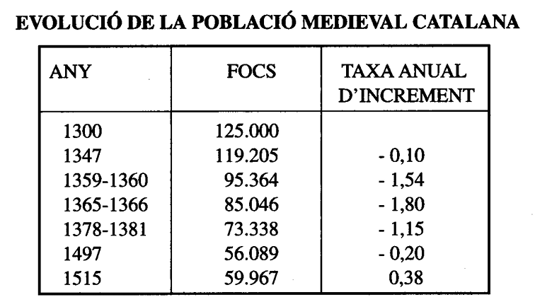
  • Catalonia: my calculous from the map provided last Friday gives me ca. 850k. According to "La Demografia Baixmedieval Catalana" (Gaspar Feliu, Universitat de Barcelona) an estimation can be done like the one shown below. The author considers 1 foc (family) as 4 people, giving an approximation of 500.000 people. The fotatges sources cited at "Poblaciones de las ciudades en la Baja Edad Media" give similar data. In the case of Catalonia and especially Barcelona, the impact of the Black Death and the rise of Valencia caused that by 1500, the population was still half of the Medieval Optimum.
1716194508215.png


  • Trasmiera is much difficult to estimate. Consider an indirect calculation: Basque Country is given an estimation of 180k in 1500. Other estimations give 50.000 people at Álava in 1530, both consistent. Assuming the same population density, Trasmiera would have ca. 100k people in 1500. Considering also the same assumption made before concerning the recovery of the population at 1500, Trasmiera would have had more or less 100k people in 1337. It is a very rough estimation with fewer sources. The Censo de Pecheros (1528) indicates approximately 10-11k pecheros (50-60k peasants) in 1528 in Trasmiera. This would show that Trasmiera is less population dense as Vizcaya, so in 1337 in Trasmiera we would have maybe 60 or 70k people.
  • Old Castille: This region is also difficult to estimate, due to its extension and complexity. In general terms, considering 4.5-5 million people in the Crown of Castille in the Medieval Optimum, the north part of Castille could be estimated in 1.3 million ("Poblaciones de las ciudades en la Baja Edad Media") In a more granular level, it can be easy to find some inconsistencies.

2. CLIMATE

This is much shorter to explain. I just got a bit shocked with the map. I do not know the effects that each climate will have in the game, but please consider changing some parts of thee "Cold Arid" regions to "Mediterranean". I have followed the Koppen classification:

1716196404487.png


and the rainfall map:

1716196451915.png


Pure arid regions can be southeast as you set in the map, Ebro valley and central Toledo, but not the Valencia and Catalonia costline, Mallorca and most parts of Castille.

I hope that my small feedback is useful for your development. I have loved everything I have seen about Project Caesar and I hope to continue seeing more progress. Thank you so much!!
 
  • 5Like
  • 1
Reactions:
Just a bit about the Portuguese population.

Long-term growth is reflected in the founding of new settlements and monasteries in Minho in the eleventh and twelfth centuries and in the clearing of newly conquered lands for agriculture in the Lower Mondego and Estremadura in the thirteenth century. Population stood at about 700,000 by the end of the 1200s, and was divided unequally between the northern and southern halves of the kingdom (Mattoso and Sousa 1993:245). The Minho, the Douro valley, and Upper Beira had a greater number of inhabitants. Here settlement was disperse, while in Lower Beira and south of the Tagus, the less populated regions, settlement was more concentrated. Some important urban centers, such as Lisbon and Porto, were along the coast, but the greater part of the population lived further inland. Lisbon had about 10,000 inhabitants at the time of the Reconquista (1147). By the end of the 1300s, with 35,000 people, it was far larger than Porto, the second city of the kingdom, with 4,000 – probably about the same as Évora (Ramos, Sousa, and Monteiro 2009: 81). For the mid 1300s, scholars have fixed the highest bound of total population at 1,500,000 (Marques 1987: 16) and the lowest at 900,000 (Rodrigues 2008: 519). If 700,000 is a plausible figure for the end of the 1200s, and assuming that populations grew within strict limits in early modern societies, a total number close to 900,000 souls just before the outbreak of the Black Death seems credible (see Table 1.1).

- Costa, Leonor Freire, Pedro Lains, and Susana Münch Miranda. 2016. An Economic History of Portugal, 1143-2010. Cambridge: Cambridge University Press. page 23.
 
  • 4Like
  • 1
Reactions:
First things first, so let me congratulate Project Caesar and @Pavía for Tinto Maps talks. They truly are important. As this shows my home region, I believe theres space to improvements in Portugal

This is my personal opinion, but comparing Castilla with Portugal we see a disparaty in locations and provinces, and its easy to understand what I'm saying: in castille most of the provinces are given to the most important city, and in that province there are locations. In Portugal you have areas and in that areas important cities. By saying these just compare the provinces number and sizes of Portugal and Castille. (And i believe that this is also one reason why Lisboa market doenst work: too few locations and goods). I see that you've used the medieval administrative division of the XIV century. But if that if that is the criterium than provices of Castilla should be only its ''kingdoms'': Galicia, Asturias, Vizcaya, Castilla, Leon, Toledo, Murcia, Jaen, Cordoba, Sevilla.


So my first sugestion is to split Alentejo, Beira and Extremadura provinces in: Portalegre, Évora, Beja, Setúbal, Lisboa, Ribatejo, Beira Interior, Beira Litoral


Locations sugestion for provinces:

Portalegre: Portalegre, Nisa, Castelo de Vide, Avis, Crato/Alter do Chão,Elvas.

Évora: Évora, Estremoz, Monsaraz, Montemor-o-Novo.

Beja: Beja, Moura, Serpa, Mértola, Ourique

Setúbal: Setúbal, Alcácer do Sal, Sines/Santiago do Cacém, Odemira.

Algarve: Aljezúr, Lagos, Silves, Faro, Tavira, Alcoutim

Ribatejo: Santarém, Abrantes, Tomar, Coruche

Lisboa: Lisboa, Cascais, Torres Vedras, Alcobaça, Leiria

Beira Litoral: Coimbra, Esgueira, Lamego, Viseu, Tondela/Besteiros

Beira Interior: Castelo Branco, Guarda, Covilhã, Pinhel/Riba Coa, Trancoso, Sabugal

(if needed i can try and do some maps on Paint)


Olivenza in my opinion is a location of Badajoz province that was in Portuguese Realm. It was a important city in Portugal until the very end. I say that it should be in the Badajoz province because its in the left side of the Guadiana river, and it was necessary to built a important bridge to connect the city with Elvas and the Realm. Although there are cities today on that side of the margin (Mourão, Moura, Serpa), they are further south, and Portugal never had a complete control of the margin because it lacked control of Alconchel


With this said, I'd also split Badajoz location in Badajoz and Alburquerque (occuppied by the portuguese for nearly 100 if i recall, even improving the fort/castillo de Luna) and Jerez de los Caballeros in Jerez and Alconchel


Raw goods (will put some sources):
Portalegre - Wool
Nisa - Clay/Livestock
Castelo de Vide -Livestock
Avis – Wheat
Crato/Alter do Chão: Horses (https://pt.wikipedia.org/wiki/Coudelaria_de_Alter) Yes, the foundation was only in 1748. So you could also replace with livestock
Elvas - Wheat
Évora -Wheat
Estremoz – Marble (Anticlinal de Estremoz – (http://home.dgeo.uevora.pt/~lopes/Artigos/artigo06.pdf) - One of the most important places in the World for marble production
Monsaraz – Wine/Wheat
Montemor-o-Novo – Olives/Livestock
Beja - Wheat
Moura – Olives/Wheat
Serpa – Livestock/Wheat
Mértola – copper (https://pt.wikipedia.org/wiki/Mina_de_São_Domingos) There are others mines in the region, former mines and new mines
Ourique- Wheat/Livestock
Setúbal - Fish
Alcácer do Sal – Salt (https://atlas.cimal.pt/drupal/?q=pt-pt/node/152)
Sines/Santiago do Cacém - Sand
Odemira – Iron
Aljezúr - Fish
Lagos - Fish
Silves - Fruits
Faro Fish
Tavira - Salt (https://cm-castromarim.pt/site/conteudo/salinicultura-de-castro-marim)
Alcoutim – Tin (https://pt.wikipedia.org/wiki/Parque_Mineiro_da_Cova_dos_Mouros)
Santarém - Legumes
Abrantes - Lumber
Tomar - Fiber crops
Coruche – Horses (https://www.cavalosorraia.pt/a-raca)
Lisboa - Fish
Cascais - Fish
Torres Vedras - Fruits
Alcobaça - Fruits
Leiria - Sand
Coimbra - Rice
Esgueira - Salt (https://salinasaveiro.com/passado/)
Lamego - Wine
Viseu – Lumber?
Tondela/Besteiros - Lumber
Castelo Branco – Fiber crops
Guarda - Wool
Covilhã - wool
Pinhel/Riba Coa - Livestock
Trancoso - Wine
Sabugal – Fruits


Regarding vegetagion:

Alentejo, Beira Baixa and Spanish Extremadura have a special and unique ecossystem: Montado/Dehesa. This is a agrosilvapasturil manmade landscape. Sparse trees, mostly Quercus spp, that produce acorns, cork, lumber, and permits the use of the soil for grains production, livestock creation, wine, fruits, legumes production, olives. Sparse with some Woods also, because in the hills its not that sparse, (https://montadodesobroecortica.pt/o-montado/o-territorio/) (https://en.wikipedia.org/wiki/Dehesa)
A map of distribution in Portugal: https://www.researchgate.net/figure...lentejo-region-Source-COS-2015_fig3_338108420
Portugal is a very treed country. Grassland in Beira region e far from true. It should be Woods and Forest mostly:

Regarding terrain: With this map what I want to show is 2 things: Covilhã should be moutains terrain and the terrain away from the coastline is very hilly. Its always up and down. True flatlands are not common.

So my sugestions:
Portalegre: Portalegre, Nisa, Castelo de Vide,- Hills; Avis, Crato/Alter do Chão,Elvas-Flatlands
Évora: Évora, Montemor-o-Novo, Monsaraz – Flatlands: Estremoz-Hills
Beja: Beja, Moura, Serpa: Flatlands; Mértola, Ourique-Hills
Setúbal: Setúbal, Alcácer do Sal, Sines/Santiago do Cacém- Flatlands Odemira: Hills
Algarve: Aljezúr, Silves, Alcoutim – Hills; Lagos, Faro- Flatlands; Tavira-Marsh
Ribatejo: Coruche: Farmlands; Santarém, Abrantes, Tomar: Hills
Lisboa: Lisboa, Cascais, Torres Vedras, Alcobaça: Hills; Leiria:Flatlands
Beira Litoral: Coimbra-Farmlands; Esgueira-Marsh, Lamego, Viseu, Tondela/Besteiros: Hills
Beira Interior: Castelo Branco-Flatlands; Covilhã: Mountains; , Pinhel/Riba Coa, Guarda: Plateau; Trancoso, Sabugal: Hills

Olivenza and Alburquerque: Flatlands

I'm not looking into Minho and Trás os Montes because above Douro I really cant tell much

Hope that this will help
The post of heroes. That is an impressive amount of regional knowledge, man.
 
  • 8Like
Reactions:
Braga is one of the oldest cities in Iberia, and also one of the most culturally and historically important cities in Iberia due to several key factors that highlight its rich heritage and significance... Braga is often referred to as the "Portuguese Rome" due to its deep religious history and its status as a major center of Christianity. The city became an important ecclesiastical hub in the early Middle Ages. The Archdiocese of Braga is one of the oldest in Europe, and the city played a pivotal role in the Christianization of the Iberian Peninsula.

Addicional fun fact: the archbisp of Braga is known as the "Archbishop-Primate" (Arcebispo Primaz), as the traditional holder of the Primacy of the "Spains", claiming supremacy over all prelates of the whole Iberian Peninsula; however in modern times, this title is only recognized in Portugal.
 
  • 5Like
Reactions: