• We have updated our Community Code of Conduct. Please read through the new rules for the forum that are an integral part of Paradox Interactive’s User Agreement.

Tinto Maps #20 - 27th of September 2024 - The Steppes

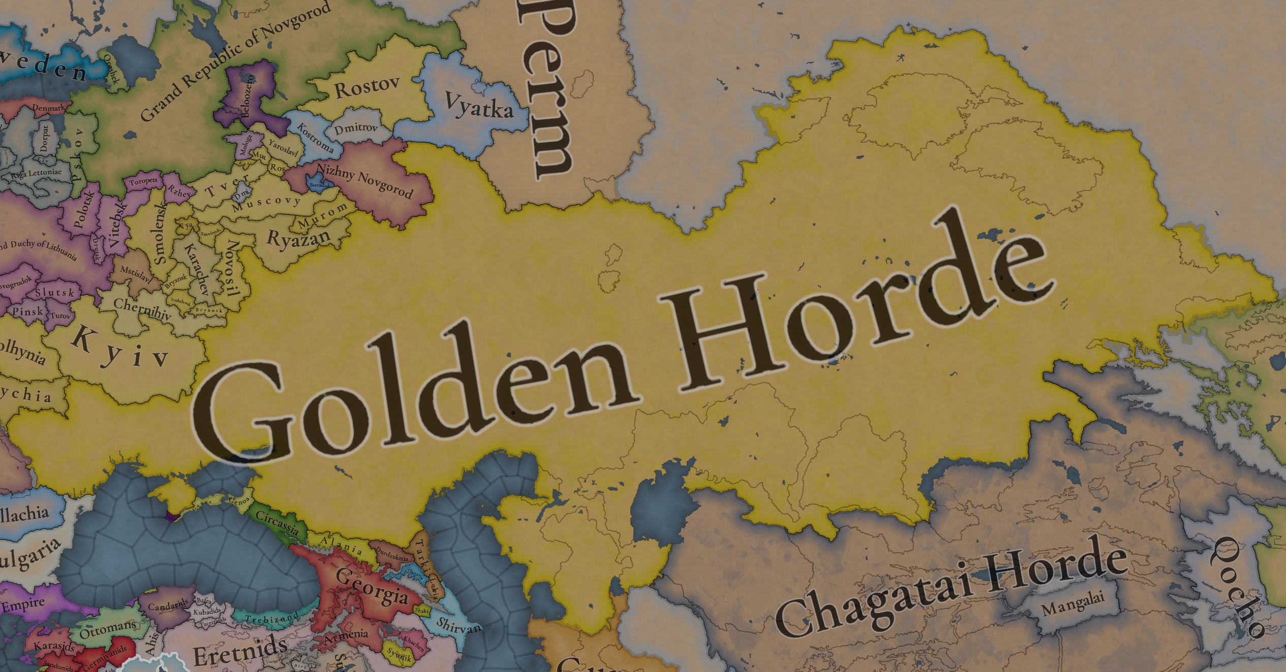
Hello, and welcome one more week to the weekly encounter for map lovers! This week it’s also directed at horse lovers because we will be looking at the Eurasian Steppes, plus the Urals! So let’s start with the maps without further ado.

Countries:
Countries.jpg

Colored Wastelands.jpg

A glorious, Golden Horde! It is at its power peak, under the reign of Uzbeg Khan, so it's a much more menacing presence for its neighbors. However, it has its some internal issues that need to be managed, as you’ll notice in some of the maps, and in the future when we talk about the content for Hordes. The Golden Horde also heads its own IO, the Tatar Yoke, as shown in a previous Tinto Maps:

Tatar Yoke.jpg

We have already corrected the Ruthenian countries that are under the Horde’s Yoke, although we still have to correct the Russian principalities, which will be done in the corresponding Tinto Maps review. We’re also aware that we need to improve a bit the coloring of the IO, to mark not only the Golden Horde as the overlord of these countries, but also that Muscovy holds the title of the Grand Principality of Vladimir, which makes it the ‘enforcer’ of the Yoke. These fixes are also planned to be done in a few weeks.

Societies of Pops:
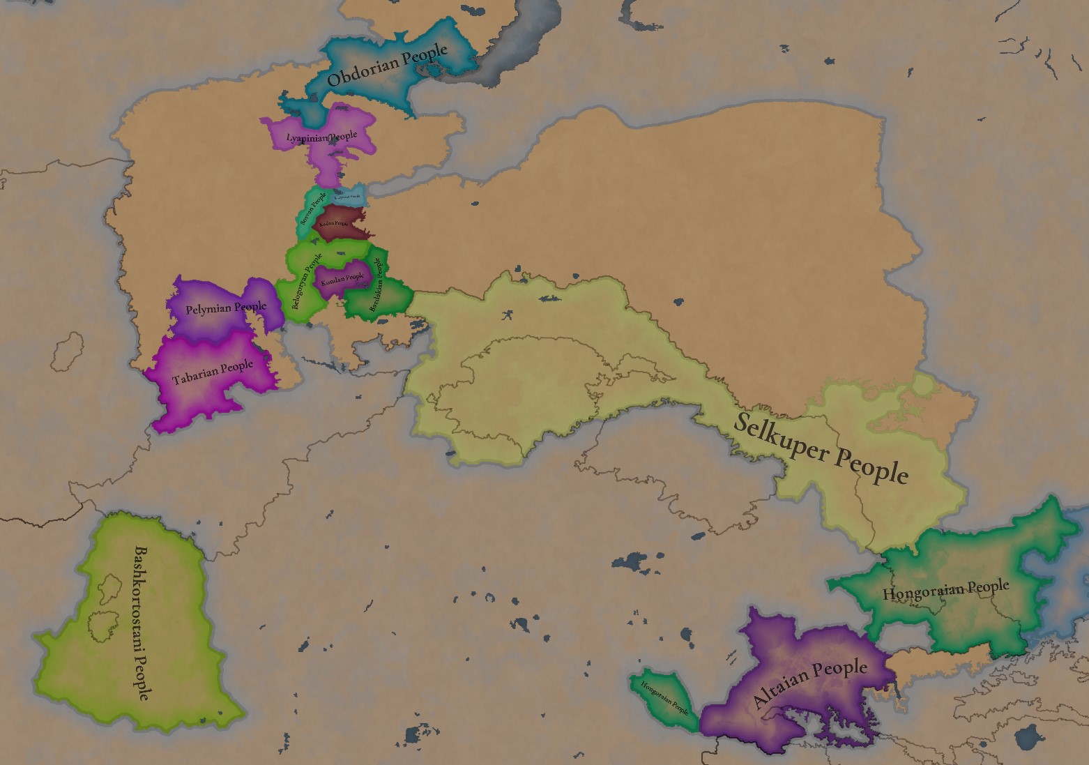
Societies of Pops.jpg

Societies of Pops 2.jpg .jpg

A bit up to the north, we have some Societies of Pops! This means that the territory of Western Siberia won’t be empty land, but will be populated by these people, which can be interacted with.

BTW, I’m not showing this week a dynasty map because, well, only the Borgijin dynasty rules over the lands of the Golden Horde, of course!


Locations:
Locations.jpg

Locations Western Siberia.jpg

Locations 3.jpg

Locations 4.jpg

Locations 5.jpg

Tons of locations today… You might notice that the density location is in a progression from west to east, from the most densely settled areas to the less settled ones. You may also notice that we’ve followed a design of ‘settler corridors’ in Western Siberia, setting those parts of the land that were habitable, usually on river valleys.

Provinces:
Provinces.jpg

Provinces 2.jpg


Areas:
Areas.jpg


Terrain:
Climate.jpg

Topography.jpg

Vegetation.jpg

The terrain is interesting here, as there are two main ecological areas. The first is the Steppes, Flatlands with Sparse and Grasslands vegetation, with either Cold Arid or Continental climates. And then we have the Siberian Arctics Forests, which are completely different, of course. On a note, the Urals were set as Hills, as they’re a quite settleable area, but we’ll probably make a review with your feedback, and add some mountains there.

Development:
Development.jpg

The whole region is not very developed, you might notice the difference with India, from last week’s Tinto Maps.

Harbors:
Harbors.jpg

There are some harbors in the Steppe region… In the Black Sea and Caspian Sea, of course! As usual, we’re open to feedback on this matter.

Cultures:
Cultures.jpg

Plenty of cultures! One note: Although we planned to work on the religious and cultural minorities of the region during the summer, we ended up not having enough time to add them. So what we’ll be doing today is showing the rough outline of ‘cultural spheres’, and then we’ll add the minorities during the review of the region. In that sense, feedback is very well received.

With that said the only note that needs to be made in terms of the cultural design is that we divided the Tatar cultural group into some differentiated regional cultures, being Crimean, Mishary, Kazani, and Astrakhani. We’re also aware that some of the cultures, as Mari and Chuvash, might be a bit displaced, as noted in the Russian Tinto Maps, so we’ll review and correct that with your feedback.


Religions:
Religions.jpg

Regarding Religions, the matter is a bit worse, as the big Sunni blob is just because the main religion of the Golden Horde is Islam, after the conversion of Uzbeg Khan, but that’s obviously incorrect. Also, as we have been able to forecast development time on how Pagan divisions will be during this autumn, we will make a comprehensive review of the region as well, to get a good distribution of ‘Shamanist’ Paganism, Tengrism, and Sunni Islam.

Raw Materials:
Raw Materials.jpg

Raw Materials 2.jpg

Raw Materials 3.jpg

Regarding the raw materials, the Steppes have plenty of Livestock and Horses, quite logically, although there are regions with some other goods. And up to the north, the main materials are Lumber and Fur. Apart from that, I want to mention the mineral hub in the Ural Mountains, with plenty of Copper, Iron, Gold, Lead, and Coal. That makes it a very mid and late-game interesting spot, and playing as Muscovy/Russia, I’ll tell you that you definitely want to expand into that region, as it will fulfill some of your material needs by that time.

Markets:
Markets.jpg

Markets! Big region, with lots of markets, although you may noticed that we changed the coloring of the locations that have 0% market access, which is the case in several areas. In any case, the market centers are Kaffa, Astrakhan, Saray-Jük, Kunya Urgench, Samarkand, Almaty, and Chimgi Tura. BTW, these names are much easier to notice in the game’s UI, as they’re beside the market centers:

Markets 2.jpg


Population:
Population.jpg

This week we’re showing only the country population mapmode, as there are some location numbers here and there which are failing, due to the already known issue with our pop editor (and which are on the way to be fixed). In any case, the whole population of the region is around 6.5-7M, of which around 6.3M are part of the Golden Horde. As I said, it’s a menacing country…

And that’s all for today! This is going to be my last Tinto Maps in a while, as I’ll be on vacation for 3 weeks during October (you might have noticed that I didn’t have any during summer), so one of the Content Designers in the team, @Roger Corominas , will step in and be in charge of the next 4 Tinto Maps. It’s in good hands, as Roger is an Experienced CD, who has been working and focused on Project Caesar for more than 3 years, at this point (this is why you might not know him from EU4, as other CDs in our team). In any case, he will be starting with the regions of Xinjiang, mostly ruled by the Chagatai Khanate, and Tibet.

I’ll keep reading and answering you during next week, and then I’ll be back in a month from now. See you!
 
  • 145Like
  • 48Love
  • 4
  • 3
  • 1Haha
Reactions:
Still, none of that proves that the lands were inhabited by Slavic people rather than at least Erzya and Moksha.
They should be mostly Erzya/Moksha majority maybe with the exception of Tambov. Pavlovo and Ardatov were part of Murom principality, so some Russian pops would make sense. Kadom as you said is not too far from Kasimov, so some radiation to that area is to be expected as well. Tsna was settled by Russians 13th century onward and they coexisted with Mordvins in the area.
1733924140704.png

 
  • 1Love
Reactions:
My long overdue topographical analysis!

Despite my tardiness, there are not that many changes I would suggest.
Summary:
  • Southern Urals are not terribly rugged. There are plenty of broad, flat passes from the West towards modern Yekaterinburg, where it's almost flatlands (and actually rolling hills at best in many spots).
    • Although not on the location map, Northernmost Ural crossing should need hills/mountains!
  • Morkvash location is an interesting, isolated smaller hill massif that should definitely make it on the map imo.
  • The Vasyugan Swamp is apparently the largest swamp of the Northern hemisphere, and the largest peatlands in the world.
    • This warrants a few more wetlands around the region, as also indicated by other sources
  • Northern Kazachstan has a lot of small lakes and ponds, and are not wetlands sensu strictu. I can definitely relate to this indication so I'd keep them.
  • The Kazakh Uplandsare not terribly rugged, and a mountain indication for Karkaraly is excessive.
    • that said, the whole region is definitely significantly elevated, enough to be considered a plateau in game terms
    • Perhaps the locations around Karkaraly could be reshaped a bit to fit the hilly region a bit better?
      • (I have no clue on the historical accuracy of my suggested borders though)
  • Some other smaller wetland suggestions (i made them blue on my maps as I have difficulty distinguishing the green wetlands from hills)
Suggestions
Current designSuggested design'Changelog' of suggestions
TopoCurrent.png
TopoSuggested.png
TopoChangelog.png

Elevation sources
Terrain Ruggedness Index (note that a lot of 'wetlands' in the southern half are located in more arid regions, and thus aren't very wet IRL)DEM with exaggerated colors
DEM-TRI.png
DEM-Colorful.png

Wetlands
Types of Wetlands according to Global Lakes and Wetlands database. Note that peatlands are greatly exaggerrated here.Abundance of Peatlands in area %, according to PeatMLWater depth during 100 year flood events (proxy for flood risk)
Wetlands_GLWD.png
Wetlands_PeatML.png
Wetlands_Floods.png
 
  • 9Like
  • 2Love
  • 1
Reactions:
Since you guys said that you were going to do Perm and Vyatka in this tinto maps and not Russia I just want to mention the fact that in 1337 there were two different principalities of Perm, Great Perm and Little Perm/Vychegda Perm named after the river where it was situated, although the first one is indipendent in 1337 the second one is most definitely a vassal of Veliky Novgorod
 
  • 2Like
  • 2
Reactions:
This area of Mangyshlak should be Turkmen in this time period. Those turkmens would later be moved to Kalmykia and Astrakhan by Kalmyk khanate and now are known as Stavropol Turkmens.

1735635311152.png
 
  • 2Like
  • 2
Reactions:
My suggestions for Western Siberia
1735754169073.png


1735754104936.png

1735754324442.png

1735754344329.png

1735754385545.png

1735754545185.png

https://journal.archaeology.nsc.ru/jour/article/view/683/637
https://cyberleninka.ru/article/n/ob-ochen-drevney-istorii-yazycheskogo-belomorya
 
  • 4
  • 1
Reactions:
My suggestions for Western Siberia
View attachment 1238236

View attachment 1238235
View attachment 1238238
View attachment 1238239
View attachment 1238241
View attachment 1238247
https://journal.archaeology.nsc.ru/jour/article/view/683/637
https://cyberleninka.ru/article/n/ob-ochen-drevney-istorii-yazycheskogo-belomorya
I believe Bashkirs and Magyars are incorrect in your proposal.
 
Last edited:
I believe Bashkirs and Magyars are incorrect in your proposal.
I based it off of mostly these maps
1735764967774.png

1735764985330.png

With that we can make something like this
1735771525684.png

The eastern border hugs the Ural mountain range. If there is another dominating burial rite, then that takes precedence. Along the Iset and Miass, Bakal and Yudin dominate and thus the area should be Mansi. Beyond the Urals and the Ural river Golden Horde nomads dominate. Udmurts are predominant across the Kama. Chelyabinsk has evidence of Kipchaks as far back as the Magyar era, so the border between Mansi and Tatars could vary. To the west lie the still heavily populated remains of Volga Bulgaria and the Bugulma-Belebeevskaya highlands, which weren't attractive to any party until pressure was put on the Bashkirs to migrate northward by the Golden Horde.

Chiyalik culture descends from the Post-Petrogrom culture, which in turn came from the Yudin culture of the Iset river in the 10th century, assimilating the remaining Kushnarenkovo-Karayakupovo culture people. Yudin culture coexisted with the Bakal culture, which was heavily Turkicized but still Ugric. Arguably these all could be somewhat related to Magyars, as they descend from Sargat culture.

As for the Bashkirs, their archaeological understanding is quite poor. Clearly they should be associated with the Pechenegs and their burial sites. The Pecheneg burial rite would place the deceased in a mound facing west, and to the left of the person would be a horse carcass also westward facing.

1735765931869.png


In the subsequent eras associating any burials with the Bashkirs in specific becomes very difficult. Not to mention that in the eastern areas that are traditionally thought to be Bashkir or the upper reaches of the Ural river, there were Mongols who buried their dead in stone kurgans and didn't produce stone statues like the Kipchaks in the west. Perhaps by this time the Bashkirs had been assimilated into the Kipchaks, and they would have been located in the Kipchak zone in the west.

1735766244323.png

1735766265905.png

1735766309879.png


Here's some reading on the topic for the devs, I hope it proves to be helpful.
 
I based it off of mostly these maps
View attachment 1238286
View attachment 1238287
With that we can make something like this
View attachment 1238315
The eastern border hugs the Ural mountain range. If there is another dominating burial rite, then that takes precedence. Along the Iset and Miass, Bakal and Yudin dominate and thus the area should be Mansi. Beyond the Urals and the Ural river Golden Horde nomads dominate. Udmurts are predominant across the Kama. This is a rather minimalist take especially toward the northeast. Although Chelyabinsk has evidence of Kipchaks as far back as the Magyar era. To the west however lie the heavily populated remains of Volga Bulgaria and the Bugulma-Belebeevskaya highlands, which weren't attractive to any party until pressure was put on the Bashkirs to migrate northward by the Golden Horde.

Chiyalik culture descends from the Post-Petrogrom culture, which in turn came from the Yudin culture of the Iset river in the 10th century, assimilating the remaining Kushnarenkovo-Karayakupovo culture people. Yudin culture coexisted with the Bakal culture, which was heavily Turkicized but still Ugric. Arguably these all could be somewhat related to Magyars, as they descend from Sargat culture.

As for the Bashkirs, their archaeological understanding is quite poor. Clearly they should be associated with the Pechenegs and their burial sites. The Pecheneg burial rite would place the deceased in a mound facing west, and to the left of the person would be a horse carcass also westward facing.

View attachment 1238291

In the subsequent eras associating any burials with the Bashkirs in specific becomes very difficult. Not to mention that in the eastern areas that are traditionally thought to be Bashkir or the upper reaches of the Ural river, there were Mongols who buried their dead in stone kurgans and didn't produce stone statues like the Kipchaks in the west. Perhaps by this time the Bashkirs had been assimilated into the Kipchaks, and they would have been located in the Kipchak zone in the west.

View attachment 1238293
View attachment 1238294
View attachment 1238295

Here's some reading on the topic for the devs, I hope it proves to be helpful.
RAAAAAH ACHIEVEMENT: FORM HUNGARY AS URALIC MAGYAR NATION
 
  • 1Haha
Reactions:
I based it off of mostly these maps
View attachment 1238286
View attachment 1238287
With that we can make something like this
View attachment 1238315
The eastern border hugs the Ural mountain range. If there is another dominating burial rite, then that takes precedence. Along the Iset and Miass, Bakal and Yudin dominate and thus the area should be Mansi. Beyond the Urals and the Ural river Golden Horde nomads dominate. Udmurts are predominant across the Kama. Chelyabinsk has evidence of Kipchaks as far back as the Magyar era, so the border between Mansi and Tatars could vary. To the west lie the still heavily populated remains of Volga Bulgaria and the Bugulma-Belebeevskaya highlands, which weren't attractive to any party until pressure was put on the Bashkirs to migrate northward by the Golden Horde.

Chiyalik culture descends from the Post-Petrogrom culture, which in turn came from the Yudin culture of the Iset river in the 10th century, assimilating the remaining Kushnarenkovo-Karayakupovo culture people. Yudin culture coexisted with the Bakal culture, which was heavily Turkicized but still Ugric. Arguably these all could be somewhat related to Magyars, as they descend from Sargat culture.

As for the Bashkirs, their archaeological understanding is quite poor. Clearly they should be associated with the Pechenegs and their burial sites. The Pecheneg burial rite would place the deceased in a mound facing west, and to the left of the person would be a horse carcass also westward facing.

View attachment 1238291

In the subsequent eras associating any burials with the Bashkirs in specific becomes very difficult. Not to mention that in the eastern areas that are traditionally thought to be Bashkir or the upper reaches of the Ural river, there were Mongols who buried their dead in stone kurgans and didn't produce stone statues like the Kipchaks in the west. Perhaps by this time the Bashkirs had been assimilated into the Kipchaks, and they would have been located in the Kipchak zone in the west.

View attachment 1238293
View attachment 1238294
View attachment 1238295

Here's some reading on the topic for the devs, I hope it proves to be helpful.
I do not agree that Bashkirs should be solely associated with Pechenegs, as the second paper you quoted in the Abstract talks about Chiyalik culture as ancestors of Bashkirs.
1735808125966.png


However, I do find this interesting
1735808323549.png

1735808840110.png

saying that the consensus is that the Chiyalik culture was Ugric speaking. And in the first half of XII, a big wave of Kipchak-speaking people migrated here, assimilating locals.

I believe it can be portrayed in some way, making animistic Ugric speakers assimilate into muslim Bashkirs.

1735810654709.png

Here it says that in the XII-XIV centuries, animism was already extinct and replaced with Islam.

I guess the assimilation process in 1337 was already on the way.
As I understand in the XV century Chiyalik culture went almost fully extinct. Also marking an end to Ugric speakers.
So, I think in 1337 Bashkirs should be a majority in at least densely populated areas (near river Belaya until it meets Ufa river).
(All of that is my speculation tho)
 
Last edited:
  • 1Like
Reactions:
I do not agree that Bashkirs should be solely associated with Pechenegs, as the second paper you quoted in the Abstract talks about Chiyalik culture as ancestors of Bashkirs.
View attachment 1238393

However, I do find this interesting
View attachment 1238394
View attachment 1238399
saying that the consensus is that the Chiyalik culture was Ugric speaking. And in the first half of XII, a big wave of Kipchak-speaking people migrated here, assimilating locals.

I believe it can be portrayed in some way, making animistic Ugric speakers assimilate into muslim Bashkirs.

View attachment 1238404
Here it says that in the XII-XIV centuries, animism was already extinct and replaced with Islam.

I guess the assimilation process in 1337 was already on the way.
As I understand in the XV century Chiyalik culture went almost fully extinct. Also marking an end to Ugric speakers.
So, I think in 1337 Bashkirs should be a majority in at least densely populated areas (near river Belaya until it meets Ufa river).
(All of that is my speculation tho)
The adoption of Islam alone didn't lead to the extinction of Chiyalik culture, it was simply a development of their culture. The location of Chekmagush had their largest settlement Ufa-2, so that should absolutely be Chiyalik culture.

The Bashkirs should be associated with Kipchaks instead, who assimilated them. The location of Chismy could be mixed as there's evidence of nomads there, or there could be a new location there instead.
1735833383298.png

1735832881903.png


The Syntyshtamak burial ground could potentially be associated with the Bashkirs, as it has analogies with the Pechenegs.
 
Last edited:
The adoption of Islam alone didn't lead to the extinction of Chiyalik culture, it was simply a development of their culture. The location of Chekmagush had their largest settlement Ufa-2, so that should absolutely be Chiyalik culture.
In the article you quoted after this statement
датируются XII- XIV вв. Носители чияликской культуры по происхождению
являлись уграми, подвергавшимися активной тюркизации и исламизации.
So I think they can’t be fully Magyar as Ugric speakers did go extinct at some point. I can not find it reasonable to believe that all of them changed together to Bashkir at XVI century (when Russia started conquering those lands)
не только те земли, где они прежде подданства своего …жили, а именно — за Камою рекою и около Белой Волошки (кой после Белою рекою названа), им, башкирцам, подтверждены
 
In the article you quoted after this statement

So I think they can’t be fully Magyar as Ugric speakers did go extinct at some point. I can not find it reasonable to believe that all of them changed together to Bashkir at XVI century (when Russia started conquering those lands)
Keep in mind that the Bashkir language itself only formed in the 19th century from Volga Türki, which is also the immediate ancestor of Volga Tatar. Thus it was not only the Chiyalik but also the Pecheneg Bashkir who were assimilated by the Tatars. On top of this, 12th-14th century was the heyday of the Chiyalik peoples and thus they would have still been Ugric speakers at this time. I believe it is perfectly reasonable to say that they were Tatarized after the Golden Horde had collapsed. Russia only arrived here 200 years after game start, so that is plenty of time. And it also coincides with extinction of the Chiyalik culture as an indpendent group.
 
The article also agrees
Monuments of the Turkic-speaking Kipchak nomads of the the XIII-XIV centuries are known in small numbers in the southeastern regions of Tatarstan (Bayryaki-Tamak burial ground in the Bavli district, stone women near the village of Staroe Ursaevo in the Aznakaevsky district, the village of Maloe Urussu in the Bavli district, etc.)[14, pp. 93-96]. It is assumed that in the XV-XVI centuries this population penetrated further north and displaced or assimilated the remnants of the Ugric tribes [14, p- 98]. Ugrians lived in the lower reaches of the Belaya and Ik rivers at least until the second half of the fourteenth century. According to archaeological data, the process of displacement or absorption of this population by the late Turkic-speaking nomads is no longer traceable, it is only known that at the end of the 17th century the territory of the Chiyalik culture was inhabited by Bashkir tribes and Kazan Tatars who lived with them [14, p- 99].

Thus, the speakers of the Chiyalik culture lived side by side with the Kipchaks, but obviously did not mix with them. The settlement of the Kipchaks in the area of the Chiyalik culture, accompanied by the displacement or absorption of the local population, dates back to a later time - XV-XVI centuries. However, the Chiyalik culture no longer existed at that time, and the Chiyalik monuments do not extend beyond the tenth century. There was no Golden Horde at that time, which broke up into separate states, and the territory of the former Chiyalik culture was under the rule of the Kazan Khanate and the Nogai Horde. The archaeological sites of this period have been poorly studied, and the period itself is no longer included in the chronological framework of the topic under consideration.
 
  • 1
Reactions:
Have you already checked the more detailed location maps, under the Spoiler button?
Oh, damn, I didn't even notice this response back in September.
Yes, I did check the more detailed maps under the spoiler button but there are still many unreadable location names in Southern Ukraine, that's why I made my request.
In the recent Tinto Maps Extra you encouraged people to ask for more detailed maps under the appropriate TM posts so I ask again: can we get a locations map centred on the area between the Dniester and the Don, pretty please?
Hey, I can help with the request.
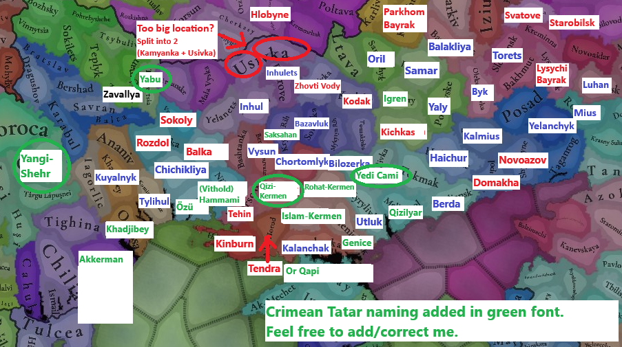
Those 7 locations you probably struggle to recognise are Kominternivske, Chervony Mayak, Novovoskresenske (not 100% sure), Velyka Bilozerka, Velyka Lepetykha, Hornostaivka and Velyka Novosilka :)
Zoom1.PNG


I have done a big feedback post on the area here in the comments and proposed some better names for 1337, easier to read, more historic, more relevant.
You can have a look here if you want:
LOCATIONS
Obviously, most of the Steppe territory was almost empty without any settlements there, so you had to choose the location names that were founded centuries later after 1337. There could be just some better choices that are shorter, better to read or more correct.
Where possible I will add Crimean Tatar names for dynamic naming, so you can use them in 1337 at the start:

You'll also find the names of almost all locations in that post.
Locations.png
Locations CrT.png
 
Last edited:
  • 5Like
  • 2Love
Reactions:
As long as I had some time for a deeper research, I made an update to my feedback on Severia.
Also as long as this region always appears divided on the edges of the three TMs (Ruthenian, The Steppes, Russian), I will post this update in all three threads, sorry.
I will post here only the updated parts from the post.

____________________

DEVELOPMENT & POPULATION
  • It was probably adjusted just by the climate/vegetation, but development and population should be higher around the duchies' capital locations (Chernihiv, Novhorod-Siversky, they have the lowest development in their duchies for some reason).
  • Also Putyvl and Ovruch vere quite important centres of the Kyivan land in the first half of the XIV century according to 'Ukraine under the Tatars and Lithuania' (Rusyna O.V.,1998), (pages 32, 33 and 35) and should have higher development and population compared to others:
Putyvl.png

Putyvl1.png

Though, concerning the fate of the princes of Putyvl [after the Mongol invasion], there are at least some sources on them in the Novohorod-Siversky church notes (or 'synodyk', that was called 'a bright ray in the dark times of Kyiv after the Batu invasion'). Synodyk mentiones [Kyivan princes] Ivan (Ioann) of Putyvl, his son Ivan-Volodymyr Ivanovych of Kyiv, Andriy of Ovruch (could be the brother of the latter) and his son Vasyl (that was killed in Putyvl) [those are the princes of the first quarter of the XIV century, around 1290 – 1325, as mentioned in the second screenshot].
Probably after having secured the Kyiv throne, Putyvl princes established a strong connection between Kyiv and their 'fatherland', its traces are then observed for the next 200 years. In the acts of the second half of the XV century it was mentioned that Putyvl taxes went to Kyiv and that all Putyvl governors were Kyivan nobles only.
Then (after the Lithuanian-Moscow peace of 1503) Kyivan elites send petitions to the Polish/Lithuanian king Sigismund I the Old that they were very disappointed with the loss of Putyvl that was 'Kyivan holding with 14 volosti around it...'

Ovruch.png

The fact that Ovruch had its own prince meant that it had become quite an important (maybe the second after Kyiv) administrative centre of the Kyiv land in the XIV century. Probably due to the fact that Kyiv lost control of the South, where the Tatars had direct rule.

So I think that these things should be taken into account, Putyvl and Ovruch should have higher development, population and attention within the Kyiv land.
And Chernihiv, Novhorod-Siversky as the capital towns of their duchies:
Development.png


I also think that Chernihiv and Bryansk should be towns due to their historic and regional importance (instead of Kursk that was completely burnt by the Horde twice during 50 years before the game start date).
If Norway has 6 towns, including Hamar with ~6 thousand population, then I think Chernihiv and Bryansk can be towns too.

COUNTRIES
  • Novgorod-Seversky should be Novhorod-Siversky to correspond with the respective location and Ukrainian dialect in the game. Also even though there are no exact data about its ruler, but it should be probably also a random Rurikovych Dynasty guy (probably from the Chernihiv branch), not just a random guy
NS.png
Countries.png
  • Kyiv, Halych, Volhynia, Chernihiv, Novhorod-Siversky (at least these, maybe some other too) should pay tribute to the Golden Horde directly, not via Ivan Kalita. I don't know if it is implemented in the Tatar Yoke IO. but Chernihiv, Kyiv, Kursk other Severian duchies had their ows baskaks from the Horde who collected the tribute to the Horde.

LOCATIONS
  • Please, add Lubech location, or at least rename Ripky to Lubech. Lubech is an ancient town known since the X century, that hosted Council of Lubech (in 1097). Ripky is just a random village first mentioned in 1607:
Lubech.png
Ripky.png
  • I have noticed that Belarusian locations have different transliteration rules, probably should be unified:
Locations_BelTranslit.png


PPROVINCES
The provinces in the region are not perfect:
  • Trubchevsk has a really weird form, while the nearby Kursk is much bigger that the others
  • Putyvl belonging to the Trubchevsk province is not natural at all
  • Novgorod-Seversky is a Russian transliteration, while everything else is Ukrainian (including the respective location)
Provinces_Bad.png

I suggest:
  • Correct the name of Novgorod-Seversky to Novhorod-Siversky or better to Southern Severia to avoid transliteration bias, together with Starodub to Northern Severia, Trubchevsk to Eastern Severia
  • Transfer Putyvl to Southern Severia, where it naturally belongs to (e.g., the prince Igor Svyatoslavovych in 'The Tale of Igor's Campaign' was the prince of Novhorod-Siversky. His wife was waiting for the prince in Putyvl)
  • Transfer Kosozhichi and Fatezh from Kursk to Eastern Severia/Trubchevsk
  • This way all the provinces will have 6-7 locations and the borders look nice and natural:
Locations_Provinces.png
Provinces_Proposed.png


AREAS
Areas need an important rework too:
Areas_Better.png
  • Firstly, Gomel province should belong to Severia. The Dnipro river makes a perfect natural border between the Black Ruthenia and Severia here. Gomel had been a core holding of Chernihiv for centuries and was considered as Severia. You portraied it perfectly in the cultures map btw.
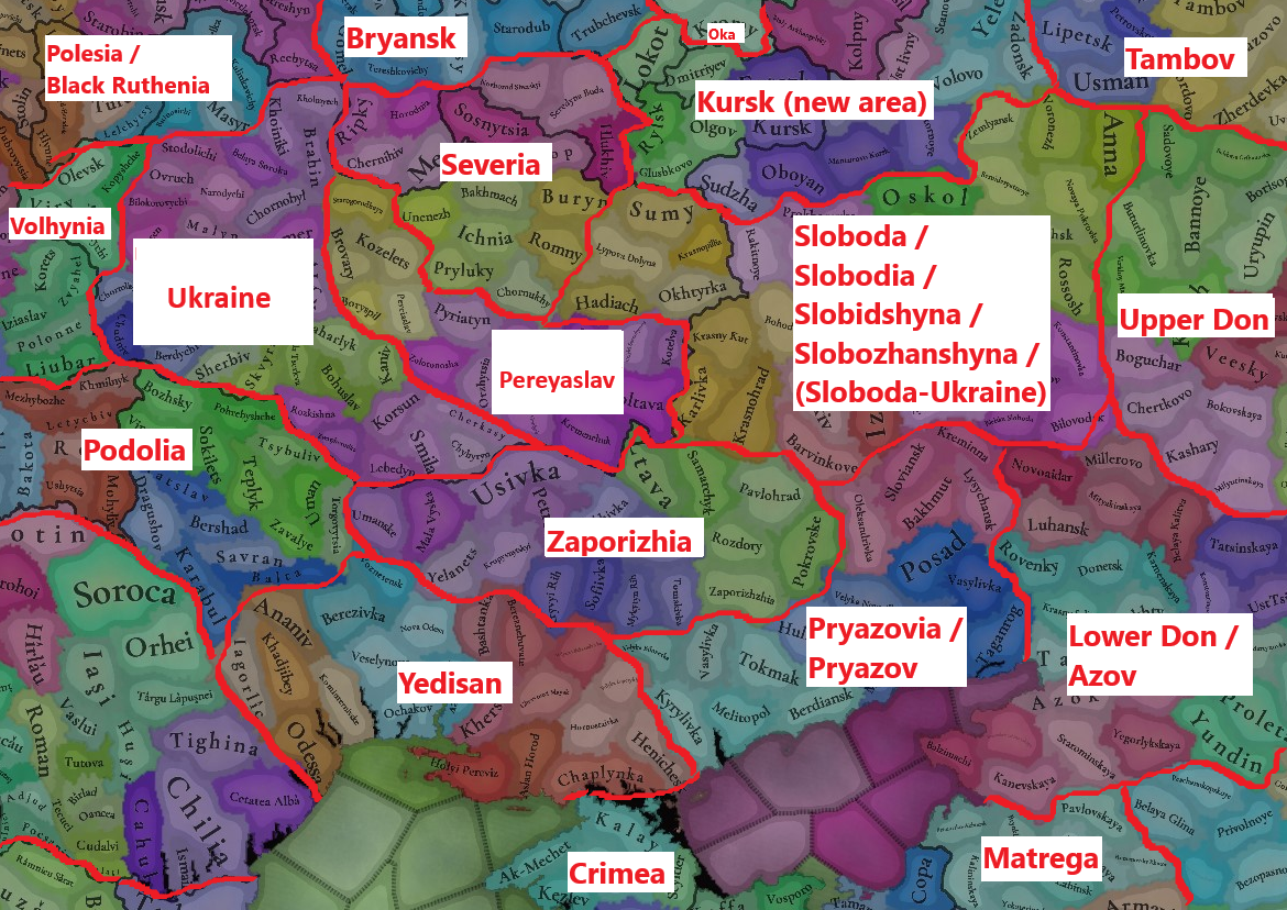
  • Secondly, Sloboda Ukraine goes way too far to the north and include the lands that has never been Sloboda-Ukraine. This area should be renamed to the Kursk Area. And Sloboda(-Ukraine) must be created on its historical lands to the south of this Kursk Area
  • Concerning the Sloboda-Ukraine I made a suggestion in the Steppes TM, this is where it belongs (trust me, I come from Sloboda-Ukraine :) ):
Areas.png
Lastly, I liked that Kyiv area was called Ukraine, I don't know why you changed it. East/West Dnipro are probably the worst possible options just because there are more historical or flavourful alternatives:
  • The lands around the Dnipro were never referred to as West/East in chronicles or the people.
  • Those were either the Right/Left Bank or just Kyiv Land/Pereyaslav Land (Київська Земля, Переяславська Земля).
  • It was definitely referred to as Ukraine already by the 1500s because the name Ucrania firsty appeared in the European (French) travel map, in the mid-XVI century. That means the locals started to call this land Ukraine much earlier, quite early within the game time frame.
  • The word Ukraine itself firstly appeared in cronicles of 1189, then 1214 and later on, so there is no problem with calling the area Ukraine, and on the other side Pereyaslav (see the map above)
Ukraine.png
  • That is why I also think that White Ruthenia area can be also called Belarus, as long as this is literally what it means
 
Last edited:
  • 7Love
  • 5Like
Reactions:
These stone kurgans were apparently left by Mongols or Mongol influenced Turks, such as Naimans. So these areas should be Mongol, Kerait, Naiman or Oirat.
1736121860735.png

1736122036386.png

 
  • 1
Reactions:
Also should Tatars be split?
Nogai is an ethnonym that did exist, but it wasn't concentrated in the area of the future Nogai horde yet. Khworezm should be Karluk/Chagatai/Khwarezmian and Mangystau should be Turkmen. The Bulgar Ulus still had Bulgars at this time so Kazani shouldn't exist either. Most of the Mishary territory is either Russian or Mordvin and Siberian Tatar definitely should not exist yet, as the area was still Ob Ugric at this time. And as I posted above, there shouldn't even be any Kipchaks east of Emba at all at this time.
So that leaves only Crimean, Astrakhani and the remains of Mishary, Kazani and Nogai. I think uniting these to a single Cuman or Kipchak culture would work fine, as the locations are quite large and the population size is quite small. There were not that many cultural differences among the different Kipchaks of the time that lived in the Golden Horde. And as I have shown there were Mongols even west of the Ural river too. There were also Genoese traders in places like Tana at this time, so there's plenty of cultural diversity to be had.
 
  • 3
  • 1
Reactions:
Also should Tatars be split?
Nogai is an ethnonym that did exist, but it wasn't concentrated in the area of the future Nogai horde yet. Khworezm should be Karluk/Chagatai/Khwarezmian and Mangystau should be Turkmen. The Bulgar Ulus still had Bulgars at this time so Kazani shouldn't exist either. Most of the Mishary territory is either Russian or Mordvin and Siberian Tatar definitely should not exist yet, as the area was still Ob Ugric at this time. And as I posted above, there shouldn't even be any Kipchaks east of Emba at all at this time.
So that leaves only Crimean, Astrakhani and the remains of Mishary, Kazani and Nogai. I think uniting these to a single Cuman or Kipchak culture would work fine, as the locations are quite large and the population size is quite small. There were not that many cultural differences among the different Kipchaks of the time that lived in the Golden Horde. And as I have shown there were Mongols even west of the Ural river too. There were also Genoese traders in places like Tana at this time, so there's plenty of cultural diversity to be had.
It doesn’t go with splits they did with with Polish cultures, Ruthenian split or even German (3 Bavarian cultures instead of 1).

I feel like current position is to split as much as possible, as there are culture groups and languages which are more general.
 
  • 3
Reactions:
It doesn’t go with splits they did with with Polish cultures, Ruthenian split or even German (3 Bavarian cultures instead of 1).

I feel like current position is to split as much as possible, as there are culture groups and languages which are more general.
I am not opposed to the idea of splitting Tatar cultures, but the current splits make little sense for the time of the game.