• We have updated our Community Code of Conduct. Please read through the new rules for the forum that are an integral part of Paradox Interactive’s User Agreement.

Tinto Maps #20 - 27th of September 2024 - The Steppes

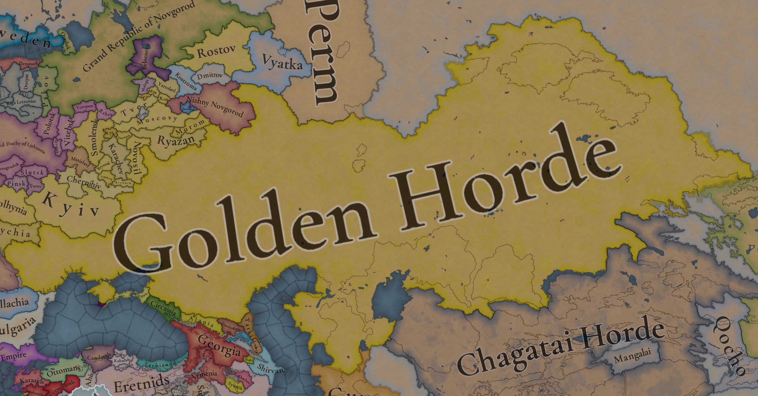
Hello, and welcome one more week to the weekly encounter for map lovers! This week it’s also directed at horse lovers because we will be looking at the Eurasian Steppes, plus the Urals! So let’s start with the maps without further ado.

Countries:
Countries.jpg

Colored Wastelands.jpg

A glorious, Golden Horde! It is at its power peak, under the reign of Uzbeg Khan, so it's a much more menacing presence for its neighbors. However, it has its some internal issues that need to be managed, as you’ll notice in some of the maps, and in the future when we talk about the content for Hordes. The Golden Horde also heads its own IO, the Tatar Yoke, as shown in a previous Tinto Maps:

Tatar Yoke.jpg

We have already corrected the Ruthenian countries that are under the Horde’s Yoke, although we still have to correct the Russian principalities, which will be done in the corresponding Tinto Maps review. We’re also aware that we need to improve a bit the coloring of the IO, to mark not only the Golden Horde as the overlord of these countries, but also that Muscovy holds the title of the Grand Principality of Vladimir, which makes it the ‘enforcer’ of the Yoke. These fixes are also planned to be done in a few weeks.

Societies of Pops:
Societies of Pops.jpg

Societies of Pops 2.jpg .jpg

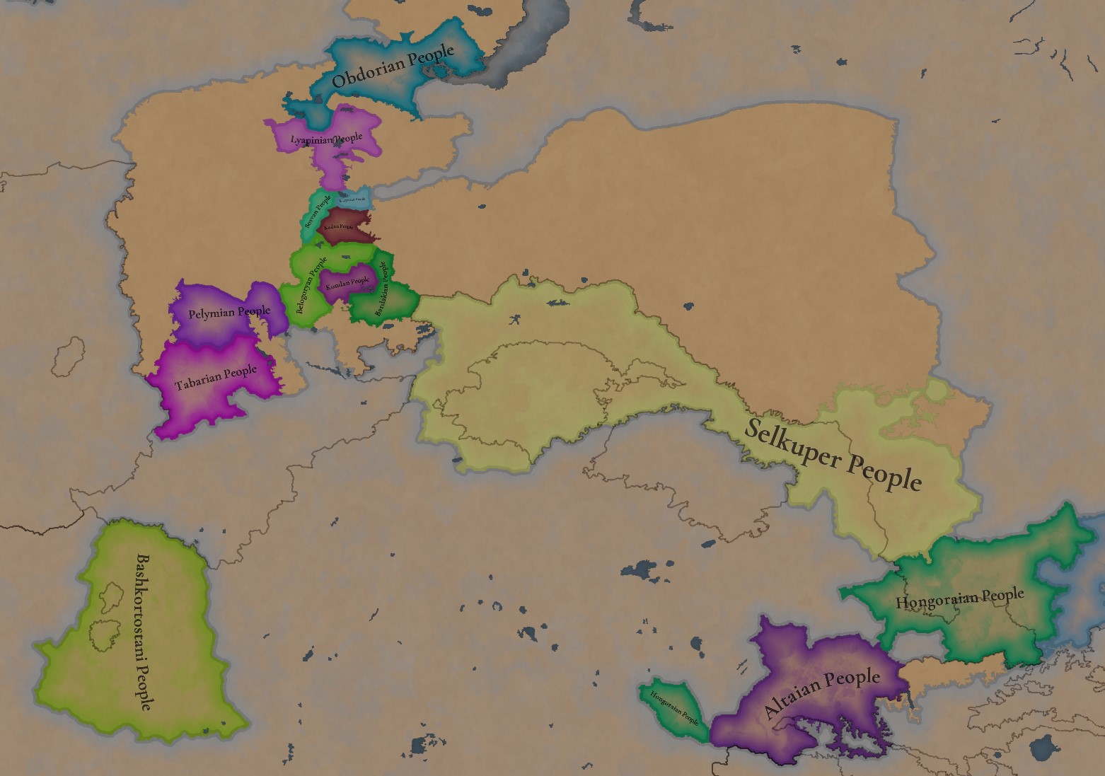
A bit up to the north, we have some Societies of Pops! This means that the territory of Western Siberia won’t be empty land, but will be populated by these people, which can be interacted with.

BTW, I’m not showing this week a dynasty map because, well, only the Borgijin dynasty rules over the lands of the Golden Horde, of course!


Locations:
Locations.jpg

Locations Western Siberia.jpg

Locations 3.jpg

Locations 4.jpg

Locations 5.jpg

Tons of locations today… You might notice that the density location is in a progression from west to east, from the most densely settled areas to the less settled ones. You may also notice that we’ve followed a design of ‘settler corridors’ in Western Siberia, setting those parts of the land that were habitable, usually on river valleys.

Provinces:
Provinces.jpg

Provinces 2.jpg


Areas:
Areas.jpg


Terrain:
Climate.jpg

Topography.jpg

Vegetation.jpg

The terrain is interesting here, as there are two main ecological areas. The first is the Steppes, Flatlands with Sparse and Grasslands vegetation, with either Cold Arid or Continental climates. And then we have the Siberian Arctics Forests, which are completely different, of course. On a note, the Urals were set as Hills, as they’re a quite settleable area, but we’ll probably make a review with your feedback, and add some mountains there.

Development:
Development.jpg

The whole region is not very developed, you might notice the difference with India, from last week’s Tinto Maps.

Harbors:
Harbors.jpg

There are some harbors in the Steppe region… In the Black Sea and Caspian Sea, of course! As usual, we’re open to feedback on this matter.

Cultures:
Cultures.jpg

Plenty of cultures! One note: Although we planned to work on the religious and cultural minorities of the region during the summer, we ended up not having enough time to add them. So what we’ll be doing today is showing the rough outline of ‘cultural spheres’, and then we’ll add the minorities during the review of the region. In that sense, feedback is very well received.

With that said the only note that needs to be made in terms of the cultural design is that we divided the Tatar cultural group into some differentiated regional cultures, being Crimean, Mishary, Kazani, and Astrakhani. We’re also aware that some of the cultures, as Mari and Chuvash, might be a bit displaced, as noted in the Russian Tinto Maps, so we’ll review and correct that with your feedback.


Religions:
Religions.jpg

Regarding Religions, the matter is a bit worse, as the big Sunni blob is just because the main religion of the Golden Horde is Islam, after the conversion of Uzbeg Khan, but that’s obviously incorrect. Also, as we have been able to forecast development time on how Pagan divisions will be during this autumn, we will make a comprehensive review of the region as well, to get a good distribution of ‘Shamanist’ Paganism, Tengrism, and Sunni Islam.

Raw Materials:
Raw Materials.jpg

Raw Materials 2.jpg

Raw Materials 3.jpg

Regarding the raw materials, the Steppes have plenty of Livestock and Horses, quite logically, although there are regions with some other goods. And up to the north, the main materials are Lumber and Fur. Apart from that, I want to mention the mineral hub in the Ural Mountains, with plenty of Copper, Iron, Gold, Lead, and Coal. That makes it a very mid and late-game interesting spot, and playing as Muscovy/Russia, I’ll tell you that you definitely want to expand into that region, as it will fulfill some of your material needs by that time.

Markets:
Markets.jpg

Markets! Big region, with lots of markets, although you may noticed that we changed the coloring of the locations that have 0% market access, which is the case in several areas. In any case, the market centers are Kaffa, Astrakhan, Saray-Jük, Kunya Urgench, Samarkand, Almaty, and Chimgi Tura. BTW, these names are much easier to notice in the game’s UI, as they’re beside the market centers:

Markets 2.jpg


Population:
Population.jpg

This week we’re showing only the country population mapmode, as there are some location numbers here and there which are failing, due to the already known issue with our pop editor (and which are on the way to be fixed). In any case, the whole population of the region is around 6.5-7M, of which around 6.3M are part of the Golden Horde. As I said, it’s a menacing country…

And that’s all for today! This is going to be my last Tinto Maps in a while, as I’ll be on vacation for 3 weeks during October (you might have noticed that I didn’t have any during summer), so one of the Content Designers in the team, @Roger Corominas , will step in and be in charge of the next 4 Tinto Maps. It’s in good hands, as Roger is an Experienced CD, who has been working and focused on Project Caesar for more than 3 years, at this point (this is why you might not know him from EU4, as other CDs in our team). In any case, he will be starting with the regions of Xinjiang, mostly ruled by the Chagatai Khanate, and Tibet.

I’ll keep reading and answering you during next week, and then I’ll be back in a month from now. See you!
 
  • 146Like
  • 48Love
  • 5
  • 3
  • 1Haha
Reactions:
Probably until 1341 (before Uzbek's death) Bulgaria, Serbia, Blaquia (Wallachia), and Byzantium were in the tributary system of the Golden Horde. The North Caucasian countries definitely paid tribute all the time. The third option is the most suitable. But the translation fails, I don't quite understand what exactly you're representing. I presented your words like this:
1) There is a tribute zone, the countries in it pay a fixed tribute directly to the Golden Horde (until they win back their freedom). And if they don't pay, then the Golden Horde gets the casus belli "plunder", in which they have to get their money and at the same time take a lot of the population into slavery or ignore it and thereby lose the tribute zone.
2) Those tributary countries that have tributaries in this zone fall into the international organization - this is the Principality of Vladimir-Suzdal. But maybe not only that. I have not yet studied the question of whether the Slomen principality was formally similar from 1334 to 1340 (see the history of the Bryansk Principality); and we certainly will not have direct sources about the Magyar Ugra, but some indirect evidence (few excavations) suggests that it was significantly richer than its neighbors until it was definitively destroyed sometime after the 1370s or even later. Countries that have fallen into such a tribute no longer pay the Golden Horde on the first point.
3) The international organization also includes principalities that are half (or completely) part of the Golden Horde. For example, the most famous location is Tula, which was simultaneously part of the Golden Horde and the Pereyaslavl-Ryazan Principality. The member countries of the organization and the Golden Horde will have special interactions that have not yet been developed.
4) The successor states (or the union of uluses, if they have not completed the reforms to unite into a single Horde) receive their tributaries (if they have access to the location that supplies tribute) based on the results of a peace treaty in the war of independence from the center (while remaining in the Golden Horde system, allowing them to restore the Golden Horde if they absorb/they will subjugate other successor countries, as Tokhtamysh did by the end of the 14th century). For example, in 1312, the successor countries could be Kok-Horde Right Wing; Ak-Horde Right Wing; Ak-Horde Left Wing; Kok-Horde Left Wing. In later years, the issue of the receiving countries became more complex and ambiguous.
Do I understand you correctly? Or is it wrong? But let's say we have these wonderful uluses with wonderful rulers (work in progress). But as you may notice, a couple of them occupy a significant territory formally belonging to the Principality of Galicia. Alexa Moldaowicz is a vassal of the Principality of Galicia and at the same time a tributary of the Golden Horde. And there is also an independent Hungary with vassals paying tribute to the Golden Horde. How will these three specific cases be presented in the game?
Правители Молдавский Улус.png

In this case, I am most interested in the question concerning the Galician lands that are part of the uluses of the Golden Horde. How exactly should they look and work?
 
So, I want to raise the question of Yoke again

By my understanding of this


In the game, Muscovy will be an "enforcer" of tribute from Ruthenian lands. As Ruthenian lands are now also in the IO

But did this happen?
I believe Muscovy collected tribute from only from Russian principalities.

The Grand Principality of Vladimir is called that because of the Vladimir-Suzdal grand principality, which existed as a single entity, but later broke down into multiple states. However, the title survived being given to the small ones by the Golden Horde as a representative (Jarlig or Yarlyk - the edict by which GH appointed). The elected prince had the ability to collect tribute from the lands of the Vladimir-Suzdal principality lands(in a broader sense)

View attachment 1280937

So I believe this "enforcement" applied only to the lands of the Vladimir-Suzdal principality territory + Novgorod (as it had already joined by 1337, as I understand, here is a summary). So the suzerainty of that title was extended to only Novgorod and Pskov.


For example, let's take the Ryazan principality; there is a story like

So, they personally handled their tribute (not through the enforcer)

The last act of intervention of the Vladimir-Suzdal principality into the politics of the Southern principalities I found was in 1236

Maybe it is better to have Ruthenian principalities as tributaries and not part of the IO?
And there will be an IO called Vladimir-Suzdal grand principality, where the Golden Horde can elect the enforcer, giving them Jarlig(Yarlik). And the tribute will be collected by the enforcer. So the IO itself will be a singular "tributary" of the Golden Horde, which just happens to consist of multiple nations.

Or a third variant of IO participation that is not influenced by the Jarlig of the Grand Duchy of Vladimir title? So there will be direct Tributaries, and indirect ones, with an assigned enforcer for each indirect one. This can give some possible what-if scenarios, so the IO won't be as rigid as the first suggestion.
The IO of Tatak Yoke will remain (to also keep the historical authenticity). The general rule will be that every new state that is spawned from another will be a part of the Yoke

I personally like the first variant, as with something similar to Voting Laws in HRE IO, we can try to simulate the unification of those lands under the Moscow principality (without war on Novgorod like in EU4). But the second one can also work to open alternative history paths.

There can be laws to move countries between different types of tribute (like it is happened with Novgorod, which accepted suzerainty of the Great Duchy of Vladimir)

So I looked more into the Grand Principality title, and there have existed more than one with more. Also I found out more indications of „enforcement“

The Bryansk principality had the title of Grand Principality of Chernihiv; however, no mention of it being given to them by Yarlyk.
Same with Smolensk and the Grand Principality of Smolensk

In 1337 Smolensk was a center of Lithuania and Moscow fights. In 1340 Smolensk didn’t pay tribute and Moscow and Golden Horde invaded. Here is a clear role of „enforcer“ for Muscovy over other principalities.

In 1370 Moscow has fought with Lithuania over control in Bryansk.

And as I understand, this is the furthest it went. Southern Ruthenia principalities will be conquered before any control even reached those lands. So, perhaps the current portrayal is also „okay“? (Muscovy enforcing over entire Rus)

Interestingly Kyiv principality was not a Grand one. As I understand the invasion of hordes + a lot of infighting + Lithuania (and all of that in extreme succession) prevented formation of a similar title and structure.

After 14th century title of Grand principality started devolving, and was used by Yaroslavl and Tver.

So I believe the current choice for a name of „enforcer“ might be the best. (Grand principality of Valdimir) only other suggestion is «Всея Руси»(of all Rus) - this will make a parallel with Lithuanian title.


Additional info:

There is a lot of quotes, here for example, when Muscovy recieved/bought Yarlyk to rule over Murom, Novosil, Gorodets, etc. making then a union. Also wiki states that the previous rulers were alive, so Muscovy deposited the ruler and took the principality.
I think this should definitely be a mechanic in the Yoke IO to buy out other principalities for money.
 
Last edited:
  • 2Like
  • 2
Reactions:
I searched for copper in Moldavia, and found gold on the Don. The settled settlements of the Golden Horde on the Don! I wonder what the Greeks were doing so far north and the Russians so far south? Due to the low population density, they will be the dominant majority there and thus stand out on the map.
Нижний Дон.png
Донской улус.png


Thesepictures are inbetterqualityin the source, and thereareotherimportantdrawings there.

The Yelets Principality was ruled by the Kozelsk princes. Therefore, on the site of the Yelets Principality there should be an inscription Kozel Principality.
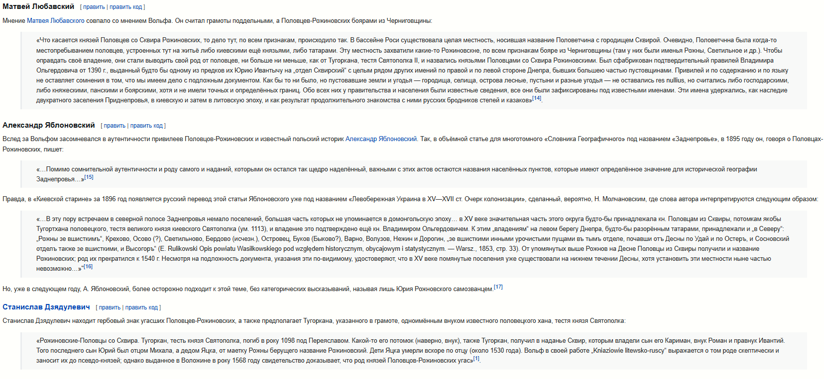
So, do you remember how we argued about the Pereyaslav region? We were all wrong! I accidentally found those who ruled the city-principality of Oster. Link. It turns out that their lands were more extensive. But the status of the Polovtsy-Rojanovtsy is unclear. Various researchers considered them to be vassals of the Chernigov Principality, the Kiev Principality, the Lithuanian Principality and a direct part of the Golden Horde. Their existence explains all the discrepancies that have appeared in the region.
половцы.png


Сквир.png


I think that Kariman will be the ruler in 1337. This territory is part of the Golden Horde and at the same time a vassal of Lithuania. If this is not possible according to the game mechanics, then at the beginning of the war (historically in 1356), an event will occur with the Mankerman Ulus / Golden Horde in which the territory will become a vassal of Lithuania, and at the end of the war, an event for annexation by the Kiev Principality.

The same article casually mentions the work of an-Nuwayri, which spoke about the population of the principality of "Dikoe Pole" (wild field), the Polovtsian dynasty of Terter-Oba existed there just before the 14th century. In the middle of the 13th century, the power in this principality went to the Kai-Oba dynasty. Well, then, you know, Mamai's son seized their lands, Mamai's grandson Skider expanded these lands, and since the 1390s, information about the wild field has been appearing. The "Sharukan" and "Pole" could be ruled by Polovtsian dynasties: Terter-Oba, Ete-Oba, Toks-Oba, Kol-Oba, Kai-Oba, Olberlu. However, I had previously seen a mention somewhere that Uzbek Khan had sent many Polovtsians to Bulgaria. Perhaps these lands were recently inherited by the Tatars. Or maybe not. To do this, first I need to find the local rulers.
 
  • 1
Reactions:
I searched for copper in Moldavia, and found gold on the Don. The settled settlements of the Golden Horde on the Don! I wonder what the Greeks were doing so far north and the Russians so far south? Due to the low population density, they will be the dominant majority there and thus stand out on the map.
Do you realize it's a book by a geophysicist and not a historian or a linguist? He might be good at mapping, I grant him that.
 
  • 2Like
Reactions:
LOCATIONS
Obviously, most of the Steppe territory was almost empty without any settlements there, so you had to choose the location names that were founded centuries later after 1337. There could be just some better choices that are shorter, better to read or more correct.
Where possible I will add Crimean Tatar names for dynamic naming, so you can use them in 1337 at the start:
I have made a minor correction of several suggestions so that their transliteration was in accordance with other locations with Ukrainian naming on the map (for dynamic spelling purposes, really hope that at te start date there will be more suitable Turkic location names):

Zavallia, Kuialnyk, Chichiklia, Balaklia, Parkhom-Bairak, Lysychiy Bairak
instead of
Zavallya, Kuyalnyk, Chichikliya, Balakliya, Parkhom Bayrak, Lysychi Bayrak.

Locations.png


Transliteration rules were posted in the Ruthenian map feedback here:
I got an idea to help and check transliteration from the Ukrainian language. I believe it should be based on the official standard (accepted by Ukraine and the UN) with a minor adjustment for better flavour.
 
  • 5Like
  • 1
  • 1
Reactions:
I have made a minor correction of several suggestions so that their transliteration was in accordance with other locations with Ukrainian naming on the map (for dynamic spelling purposes, really hope that at te start date there will be more suitable Turkic location names):

Zavallia, Kuialnyk, Chichiklia, Balaklia, Parkhom-Bairak, Lysychiy Bairak
instead of
Zavallya, Kuyalnyk, Chichikliya, Balakliya, Parkhom Bayrak, Lysychi Bayrak.

View attachment 1286773

Transliteration rules were posted in the Ruthenian map feedback here:
I really hope team and @Pavía will note this because I now see Caucasus feedback and even reviewed Circasia has obvious slavic-style locations, Abinskaya and Khadyzhensk are rusified local names. And still lots to the north.
This was quite disappointing to see. It ruins immersion especially if hundreds of these names will remain in Golden Horde..
Untitled.png
 
  • 8
  • 1Like
  • 1
Reactions:
I hope the developers aren't in too much of a hurry to release the game. The Golden Horde in the 14th century was very different from the Horde of the 15th century. In the sense that it was at the peak of its power and technologically ahead of the European countries (not counting the economic sphere). The surrounding countries have always taken into account the threat posed by it. At the same time, the war between Nogai and Tokta became an indicator that administratively the Golden Horde could no longer grow, due to the manifestation of disloyalty and waywardness of military leaders who were too far from the center. But this did not negate the fact that the Golden Horde could significantly reduce the population of a country hostile to it by destroying it politically.

That is, the Golden Horde on release should not suffer from endless rebels. This involves a detailed study of the administrative division, which includes the study of locations. That's what I'm doing right now. I will try to finish my first detailed proposal within half a month. I have finished compiling a series of maps of the Golden Horde in Moldova, but I have not yet written the accompanying text, including the sources. The fact is that the sources strongly conflict with each other, claiming opposite things. I think they may actually both be right, but this position needs to be argued, not just blurted out. Because I want to finally show a proposal close to the final one, and not just another draft with the thought "look, it seems there was something autonomous."
 
  • 2
Reactions:
I really hope team and @Pavía will note this because I now see Caucasus feedback and even reviewed Circasia has obvious slavic-style locations, Abinskaya and Khadyzhensk are rusified local names. And still lots to the north.
This was quite disappointing to see. It ruins immersion especially if hundreds of these names will remain in Golden Horde..
View attachment 1288079
I think they are fully aware that it is Russian names. And the problem is in finding local names before those. Unfortunately they can’t spend a lot of time for every area. If you can find them, you can present in the same way, as the message you responding to
 
  • 3
  • 1Like
  • 1
Reactions:
I think they are fully aware that it is Russian names. And the problem is in finding local names before those. Unfortunately they can’t spend a lot of time for every area. If you can find them, you can present in the same way, as the message you responding to
Maybe his point was that I have actually done that and posted suggestions long time ago, but the devs haven't changed any single Russified location name in Circassia:
The western part:
WestHorde.png


Like Abinskaya is literally called Abinskaya because of the local Circassian toponym Abin/Abna, or why don't they choose a nearby settlement Mezmay instead of obviously russified Moshchevo etc.
But looks like that that feedback was not taken into account if in Circassia we still have the same 4 Russified location names after review. And that is really disappointing. I did not notice it earlier.

P.S. This way I will not be surprised to find locations Imeni Voroshilova or Gidrouzel again after feedback post, unfortunately. And that instead of Oster location they still had a street name as a location name after 2 feedback posts.
 
Last edited:
  • 7Like
  • 1
Reactions:
I think they are fully aware that it is Russian names. And the problem is in finding local names before those. Unfortunately they can’t spend a lot of time for every area. If you can find them, you can present in the same way, as the message you responding to
yes I meant I remembered that feedback and suggestions already provided and it made sense to me. Maybe only in Caucasus I would change some suggestions because wiki page for many places show original name in Circassian or Chechen. And in Caucasus local original names are everywhere, like Essentuki instead of Pyatigorsk. I just saw Caucasus feedback and replied to the last message.
 
  • 1
  • 1Like
Reactions:
yes I meant I remembered that feedback and suggestions already provided and it made sense to me. Maybe only in Caucasus I would change some suggestions because wiki page for many places show original name in Circassian or Chechen. And in Caucasus local original names are everywhere, like Essentuki instead of Pyatigorsk. I just saw Caucasus feedback and replied to the last message.
That was really a good tip about Wiki pages with different languages on those settlements. In many cases it provides information on Circassian villages that existed there before.

Also, I should have used Google Maps instead of Apple Maps for that feedback as they provide much more options.
So, updated Northern Caucasus naming map, no hydronyms were needed here.
Only nearby settlements or original Circassian/Chechen names or auls from the respective Wikipedia pages:
Caucasus.png


Maybe I will have another look on other Steppe areas.
 
  • 5Like
  • 2Love
  • 1
  • 1
Reactions:
That was really a good tip about Wiki pages with different languages on those settlements. In many cases it provides information on Circassian villages that existed there before.

Also, I should have used Google Maps instead of Apple Maps for that feedback as they provide much more options.
So, updated Northern Caucasus naming map, no hydronyms were needed here.
Only nearby settlements or original Circassian/Chechen names or auls from the respective Wikipedia pages:
View attachment 1289082

Maybe I will have another look on other Steppe areas.
For those of you who want to map Circassian toponyms as locations in PC, you can use this book and website as a guide:


Attachments

  • Georgian-Circassian-Apkhazian Etymological Dictionary.pdf
    4,2 MB · Views: 0
  • 1Love
  • 1Like
Reactions:
That was really a good tip about Wiki pages with different languages on those settlements. In many cases it provides information on Circassian villages that existed there before.

Also, I should have used Google Maps instead of Apple Maps for that feedback as they provide much more options.
So, updated Northern Caucasus naming map, no hydronyms were needed here.
Only nearby settlements or original Circassian/Chechen names or auls from the respective Wikipedia pages:
View attachment 1289082

Maybe I will have another look on other Steppe areas.
Kamyshevakha sound Slavic. A google search says that there is first toponym also somewhere in Ukraine. Perhaps they are Slavic?

And is Khamyshea - this place: Хамышки (адыг. Хъымыщкӏэй)?
 
  • 2Like
Reactions:
Kamyshevakha sound Slavic. A google search says that there is first toponym also somewhere in Ukraine. Perhaps they are Slavic?

And is Khamyshea - this place: Хамышки (адыг. Хъымыщкӏэй)?
Kamyshevakha is Slavic, but not so obviously as Grigoropolisskaya. That was the only location I could not find anything better.
But Kamysh itself is actually a Turkic word :)
1746362517380.png


Khamyshea is Circassian, I found on the Krasnodar Wiki page, but now I see that may be this was a part of that guy's name whom the settlement belonged to:
1746362107806.png


Another option is how the Circassians called the city later, something like Bzhedygu Kal (I have no clue about the exact transliteration):
1746362280099.png
 
Last edited:
  • 2Like
Reactions:
  • 3Like
Reactions:
So I have used better Google maps and tried to use actual settlements and avoid hydronyms as much as possible.
Priority was as follows:
  • Actual known Horde/Tatar settlements – green (Mechet-Saray is my adaptation of Мечётное городище).
  • Settlements present on the map but with minor improvement (e.g. Nizhniy Chir -> Chir) – dark red.
  • Turkic/Circassian/Chechen root settlements – dark red.
  • Slavic settlements with more neutral names (without -skiy, -skaya, -ovsk etc.) – dark red.
  • Turkic/Iranian hydronyms – blue. (actually only Kayaly, Mius and Khoper. Exception Yeysk -> Yeya because Yeysk is actually called by the Yeya river, so I do not count it as a pure hydronym)
  • *Some special notes - black.

Special notes:
  • Lysychansk -> Bayrak (previous early Cossack name was Lysychiy Bayrak, and bayrak is a Turkic term, so get rid of the adjective and we have a good name).
  • Luhansk -> Verhunka (the earliest Cossack settlement there, Turkic root Verhun, so could be also Verhun).
  • Yekaterinodar -> Bzhedygu-Kal (local Circassian name for Yekaterinodat at that time).
  • Bryukhovetskaya -> Boletecoi (Boletecoi is an actual town name from an old map, so why not to use it):
Boletecoi.png


And a special suggestion on renaming Posad -> Kayaly/Kalka. It is a Turkic name for the Kalmius river or for the Kalka rivers.
The Kalka was a significant place for the Rus and Mongolian/Turkic history. Not only because of the famous Rus-Mongolian battle (1223), but because when some Rus princes went to fight Cumans the chronilces used expression 'he went to the Kalka' meaning the region aroun the river. And Turkic name Kayaly fits good there for 1337.
Also, Posad is just a generic term for settlement. Obviously it represents modern-day Donetsk, but all of my Donetsk friend were surprised to see it because they did not know (neither Google) about any kind of 'posad' in the history of Donetsk.

So, the first southern part, lower Volga and Don region:
LowerVolgaDon_Corr.png
LowerVolgaDon.png

I will add other parts of the Steppes gradually to the thread, feel free to correct me.
 
Last edited:
  • 5
  • 1
Reactions:
So I have used better Google maps and tried to use actual settlements and avoid hydronyms as much as possible.
Priority was as follows:
  • Actual known Horde/Tatar settlements – green.
  • Settlements present on the map but with minor improvement (e.g. Nizhniy Chir -> Chir) – dark red.
  • Turkic/Circassian/Chechen settlements – dark red.
  • Slavic settlements with more neutral names (without -skiy, -skaya, -ovsk etc.) – dark red.
  • Turkic/Iranian hydronyms – blue. (actually only Kayaly, Mius and Khoper. Exception Yeysk -> Yeya because Yeysk is actually called by the Yeya river, so I do not count it as a pure hydronym)
  • *Some special notes - black.

Special notes:
  • Lysychansk -> Bayrak (previous early Cossack name was Lysychiy Bayrak, and bayrak is a Turkic term, so get rid of the adjective and we have a good name).
  • Luhansk -> Verhunka (the earliest Cossack settlement there, Turkic root Verhun, so could be also Verhun).
  • Yekaterinodar -> Bzhedygu-Kal (local Circassian name for Yekaterinodat at that time).
  • Bryukhovetskaya -> Boletecoi (Boletecoi is an actual town name from an old map, so why not to use it):
View attachment 1289962


And a special suggestion on renaming Posad -> Kayaly/Kalka. It is a Turkic name for the Kalmius river or for the Kalka rivers.
The Kalka was a significant place for the Rus and Mongolian/Turkic history. Not only because of the famous Rus-Mongolian battle (1223), but because when some Rus princes went to fight Cumans the chronilces used expression 'he went to the Kalka' meaning the region aroun the river. And Turkic name Kayaly fits good there for 1337.
Also, Posad is just a generic term for settlement. Obviously it represents modern-day Donetsk, but all of my Donetsk friend were surprised to see it because they did not know (neither Google) about any kind of 'posad' in the history of Donetsk.

So, the first southern part, lower Volga and Don region:

I will add other parts of the Steppes gradually to the thread, feel free to correct me.
Was it Gulistan-Saray? Can it be just Gulistan? To many Saray in one place.

On Russian the name is gulistan al djadid

So I believe just Gulistan is acceptable. nothing new here(al djadid) and castles are just a building (Saray).
 
  • 1
Reactions:
So I have used better Google maps and tried to use actual settlements and avoid hydronyms as much as possible.
Priority was as follows:
  • Actual known Horde/Tatar settlements – green.
  • Settlements present on the map but with minor improvement (e.g. Nizhniy Chir -> Chir) – dark red.
  • Turkic/Circassian/Chechen settlements – dark red.
  • Slavic settlements with more neutral names (without -skiy, -skaya, -ovsk etc.) – dark red.
  • Turkic/Iranian hydronyms – blue. (actually only Kayaly, Mius and Khoper. Exception Yeysk -> Yeya because Yeysk is actually called by the Yeya river, so I do not count it as a pure hydronym)
  • *Some special notes - black.

Special notes:
  • Lysychansk -> Bayrak (previous early Cossack name was Lysychiy Bayrak, and bayrak is a Turkic term, so get rid of the adjective and we have a good name).
  • Luhansk -> Verhunka (the earliest Cossack settlement there, Turkic root Verhun, so could be also Verhun).
  • Yekaterinodar -> Bzhedygu-Kal (local Circassian name for Yekaterinodat at that time).
  • Bryukhovetskaya -> Boletecoi (Boletecoi is an actual town name from an old map, so why not to use it):
View attachment 1289962


And a special suggestion on renaming Posad -> Kayaly/Kalka. It is a Turkic name for the Kalmius river or for the Kalka rivers.
The Kalka was a significant place for the Rus and Mongolian/Turkic history. Not only because of the famous Rus-Mongolian battle (1223), but because when some Rus princes went to fight Cumans the chronilces used expression 'he went to the Kalka' meaning the region aroun the river. And Turkic name Kayaly fits good there for 1337.
Also, Posad is just a generic term for settlement. Obviously it represents modern-day Donetsk, but all of my Donetsk friend were surprised to see it because they did not know (neither Google) about any kind of 'posad' in the history of Donetsk.

So, the first southern part, lower Volga and Don region:

I will add other parts of the Steppes gradually to the thread, feel free to correct me.
For Khazhi Tarkhan - it is not a Wikipedia standard.

Correctly will be Xacitarxan or Hajji Tarkhan (I guess the first one will be the Wikipedia standard)


Also, who is Mechet Saray? I can’t find any info on it
 
Last edited:
  • 1
Reactions: