• We have updated our Community Code of Conduct. Please read through the new rules for the forum that are an integral part of Paradox Interactive’s User Agreement.

Tinto Maps #20 - 27th of September 2024 - The Steppes

Hello, and welcome one more week to the weekly encounter for map lovers! This week it’s also directed at horse lovers because we will be looking at the Eurasian Steppes, plus the Urals! So let’s start with the maps without further ado.

Countries:
Countries.jpg

Colored Wastelands.jpg

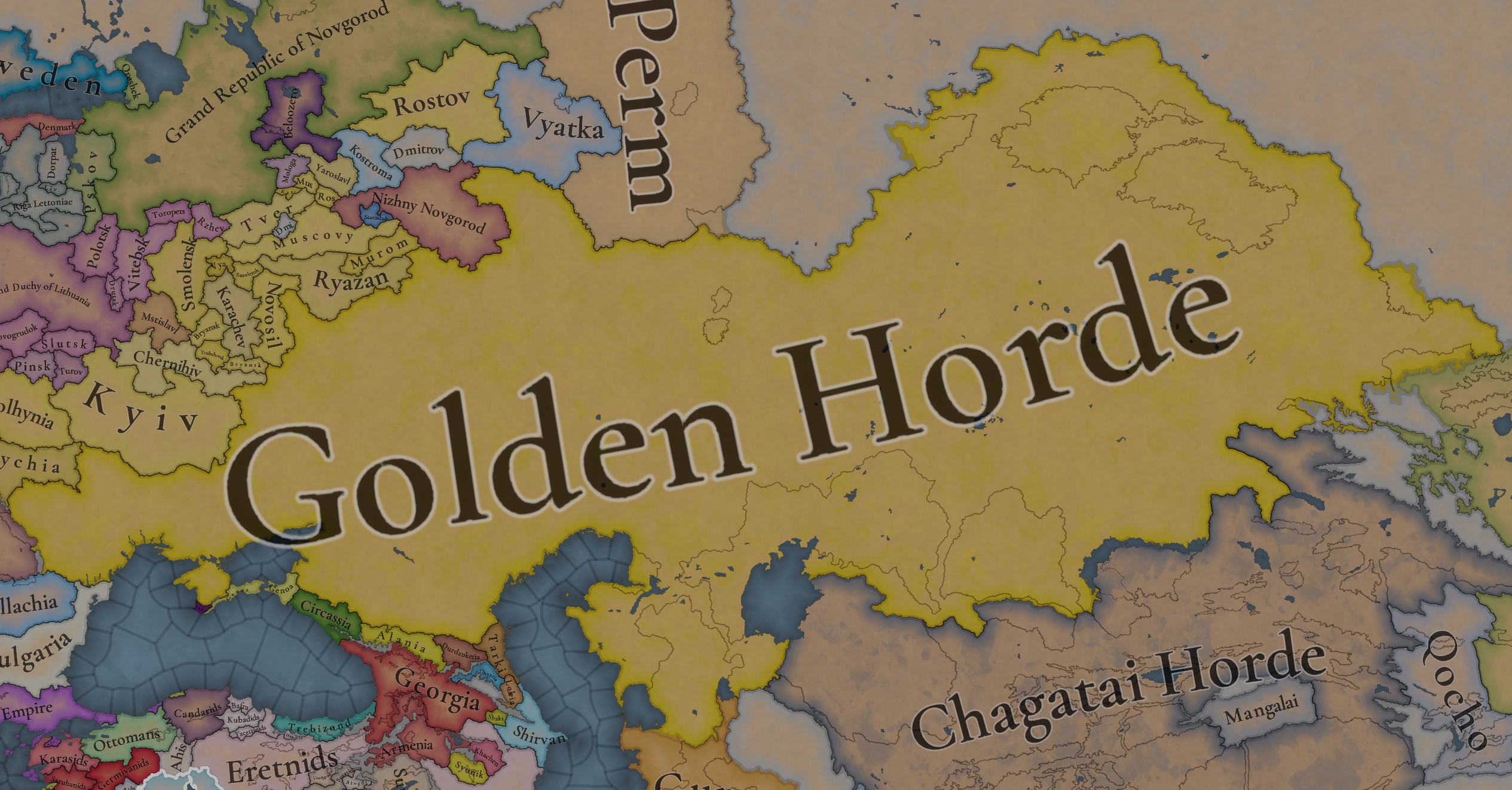
A glorious, Golden Horde! It is at its power peak, under the reign of Uzbeg Khan, so it's a much more menacing presence for its neighbors. However, it has its some internal issues that need to be managed, as you’ll notice in some of the maps, and in the future when we talk about the content for Hordes. The Golden Horde also heads its own IO, the Tatar Yoke, as shown in a previous Tinto Maps:

Tatar Yoke.jpg

We have already corrected the Ruthenian countries that are under the Horde’s Yoke, although we still have to correct the Russian principalities, which will be done in the corresponding Tinto Maps review. We’re also aware that we need to improve a bit the coloring of the IO, to mark not only the Golden Horde as the overlord of these countries, but also that Muscovy holds the title of the Grand Principality of Vladimir, which makes it the ‘enforcer’ of the Yoke. These fixes are also planned to be done in a few weeks.

Societies of Pops:
Societies of Pops.jpg

Societies of Pops 2.jpg .jpg

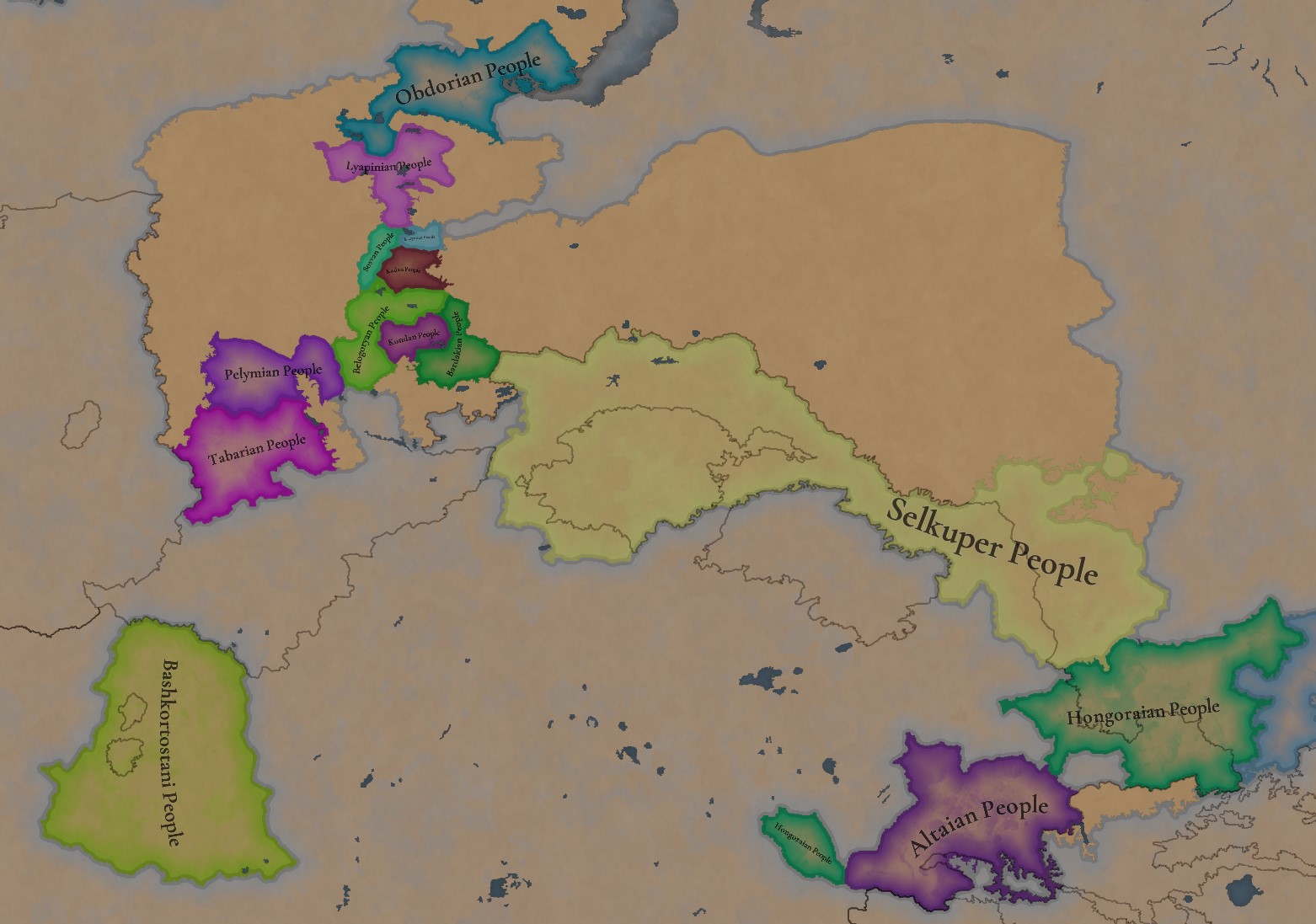
A bit up to the north, we have some Societies of Pops! This means that the territory of Western Siberia won’t be empty land, but will be populated by these people, which can be interacted with.

BTW, I’m not showing this week a dynasty map because, well, only the Borgijin dynasty rules over the lands of the Golden Horde, of course!


Locations:
Locations.jpg

Locations Western Siberia.jpg

Locations 3.jpg

Locations 4.jpg

Locations 5.jpg

Tons of locations today… You might notice that the density location is in a progression from west to east, from the most densely settled areas to the less settled ones. You may also notice that we’ve followed a design of ‘settler corridors’ in Western Siberia, setting those parts of the land that were habitable, usually on river valleys.

Provinces:
Provinces.jpg

Provinces 2.jpg


Areas:
Areas.jpg


Terrain:
Climate.jpg

Topography.jpg

Vegetation.jpg

The terrain is interesting here, as there are two main ecological areas. The first is the Steppes, Flatlands with Sparse and Grasslands vegetation, with either Cold Arid or Continental climates. And then we have the Siberian Arctics Forests, which are completely different, of course. On a note, the Urals were set as Hills, as they’re a quite settleable area, but we’ll probably make a review with your feedback, and add some mountains there.

Development:
Development.jpg

The whole region is not very developed, you might notice the difference with India, from last week’s Tinto Maps.

Harbors:
Harbors.jpg

There are some harbors in the Steppe region… In the Black Sea and Caspian Sea, of course! As usual, we’re open to feedback on this matter.

Cultures:
Cultures.jpg

Plenty of cultures! One note: Although we planned to work on the religious and cultural minorities of the region during the summer, we ended up not having enough time to add them. So what we’ll be doing today is showing the rough outline of ‘cultural spheres’, and then we’ll add the minorities during the review of the region. In that sense, feedback is very well received.

With that said the only note that needs to be made in terms of the cultural design is that we divided the Tatar cultural group into some differentiated regional cultures, being Crimean, Mishary, Kazani, and Astrakhani. We’re also aware that some of the cultures, as Mari and Chuvash, might be a bit displaced, as noted in the Russian Tinto Maps, so we’ll review and correct that with your feedback.


Religions:
Religions.jpg

Regarding Religions, the matter is a bit worse, as the big Sunni blob is just because the main religion of the Golden Horde is Islam, after the conversion of Uzbeg Khan, but that’s obviously incorrect. Also, as we have been able to forecast development time on how Pagan divisions will be during this autumn, we will make a comprehensive review of the region as well, to get a good distribution of ‘Shamanist’ Paganism, Tengrism, and Sunni Islam.

Raw Materials:
Raw Materials.jpg

Raw Materials 2.jpg

Raw Materials 3.jpg

Regarding the raw materials, the Steppes have plenty of Livestock and Horses, quite logically, although there are regions with some other goods. And up to the north, the main materials are Lumber and Fur. Apart from that, I want to mention the mineral hub in the Ural Mountains, with plenty of Copper, Iron, Gold, Lead, and Coal. That makes it a very mid and late-game interesting spot, and playing as Muscovy/Russia, I’ll tell you that you definitely want to expand into that region, as it will fulfill some of your material needs by that time.

Markets:
Markets.jpg

Markets! Big region, with lots of markets, although you may noticed that we changed the coloring of the locations that have 0% market access, which is the case in several areas. In any case, the market centers are Kaffa, Astrakhan, Saray-Jük, Kunya Urgench, Samarkand, Almaty, and Chimgi Tura. BTW, these names are much easier to notice in the game’s UI, as they’re beside the market centers:

Markets 2.jpg


Population:
Population.jpg

This week we’re showing only the country population mapmode, as there are some location numbers here and there which are failing, due to the already known issue with our pop editor (and which are on the way to be fixed). In any case, the whole population of the region is around 6.5-7M, of which around 6.3M are part of the Golden Horde. As I said, it’s a menacing country…

And that’s all for today! This is going to be my last Tinto Maps in a while, as I’ll be on vacation for 3 weeks during October (you might have noticed that I didn’t have any during summer), so one of the Content Designers in the team, @Roger Corominas , will step in and be in charge of the next 4 Tinto Maps. It’s in good hands, as Roger is an Experienced CD, who has been working and focused on Project Caesar for more than 3 years, at this point (this is why you might not know him from EU4, as other CDs in our team). In any case, he will be starting with the regions of Xinjiang, mostly ruled by the Chagatai Khanate, and Tibet.

I’ll keep reading and answering you during next week, and then I’ll be back in a month from now. See you!
 
  • 147Like
  • 48Love
  • 5
  • 3
  • 1Haha
Reactions:
I used these known cities from my previous map from September, but I have a feeling that I added -Saray because I saw Gulistan somewhere else. But I don’t remember exactly now.
But simply Gulistan or Gulistan-al-Djadid are obviously better, agree.


Agree.


Oh, it’s my ‘modern adaptation’, had to mention it in the notes too.
According to archaeological data, there was a big Horde city in 1337 located within the territory of modern-day Volgograd. The exact name is unknown, but the archaeological site was called Мечетное Городище (because of a local river):
So I used it, but better suggestions are welcome.

I will later update Gulistan and Xacitarxan.
So what have I found about it

Professor of the Novorossiysk University, F.K. Brun, was the first to express his opinion on the problem of its identification with the known Kipchak Khanate towns. He believed that it was possible to compare the Mechetnoye settlement with the town of Tortanly (Brun, 1873, P. 17). F.F. Chekalin adhered to the same point of view (Chekalin, 1889, P. 14-25).

The name is taken from the map of Venetian brothers Francesco, Dominic Pizigani / Pizigano
1746523856696.jpeg


The map is bad to say the least, the city of Ukek (marked lochahi, presumably because of the article al-Ukek) is placed on the Samara island.

The assumption of SUAC member Z. M. Yengalychev, “Tortanlli” is a distortion in the Italian language of the Tatar name of the area, derived from the word “Tar-tarle” (a narrow place bounded by a rampart and moat) or “Chortanly” (a river place rich in pike).

However as I understand, this version is not accepted, and there are huge disagreements
1746524130379.png


However, I believe it is better to use highly dubious naming rather than Mechet-Saray
 
  • 2Like
Reactions:
So what have I found about it

Professor of the Novorossiysk University, F.K. Brun, was the first to express his opinion on the problem of its identification with the known Kipchak Khanate towns. He believed that it was possible to compare the Mechetnoye settlement with the town of Tortanly (Brun, 1873, P. 17). F.F. Chekalin adhered to the same point of view (Chekalin, 1889, P. 14-25).

The name is taken from the map of Venetian brothers Francesco, Dominic Pizigani / Pizigano
View attachment 1290499

The map is bad to say the least, the city of Ukek (marked lochahi, presumably because of the article al-Ukek) is placed on the Samara island.

The assumption of SUAC member Z. M. Yengalychev, “Tortanlli” is a distortion in the Italian language of the Tatar name of the area, derived from the word “Tar-tarle” (a narrow place bounded by a rampart and moat) or “Chortanly” (a river place rich in pike).

However as I understand, this version is not accepted, and there are huge disagreements
View attachment 1290503

However, I believe it is better to use highly dubious naming rather than Mechet-Saray
No Wikipedia standard

But I would have gone with Tortanly

At least I found mention of it like that in german
Tortanly und Beljdjamen, nebst Uwek bei Saratow, gehören freilich geographisch nicht zu der Republik der Wolgadeutschen, dagegen ist ein Umstand
But it also calls Ukek by Uwek - wich is Slavic. But whatever. At least it resembles what is documented and you can google that place
 
  • 2Like
Reactions:
So what have I found about it

Professor of the Novorossiysk University, F.K. Brun, was the first to express his opinion on the problem of its identification with the known Kipchak Khanate towns. He believed that it was possible to compare the Mechetnoye settlement with the town of Tortanly (Brun, 1873, P. 17). F.F. Chekalin adhered to the same point of view (Chekalin, 1889, P. 14-25).

The name is taken from the map of Venetian brothers Francesco, Dominic Pizigani / Pizigano
View attachment 1290499

The map is bad to say the least, the city of Ukek (marked lochahi, presumably because of the article al-Ukek) is placed on the Samara island.

The assumption of SUAC member Z. M. Yengalychev, “Tortanlli” is a distortion in the Italian language of the Tatar name of the area, derived from the word “Tar-tarle” (a narrow place bounded by a rampart and moat) or “Chortanly” (a river place rich in pike).

However as I understand, this version is not accepted, and there are huge disagreements
View attachment 1290503

However, I believe it is better to use highly dubious naming rather than Mechet-Saray
I would like it too, nice work.

But it is a bit ridiculous, 10 minutes ago during my lunch at work I found some great XVI century maps and there is a town called Meshet (maybe it was spelled as Mes-het - Месхет) literally very nearby (where Gulistan should be, but we know that precision of those maps was not 100% perfect):
Meshet.png


I really do not know if it is a coincidence, but Meshet seems to be also reasonable :D

And on those maps there are a few really nice names in the Steppes, so I will make another iteration of update.
 
  • 2
Reactions:
So I have used better Google maps and tried to use actual settlements and avoid hydronyms as much as possible.
Priority was as follows:
  • Actual known Horde/Tatar settlements – green (Mechet-Saray is my adaptation of Мечётное городище).
  • Settlements present on the map but with minor improvement (e.g. Nizhniy Chir -> Chir) – dark red.
  • Turkic/Circassian/Chechen root settlements – dark red.
  • Slavic settlements with more neutral names (without -skiy, -skaya, -ovsk etc.) – dark red.
  • Turkic/Iranian hydronyms – blue. (actually only Kayaly, Mius and Khoper. Exception Yeysk -> Yeya because Yeysk is actually called by the Yeya river, so I do not count it as a pure hydronym)
  • *Some special notes - black.

Special notes:
  • Lysychansk -> Bayrak (previous early Cossack name was Lysychiy Bayrak, and bayrak is a Turkic term, so get rid of the adjective and we have a good name).
  • Luhansk -> Verhunka (the earliest Cossack settlement there, Turkic root Verhun, so could be also Verhun).
  • Yekaterinodar -> Bzhedygu-Kal (local Circassian name for Yekaterinodat at that time).
  • Bryukhovetskaya -> Boletecoi (Boletecoi is an actual town name from an old map, so why not to use it):
View attachment 1289962


And a special suggestion on renaming Posad -> Kayaly/Kalka. It is a Turkic name for the Kalmius river or for the Kalka rivers.
The Kalka was a significant place for the Rus and Mongolian/Turkic history. Not only because of the famous Rus-Mongolian battle (1223), but because when some Rus princes went to fight Cumans the chronilces used expression 'he went to the Kalka' meaning the region aroun the river. And Turkic name Kayaly fits good there for 1337.
Also, Posad is just a generic term for settlement. Obviously it represents modern-day Donetsk, but all of my Donetsk friend were surprised to see it because they did not know (neither Google) about any kind of 'posad' in the history of Donetsk.

So, the first southern part, lower Volga and Don region:

I will add other parts of the Steppes gradually to the thread, feel free to correct me.
Beldzhamen should probably be Beljamen
 
  • 1
  • 1Like
Reactions:
I would like it too, nice work.

But it is a bit ridiculous, 10 minutes ago during my lunch at work I found some great XVI century maps and there is a town called Meshet (maybe it was spelled as Mes-het - Месхет) literally very nearby (where Gulistan should be, but we know that precision of those maps was not 100% perfect):
View attachment 1290526

I really do not know if it is a coincidence, but Meshet seems to be also reasonable :D

And on those maps there are a few really nice names in the Steppes, so I will make another iteration of update.
Google directed me to a different map (Daniel Keller, 1590) but with the same Meshet. I also think it's Meskhet in English (The map is in Latin).

Meshet Daniel Keller 1590.jpg
 
  • 1Like
Reactions:
Maybe his point was that I have actually done that and posted suggestions long time ago, but the devs haven't changed any single Russified location name in Circassia:

View attachment 1288201

Like Abinskaya is literally called Abinskaya because of the local Circassian toponym Abin/Abna, or why don't they choose a nearby settlement Mezmay instead of obviously russified Moshchevo etc.
But looks like that that feedback was not taken into account if in Circassia we still have the same 4 Russified location names after review. And that is really disappointing. I did not notice it earlier.

P.S. This way I will not be surprised to find locations Imeni Voroshilova or Gidrouzel again after feedback post, unfortunately. And that instead of Oster location they still had a street name as a location name after 2 feedback posts.
So I was looking into the Sarai cities. Sarai-Berke and Sarai-Batu are one city. New Sarai was built by the Uzbek khan, so it can not be called Berke. I looked a lot and I think this is the latest understanding of the positions of cities

1746529475735.png


the picture is taken from here

So, it will make the final image like this
1746529654162.png


this way:
Sarai al-JadidСелитренное городище
Sarai (Sarai-Berke)Аксарайское городище
Xacitarxanгородище Шареный бугор
KizilКрасноярское городище
SumerkentМошаикское городище


I also think locations should be more like this. a bit bigger Astrakhan, Krasny Yar moved to the side, Rechnoye and Khoshentovo smaller, no Ganyushkino

1746530470196.png


Then everything will be much better aligned
 
Last edited:
  • 2Like
Reactions:
So I was looking into the Sarai cities. Sarai-Berke and Sarai-Batu are one city. New Sarai was built by the Uzbek khan, so it can not be called Berke. I looked a lot and I think this is the latest understanding of the positions of cities

View attachment 1290559

the picture is taken from here

So, it will make the final image like this
View attachment 1290562

this way:
Sarai al-JadidСелитренное городище
Sarai (Sarai-Berke)Аксарайское городище
Xacitarxanгородище Шареный бугор
KizilКрасноярское городище
SumerkentМошаикское городище
The picture also contains a better name for Ganyushkino: Buzanay (Bozanay) sands. Kotyk's map suggested Buzan (without -ay).
 
  • 3Like
Reactions:
Maybe his point was that I have actually done that and posted suggestions long time ago, but the devs haven't changed any single Russified location name in Circassia:

View attachment 1288201

Like Abinskaya is literally called Abinskaya because of the local Circassian toponym Abin/Abna, or why don't they choose a nearby settlement Mezmay instead of obviously russified Moshchevo etc.
But looks like that that feedback was not taken into account if in Circassia we still have the same 4 Russified location names after review. And that is really disappointing. I did not notice it earlier.

P.S. This way I will not be surprised to find locations Imeni Voroshilova or Gidrouzel again after feedback post, unfortunately. And that instead of Oster location they still had a street name as a location name after 2 feedback posts.
I also believe one location on the Don should be named Sarkel - historic city
 
  • 1
  • 1Like
Reactions:
The picture also contains a better name for Ganyushkino: Buzanay (Bozanay) sands. Kotyk's map suggested Buzan (without -ay).
I believe it is already the Ushtagan location. Nevertheless, locations must be retouched there. No reason to draw lines in the sand. Ganyushkino can be just merged with part of Krasny Yar, to create location of KIzil and the river that city has controlled
 
So I was looking into the Sarai cities. Sarai-Berke and Sarai-Batu are one city. New Sarai was built by the Uzbek khan, so it can not be called Berke. I looked a lot and I think this is the latest understanding of the positions of cities

View attachment 1290559

the picture is taken from here

So, it will make the final image like this
View attachment 1290562

this way:
Sarai al-JadidСелитренное городище
Sarai (Sarai-Berke)Аксарайское городище
Xacitarxanгородище Шареный бугор
KizilКрасноярское городище
SumerkentМошаикское городище


I also think locations should be more like this. a bit bigger Astrakhan, Krasny Yar moved to the side, Rechnoye and Khoshentovo smaller, no Ganyushkino

View attachment 1290571

Then everything will be much better aligned
If we want to add Saqsin, I would propose something like this

1746531397678.png
1746537841523.png
 
Last edited:
  • 2Like
  • 1
Reactions:
I also believe one location on the Don should be named Sarkel - historic city
Yes, I thought about it too, moreover, there is Sarkel now:
1746531181191.png


In the end Ust-Tsimla was not really the worst name on the map, so I left it. But I agree Sarkel is better for a historic strategy.

Regarding this:
So I was looking into the Sarai cities. Sarai-Berke and Sarai-Batu are one city. New Sarai was built by the Uzbek khan, so it can not be called Berke. I looked a lot and I think this is the latest understanding of the positions of cities

View attachment 1290559

the picture is taken from here

So, it will make the final image like this
View attachment 1290562

this way:
Sarai al-JadidСелитренное городище
Sarai (Sarai-Berke)Аксарайское городище
Xacitarxanгородище Шареный бугор
KizilКрасноярское городище
SumerkentМошаикское городище


I also think locations should be more like this. a bit bigger Astrakhan, Krasny Yar moved to the side, Rechnoye and Khoshentovo smaller, no Ganyushkino

View attachment 1290571

Then everything will be much better aligned
I have no bias towards any option because probably the only city we can be ~100% sure about is probably Xacitarxan - Astrakhan because it exists today.
And we know that there were really a lot of rich Horde around the Volga estuary, as well as near Volga-Don corridor. Some sources suggest the capital was there, even the original Tinto Map.
Evliya Celebi Ibn Battuta described his travel to the Horde in 1334 and used Sarai-Berke name for the old Sarai, so there is a mess around it :)
More locations are definitely needed there to reflect the density and show all important cities.
But I will be OK with any combination because no-one really knows for sure.
1746533326659.png
 
Last edited:
  • 2
Reactions:
Buuuuut, Xacitarxan and Astrakhan are located in different places. Even on the map you show Hajji Tarkhan is Sharenyy Bugor - not Astrakhan
Yes, I meant after the destruction by Timur it was rebuilt not far from there so some kind of continuity was 'preserved'. And unlike other cities, there is some accordance between scientists about it.
 
  • 2
Reactions:
Maybe his point was that I have actually done that and posted suggestions long time ago, but the devs haven't changed any single Russified location name in Circassia:

View attachment 1288201

Like Abinskaya is literally called Abinskaya because of the local Circassian toponym Abin/Abna, or why don't they choose a nearby settlement Mezmay instead of obviously russified Moshchevo etc.
But looks like that that feedback was not taken into account if in Circassia we still have the same 4 Russified location names after review. And that is really disappointing. I did not notice it earlier.

P.S. This way I will not be surprised to find locations Imeni Voroshilova or Gidrouzel again after feedback post, unfortunately. And that instead of Oster location they still had a street name as a location name after 2 feedback posts.
saw a gap there, I would propose something like this
1746538319894.png
1746699948838.png


Muran - modern village muranka - from turkic muran name of the river. Samar just one more variation of spelling I took from Italian map


Also on the other side of the river from Ukek (Engels location) I propose Jalak - Квасниковским городищем - inspired by the maps of Venetian brothers Francesco, Dominic Pizigani / Pizigano (they marked it as yolachi)

1746538608448.png
 
Last edited:
  • 4
Reactions:
saw a gap there, I would propose something like this
View attachment 1290665View attachment 1290666

Muran - modern village muranka - from turkic muran name of the river. Zhiguli - I believe it should be like that in both Slavic and Turkic languages, there is Murom gorodok (муромский городок) - unfortunately, this settlement is unnamed. Samar just one more variation of spelling I took from Italian map


Also on the other side of the river from Ukek (Engels location) I propose Jalak - Квасниковским городищем - inspired by the maps of Venetian brothers Francesco, Dominic Pizigani / Pizigano (they marked it as yolachi)

View attachment 1290667
That gap was there those were not so obvious Slavic, so I did not prioritise them, but thanks.

Concerning Samar I have another location for this name, a historic Cossack town and a fortress:
So maybe I would leave Samara here . Both towns are called by the local rivers, both rivers were called Samar and then Samara, so let the devs decide which one will be Samar and which Samara :)

And Jalak sounds nice, I'll note it, thanks.
 
Last edited:
  • 1Like
Reactions:
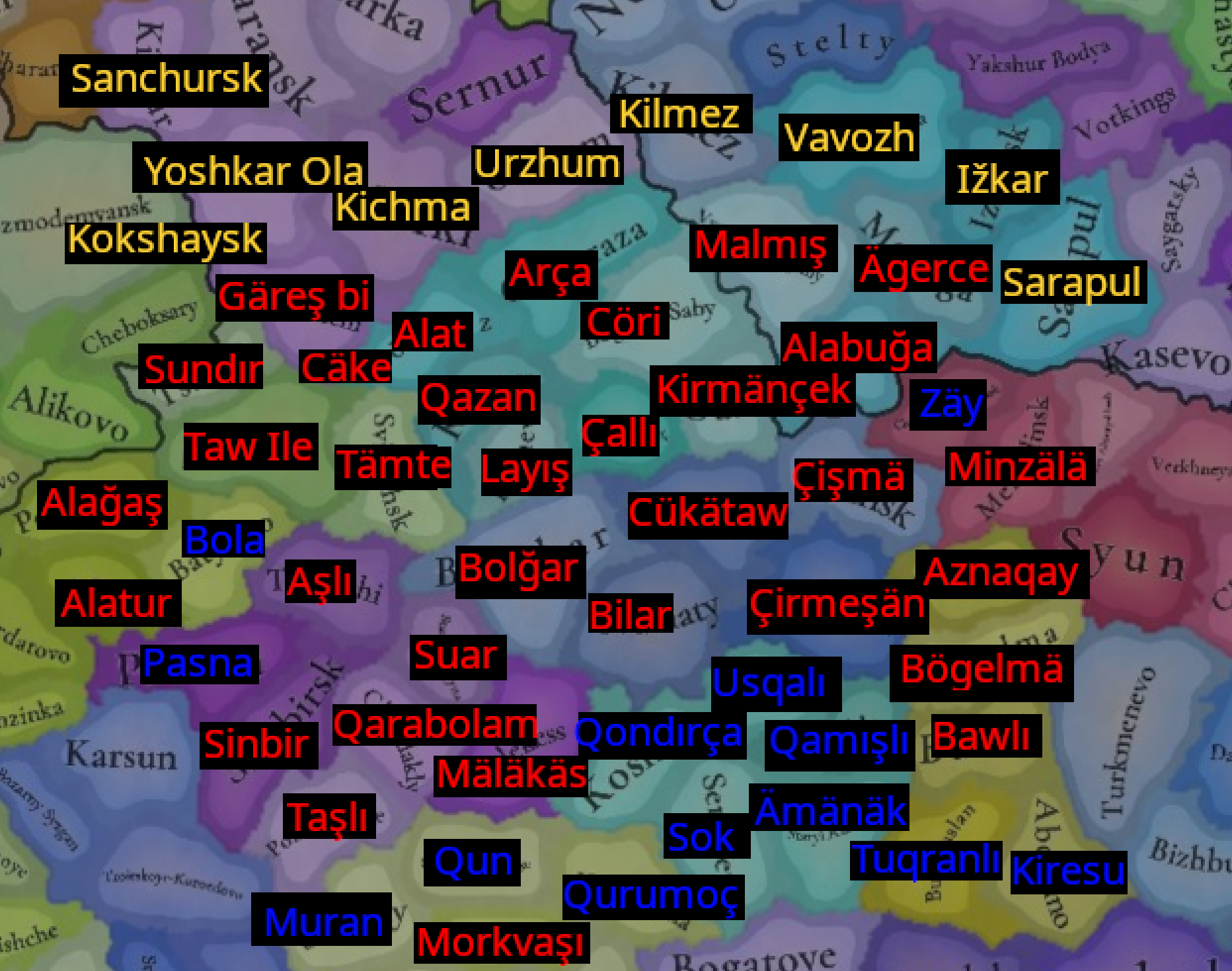
Here is the map of Volga Bulgaria

1746700005925.png


Red - Tatar city names
Blue - Tatar river names
Yellow - other

As a basis, I took those two maps

1746620979068.png
1746621024268.png

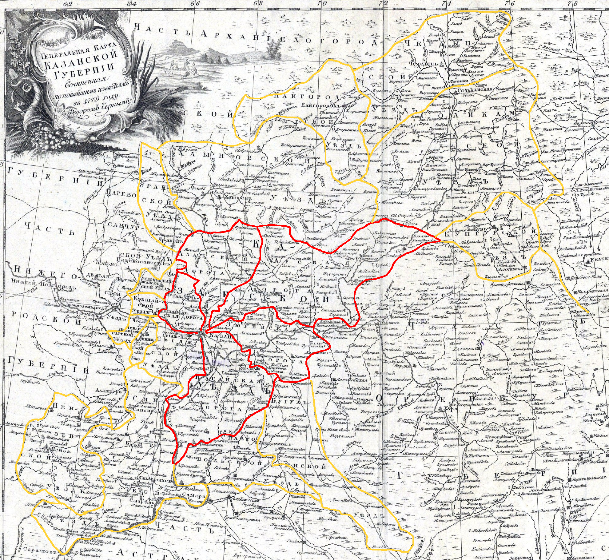
The first one is 1779 map of Kazan governorate, the second is the map of the Kazan Khanate

And, If you look closely, you can see that divisions in the Kazan governorate called Darugi - a remnant of the Kazan Khanate administrative divisions. So, I propose to create Provinces like those divisions - something like Novgorod has right now
1746621608949.png

I marked the Dorugas in red and the other divisions in yellow. As you can see, one (Crimean Daruga) is speculated to be assimilated into the Russian Uezd system.


Here I outlined this map on the EU5 map as well as I could. As you can see, somewhere the provinces don't align at all

1746625359547.png

So with red dotted lines, I marked old divisions of the Khanate from the second map
Everything else is from the first map


Few location changes.
1746623910924.png

With this darugas will align much better with maps
It will also allow us to represent more cities like Cäke and Koshaysk,
Cities like Bilar, Suar, Alat, Arça and Cöri will be represented much better
 
Last edited:
  • 3Like
  • 1Love
  • 1
Reactions:
Here is the map of Volga Bulgaria

View attachment 1291707

Red - Tatar city names
Blue - Tatar river names

As a basis, I took those two maps

View attachment 1291709View attachment 1291710
The first one is 1779 map of Kazan governorate, the second is the map of the Kazan Khanate

And, If you look closely, you can see that divisions in the Kazan governorate called Darugi - a remnant of the Kazan Khanate administrative divisions. So, I propose to create Provinces like those divisions - something like Novgorod has right now
View attachment 1291722
I marked the Dorugas in red and the other divisions in yellow. As you can see, one (Crimean Daruga) is speculated to be assimilated into the Russian Uezd system.


Here I outlined this map on the EU5 map as well as I could. As you can see, somewhere the provinces don't align at all

View attachment 1291803
So with red dotted lines, I marked old divisions of the Khanate from the second map and extensions + other divisions from the first map (Yellow)


Few location changes.
View attachment 1291771
With this darugas will align much better with maps
It will also allow us to represent more cities like Cäke and Koshaysk,
Cities like Bilar, Suar, Alat, Arça and Cöri will be represented much better
Very nice!
Volga Bulgaria was one of the richest and settled parts of the Golden Horde so I would also welcome increase of location density there.
 
  • 2Like
  • 1
Reactions:
Very nice!
Volga Bulgaria was one of the richest and settled parts of the Golden Horde so I would also welcome increase of location density there.
Yeah, however, this decision depends on developers. I tried to take the most important cities, but there are a lot of tradeoffs, like the castle of Tetushi is lost to the historic Volga Bulgaria city of Aşlı

On the other side adding more locations can worsen the case of single Volga Bulgaria area

However, if they want to do more (reasonable only near Kazan), then the second map I have attached is the best to use

For me, it will work either way
I just hope we will not receive Tinto Feedback, where everything will stay in place (no changes at all)

I hope @Aldaron can direct us on what we have to do so our feedback is included, and do we still have time to submit it
 
Last edited:
  • 1
  • 1Like
Reactions:
I also believe one location on the Don should be named Sarkel - historic city
Yes, it is marked on the map of Donskoy ulus (Terkliy?) like a fortified settlement.

There are also a couple of maps of the locations of burial grounds (large cemeteries), which usually occur near cities. It makes sense to look for nomad cities in these places:
1746640883556.png

1746640865803.png