Hello and welcome another week to the amazing world of Tinto Maps. This week we are covering a very wide area, as we will take a look at Mongolia, Manchuria and all Eastern Siberia. So, without much further ado, let’s get started.
Countries


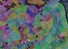
 Here, clearly, the Yuán Dynasty of China controls much of the territory, while all of the Siberian expanses are “open” to colonization. Considering Manchuria, the Jurchen tribes posed a tricky question, as some of them were more settled and Chinese-influenced while others were more nomadic and pastoralist, and some were in between. Thus, we decided to represent the more settled tribes that would later confederate into the Manchu as separate countries vassals of Yuán, while there is also Jurchen population inside the borders of Yuán itself and the most nomadic of them represented as Society of Pops.
Societies of Pops

And speaking of that, most of them are obviously concentrated in Manchuria and around the borders of the countries and coasts, while the more inhospitable places further into Siberia and Kamchatka are more sparsely populated and thus less organized.
Dynasties

Nothing that wasn’t expected here, Borjigin dynasty keeps dominating another week. Concerning the Jurchen, currently none of them have scripted dynasties assigned and are generated instead.
Locations


Provinces


Areas

Terrain


The drier parts of the Gobi Desert in the Mongolian Plateau give way to the steppes and grasslands of Manchuria, while further into Siberia it gets dominated by mountains, hills, forests, and as one would expect from Siberia, cold.
Development

Not much development in these parts either, and as I mentioned in last week’s Tinto Maps, the sudden change in development when entering China will have to be reviewed, as it’s currently too strong.
Natural Harbors

Cultures


 Quite a varied cultural landscape, as these areas are populated by many different peoples, sometimes expanding through a wide area while others are more localized. On the other hand, the Mongolian Plateau is very much dominated by Mongolian culture.
Religions

Very diverse religion distribution too, with Tengri, Shamanism, and local variations of it with Tungustic Shamanism (brown), Yukaghir Shamanism (light blue) and Chukchee Shamanism (purple). I have to say that we are currently going through a review of all the religions of the world defined as either “Animism” or “Shamanism”, so it is possible that there are some changes in this distribution in the future.
Raw Materials


 Very marked distribution of resources, with Mongolia and Manchuria rich in livestock and horses (as one would expect from the horse lords) while the forests of Siberia are full of fur and wild game and the northern coasts are a big source of ivory (from the world-famous arctic elephant herds, of course). However, the mountainous areas also include precious metals like gold and silver, so their colonization may thus prove quite beneficial. Another thing of note is that fish can be found abundantly not only along the coasts but also along the major rivers crossing Siberia.
Markets

First of all, we have reverted back to the previous way of visualizing markets, as it was clear that the change we did to it was not in the good direction. We will keep testing and trying things, so this will probably not be the final view of it, but for now we reverted back to this version as we think it would be clearer to present. Having said that, these are areas with not much market presence, with the markets of Karakorum and Ilan Hala being the main ones, and the Chinese markets encroaching on the southern parts. Siberia doesn’t have any market of its own, so all of it has currently no access.
Population


 The only countries we have population to show here are the Jurchen ones, with the mighty Yuán ever encroaching on them. Concerning the populations of the locations, one thing I have to mention is that you will see many of them with the value of 150, that is the general default value that we used for the less populated areas of all eastern Siberia, where population estimates of the period don’t allow for much fine tuning. It is probably something that we will adjust.
And that is it for this week. Next week, after having been teasing it and slithering around its edges for a while now, it will be finally time to face the dragon, as we will showcase the entirety of China. Hope to see you all there, and as always very open (and grateful) to all your feedback.
Countries
Societies of Pops
And speaking of that, most of them are obviously concentrated in Manchuria and around the borders of the countries and coasts, while the more inhospitable places further into Siberia and Kamchatka are more sparsely populated and thus less organized.
Dynasties
Nothing that wasn’t expected here, Borjigin dynasty keeps dominating another week. Concerning the Jurchen, currently none of them have scripted dynasties assigned and are generated instead.
Locations
Provinces
Areas
Terrain
The drier parts of the Gobi Desert in the Mongolian Plateau give way to the steppes and grasslands of Manchuria, while further into Siberia it gets dominated by mountains, hills, forests, and as one would expect from Siberia, cold.
Development
Not much development in these parts either, and as I mentioned in last week’s Tinto Maps, the sudden change in development when entering China will have to be reviewed, as it’s currently too strong.
Natural Harbors
Cultures
Religions
Very diverse religion distribution too, with Tengri, Shamanism, and local variations of it with Tungustic Shamanism (brown), Yukaghir Shamanism (light blue) and Chukchee Shamanism (purple). I have to say that we are currently going through a review of all the religions of the world defined as either “Animism” or “Shamanism”, so it is possible that there are some changes in this distribution in the future.
Raw Materials
Markets
First of all, we have reverted back to the previous way of visualizing markets, as it was clear that the change we did to it was not in the good direction. We will keep testing and trying things, so this will probably not be the final view of it, but for now we reverted back to this version as we think it would be clearer to present. Having said that, these are areas with not much market presence, with the markets of Karakorum and Ilan Hala being the main ones, and the Chinese markets encroaching on the southern parts. Siberia doesn’t have any market of its own, so all of it has currently no access.
Population
And that is it for this week. Next week, after having been teasing it and slithering around its edges for a while now, it will be finally time to face the dragon, as we will showcase the entirety of China. Hope to see you all there, and as always very open (and grateful) to all your feedback.